|
2. TRANSPORTATION MANAGEMENT IMPLEMENTATION PLAN FOR RICHMOND ROAD/WESTBORO
PLAN DE MISE EN OEUVRE DE LA GESTION DU TRANSPORT POUR LE SECTEUR DU CHEMIN RICHMOND/WESTBORO
|
COMMITTEE RECOMMENDATION
That, subject to funding approval in the 2011 Budget, Council approve the Transportation Management Implementation Plan for Richmond Road/Westboro as outlined in Document 1.
RECOMMANDATION DU COMMITTEE
Que, sous réserve de l’approbation du financement dans les budget de 2011, le Conseil approuve le Plan de mise en œuvre de la gestion du transport pour le secteur du chemin Richmond/Westboro, comme le décrit dans le document 1.
Documentation
1. Deputy City Manager, Infrastructure Services and Community Sustainability report dated 10 December 2010 (ACS2011-ICS-PGM-0017).
Report to/Rapport au :
and Council / et au Conseil
10 December 2010 / le 10 décembre 2010
Services d’infrastructure et Viabilité des collectivités
Contact/Personne ressource : Vivi Chi, Manager/Gestionnaire, Transportation Planning/Planification des transports, Planning and Growth Management/Urbanisme et Gestion de la croissance
(613) 580-2424 x 21877, Vivi.Chi@ottawa.ca
SUBJECT: |
TRANSPORTATION MANAGEMENT IMPLEMENTATION PLAN FOR RICHMOND ROAD/WESTBORO |
|
|
|
OBJET : |
PLAN DE MISE EN OEUVRE DE LA GESTION DU TRANSPORT POUR LE SECTEUR DU CHEMIN RICHMOND/WESTBORO |
REPORT RECOMMENDATION
That, subject to funding approval in the 2011 Budget, the Transportation Committee recommend Council approve the Transportation Management Implementation Plan for Richmond Road/Westboro as outlined in Document 1.
RECOMMANDATION DU RAPPORT
Que, sous réserve de l’approbation du financement dans les budget de 2011, le Comité des transports recommande au Conseil d'approuver le Plan de mise en œuvre de la gestion du transport pour le secteur du chemin Richmond/Westboro, comme le décrit dans le document 1.
BACKGROUND
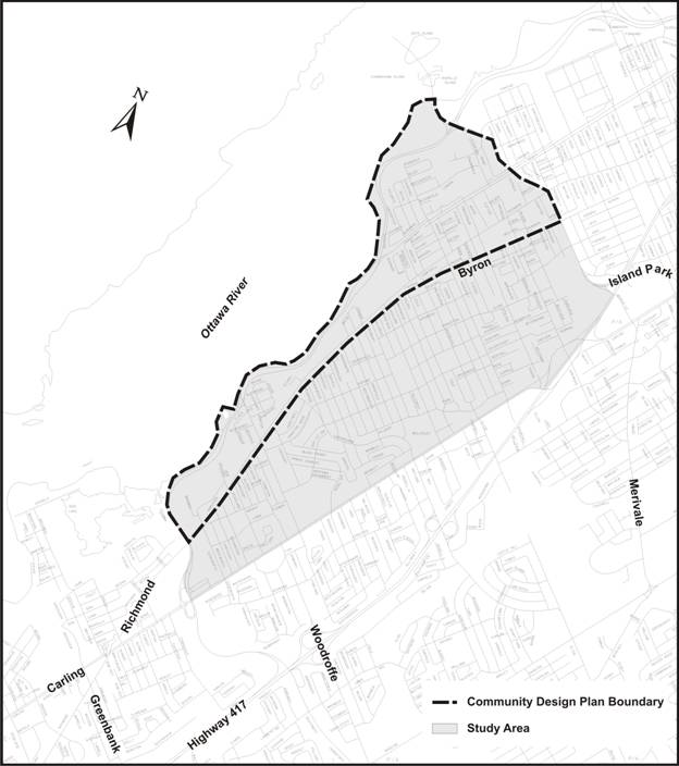
In July 2007, City Council approved a Community Design Plan (CDP) for the Richmond Road/Westboro area that is intended to guide future design and land use development for the next 10 to 15 years. It is projected that over this time period up to 4,000 new residential units could be built in the area through intensification and infill development. The area covered by the CDP is bounded by Island Park Drive on the east, the Ottawa River Parkway on the north and west, and the Richmond Road/Byron corridor on the south.
During the development of the CDP, a Transportation Impact Study (TIS) was commissioned. The TIS examined the impacts of the 2021 build-out scenario described in the CDP. A key outcome of the study report was the conclusion that, should existing transportation behaviours remain consistent, certain segments and intersections along Richmond Road would need to be widened in order to offer an acceptable level of service for automobile traffic. The community voiced a strong disapproval to widening the corridor for more car lanes and, in response, the TIS suggested that an alternative to widening Richmond Road would be to significantly reduce the Richmond Road automobile modal share (the percentage of trips made by private automobile as compared to all other transportation modes). As a consequence of this TIS recommendation, when Council approved the CDP, direction was given that a Transportation Management Implementation Plan (TMIP) be prepared with the purpose of identifying initiatives that can be implemented over the next 15 years to promote alternative modes of transportation and ensure an adequate level of service without providing additional automobile capacity.
Since the preparation of the CDP in 2007, Council has also approved the Ottawa Pedestrian Plan and the Ottawa Cycling Plan both of which include many initiatives that are fully supportive of the policy and infrastructure recommendations found in the proposed TMIP. In addition, since the CDP's completion, redevelopment in the Richmond Road corridor is occurring and the implementation of TMIP recommendations is warranted. The TMIP is supportive of many objectives of the City's Strategic Plan.
DISCUSSION
This section of the report outlines the main content and recommendations of the proposed TMIP. In brief the TMIP included a review of the existing transportation network and travel patterns within the study area and surrounding community. The existing peak hour modal shares for all modes were reviewed and targets were set for each. A phased implementation plan was also developed comprising numerous initiatives to encourage walking, cycling, and transit ridership. A performance monitoring plan is proposed to allow the City to periodically assess the success of these proposed initiatives and adjust the implementation plan accordingly. Document 1 provides a link to a full copy of the TMIP.
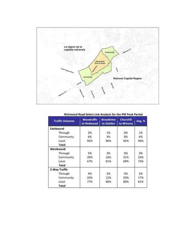
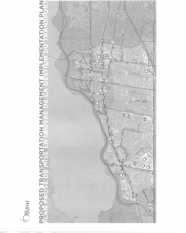
The TMIP covers a wider geographical area than the CDP by including the neighbourhoods south of Richmond/Byron extending to Carling Avenue (see Figure 1). This residential area to the south is generally more stable and less subject to change and therefore was not included in the CDP. However it is very much part of the larger Richmond Road/Westboro corridor as it influences transportation patterns. Therefore, it was necessary to include those neighbourhoods in the TMIP.
Figure 1 - CDP and Study Area Boundaries
The following describes key issues and recommendations of the TMIP.
PROBLEM STATEMENT
In order to develop a set of initiatives that work to promote alternative transportation, the factors that affect transportation behaviour in the community must be well understood. An examination of current land use and demographics (current and future) was made. An analysis of the origin and destination survey revealed that most traffic along Richmond Road is either: i) local - starts and ends within the study area, or, ii) community - starts in the study area but ends in an area that is adjacent, or conversely, starts in an adjacent area and ends in the study area. Between 95 and 98 per cent of trips fall in those categories with only a very minor amount of a third category of "through" traffic that cuts completely through the study area or has an origin or destination far from the study area (see Document 2).
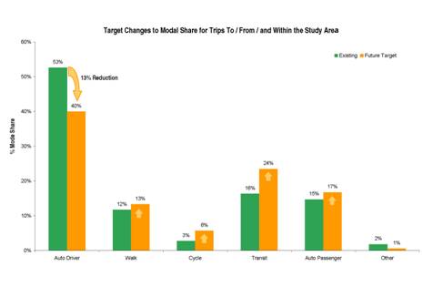
Based on the most recent data available regarding trip origins and destinations in the study area, and considering the 2021 projected traffic volumes for Richmond Road, it has been concluded that the automobile modal share must be reduced from 53 per cent (existing) to 40 per cent (2021) in order to achieve acceptable Levels of Service at the intersections along Richmond Road. This represents a 13-per cent reduction in the number of people who drive private automobiles along Richmond Road.
Potential transportation solutions involved determining key travel pattern modal share objectives as shown in the figure below. These include a reduction in single occupied vehicle use and increases in walking, cycling, transit and car-pooling.
Figure 2
PUBLIC INVOLVEMENT
The TMIP’s success is wholly dependent on community uptake and ownership of the proposed initiatives. As such, meaningful public consultation, through various hands-on workshops, was an integral part of the development of this plan in order to ensure that the proposed measures match the needs and preferences of the community and address the specific barriers to walking, cycling, and taking transit that residents face today. The comments and perspectives that were shared during three public consultation events were used extensively in the development of this plan. In summary, through strategic stakeholder engagement, the proposed TMIP aims to reflect the attitudes and opinions of those from the Westboro community who participated in the project. In addition, the TMIP aims to complement the City’s other pedestrian, cycling, and transit objectives which have been developed in past years with input from residents of all of Ottawa.
RECOMMENDATIONS
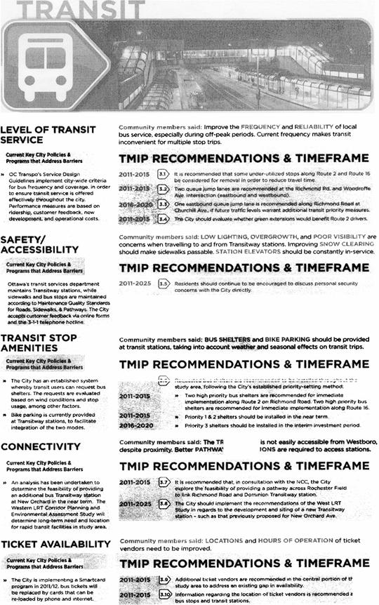
A number of transportation demand initiatives were presented to the public that could work for the Westboro community. The highest ranked initiatives, which were supported by 90 per cent of the workshop participants, included: 1) transit stop amenities, 2) bicycle lanes, 3) community transit routes, 4) transit lanes, 5) transit passes, 6) bicycle-transit integration, and 7) bicycle parking/storage. These initiatives are summarized below (by mode):
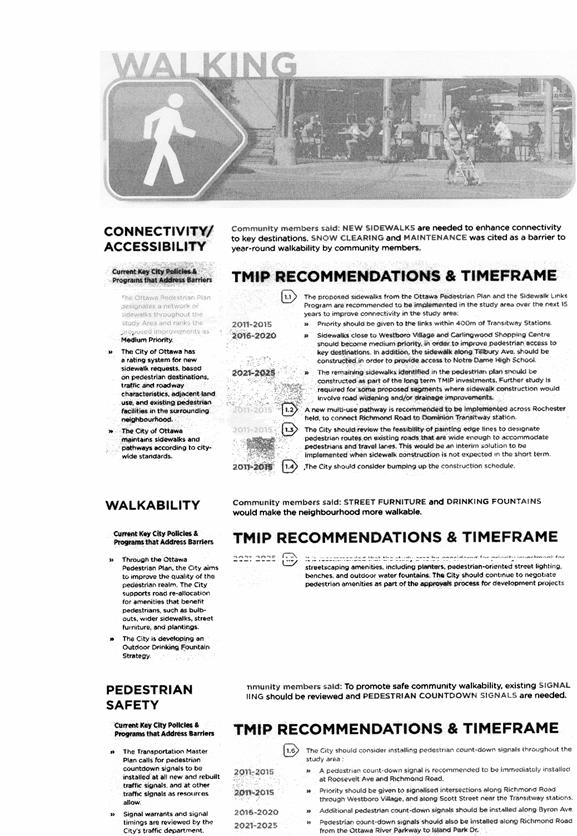
WALKING - highlights include: increasing the number of sidewalks as per the Ottawa Pedestrian Plan with priority given to those locations leading to transit stations; a continuation of installing pedestrian countdown signals; and adding a new multi-use pathway in order to connect Richmond Road to Dominion Transitway station.
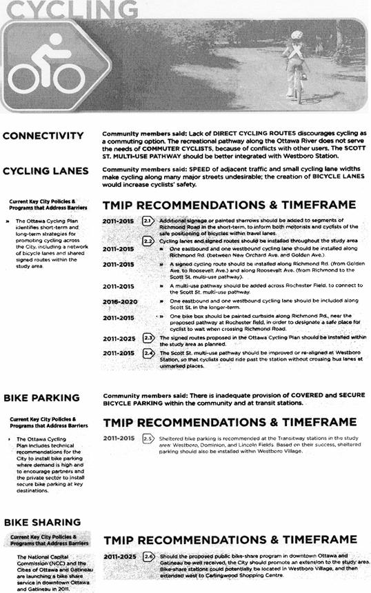
CYCLING - highlights include: adding weather protected bike racks at Transitway stations (Westboro, Dominion and Lincoln Fields) in the study area and later to Westboro Village; introducing shared use lanes and bicycle lanes as per the Ottawa Cycling Plan; investigate use of a Rochester Field for a multi-use pathway connection; improvement to cycling facilities along Scott Street including connectivity at the Westboro Transit Station.
TRANSIT - highlights include: deferring any decision on an additional transit station on the Ottawa River Parkway to the results of the Western LRT Corridor EA study (in progress); requesting Transit Service to review usage and adjust stop spacing for routes 2 and 16; introducing additional bus shelters along these routes and that of route 151; and investigating additional queue jump bus lanes to alleviate delay to transit vehicles.
Other TRANSPORTATION DEMAND MANAGEMENT measures include: having an individualized travel planning pilot program developed to target a specific neighbourhood within the study area; monitor the success of the two pilot School Travel Planning programs on-going in the study area and if these programs are successful at managing transportation pressures consider supporting the expansion of the program to the other schools in the study area.
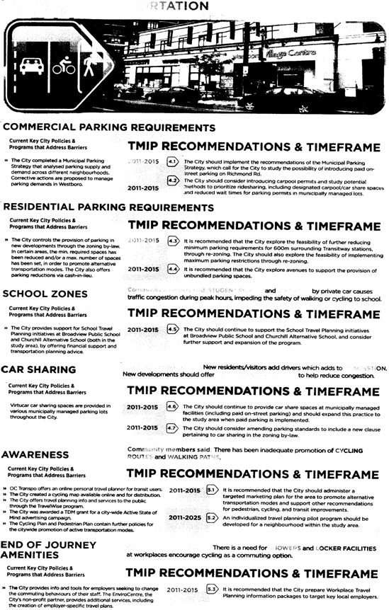
PARKING - highlights include: supporting dedicated car share spaces in municipal parking lots if parking lots are introduced; providing specially designated carpool spaces either within the existing on-street parking or within any municipally-managed lot that might be introduced to the area; consider changing the parking cap from 1.75 to 1.5 spaces per unit for multi-unit residential developments in the areas within 600 metres of transit stations, similar to the provisions for Tunney’s Pasture Mixed-Use Centre; and, subject to detailed discussion with the BIA and community, that pay parking be studied for possible implementation for all on-street parking spaces on Richmond Road between Golden Avenue and Island Park Drive.
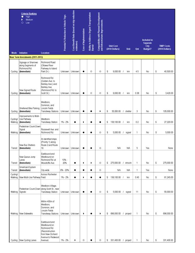
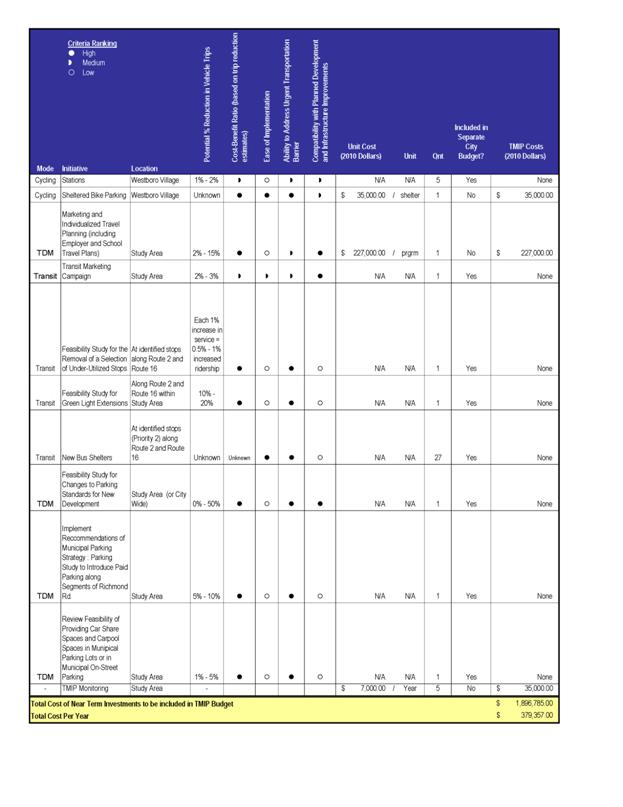
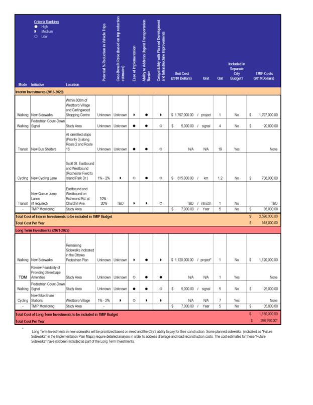
Document 3 provides a summary of the TMIP recommendations arranged by categories of walking, cycling, transit, auto/parking and other issues.
PRIORITY SETTING
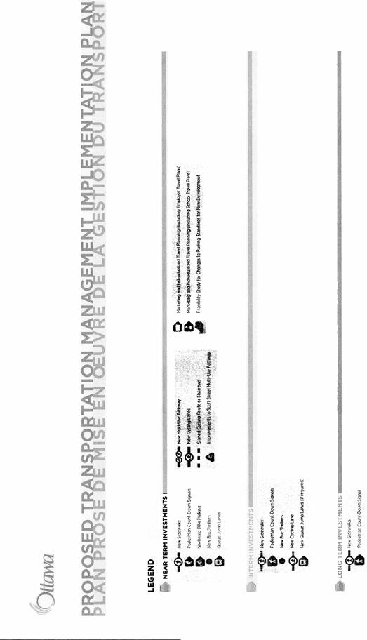
The various transportation initiatives have been prioritized into near term (2011-2015), interim term (2016-2020) and long term (2021- 2025) investments. To ensure that this plan will have an immediate and recognizable impact on travel behaviour in the community, initiatives that are consistent with existing City policies and programs were given priority as immediate investments. Construction projects that are independent of other initiatives and projects with short timeframes were also identified as “easy to implement” short term improvements. By prioritizing these projects, the City can balance making progress towards the TMIP goals, while still focusing resources towards longer term improvements. Initiatives that require major changes to City policy or require further design/research/approvals will require longer implementation timeframes and are therefore identified for future project phases.
IMPLEMENTATION PLAN
Document 4 outlines the initiatives proposed by the time periods. The TMIP also provides maps in colour showing geographically these various initiatives. The short term costs are estimated (all in 2010 dollars) to be $1.9 million or $380,000/year, the interim term costs would be $2.6 million or $520,000/year and the long term $1.2 million or $300,000/year.
MONITORING
Over the 15-year time horizon of the TMIP data collection and analysis will be required in order to monitor the effectiveness of the initiatives contained within it. This starts with collecting a baseline of data and a monitoring program to allow for periodic revisions to the TMIP. A monitoring template of objective specific outcome indicators and overall mode specific outcome indicators is proposed.
ADDITIONAL REVIEW/STUDY
The TMIP document suggests further action/study as to merits of several recommendations made. These include:
i) studying sidewalk options/alternatives on streets with ditches;
ii) study the possibility of introducing paid parking on Richmond Road further to consultation requirements of the Municipal Parking Management Strategy;
iii) lowering the cap on maximum parking for residential parking within 600 metres of rapid transit stations in the study area; and
iv) the proposed pathway across the National Capital Commission's Rochester Field.
NEXT STEP
Approval of the TMIP will permit the start of implementation in 2011, subject to budget funding approval and further consultation with the two ward Councillors and community as necessary.
RURAL IMPLICATIONS
N/A
CONSULTATION
Development of the Plan included stakeholder (community groups, BIAs, school groups) consultation workshops held on May 17 and May 18, 2010. The Pedestrian and Transit Advisory Committee and the Road and Cycling Advisory Committee were invited and the former provided contact representatives throughout the process. Public Open Houses were held on June 29 and September 16, 2010. Reference can be made to the TMIP's Appendix A - Consultation Summary Report which outlines in detail the feedback received during consultation. The project website also included an ability to provide feedback comments.
COMMENTS BY THE WARD COUNCILLOR(S)
Councillor Mark Taylor: While I am in agreement with; and supportive of, this implementation – I do wish to highlight that part of its visible and tangible impact on Bay Ward and our entire community will be dependent on the outcome of the Western Corridor LRT study currently underway. While implementing this TMIP and accepting the staff recommendation does not clearly identify selected corridors for LRT I would impress that it becomes increasingly important for Council and local stakeholders to be fully engaged in the Western Corridor selection process so that no one, from community to Council feels blindsided by the selection process. In plain English: I would never want the Western LRT Corridor selection to simply ‘slip through’ without deep engagement and have Council feel ambushed when, as a result of accepting this TMIP the selected corridors move to implementation swiftly and residents become alarmed.
Councillor Katherine Hobbs: The Ward Councillor is aware of this report.
LEGAL/RISK MANAGEMENT IMPLICATIONS
There are no legal/risk management impediments to implementing the recommendation in this report.
CITY STRATEGIC PLAN
The TMIP is supportive of the following City Strategic Plan initiatives:
Transportation - Objective 1: Improve the City’s transportation network to afford ease of mobility, keep pace with growth, reduce congestion and work towards modal split targets.
Transit - Objective 1: Achieve a 30 per cent modal split by 2031.
Solid Waste and Environment - Objective 1: Enhance environmental sustainability and reduce greenhouse gas emissions by 30 per cent (corporate) and 20 per cent (community) from 1990 levels by 2012.
Sustainable, Healthy and Active City - Objective 6: Require walking, transit and cycling oriented communities and employment centres; Objective 11: By 2017, close the gap in sidewalks, traffic lights, street lights and bicycle lanes in infrastructure that has been warranted and unfunded
TECHNICAL IMPLICATIONS
N/A
FINANCIAL IMPLICATIONS
The approval of the TMIP will require the commitment of consistent funding during a period of 15 years to implement the initiatives proposed; including a monitoring component. Many of the initiatives found in the Plan also form part of the Council-approved Ottawa Pedestrian Plan and Ottawa Cycling Plan for which there is already direction for their implementation. Projects will be implemented as annual funding is provided. A request for $200,000 (905930) has been put forward as part of the 2011 capital budget process budget.
SUPPORTING DOCUMENTATION
Document 1 Draft TMIP at
http://www.ottawa.ca/residents/public_consult/westboro/draft_plan_en.html
Document 2 Richmond Road Through Traffic (Map and Table)
Document 3 Summary of TMIP recommendations
Document 4 Implementation Table
DISPOSITION
Following Committee and Council's approval of the TMIP and corresponding capital budget approval, Planning and Growth Management staff will proceed with the implementation of the projects as identified in the study.
RICHMOND ROAD THROUGH TRAFFIC (MAP AND TABLE) DOCUMENT 2
SUMMARY OF TMIP RECOMMENDATIONS DOCUMENT
3
IMPLEMENTATION TABLE DOCUMENT 4