|
|
COMMITTEE RECOMMENDATION
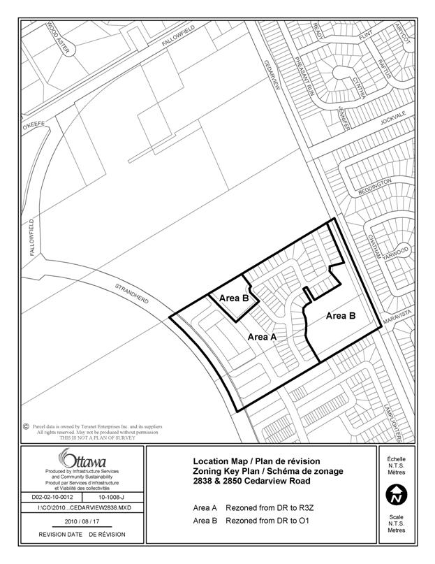
That Council approve an amendment to the Zoning By-law 2008-250 to change the zoning of 2838 and 2850 Cedarview Road from DR- Development Reserve to R3Z – Residential Third Density Subzone Z and O1, Parks and Open Space Zone, as shown in Document 1.
p
RECOMMANDATION DU COMITÉ
Que le Conseil approuve une modification au Règlement de zonage no 2008-250 visant à changer le zonage du 2838 et du 2850, chemin Cedarview, de « DR » (Zone d’aménagement futur) à « R3Z » (Zone résidentielle de densité 3, sous-zone Z) et à « O1 » (Zone de parc et d’espace vert), comme le montre le document 1.
Documentation
1. Deputy City Manager's report Infrastructure Services and Community Sustainability dated 21 September 2010 (ACS2010-ICS-PGM-0160).
Report to/Rapport au :
Planning and Environment Committee
Comité de l'urbanisme et de l'environnement
and Council / et au Conseil
21 September 2010 / le 21 septembre 2010
Submitted by/Soumis par : Nancy Schepers, Deputy City Manager/Directrice municipale adjointe, Infrastructure Services and Community Sustainability/Services d’infrastructure et Viabilité des collectivités
Contact Person/Personne-ressource : Derrick Moodie, Manager/Gestionnaire, Development Review-Suburban Services/Examen des projets d'aménagement-Services suburbains, Planning and Growth Management/Urbanisme et Gestion de la croissance
(613) 580-2424, 15134 Derrick Moodie@ottawa.ca
|
SUBJECT: |
ZONING - 2838 and 2850 Cedarview Road (FILE NO. D02-02-10-0012) |
|
|
|
|
OBJET : |
REPORT RECOMMENDATIONS
That the recommend Council approve an amendment to the Zoning By-law 2008-250 to change the zoning of 2838 and 2850 Cedarview Road from DR- Development Reserve to R3Z – Residential Third Density Subzone Z and O1, Parks and Open Space Zone, as shown in Document 1.
RECOMMANDATIONS DU RAPPORT
Que le Comité de l’urbanisme et de l’environnement recommande au Conseil d’approuver une modification au Règlement de zonage no 2008-250 visant à changer le zonage du 2838 et du 2850, chemin Cedarview, de « DR » (Zone d’aménagement futur) à « R3Z » (Zone résidentielle de densité 3, sous-zone Z) et à « O1 » (Zone de parc et d’espace vert), comme le montre le document 1.
BACKGROUND
The site is located south of Fallowfield Road and bounded by Strandherd Drive on the west and Cedarview Road on the east and has an approximate area of 13.2 hectares.
The parcel is rectangular in shape, generally flat in nature and has been used for farming in the past. There is a watercourse known as the Foster Drain that bisects the property which is to be relocated to the east side of the property abutting Cedarview Road.
Surrounding the subject property, to the south and east are existing residential developments. To the north and west are vacant lands. The lands to the north are to be future residential and to the west, the land is designated as future Prestige Business Park in the Secondary Plan for South Nepean – Areas 9 & 10.
Purpose of Zoning Amendment
The proposed Zoning By-law amendment is required to allow development of a fully serviced residential subdivision in the South Nepean Urban Area.
The existing zoning of the property is DR, Development Reserve which recognizes the lands intended for future urban development.
The proposed zoning is R3Z, Residential Third Density Subzone Z and O1, Parks and Open Space Zone. This will permit a residential development with a park, a stormwater facility and a relocated watercourse to proceed once the subdivision agreement is registered.
DISCUSSION
The Official Plan designates the subject land as General Urban Area. The intent of the General Urban Area designation is to provide for a full range of and a choice of housing types to meet the needs of all. Leisure and greenspace areas are to be provided to support active and passive recreational activities within the development and the community.
The Secondary Plan for South Nepean – Areas 9 & 10 designates these lands as Residential. A variety of housing types including single detached and row dwellings are permitted. There is to be a local park provided within this area. The Jock River Reach One Subwatershed Study identifies that a stormwater management facility is to be provided within these lands to service this and two other plans of subdivision to the north. The Foster Drain is to be relocated to the east side of the development abutting Cedarview Road.
Details of the Proposed Zoning
The applicant is requesting that zoning for 2838 and 2850 Cedarview Road be changed to R3Z, O1 and O1[xxxx], Parks and Open Space Zone [Exception xxxx] to permit development of the lands to proceed.
The R3Z zone will permit the development of single detached and row dwellings. This zone has been used for the developments in this area to the south and will permit a continuation of the established density and character for this neighbourhood in South Nepean.
A review of the requested O1[xxxx] zone determined that this exception zone to permit a 0‑metre setback from the proposed relocated watercourse along the east side of the development abutting Cedarview Road is not required. The setback for the relocated watercourse has been established through a draft approved subdivision condition as required by the Zoning By-law. The approved subdivision condition is as follows:
17. The Owner shall acknowledge that the width of Block 97 is 12.5 metres consisting of a five-metre buffer between the residential lot lines and the top of bank (west side), a 5.5‑metre wide channel for the relocated Foster Drain and a two-metre buffer on the east bank as shown by Maravista Heights Existing Proposal Figure 1 by IBI Group dated January 14, 2010. This shall be to the satisfaction of the Rideau Valley Conservation Authority and the General Manager, Planning and Growth Management Department.
The subdivision application for 2838 and 2850 Cedarview Road was draft approved on April 16, 2010.
Therefore, the proposed park, the stormwater management facility and the relocated watercourse corridor will be zoned O1. This zone will permit the local park and a utility installation (stormwater management facility) and recognize the lands for the relocated watercourse as open space.
This matter has been discussed with the applicant and the applicant supports the proposed O1 zoning for the stormwater management facility and the relocated watercourse lands.
Staff recommends this zoning be approved as it meets the intent of all applicable policies and provides for the continuation of residential development in neighbourhood of South Nepean in an orderly manner.
ENVIRONMENTAL IMPLICATIONS
The Rideau Valley Conservation Authority has reviewed the proposed zoning amendment and finds the O1 zone appropriate for that section of the subdivision block containing the relocated watercourse as the setback from the watercourse is established through a condition of subdivision.
RURAL IMPLICATIONS
N/A
CONSULTATION
Notice of this application was carried out in accordance with the City's Public Notification and Consultation Policy. The City did not receive any negative comments or opposition to this application.
COMMENTS BY THE WARD COUNCILLOR(S)
The Ward Councillor is aware of this application and staff’s recommendation.
LEGAL/RISK MANAGEMENT IMPLICATIONS
There are no legal/risk management implications associated with this report.
CITY STRATEGIC PLAN
In accordance with the City Strategic Plan, this development respects the existing urban fabric and the infrastructure required for this development is to be built as part of the subdivision requirements.
TECHNICAL IMPLICATIONS
FINANCIAL IMPLICATIONS
There are no direct financial implications associated with this report.
APPLICATION PROCESS TIMELINE STATUS
This application was processed by the "On Time Decision Date" established for the processing of Zoning By-law amendment applications.
SUPPORTING DOCUMENTATION
Document 1 Location Map
DISPOSITION
City Clerk and Solicitor Department, Legislative Services to notify the owner, applicant, OttawaScene.com, 174 Colonnade Road, Unit #33, Ottawa, ON K2E 7J5, Ghislain Lamarche, Program Manager, Assessment, Financial Services Branch (Mail Code: 26-76) of City Council’s decision.
Planning and Growth Management to prepare the implementing by-law, forward to Legal Services and undertake the statutory notification.
Legal Services to forward the implementing by-law to City Council.
LOCATION MAP DOCUMENT 1