|
|
COMMITTEE RECOMMENDATIONS
That Council approve the Site Plan Control application for 4899 Uplands Drive as shown on the following plans:
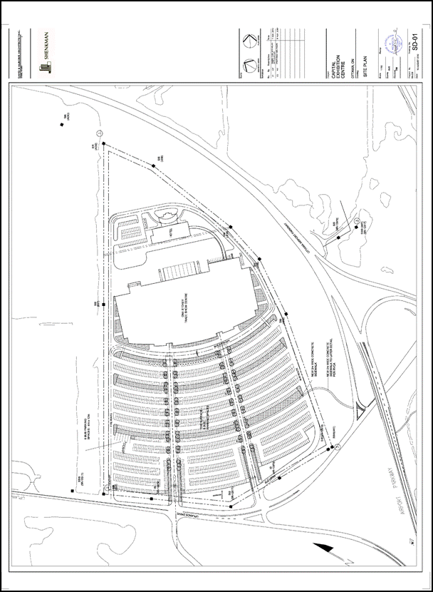
1. Site Plan, Dwg. No. SD-01, dated August 16, 2010, revised September 24, 2010, prepared by David S. McRobie Architects Inc.
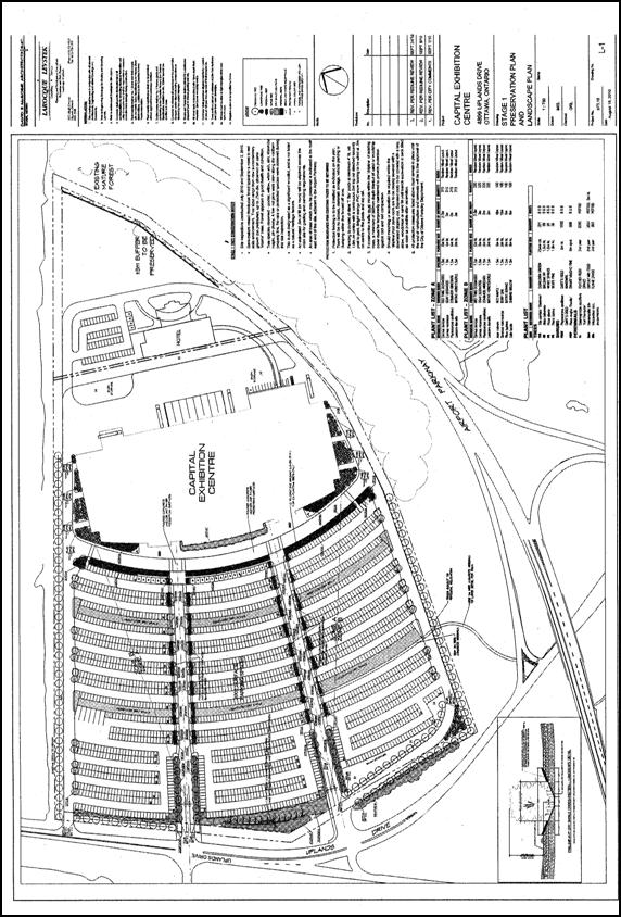
2. Preservation Plan and Landscape Plan, Dwg. No. L-1, dated August 16, 2010, revised September 24, 2010, prepared by Larocque Levstek Consulting Services.
3. Site Servicing and Grading Plan, Dwg. No. SSGP-1, dated August 2010, revised September 24, 2010, prepared by David Schaeffer Engineering Ltd.
4. Erosion Control Plan, Dwg. No. EC-1, dated August 2010, revised September 24, 2010, prepared by David Schaeffer Engineering Ltd.
5. Stormwater Management Plan, Dwg. No. SWM-1, dated August 2010, revised September 24, 2010, prepared by David Schaeffer Engineering Ltd.
6. Forecmain Routing, Dwg. No. PP-1, dated September 2010, revised September 24, 2010, prepared by David Schaeffer Engineering Ltd.
7. Forcemain Routing, Dwg. No. PP-2, dated September 2010, revised September 24, 2010, prepared by David Schaeffer Engineering Ltd.
Subject to the conditions detailed in Document 6.
RECOMMANDATIONS DU COMITÉ
Que le Conseil approuve la demande de réglementation du plan d’implantation pour le 4899, promenade Uplands, comme il est indiqué sur les plans suivants :
1. Plan d’implantation, Dessin no SD-01, en date du 16 août 2010, révisé le 24, septembre 2010 préparé par David S. McRobie Architects Inc.;
2. Plan de préservation et plan d’aménagement paysager, Dessin no L-1, en date du mois d’août 2010, révisé le 24 septembre 2010, préparé par Larocque Levstek Consulting Services;
3. Plan d’implantation des services publics et plan de nivellement, Dessin no SSGP-1, en date du mois d’août 2010, révisé le 24 septembre 2010, préparé par David Schaeffer Engineering Ltd.;
4. Plan de contrôle de l’érosion, Dessin no EC-1, en date du 16 août 2010, révisé le 24 septembre 2010, préparé par David Schaeffer Engineering Ltd.;
5. Plan de gestion des eaux pluviales, Dessin no SWM-1, en date du mois d’août, révisé le 24 septembre 2010, préparé par David Schaeffer Engineering Ltd.;
6. Tracé de la conduite de refoulement, Dessin no PP-1, en date du mois de septembre 2010, révisé le 24 septembre 2010, préparé par David Schaeffer Engineering Ltd.;
7. Tracé de la conduite de refoulement, Dessin no PP-2, en date du mois de septembre 2010, révisé le 24 septembre 2010, préparé par David Schaeffer Engineering Ltd.;
Sous réserve des conditions énoncées en détail dans le Document 6.
Documentation
1. Deputy City Manager's report Infrastructure Services and Community Sustainability dated 23 September 2010 (ACS2010-ICS-PGM-0181).
2. Extract of draft Minutes of 4 October 2010 (Issued separately)
Report to/Rapport au :
Planning and Environment Committee
Comité de l'urbanisme et de l'environnement
and Council / et au Conseil
23 September 2010 / le 23 septembre 2010
Submitted by/Soumis par : Nancy Schepers, Deputy City Manager, Directrice municipale adjointe, Infrastructure Services and Community Sustainability, Services d'infrastructure et Viabilité des collectivités
Contact Person/Personne-ressource : Derrick Moodie, Manager/Gestionnaire, Development Review/Examen des projets d'aménagement, Planning and Growth Management/Urbanisme et Gestion de la croissance
(613) 580-2424, 15134 Derrick.Moodie@ottawa.ca
|
SUBJECT: |
SITE PLAN CONTROL - 4899 uplands drive (FILE NO. d07-12-10-0210) |
|
|
|
|
OBJET : |
REPORT RECOMMENDATIONS
- That Planning and Environment Committee recommend that Council approve the Site Plan Control application for 4899 Uplands Drive as shown on the following plans:
2. Site Plan, Dwg. No. SD-01, dated August 16, 2010, revised September 24, 2010, prepared by David S. McRobie Architects Inc.
3. Preservation Plan and Landscape Plan, Dwg. No. L-1, dated August 16, 2010, revised September 24, 2010, prepared by Larocque Levstek Consulting Services.
4. Site Servicing and Grading Plan, Dwg. No. SSGP-1, dated August 2010, revised September 24, 2010, prepared by David Schaeffer Engineering Ltd.
5. Erosion Control Plan, Dwg. No. EC-1, dated August 2010, revised September 24, 2010, prepared by David Schaeffer Engineering Ltd.
6. Stormwater Management Plan, Dwg. No. SWM-1, dated August 2010, revised September 24, 2010, prepared by David Schaeffer Engineering Ltd.
7. Forecmain Routing, Dwg. No. PP-1, dated September 2010, revised September 24, 2010, prepared by David Schaeffer Engineering Ltd.
subject to the conditions detailed in Document 6.
RECOMMANDATIONS DU RAPPORT
Que le Comité de l’urbanisme et de l’environnement recommande au Conseil d’approuver la demande de réglementation du plan d’implantation pour le 4899, promenade Uplands, comme il est indiqué sur les plans suivants :
1. Plan d’implantation, Dessin no SD-01, en date du 16 août 2010, révisé le 24, septembre 2010 préparé par David S. McRobie Architects Inc.;
2. Plan de préservation et plan d’aménagement paysager, Dessin no L-1, en date du mois d’août 2010, révisé le 24 septembre 2010, préparé par Larocque Levstek Consulting Services;
3. Plan d’implantation des services publics et plan de nivellement, Dessin no SSGP-1, en date du mois d’août 2010, révisé le 24 septembre 2010, préparé par David Schaeffer Engineering Ltd.;
4. Plan de contrôle de l’érosion, Dessin no EC-1, en date du 16 août 2010, révisé le 24 septembre 2010, préparé par David Schaeffer Engineering Ltd.;
5. Plan de gestion des eaux pluviales, Dessin no SWM-1, en date du mois d’août, révisé le 24 septembre 2010, préparé par David Schaeffer Engineering Ltd.;
6. Tracé de la conduite de refoulement, Dessin no PP-1, en date du mois de septembre 2010, révisé le 24 septembre 2010, préparé par David Schaeffer Engineering Ltd.;
7. Tracé de la conduite de refoulement, Dessin no PP-2, en date du mois de septembre 2010, révisé le 24 septembre 2010, préparé par David Schaeffer Engineering Ltd.;
Sous réserve des conditions énoncées en détail dans le Document 6.
BACKGROUND
Site Location:
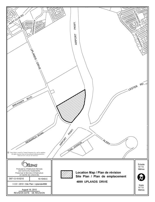
The subject site is located at the northeast intersection of Uplands Drive and the Airport Parkway, north of Alert Road on the Macdonald Cartier International Airport property.
Description of Site and Surroundings:
The subject site is irregular in shape and has an area of 34 acres, with frontage along Uplands Drive of 345 metres, and a lot depth of 398 metres. The site is currently a vacant wooded lot. To the north and east of the site are vacant wooded lots. To the southeast on Lester Road is the National Research Council of Canada. To the south on Alert Road is a recently constructed Hilton Garden Inn.
Purpose of Site Plan Control Proposal:
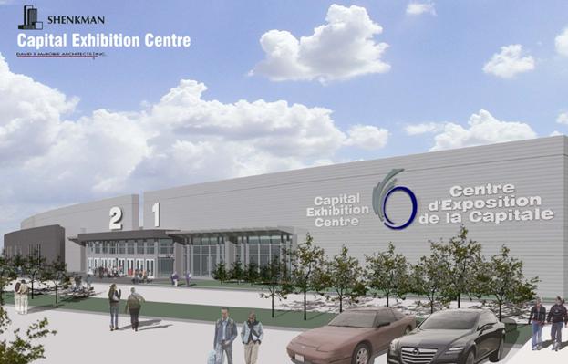
The purpose of this application is to obtain site plan control approval for the development of a new exposition hall and hotel.
Proposal Details:
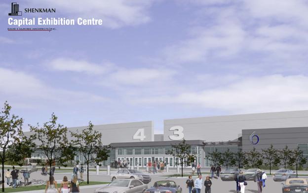
The application proposes to develop a one-storey 218,000 square foot exposition hall which will consist of 150,000 square feet of exhibition space and 68,000 square feet of service and common area space as shown on Document 2. The application also proposes to construct a 90-room hotel on the eastern portion of the site which would be connected to the exposition hall via an enclosed walkway. The proposed maximum building height for the exposition hall is ten metres. Vehicular access to the site will be from Uplands Drive with three new controlled access points. The most northerly approach would function as the access point for delivery and service vehicles that would ultimately need to arrive to the rear of the building where loading and service bays are located. The two remaining access points would service car and bus traffic. The pedestrian entrances to the hall are to be located on the west side of the building. Approximately 2,003 surface parking spaces are proposed for the facility along with a series of new internal sidewalks.
The application has been revised from the original submission to now include a pedestrian link from the Airport Parkway onto the site, the introduction of an internal OC Transpo bus loop, additional landscaping along the southern limit of the property and within the parking lot, and a reduction in the amount of vehicle parking.
The subject application has been processed under delegated authority; however as a result of delegated authority having been lifted, and in accordance with motion approved by City Council on September 22, 2010, the determination of application for site plan approval for the Exposition Hall Facility will be vested in Council.
DISCUSSION
Official Plan
The subject property is designated as Macdonald Cartier International Airport on Schedule B of the Official Plan. On lands designated Ottawa Macdonald–Cartier International Airport uses such as a civilian or military airport, hotel and related commercial uses along with uses permitted within Employment Areas are permitted. The Official Plan further provides that the consideration of land uses on airport lands will be based upon the Ottawa Macdonald-Cartier International Airport Authority Land-Use Plan.
2008 Airport Master Plan
The subject property is designated as “Commercial Aviation / Non-aviation Employment Area” on the 2008 Airport Master Plan. The Land Use Plan is an expression of the intent for future growth and development of airport lands over the planning period 2008 to 2030. The Plan is a Federal-Minister-approved development strategy that guides the future growth of the airport which is not subject to further approvals, however the Plan integrates, to the extent practical and appropriate, the policy and regulatory context within which it resides.
The purpose of the Airport Master Plan is to ensure that rational and orderly development is achieved for the Airport through the designation of an appropriate mix and distribution of aviation and non-aviation commercial, industrial and other employment uses. The “Commercial Aviation/Non Aviation Employment area designation applicable to the subject site allows for the establishment of both aviation and non aviation related commercial, light industrial and employment uses. The intent of the designation is to provide the Airport with flexibility in the development of the lands for aviation related or non-aviation uses. This broad designation allows for a wide mix of uses typically associated with airports and uses typically characteristic of business parks and community orientated commercial areas such as offices, research and development, personal service establishments, athletic and indoor recreational centres and retail establishments.
The proposed exhibition hall and hotel use is consistent with the range of uses as envisioned within the Macdonald Cartier International Airport designation in the City’s Official Plan and the Commercial Aviation/Non Aviation Employment area designation in the Airport Master Plan.
Compatibility and Design
The policies for compatibility within Section 2.5.1 of the Official Plan set out Design Objectives and Principles pertaining to compatibility. The Design Objectives are qualitative statements and are broadly stated. Principles then describe how the City hopes to achieve each of the Design Objectives but may not be achieved or be achievable in all cases. The proposed development is consistent with the intent of the Design Objectives and Principles as discussed below:
Enhance the sense of community by creating places with their own identity: The development proposal will help introduce a built presence along the Airport Parkway which is identified as a “Capital Arrival Route” in the 2008 Airport Master Plan and ‘Buildable Area” NCC Greenbelt Master Plan, 1996. The proposal will help to continue the evolving pattern of development in the immediate area.
Creating safe, accessible places, which are easy to get to: Pedestrian access to the exhibition hall will be improved with new connections from the existing transit stops along the Airport Parkway onto the site. An internal walkway system will separate pedestrians from internal traffic and safely direct patrons into the exhibition hall. The site has also been designed to accommodate the movement of OC Transpo buses.
Section 4.11 of the Official Plan provides further criteria to access compatibility during the review of development applications dealing with matters such as traffic impacts, vehicular access, lighting and supporting neighbourhood services. The proposed development has been assessed relative to the applicable criteria and responds to the various matters to be addressed to ensure compatibility.
- Access to the property will be from Uplands Drive, a collector roadway, via three new driveway connections. The middle access point, which aligns with Research Road to the west, will be a full movement signalized intersection and service automobile traffic. The most southerly access point will be a full movement non-signalized intersection and provide access for automobile traffic and a designated route for OC Transpo buses to enter the site and circulate through the site and exit at the northern limit. The most northern access point will be a full movement non-signalized intersection which will service delivery vehicles and OC Transpo buses existing site.
- Loading and service areas to serve the development will be screened from the street by the mass of the building and additional landscaping. There is no outdoor storage proposed.
- Lighting spill over and design will be addressed through the preparation of a Site Lighting Certificate to ensure there is no off-site bleeding onto abutting properties and that the impacts of lighting on the surrounding area is minimized.
- The property can be adequately serviced by water, sanitary and storm sewer facilities to support the extent of the proposed redevelopment.
Zoning By-law Requirements
The subject property is designated “T1A” Macdonald-Cartier International Airport subzone. The intent of the TIA zone is to permit air transportation facilities and aviation-related uses in areas designated as Ottawa Macdonald-Cartier International Airport and Carp Airport in the Official Plan, and to permit a range of employment uses and airport-related commercial and industrial uses at the Ottawa Macdonald-Cartier International Airport.
The T1A subzone permits a variety of uses including but not limited to a research and development centre, bank, hotel, museum, office, restaurant and training centre. A place of assembly is permitted provided that it is located in a building containing an airport passenger terminal or a hotel.
An application for a minor variance (file D08-02-10/A/00266) was submitted by the Owner to permit a “place of assembly” to be located in a building that does not contain an airport passenger terminal or hotel. The requested variance was approved on September 15, 2010. As the minor variance approval will not be final and binding before October 12, 2010, Special Condition 1 has been included in the approval to allow for the phased construction of the project starting with the exhibition hall as the first phase, and a hotel to follow.
Summary
The proposed site plan control application has been reviewed in relation to the applicable policies of the Official Plan, Airport Master Plan and the Zoning By-law and it is the Department’s opinion that the application merits approval.
ENVIRONMENTAL IMPLICATIONS
Natural Heritage – Wetlands:
A Wetland Evaluation was conducted in 2009 by Beacon Environmental for the City Ottawa, which included the subject property within the study area. The study concluded that the subject site does not meet the criteria for designation as a Provincially Significant Wetland (PSW). The report will be submitted to the Ministry of Natural Resources for review and consideration; however at this time the subject property is not designated as a Provincially Significant Wetland and is not within the 120-metre adjacent lands of a designated PSW.
The Rideau Valley Conservation Authority (RVCA) does not have regulatory jurisdiction on this property relating to wetlands or adjacent lands under Ontario Regulation 174/06 (Development, Interference with Wetlands and Alterations to Shorelines and Watercourses Regulation) as the subject property is Federally controlled.
Natural Heritage – Watercourses and Fish Habitat:
The RVCA has identified three interconnected watercourses on the subject property which convey flows passing through two culverts under the Airport Parkway and ultimately downstream to Sawmill Creek. The catchment areas for these watercourses includes the subject site and lands to the north and west. Normally, watercourses such as these are subject to the “Development, Interference with Wetlands and Alteration to Shorelines and Watercourses Regulation (Ontario Regulation 174/06 under Section 28 of the Conservation Authorities Act), as administered by the Rideau Valley Conservation Authority. Written approval of the Conservation Authority is required prior to straightening, changing, diverting or interfering in any way with the channel of the watercourse. However, on Federal Lands, the approval of the RVCA is not required for alterations (including the installation of the stormwater outlets) or the closing of watercourses.
Based on observations from RVCA staff and field work undertaken by others, the aforementioned watercourses have been determined at this time to be fish habitat. An additional field assessment has concluded that the subject site may require Level 2 approvals. The RVCA has been involved in the review of the fisheries aspect of the application in their role as the local delivery agent for the Federal Fisheries Act. Staff anticipates an update from the RVCA to be presented at the October 4, 2010 Planning and Environment Committee meeting. Special Condition 2 has been included to satisfy this requirement.
The site development will involve the removal of existing vegetation on site. The applicant has prepared a Tree Preservation and Landscape Plan for the subject property which details the protective measures to be implemented during construction.
RURAL IMPLICATIONS
N/A
CONSULTATION
Notice of this applicaton was carried out in accordance with the City's Public Notification and Consultation Policy. Detailed responses to the notification/circulation are provided in Document 6.
COMMENTS BY THE WARD COUNCILLOR(S)
I would like to submit the following formal comments on the site plan application at 4899 Uplands Drive. I object to the site plan application for the following reasons:
1) I do not support development within our greenbelt.
2) Please provide me with proof that 4899 Uplands Drive is not a wetland.
3) What is the effect of an increased and consistent volume of traffic from this Trade Show facility on Albion Road, Lester Road, Uplands Drive, and the Airport Parkway? Traffic volumes at peak hours appear to be over capacity for Albion Road at Lester Road as well as the Airport Parkway. What does the applicant propose to do to enhance traffic flow in these areas? What does the applicant propose to do to mitigate traffic volumes for Uplands Drive (from Hunt Club Road to the Airport Parkway) as the 2000+ parking spaces and Trade Show building face directly onto Uplands Drive?
4) I would like to request a peer review of the applicant's Transportation Analysis.
5) As a result of the September 15, 2010 Committee of Adjustment decision to grant a minor variance to the applicant, (eliminating the requirement for a new hotel be attached to this proposed facility) I request that the applicant provide an underground or covered safe pedestrian link from a proposed Trade Show facility to the existing hotel.
6) I request sidewalks, appropriate transit stops, shelter and pads around any proposed facility.
7) I request appropriate task oriented lighting in the area of any proposed facility.
8) I request a Tree Preservation Plan Analysis be done to determine if there are any sensitive species such as Butternut trees on site. I am concerned that there are also wildlife species of interest in the area such as Blanding's turtles, and Snapping turtles which would be at risk if development were to occur. I would like more information on what wildlife exists on this land and in the area, and what impact this project will have on their habitat.
I am supportive of a new home for Exposition / Trade Shows, but not at the expense of the environment.
A staff response to the Councillors comments can be found in Document 6.
LEGAL/RISK MANAGEMENT IMPLICATIONS:
As a matter under the Planning Act, Council retains the discretion to seek to impose conditions under the authority granted to Council pursuant to the Planning Act, Section 41. In the event that the Applicant is of the view that such conditions are not warranted, such conditions may be referred to the Ontario Municipal Board. Only an applicant may refer a site plan or the related conditions to the Board.
The costs involved in such a hearing would depend upon the matters referred to the Board.
CITY STRATEGIC PLAN
The proposed development is consistent with the Planning and Growth Management objective to invest in programs and initiatives that improve Ottawa’s business climate, support job creation and enhance the City’s social and economic prosperity. The proposed development is also consistent with the Solid Waste and Environment objective of increasing waste diversion as per Special Condition 16, which requires the Owner to operate the facility in accordance with leading waste diversion strategies, including source separated organics.
TECHNICAL IMPLICATIONS
Roadway modifications will be required as recommended by the approved traffic impact study. The Owner will be required to obtain a Roadway Modification Approval to the satisfaction of the City of Ottawa.
FINANCIAL IMPLICATIONS
On 29 June, 2010 as part of its special meeting stating on 17 June 2010, Council approved a Memorandum of Understanding between the City and Shenkman Corporation (“Shenkman”) and authorized the City Manager to negotiate and execute a Project Agreement and associated Municipal Capital Facility Agreement with Shenkman Corporation for the design, construction, operation, and financing of the proposed Exposition Hall Facility (“the Agreements’).
The Conditions of Site Plan Approval as set out in Document 5 of this report are consistent with the provisions of the Agreements and will not result in additional cost to the City under the Agreements.
APPLICATION PROCESS TIMELINE STATUS
The application was processed by the "On Time Decision Date" established for the processing of Site Plan Control applications in which Delegation of Authority to the Director of Planning and Infrastructure Approvals is removed.
SUPPORTING DOCUMENTATION
Document 4 - Conditions of Site Plan Control Approval
Document 5 – Building Elevations
Document 6 - Consultation Details
DISPOSITION
Legal Services to prepare the Site Plan Control agreement.
Planning and Growth Management to notify the owner, applicant, architect, all registered speakers, OttawaScene.com, 174 Colonnade Road, Unit #33, Ottawa, ON K2E 7J5, of Planning and Environment Committee’s decision.
LOCATION MAP DOCUMENT 1
 |
SITE PLAN DOCUMENT 2
LANDSCAPE PLAN DOCUMENT 3
BUILDING ELEVATIONS DOCUMENT 4
CONDITIONS OF SITE PLAN CONTROL APPROVAL DOCUMENT
5
STANDARD CONDITIONS
1. Permits
The Owner shall obtain such permits as may be required from Municipal or Provincial authorities and shall file copies thereof with the General Manager, Planning & Growth Management Department.
2. Water Supply for Fire Fighting
The Owner shall provide adequate water supply for fire fighting for every building. Water supplies may be public water works system, automatic fire pumps, pressure tanks or gravity tanks.
3. Reinstatement of City Property
The Owner shall reinstate at its expense, to the satisfaction of the General Manager, Planning & Growth Management Department, any property of the City, including, but not limited to, sidewalks and curbs, boulevards, that are damaged as a result of the subject development.
4. Construction Fencing
The Owner shall be required to install construction fencing at its expense, in such a location as may be determined by the General Manager, Planning & Growth Management Department.
5. Completion of Works
No building will be occupied on the lands, nor will the Owner convey title to any building until all requirements with respect to completion of the Works as identified in this Agreement have been carried out and received Approval by the General Manager, Planning & Growth Management Department, including the installation of municipal numbering provided in a permanent location visible during both day and night and the installation of any street name sign on relevant streets. Provided that notwithstanding the non-completion of the foregoing Works, conveyance and/or occupancy of a lot or structure may otherwise be permitted, if in the sole opinion of the General Manager, Planning & Growth Management Department, the aforesaid Works are proceeding satisfactorily toward completion. The Owner shall obtain the consent of the General Manager, Planning & Growth Management Department for such conveyance and/or occupancy in writing.
SPECIAL CONDITIONS
1. Final Plans
That the finalization of all required drawings, including, but not limited to the Site Plan, Landscape Plan, Site Servicing Plan and the Grading Plan, and of all related required conditions of approval, shall be to the satisfaction and approval of the General Manager, Planning and Growth Management Department.
Upon such time that application D08-02-10/A/00266 becomes final and binding with all appeal mechanisms exhausted, the plans recommended for approval may be revised to remove the hotel component, to the satisfaction of the General Manager, Planning and Growth Management. Should the variance application be withdrawn, the Owner agrees to obtain a building permit for a hotel within five (5) years of the issuance of an occupation permit for a place of assembly.
2. Watercourse Mitigation and Compensation
The Owner acknowledges that fish have been found within the watercourses on the subject property and that mitigation measures/compensation may be required. The level of work to meet these requirements are dependant of the impact of this development. At a Level 2 approval, the Rideau Valley Conservation Authority (RVCA) has delegated authority to approve the necessary works. It is intended to confirm the level of work will fall under a Level 2 approval, and concurrence from the RVCA will be provided at the Planning & Environment Committee meeting on October 4, 2010. No construction in water courses identified as fish habitat is permitted until the recommended works are approved by the RVCA and the City of Ottawa are implemented.
The Owner agrees to provide the required mitigation/compensation measures necessary to satisfy the RVCA and the General Manager, Planning and Growth Management Department. The Owner will be responsible for all associated costs to implement said works and to obtain all necessary permits required to complete such works.
The City of Ottawa accepts that the mitigation/compensation measures may occur in the Airport Parkway Right-of-Way and will work with the Owner to finalise the extent of the area required to implement said measures.
The Owner acknowledges that in the event the fish habitat is classified as a Level 3 designation, the Owner will be required to seek the necessary approvals of the Department of Fisheries and Oceans prior to the City of Ottawa issuing Site Plan Control approval.
3. Traffic Impact Study
The Owner has undertaken a Transportation Impact Study certified by a Professional Engineer with expertise in undertaking such studies which complies with the City of Ottawa’s Transportation Impact Study Guidelines in identifying Transportation Demand Management measures and analyzing traffic impacts, transit impacts and implications for pedestrian and bicycle movements. The Owner agrees to implement the recommendations of this study at their cost.
4. Public Roadway Modifications
The Owner shall pay all expenses including but not limited to land acquisition, contract drawings preparation, utility relocations, advertising, road work, traffic signal lights installation, construction supervision, as built drawing preparation, and other engineering and administrative costs for the modification of any intersection(s) and installation of traffic signals as recommended by the approved Traffic Impact Study noted in Condition 3. All roadway modification works and installation of traffic control signals will require the delegated authority approval from the Manager of Development Review.
5. Traffic Signal Agreement
The Owner shall be required to enter into a Traffic Signal Agreement with the City of Ottawa to provide for the ongoing maintenance of traffic signals at the Research Road and Uplands Drive intersection until such time as the Ministry of Transportation’s traffic signal warrants are met and City Council approves the assumption of these costs.
6. Street Signs
The Owner shall be responsible for 100% of the cost and installation of all permanent and temporary street name signs and traffic signs that may be required in accordance with City specifications. All signs shall be installed and located to the satisfaction of the City and installed prior to the City’s acceptance of the roads within the subdivision.
7. Future Transit Ramp
The Owner acknowledges that a future dedicated transit ramp from the Airport Parkway onto the subject site may be required in an effort to increase the efficiency and access of transit service on site. In the event the transit ramp is required, the Owner shall be responsible for 100% of the costs.
8. OC Transpo
The Owner(s) shall locate, design and construct, at no cost to the City of Ottawa, paved transit passenger standing areas/shelter pads and shelters to the specifications of the City of Ottawa.
9. Sidewalks
The Owner shall be responsible to design and construct sidewalk(s) within public right-of-ways or on other City owned lands (to provide a pedestrian connection from or to the site) as may be determined by the General Manager, Planning & Growth Management Department. Such sidewalk(s) shall be constructed to City Standards.
10. Geotechnical Report
The Owner’s Geotechnical Engineer shall ensure that the recommendations of the Geotechnical Investigation, Report No. PG2073-1, prepared by Patterson Group Inc., are fully implemented and provide certificates of compliance, with respect to all recommendations and provisions of the report, prior to construction of the foundation and at the completion of the works, to the satisfaction of the General Manager, Planning and Growth Management Department.
11. Site Lighting Certificate
Prior to the Site Plan Approval, the applicant shall provide a certificate, from an acceptable professional engineer, that the site lighting has been designed to meet the following criteria:
a. It must be designed using only fixtures that meet the criteria for Full Cut-Off (Sharp cut-off) Classification, as recognized by the Illuminating Engineering Society of North America (IESNA or IES), and;
b. It must result in minimal light spillage onto adjacent properties. As a guideline, 0.5 fc is normally the maximum allowable spillage.
Upon completion of the works, the applicant must provide certification satisfactory to the City that the site lighting has been constructed in accordance with the applicant’s design prior to the City releasing any associated securities.
12. Waste Collection
Waste collection and recycling collection will not be provided by the City. The applicant should make appropriate arrangements with a private contractor for waste and recycling collection. The Owner should consult a private contractor regarding any access requirements for waste and/or recycling collection.
13. License of Occupation
Prior to registration of this agreement, the Owner shall enter into an agreement with the City for a License of Occupation that covers the maintenance and liability of the proposed private 100mm diameter sanitary forcemain on Uplands Drive, from the subject site to the intersection of Downpatrick Road.
14. Decommissioning of On-site Monitoring Wells
The Owner agrees to remove/decommission any on-site monitoring wells, if not required for future groundwater monitoring purposes, in accordance with O.Reg. 903 (as amended), under the Ontario Water Resources Act.
15. Dry Swale Drainage System
The Owner shall develop a monitoring program to confirm the level of sediment control being accomplished, extent of water quality of the surface water leaving as per the Rideau Valley Conservation Authority (RVCA) targets, and the extent of the groundwater recharge occurring for this site. The monitoring program is to be reviewed and approved by the RVCA and the General Manager, Planning and Growth Management Department. The Owner shall implement the approved monitoring program for a period of five (5) years and provide annual monitoring results. The Owner shall be responsible for all costs related to developing and implementing the monitoring program and for any site improvements necessary to meet RVCA targets.
16. Waste Diversion
The Owner agrees that the facility shall be operated and maintained in accordance with leading waste diversion strategies, including source separated organics. The implementation of any waste diversion strategies and operational requirements will be at the Owners expense.
17. Tree Protection Measures
The following mitigation measures for retained trees as per the Tree Conservation Report Guidelines shall be implemented during all construction on site:
· Erect a fence at the critical root zone (CRZ) of trees;
· Do not place any material or equipment within the CRZ of the tree;
· Do not attach any signs, notices or posters to any tree;
· Do not raise or lower the existing grade within the CRZ without approval;
· Tunnel or bore when digging within the CRZ of a tree;
· Do not damage the root system, trunk or branches of any tree;
· Ensure that exhaust fumes from all equipment are NOT directed towards any tree's canopy.
The critical root zone is established as being 10 centimetres from the trunk of a tree for every centimetre of trunk diameter at 1.2 m above the ground. It is calculated as diameter in cm X 10. Prior to tree removal, the City Planning Forester shall be contacted to set up a site inspection the site and ensure that the appropriate mitigations measures are in place and that the boundaries for tree removal have been properly marked.
18. Emerald Ash Borer
Compliance with the Ministerial Order issued by the Canadian Food Inspection Agency prohibiting the movement of any ash material and firewood of all species of ash trees from the Ottawa area. Those ash trees which are removed from the above-noted address must be disposed of in accordance with the City of Ottawa Guidelines attached hereto and which can also be found on the following website: http://ottawa.ca/residents/healthy_lawns/forestry/eab/ash_removal_en.html
19. Watercourse Relocation
The Owner agrees that a plan shall be submitted to the Rideau Valley Conservation Authority (RVCA) showing a relocated watercourse with natural channel design and fish habitat features which mitigate the impacts of the watercourse closings on the site by providing new fish habitat opportunities. This plan shall be prepared by qualified professionals and shall be to the satisfaction of the RVCA.
20. RVCA Permits
The Owner shall apply for and receive a permit from the RVCA under O.Reg 174/06 or a Letter of Advice (LOA) for the installation of the stormsewer outlets and the closure of the watercourses on the site prior to undertaking any works affecting those watercourses. This process shall review for impacts on fish habitat under the requirements of the Department of Fisheries and Oceans.
21. Stormwater Monitoring
The Owners agrees that the stormwater system operation, maintenance and monitoring programs shall be undertaken by the property Owners in accordance with recommendations contained in the final stormwater management report.
CONSULTATION DETAILS DOCUMENT 6
NOTIFICATION AND CONSULTATION PROCESS
Notification and public consultation was undertaken in accordance with the Public Notification and Public Consultation Policy approved by City Council for Site Plan Applications. Four letters were received as a result of the public notification process.
SUMMARY OF PUBLIC INPUT
1. Concerns were raised with respect to the need for new sidewalks to be constructed to connect to existing transit.
Response:
As shown on Document 2, a new pedestrian connection will be located in the southern corner to create a link from the existing OC Transpo Route 97 and 99 stop on the north side of the Airport Parkway onto the site. As well, through the roadway modification approval, the Owner will be required to design and construct a new pedestrian connection from the subject lands to the existing northbound OC Transpo stop abutting the existing hotel. Special Conditions 8 and 9 address the required sidewalk improvements.
2. Concerns were raised with respect to the subject development having not complied with the Canadian Environmental Assessment Act (CEAA) as the property falls on lands owned by the Federal Government.
Response:
Staff have confirmed with Airport Authority staff that the subject lands are exempt from the CEAA process. The Rideau Valley Conservation authority has delegated authority regarding the protection of fish habitat and has been involved in the review of the application and the preparation of appropriate site plan conditions.
3. Concerns were raised with respect to traffic impacts as a result of the proposed development.
Response:
A Traffic Impact Study (TIS) was prepared in support of the application. The recommendations put forward through the TIS were reviewed and approved by staff. The implementation of the approved recommendations will be addressed through Special Conditions 3 to 6.
NATIONAL CAPITAL COMMISSION
The National Capital Commission (NCC) has provided preliminary comments based on their review of the Site Plan Control application. The property has been identified as being located within the “Buildable Area” designation of the NCC Greenbelt Master Plan, 1996. The NCC suggests that signage should be high-quality, halo-lit or down-lit signs with attention to detail. The NCC does not endorse back-lit rooftop signage. The exterior parking area lighting should be limited to the minimum required for safety. Fixtures should be high efficiency, full cut-off metal halide lamps.
ADVISORY COMMITTEE COMMENTS
The Pedestrian and Transit Advisory Committee (PTAC) in a memorandum dated September 17, 2010 recommended the following:
1. PTAC expresses its concerns to the City Staff responsible for the site plan approval and to Councillors regarding the serious inconsistencies between this site and proposal versus the objectives of the Official Plan. Alternative, more accessible locations, better served by public transit and not destroying valuable trees and greenspace be considered.
2. That if the project proceeds at this location, PTAC requests that the site plan be modified to move the Trade and Convention Building to the front of the site, as close as possible to Uplands Drive in order to minimize walking and cycling distances to the site from the #97 bus stops. This is to minimize the visual impact of a large surface parking lot, highly visible to visitors coming to Ottawa from the Airport/Airport Parkway for the first time, and to reduce or eliminate the distance that pedestrians and cyclists must do to get through the currently situated parking lot.
3. If the project proceeds with no major changes to the site plan, that the developer be required to construct a multi-use path along Uplands Drive from Hunt Club to the Airport Parkway/Lester Road, and that the developer develop and permit pedestrian and cycling access to the site directly from the Airport Parkway, immediately to the east to avoid a pedestrian and cycling detour of over 1 km to reach the site.
Response to comments:
The subject property will be screened from traffic moving south along the Airport Parkway toward the intersection of Uplands Drive and the Airport Parkway by the existing vegetation which is to be retained and additional landscaping. The site plan as shown on Document 1 has included a new pedestrian connection from the Airport Parkway onto the site. As noted above, Special Conditions 8 and 9 will address pedestrian connectivity.
Ottawa Forests and Greenspace Advisory Committee (OFGAC)
City of Ottawa staff will be making a presentation to the Ottawa Forests and Greenspace Advisory Committee on September 27, 2010, upon which time final comments from the OFGAC will be requested. Preliminary comments have been provided by OFGAC which has not taken into consideration the information to be presented and the most recent tree preservation and landscape plan and as such the City will respond to the Committee comments after the September 27, 2010 presentation.
RESPONSE TO COUNCILLORS COMMENTS
In response to Point 2 raised, the Environmental Implications section of the report responds to the concern of the subject site being reviewed and potentially designated as a wetland. With respect to Point 3, a Traffic Impact Study was prepared in support of the application and approved by staff. Through the Roadway Modification Approval process, the Owner will implement all recommendations of the approved report and design and construct all roadway modifications to the satisfaction of the City of Ottawa. With respect to the performance of the intersections studied a traffic “LoS D or better” is achieved for most of the intersections. Point 5, requests the provision for an underground or covered pedestrian link from the Trade Show facility to the existing hotel, as the existing hotel on Alert Road is not part of the subject application, such a connection is outside the abilities of Section 41 of the Planning Act. Special Conditions 8 and 9 address the requirement for the Owner to construct new sidewalks and bus shelters to connect existing stops with the subject property and provided improved pedestrian connections to other stops. Standard Condition 11 will require the Owner to provide a sight lighting certificate to address issues such as lighting spillover and design. With respect to Point 8, the applicant has prepared a Tree Preservation and Landscape Plan. The landscape architect for the applicant conducted a site visit earlier this month to confirm the presence of any significant tree species such as Butternut. During the site visit, Butternut was not found on site.