|
7. ZONING - 4030 AND 3853 CAMBRIAN ROAD
ZONAGE - 4030 ET 3853, CHEMIN CAMBRIAN
|
Committee recommendation
(This matter is subject to Bill 51)
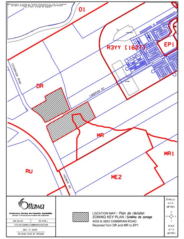
That Council approve an amendment to the Zoning By-law 2008-250 to change the zoning of part of the properties at 4030 and 3853 Cambrian Road from DR (Development Reserve Zone) and MR (Mineral Aggregate Reserve Zone) to EP1 (Environmental Protection Zone, Subzone 1), as shown in Document 1 and detailed in Document 2.
Recommandation DU Comité
(Cette question est assujettie au Règlement 51)
Que le Conseil approuve une modification au Règlement de zonage 2008-250 visant à faire passer la désignation de zonage d’une partie des propriétés portant les adresses municipales 4030 et 3853, chemin Cambrian, de DR (zone d’aménagement futur) et MR (zone de réserve de granulat minéral) à EP1 (zone de protection de l’environnement, sous-zone 1), comme l’illustre le document 1 et le précise le document 2.
Documentation
1. Deputy City Manager's report Planning, Transit and the Environment dated 17 February 2010 (ACS2010-ICS-PGM-0049).
Report to/Rapport au :
Planning and Environment Committee
Comité de l'urbanisme et de l'environnement
and Council / et au Conseil
17 February 2010 / le 17 février 2010
Submitted by/Soumis par : Nancy Schepers, Deputy City Manager/Directrice municipale adjointe,
Infrastructure Services and Community Sustainability/Services d’infrastructure et Viabilité des collectivités
Contact Person/Personne-ressource : Michael Wildman, Manager/Gestionnaire, Development Review-Suburban Services/Examen des projets d'aménagement-Services suburbains, Planning and Growth Management/Urbanisme et Gestion de la croissance
(613) 580-2424, 27811 Mike.Wildman@ottawa.ca
|
SUBJECT: |
|
|
|
|
|
OBJET : |
REPORT RECOMMENDATION
That the recommend Council approve an amendment to the Zoning By-law 2008-250 to change the zoning of part of the properties at 4030 and 3853 Cambrian Road from DR (Development Reserve Zone) and MR (Mineral Aggregate Reserve Zone) to EP1 (Environmental Protection Zone, Subzone 1), as shown in Document 1 and detailed in Document 2.
RECOMMANDATION DU RAPPORT
Que le Comité de l’urbanisme et de l’environnement recommande au Conseil d’approuver une modification au Règlement de zonage 2008-250 visant à faire passer la désignation de zonage d’une partie des propriétés portant les adresses municipales 4030 et 3853, chemin Cambrian, de DR (zone d’aménagement futur) et MR (zone de réserve de granulat minéral) à EP1 (zone de protection de l’environnement, sous-zone 1), comme l’illustre le document 1 et le précise le document 2.
BACKGROUND
The subject lands extend easterly along the north and south side of Cambrian Road and are bounded on the west by Cedarview Road. The property is covered with mature trees and is located within an area commonly referred to as the ‘Cambrian Road Woods’ or Urban Natural Feature (UNF) Site #57. The parcel located north of Cambrian Road encompasses approximately 8.73 hectares. The parcel located south of Cambrian Road contains an area of approximately 11.03 hectares. The surrounding uses include a sand and gravel pit located to the south and agricultural lands located to the north and west of the lands. Cambrian Road is an arterial road, which provides frontage to both parcels.
Cambrian Road Woods, UNF Site #57 is under development pressure as urban residential development is moving towards it from the east. The Planning and Growth Management Department has placed a high priority on the acquisition of this woodlot. On January 19, 2010 the Corporate Services and Economic Development Committee approved a land exchange with the current owner to acquire the Cambrian Woodlot UNF Site #57. This subsequently was approved by City Council on January 27, 2010. The proposed zoning amendment will implement a condition of the land exchange agreement to protect the woodlot from development.
DISCUSSION
The subject lands are designated Urban Natural Feature (UNF) in the Official Plan. The intent of this designation is to preserve significant natural features and associated ecological functions for the long term. The subject lands were examined and evaluated through the Council approved Urban Natural Features Environmental Evaluation Study (March 2005 and 2006) and received a rating of high environmental value, confirming its local environmental significance.
The woodlot has been identified as an Urban Natural Area Designated Woodlot in the Barrhaven South Community Design Plan (2006) and in the Jock River Reach 1 Subwatershed Study (2007). The intent is to retain this area in a nature state. Only passive recreation activities such as trails and orientation areas will be permitted in the Woodlot land use category. The woodland is also included in the Council approval Greenspace Master Plan (June 2006) and is a component of the City’s natural lands inventory and connected Greenspace Network.
Purpose of Zoning Amendment
The purpose of the zoning amendment is to rezone the property for environmental protection.
The current zoning is DR (Development Reserve Zone) and MR (Mineral Aggregate Reserve Zone) under Zoning By-law 2008-250.
The requested zoning amendment proposes to rezone a part of the properties at 4030 and 3853 Cambrian Road from DR and MR to EP1 (Environmental Protection Zone, Subzone 1) for environmental protection. Environmental Protection Zone, Subzone 1 would permit environmental preserve and education area, forestry operation and utility installation.
The proposed zoning will implement the intent of the Community Design Plan to preserve the woodlot. The Environmental Protection Zone, Subzone 1 would permit environmental preserve and education area, forestry operation and utility installation. The Official Plan permits utility installation in Urban Natural Features subject to a study. Given the future urban nature of the woodlot, all of the proposed uses may be necessary to some extent. For example, forestry management activities to remove hazardous trees, establish trails or some minor infrastructure and utility work may be necessary for health and safety reasons such as sanitation, lighting, and emergency access. The extent of the uses will be determined by a Woodlot Management Plan.
ENVIRONMENTAL IMPLICATIONS
As outlined in the Official Plan, Section 3.2.3 any future application for development or site alteration within 30 metres of the boundary of a designated Urban Natural Feature will require an Environmental Impact Statement (EIS), in accordance with the requirement of Policy 4.7.8. The Land Exchange Agreement has specified that the EIS must explicitly consider the impacts of the development or site alteration on the UNF and the Woodlot Management Plan in order for the development application to be considered complete. Any mitigation measures, buffer requirement, etc. identified in an EIS for protection of UNF Site #57 from the effects of a development or site alteration within 30 metres of the boundaries of UNF Site #57 will occur outside of those boundaries.
RURAL IMPLICATIONS
N/A
CONSULTATION
Notice of this application was carried out in accordance with the City's Public Notification and Consultation Policy. The City did not receive any negative comments or opposition to this application.
Ottawa Forestry and Greenspace Advisory Committee (OFGAC) inquired about the permitted uses in the proposed zoning and how the woodlot would be managed. Staff provided details on the permitted uses and information on the land exchange agreement regarding the Woodlot Management Plan. At the time of writing this report, no formal comments had been submitted by OFGAC.
COMMENTS BY THE WARD COUNCILLOR(S)
The Ward Councillor is aware of this application and the staff recommendation.
LEGAL/RISK MANAGEMENT IMPLICATIONS
There are no legal/risk management implications associated with this report.
CITY STRATEGIC PLAN
By approving the rezoning, the City’s acquisition of these lands can be finalized and the City can move forward the following priorities and objectives of the City Strategic Plan;
Sustainable Healthy and Active City – Expand the amount of City-owned green space in Ottawa.
TECHNICAL IMPLICATIONS
N/A
FINANCIAL IMPLICATIONS
N/A
APPLICATION PROCESS TIMELINE STATUS
This application was processed by the "On Time Decision Date" established for the processing of Zoning By-law amendment applications.
SUPPORTING DOCUMENTATION
Document 1 Location Map
Document 2 Details of Recommended Zoning
DISPOSITION
City Clerk and Solicitor Department, Legislative Services to notify the owner, applicant, OttawaScene.com, 174 Colonnade Road, Unit #33, Ottawa, ON K2E 7J5, Ghislain Lamarche, Program Manager, Assessment, Financial Services Branch (Mail Code: 26-76) of City Council’s decision.
Planning and Growth Management to prepare the implementing by-law, forward to Legal Services and undertake the statutory notification.
Legal Services to forward the implementing by-law to City Council.
LOCATION MAP DOCUMENT 1
DETAILS OF RECOMMENDED ZONING DOCUMENT 2
Proposed Changes to the Comprehensive Zoning By-law
- The subject lands, being a part of the properties municipally known as 4030 and 3853 Cambrian Road and as shown on Document 1, shall be rezoned from DR and MR to EP1.