10. Land Exchange – National Capital commission – Russell road (McEwan Creek Stormwater Management
Facility)
ÉCHANGE DE TERRAINS – COMMISSION DE LA CAPITALE NATIONALE (INSTALLATION DE GESTION DES EAUX
PLUVIALES DU RUISSEAU MCEWAN)
COMMITTEE RECOMMENDATIONS
That Council:
1. Declare
a portion of City land located on Russell Road and identified as part of PIN
04161-0058, containing an area of approximately 3.2145 ha (7.94 acres), subject
to final survey and described as Part of Lot 5, Concession 6, Rideau Front,
geographic Township of Gloucester, shown as Parcels ‘F’ and ‘G’ on Document 1
attached, as surplus to City requirements;
2. Waive
City policy pertaining to the public marketing of viable properties; and
3. Approve
the sale of the land referred to in Recommendation 1, to the National Capital
Commission, subject to any easements that may be required, in exchange for
lands owned by the National Capital Commission identified as part of PINS
04161-0046 and 04161-0059 and shown as Parcels ‘A’, ‘B’, ‘C’, ‘D’ and ‘E’ on
Document 1 attached, containing an area of 4.55 ha (11.246 acres), and
described as Part of Lot 5, Concession 6, Rideau Front, geographic Township of
Gloucester, together with a monetary payment by the City to the National Capital
Commission of $90,000 plus GST or HST as applicable, subject to adjustment on
final survey.
RecommandationS DU Comité
Que le
Conseil:
1. Déclare excédentaire une
partie d’un terrain appartenant à la Ville situé sur le chemin Russell, désigné
comme une partie de la propriété PIN 04161-0058 et ayant une superficie
approximative de 3,2145 ha (7,94 acres), sous réserve de levé final, décrit
comme une partie du lot 5, concession 6, façade rivière Rideau, canton
géographique de Gloucester, et illustré par les parcelles F et G dans le
document 1 ci-joint;
2. Renonce à l’application
de la politique de la Ville relative à la commercialisation des propriétés
viables;
3. Approuve la vente du
terrain visé à la recommandation 1, à la Commission de la capitale nationale,
sous réserve des servitudes requises et en échange de terrains appartenant à la
Commission de la capitale nationale, désignés comme une partie des propriétés
PIN 04161-0046 et 04161-0059, illustrés par les parcelles A, B, C, D et E dans
le document 1 ci-joint, possédant une superficie de 4,554 ha (11,25
acres), sous réserve de levé final, décrits comme une partie du lot 5,
concession 6, façade rivière Rideau, canton géographique de Gloucester,
moyennant versement par la Ville d’une somme de 90 000 $ (plus la TPS
ou la TVH selon le cas) à la Commission de la capitale nationale.
Documentation
1. Corporate Services and Economic Development Committee report dated 19 January 2010 (ACS2010-CMR-REP-0003)
Report to/Rapport au :
Corporate
Services and Economic Development Committee
Comité des services organisationnels
et du développement économique
and Council / et au Conseil
19
January 2010 / le 19 janvier 2010
Submitted by/Soumis par : Kent Kirkpatrick, City Manager/Directeur des services
municipaux
Contact
Person/Personne ressource : Gordon MacNair, Director
Real Estate Partnerships and
Development Office/ Directeur, Partenariats et Développement en immobilier
(613) 580-2424 x 21217,
Gordon.MacNair@ottawa.ca
REPORT RECOMMENDATIONS
That the Corporate Services and Economic Development Committee recommend Council approve to:
1.
Declare a portion of City land located on
Russell Road and identified as part of PIN 04161-0058, containing an area of approximately
3.2145 ha (7.94 acres), subject to final survey and described as Part of Lot 5,
Concession 6, Rideau Front, geographic Township of Gloucester, shown as Parcels
‘F’ and ‘G’ on Document 1 attached, as surplus to City requirements;
2. Waive City policy pertaining to the public marketing of viable properties; and
3. Approve the sale of the land referred to in Recommendation 1, to the National Capital Commission, subject to any easements that may be required, in exchange for lands owned by the National Capital Commission identified as part of PINS 04161-0046 and 04161-0059 and shown as Parcels ‘A’, ‘B’, ‘C’, ‘D’ and ‘E’ on Document 1 attached, containing an area of 4.55 ha (11.246 acres), and described as Part of Lot 5, Concession 6, Rideau Front, geographic Township of Gloucester, together with a monetary payment by the City to the National Capital Commission of $90,000 plus GST or HST as applicable, subject to adjustment on final survey.
RECOMMANDATIONS DU
RAPPORT
Que le
Comité des services organisationnels et du développement économique recommande
au Conseil:
1.
Déclarer excédentaire une partie d’un terrain appartenant à la Ville
situé sur le chemin Russell, désigné comme une partie de la propriété PIN
04161-0058 et ayant une superficie approximative de 3,2145 ha (7,94 acres),
sous réserve de levé final, décrit comme une partie du lot 5, concession 6,
façade rivière Rideau, canton géographique de Gloucester, et illustré par les
parcelles F et G dans le document 1 ci-joint;
2.
Surseoir
à l’application de la politique de la Ville relative à la commercialisation des
propriétés viables;
3.
Approuver
la vente du terrain visé à la recommandation 1, à la Commission de la capitale
nationale, sous réserve des servitudes requises et en échange de terrains
appartenant à la Commission de la capitale nationale, désignés comme une partie
des propriétés PIN 04161-0046 et 04161-0059, illustrés par les parcelles A, B,
C, D et E dans le document 1 ci-joint, possédant une superficie de
4,554 ha (11,25 acres), sous réserve de levé final, décrits comme une
partie du lot 5, concession 6, façade rivière Rideau, canton géographique de
Gloucester, moyennant versement par la Ville d’une somme de 90 000 $
(plus la TPS ou la TVH selon le cas) à la Commission de la capitale nationale.
BACKGROUND
In the 2006 Capital Budget, City Council approved funding for the McEwan Creek Stormwater Management Pond, required to remove sediments from stormwater flowing through the McEwan Creek drainage basin. As part of the requirements for the project, it is necessary to acquire property from the National Capital Commission (NCC).
DISCUSSION
The original larger parcel contained 26 ha (64.25 acres) of industrial zoned land located North East of the Hunt Club Road / Hawthorne Road intersection as shown on Document 1. In the 2001 Bridges Agreement between the City and the NCC, the City acquired a 3.2 ha (7.9 acres) strip of land that bisects the original parcel, which was required to connect Hunt Club Road to Highway 417. The Hunt Club connection was subsequently realigned, leaving much of the original road allowance surplus to City needs.
The realigned Hunt Club Road qualifies for the Federal Stimulus Funding program however; the project will require abutting NCC lands. The NCC will not convey the additional road requirements to the City until the McEwan Creek Pond is fully approved and fixed geographically. Federal Stimulus funding for the construction of the Hunt Club Extension is dependent on the timely conveyance of the Hunt Club Road requirements and that conveyance is now tied to the approval of the McEwan Creek Land Exchange.
The McEwan Creek Stormwater Management Pond will require 6.55 ha (16.9 acres) from the original parcel that includes part of the City-owned right-of-way together with NCC lands on either side of the right-of-way. Negotiations with the NCC have resulted in a Land Exchange Agreement whereby the NCC will convey the Stormwater Management Pond requirements to the City in exchange for the surplus City lands plus $89,070 (the difference in value of the lands). Calculations are as follows:
|
Exchange Parcels |
Area (ha) |
Value per ha |
Parcel Value |
|
A - NCC to City |
0.1977 |
$215,164 |
|
|
B - NCC to City |
1.4939 |
$215,164 |
$321,433.50 |
|
C - NCC to City |
0.3917 |
$215,164 |
$ 84,279.74 |
|
D - NCC to City |
2.0172 |
$215,164 |
$434,028.82 |
|
E - NCC to City |
0.4509 |
$215,164 |
$ 97,017.45 |
|
Subtotal of NCC to City Parcel Value |
$979,297.43 |
||
|
F - City to NCC |
3.055 |
$276,941 |
$846,054.76 |
|
G - City to NCC |
0.1595 |
$276,941 |
$ 44,172.09 |
|
Subtotal of City to NCC Parcel Value |
$890,226.84 |
||
|
Total due to NCC |
|
|
$ 89,070.59 |
Rounded to $90,000
The values are the average value between two independent appraisals - one commissioned by the City and the other commissioned by the NCC and are subject to adjustment on final survey. The agreement to exchange the properties in question is considered fair and reasonable and is recommended for acceptance.
ENVIRONMENTAL IMPLICATIONS
The property may contain components of the natural heritage system including a significant valley and possibly butternut (Juglans cinerea) trees. The construction of the McEwan Pond and Hunt Club Road extension that this property transfer supports have been reviewed and approved through an environmental assessment. The transfer of property to the NCC will not have any negative impacts on the remaining components of the natural heritage system. Any project activities that have the potential to impact butternut will need to be assessed and permitted through the requirements of the Endangered Species Act, 2007 or Species at Risk Act depending on whether the property is federally or provincially regulated. No significant impacts to the natural environment as a result of the proposed land transfer to the NCC have been identified.
CONSULTATION
In accordance with policies approved by City Council on 14 November 2001, the availability of the City property was circulated to all City departments, including the Housing Branch, City Operations and Planning and Growth Management, to determine if the Property was required for a City mandated program. The Land Use and Natural Systems Unit of Planning and Growth Management was consulted with respect to the Natural Heritage System and Greenspace Master Plan and their comments are indicated under the Environmental Implications section of this report. Neither the Housing Branch nor any other City Departments expressed interest in retaining the property.
The utility companies were also circulated and there were no requirements for easements indicated.
The following Advisory Committees have been circulated:
Local Architectural Conservation Advisory Committee (LACAC)
Ottawa Forests and Greenspace Advisory Committee (OFGAC)
Environmental Advisory Committee (EAC)
Parks and Recreation Advisory Committee (PRAC)
Roads and Cycling Advisory Committee (RCAC)
Rural Issues Advisory Committee (RIAC)
Pedestrian and Transit Advisory Committee (PTAC)
No concerns were expressed with respect to the sale of this land.
COMMENTS BY WARD COUNCILLOR
The Ward Councillor has not been fully briefed on the report prior to publication but will meet with Realty Services prior to the Committee meeting.
HOUSING FIRST POLICY
The Official Plan policy directs that the City make land available for affordable housing and give priority for the sale or lease of surplus City-owned property for this purpose.
The Housing First Policy, approved by Council on 13 July 2005, establishes priority consideration to the Housing Branch in the identification of potentially surplus City-owned property to be used in achieving the City’s affordable housing program targets. The policy also requires that the Official Plan target of 25 per cent affordable housing, be met on any City-owned property sold for residential development. Where viable residential properties are disposed of without a condition requiring an affordable housing component, 25 per cent of the proceeds from the sale are to be credited to a housing fund to be used for the development of affordable housing elsewhere in the City.
The subject property is zoned industrial and therefore does not meet the affordable housing criteria outlined in the Housing First Policy.
LEGAL/RISK
MANAGEMENT IMPLICATIONS
There
are no legal/risk management impediments to implementing any of the
recommendations arising from this report.
FINANCIAL IMPLICATIONS
Account number 901240
Approved Budget to Date $4,733,000
Total Paid and Committed ($3,891,351)
Balance Available $ 841,649
This Request ($ 90,000)
Balance Remaining $ 751,649
Funds have been provided in the 2009 Capital Budget and are available in Internal Order #901240. Funds Reservation # 10815969.
SUPPORTING DOCUMENTATION
Document 1: Sketch showing the lands to be exchanged between the City and the National Capital Commission.
DISPOSITION
Following Council’s approval, the Real Estate Partnerships and Development Office and Legal Services Branch will finalize the transactions. Surveys and Mapping will provide Reference Plans.
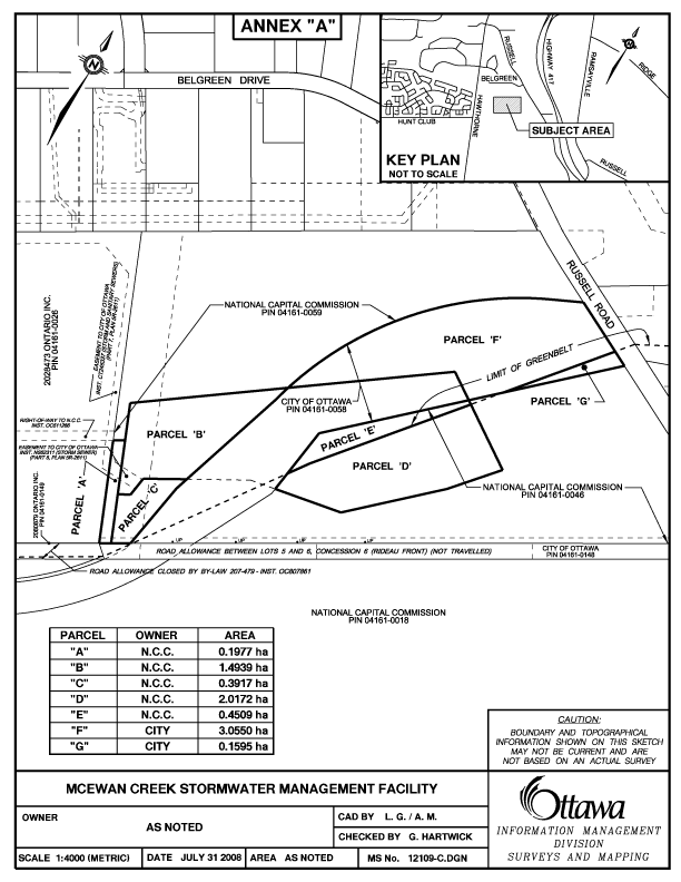
DOCUMENT ‘1’