9. SALE OF LAND – PART OF LEO LANE
Vente
de terrain – partie de l’allée leo
COMMITTEE
RECOMMENDATIONS
That
Council:
1.
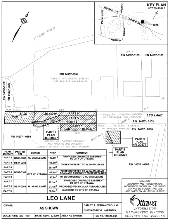
Declare a parcel of land identified as Parts 3,
4, 5 and 6 on the attached sketch identified as Document 1, containing approximately
399.69 m2 (4,302.4 square feet), described as part of Lot 1,
Registrar’s Compiled Plan No. 50, geographic Township of Cumberland, now in the
City of Ottawa, being Parts 3, 4, 5 and 6 on Plan 4R-20477 (Part of Leo Lane)
subject to the road being stopped up and closed by by-law, as surplus to the
City’s needs;
2.
Waive City Policy pertaining to the sale of
property at market value and approve the sale of land detailed in
Recommendation 1, having a value of $6,400.00, to Willard McWilliams for $1.00,
plus GST, subject to an easement over Part 5 in favour of the City of Ottawa
for drainage purposes and any other easements that may be required, in exchange
for Mr. McWilliams granting to the City easements over lands owned by him shown
as Parts 2, 7, 8 and 9 on the attached sketch identified as Document 1,
containing an area of 223.7 m2
(2,408 square feet), described as part of Lot 1, Registrar’s Compiled Plan No.
50, geographic Township of Cumberland, being Parts 2, 7, 8 and 9 Plan 4R-20477,
having a value of $4,800.00.
Recommandations DU
Comité
Que le
Conseil :
1.
Déclare excédentaire la parcelle représentée par les parties 3, 4, 5 et
6 dans le dessin ci-joint (document 1), d'une superficie d'environ
399,69 m2 (4 302,4 pi2), et décrite comme
une partie du lot 1 dans le plan dérivé no 50 du registraire,
canton géographique de Cumberland, maintenant dans la ville d'Ottawa, et
constituant les parties 3, 4, 5 et 6
dans le plan 4R-20477 (partie de la ruelle Leo), sous réserve que la rue soit
barrée et fermée par voie de règlement municipal;
2.
Renonce
à la politique municipale qui stipule qu’une proprieté doit être vendue à la valeur marchande et approuve la vente du
terrain dont il est question dans la recommandation 1, d'une valeur de
10 800 $, à Willard McWilliams pour 1 00 $, sous réserve d'une
servitude située sur la partie 5 accordée à la Ville d'Ottawa à des fins de
drainage et de toute autre servitude éventuellement nécessaire, en contrepartie
de servitudes accordées par M. McWilliams à la Ville sur les terrains lui
appartenant, représentés par les parties 2, 7, 8 et 9 dans le dessin ci-joint
(document 1), d'une superficie d’environ 223,7 m2
(2 408 pi2) et d'une valeur de 4 800 $, et
décrits comme faisant partie du lot 1 dans le plan dérivé no 50
du registraire, canton géographique de Cumberland et constituant les parties 2,
7, 8 et 9 dans le plan 4R-20477 ayant une valeur de 4 800 $.
Documentation
1. Corporate Services and Economic Development Committee report dated 19 January 2010 (ACS2010-CMR-REP-0002)
Report to/Rapport au :
Corporate Services and
Economic Development Committee
Comité des services organisationnels et du développement économique
and Council / et au Conseil
19 January 2010 / le 19 janvier 2010
Submitted by/Soumis par : Gordon MacNair, Director, Real Estate Partnerships and
Development Office / Directeur, Partenariats et Développement en immobilier
Contact Person/Personne ressource : Robin
Souchen, Manager Realty Services, Real Estate Partnerships and Development
Office/
Partenariats et Développement en immobilier
(613) 580-2424 x 21549 Robin.Souchen@Ottawa.ca
|
SUBJECT: |
|
|
|
|
|
OBJET : |
REPORT RECOMMENDATIONS
That
the Corporate Services and Economic Development Committee recommend that
Council:
1.
Declare a parcel of land identified as Parts 3,
4, 5 and 6 on the attached sketch identified as Document 1, containing
approximately 399.69 m2 (4,302.4 square feet), described as part of
Lot 1, Registrar’s Compiled Plan No. 50, geographic Township of Cumberland, now
in the City of Ottawa, being Parts 3, 4, 5 and 6 on Plan 4R-20477 (Part of Leo
Lane) subject to the road being stopped up and closed by by-law, as surplus to
the City’s needs;
2.
Waive City Policy pertaining to the sale of
property at market value and approve the sale of land detailed in
Recommendation 1, having a value of $6,400.00, to Willard McWilliams for $1.00,
plus GST, subject to an easement over Part 5 in favour of the City of Ottawa
for drainage purposes and any other easements that may be required, in exchange
for Mr. McWilliams granting to the City easements over lands owned by him shown
as Parts 2, 7, 8 and 9 on the attached sketch identified as Document 1,
containing an area of 223.7 m2
(2,408 square feet), described as part of Lot 1, Registrar’s Compiled Plan No.
50, geographic Township of Cumberland, being Parts 2, 7, 8 and 9 Plan 4R-20477,
having a value of $4,800.00.
RECOMMANDATIONS DU RAPPORT
Que le Comité des services
organisationnels et du développement économique recommande au Conseil :
1.
Déclare excédentaire la parcelle représentée par les parties 3, 4, 5 et
6 dans le dessin ci-joint (document 1), d'une superficie d'environ
399,69 m2 (4 302,4 pi2), et décrite comme
une partie du lot 1 dans le plan dérivé no 50 du registraire,
canton géographique de Cumberland, maintenant dans la ville d'Ottawa, et
constituant les parties 3, 4, 5 et 6 dans le plan 4R-20477 (partie de la ruelle
Leo), sous réserve que la rue soit barrée et fermée par voie de règlement
municipal;
2.
De renoncer à la politique municipale qui stipule qu’une proprieté doit
être vendue à la valeur marchande et approuve la vente du terrain dont il
est question dans la recommandation 1, d'une valeur de 10 800 $, à
Willard McWilliams pour 1 00 $, sous réserve d'une servitude située sur la
partie 5 accordée à la Ville d'Ottawa à des fins de drainage et de toute autre
servitude éventuellement nécessaire, en contrepartie de servitudes accordées
par M. McWilliams à la Ville sur les terrains lui appartenant, représentés
par les parties 2, 7, 8 et 9 dans le dessin ci-joint (document 1), d'une
superficie d’environ 223,7 m2 (2 408 pi2) et d'une
valeur de 4 800 $, et décrits comme faisant partie du lot 1 dans le
plan dérivé no 50 du registraire, canton géographique de
Cumberland et constituant les parties 2, 7, 8 et 9 dans le plan 4R-20477 ayant
une valeur de 4 800 $.
BACKGROUND
The property being conveyed to Mr. McWilliams is legally described as Part of Lot 1, Registrar’s Compiled Plan No. 50, geographic Township of Cumberland delineated as Parts 3, 4, 5 and 6 on Plan 4R-20477. Parts 4, 5 and 6 on Plan 4R-20477 are part of Leo Lane to be closed and contain an area of 296.4 m2 (3,190.5 square feet). Part 3, Plan 4R-20477 is vacant land and contains an area of 103.3 m2 (1,111.9 square feet).
Planning and Infrastructure Approvals Branch pursuant to the Delegation of Authority By-law 2001-12 as amended approved the closure of the portion of Leo Lane shown as Parts 4, 5 and 6 Plan 4R-20477 on Document 1 attached, subject to the following conditions:
- Notice of the proposed closing shall be
given in accordance with By-law No. 2002-522;
- A conveyance of a closed road shall be at
current market value in accordance with By-law No. 2002-38.
- The applicant/purchaser(s) will be
responsible for all costs of the road closing and sale including the
application fee (which includes the cost of advertising/giving notice),
survey/reference plan, appraisal (if any), removal of encumbrances (if
any), registration of documents, land transfer tax and GST if applicable;
- That prior to the enactment of the closing
by-law, the applicant shall provide the following material to the
satisfaction of the City Solicitor:
(i)
The
applicant/purchaser(s) shall have provided to the City Solicitor, a plan of
survey/reference plan, showing the road, or portion thereof, to be closed, the
parcels of land therein to be conveyed to all parties, any existing or required
utility easements and a registerable legal description of all such parcels of
land, to the satisfaction of the City Surveyor;
(ii)
The
applicant/purchaser(s) of all closed portions of the road being sold, shall
have provided to the City Solicitor, written confirmation that any zoning
violation which may result from the closing, will be the applicant/purchaser(s)
responsibility to remedy, and;
(iii)
A
binding Agreement of Purchase and Sale shall have been entered into by the City
and the applicant/purchaser(s) for the closed road;
- Should the conditions of Paragraph 4 above
not be fulfilled within one (1) year of the date of approval of the road
closing application, the approval of the road closing application shall be
null and void;
- The Municipal Act provides that the
closing by-law enacted by City Council does not take effect until
registered on title. If the City is
selling the closed road, the by-law will not be registered on title until
such time as the conveyance of the closed road is completed pursuant to an
Agreement of Purchase and Sale.
SPECIAL CONDITIONS
- The Applicant/Owner agrees to provide a
drainage easement over Parts 5 and 7 on Plan 4R-20477 in favor of the City
of Ottawa prior to the closure of the subject road. Dimensions of the easements shall be to
the satisfaction of the Manager, Infrastructure Approvals Division.
- The Applicant/Owner acknowledges and
agrees that the lands included in this road closing are subject to an
existing flooding easement over Parts 3, 4, 5 and 6 on Plan 4R-20477.
- The Applicant/Owner agrees to provide an
easement in favor of the City of Ottawa, 9.0 metres wide by 8.0 metres
deep, over the driveway on the lands designated as Parts 8 and 9 on Plan
4R-20477 to permit City vehicles (including emergency, snow removal and waste
disposal vehicles) to turn around at the west end of Leo Lane.
DISCUSSION
The subject City lands are located at the west end of Leo Lane between the Ottawa River inlet to the west and East Shore Lane to the east and are described as Part of Lot 1 on Plan 50 and Parts 3, 4, 5 and 6 on Plan 4R-20477.
An application was made by the Purchaser to close a portion of Leo Lane described as Parts 4, 5 and 6 on Plan 4R-20477. As this portion of Leo Lane has been approved for closure and is recommended to be sold to Mr. McWilliams, Part 3 which was conveyed to the City by the Purchaser for road purposes is no longer required for road purposes and in accordance with the Policy Statements on the disposal of Road Allowances, is being conveyed back to the previous owner for $1.00. These lands are to be incorporated into the purchaser’s abutting lands to the south.
Leo Lane was originally a private lane owned by Mr. McWilliams. The lane was conveyed and opened as a public street by the City of Cumberland in 1991 as a condition of a development agreement between Mr. McWilliams and the former City. As part of the 1991 agreement, Mr. McWilliams was required to convey lands for a road widenings along East Shore Lane and Leo Lane. The conveyance and opening of Leo Lane as a public street allowed for the creation of two lots located on either side of Leo Lane.
The eastern portion of Leo Lane between the portion being closed and East Shore Lane will continue to be a City street which will allow access to Mr. McWilliam’s property to the south as well as to the properties municipally known as 2975 and 2977 Leo Lane.
Although an objection to the road closing was received from one of the property owners on East Shore Lane claiming their right-of-way over the road to be closed will be extinguished once the road is closed and conveyed to the abutting, Legal Services have confirmed that no legal right-of-way or easement was found on title that substantiates this claim. The closing of Leo Lane was approved by City Council at its meeting held on December 9th, 2009.
The lands being sold to Mr. McWilliams described in Recommendation 1 above will be subject to an easement in favour of the City over Part 5, Plan 4R-20477 which is required for drainage purposes. As part of this transaction, Mr. McWilliams is to convey easements to the City over his lands described as Parts 2, 7, 8 and 9 on Plan 4R-20477. The easement over Parts 2 and 7 is for drainage purposes and the easement over Parts 8 and 9 is for a turnaround for City and emergency vehicles. The turnaround will eliminate the need for the western portion of the road which has been approved for closure and is being recommended for conveyance to Mr. McWilliams.
The Purchaser has not executed an Agreement of Purchase and Sale with the City. This report is being brought forward to Corporate Services and Economic Development Committee as a result of a motion moved by Councillor Jellett at the Agricultural and Rural affairs Committee on November 26, 2009. As this is a legacy matter from the former City of Cumberland, Councillor Jellett as well as staff from Legal Services and the Planning Branch have confirmed that pre-amalgamation discussions with Mr. McWilliams concluded that this transaction would be at no monetary cost to him. It is therefore recommended that City Policy be waived and that the sale and exchange of easement be for $1.00.
An independent appraisal confirms that the market value of the lands for Parts 4, 5 and 6 on Plan 4R-20477 to be sold to Mr. McWilliams, subject to an easement over Part 5, Plan 4R-20477 is $6,400.00 and that the market value of the easements being granted to the City over Mr. McWilliams property, described as Parts 2, 7, 8 and 9 on Plan 4R-20477 is $4,800.00. There is no value attributed to part 3 as this parcel is being conveyed back at no cost in compliance with the Policy Statements on the Disposal of Road Allowances.
The land exchange being recommended is considered fair and reasonable and is recommended for acceptance.
ENVIRONMENTAL IMPLICATIONS
There are no significant
environmental implications from disposal of the property. The lands being conveyed to Mr. McWilliams do
not lie within or adjacent to any features of the City’s terrestrial natural
heritage system. The lands do lie within
the regulated floodplain of the Rideau Valley Conservation Authority, which
imposes constraints on the property.
However, these constraints are recognized under Special Condition #8, in
which the Applicant/Owner acknowledges and agrees that the lands are subject to
a flooding easement.
CONSULTATION
In accordance with policies approved by City Council on 14 November 2001, the availability of the property was circulated to all client City Departments, including the Housing Services, Planning and Growth Management and City Operations, to determine if the road allowance should be retained for a City mandated program. The Land Use and Natural Systems Unit from the Environmental Management Group of Planning and Growth Management Department was consulted with respect to the Urban Natural Area Environmental Evaluation Study and Greenspace Master Plan, their comments are indicated under the Environmental Implications section of this report. Neither Housing Services nor any City Department expressed interest in retaining the property.
The utility companies were also circulated and no requirements were indicated to protect utilities.
The following Advisory Committees have been circulated:
Local Architectural Conservation Advisory Committee (LACAC)
Ottawa Forests and Greenspace Advisory Committee (OFGAC)
Environmental Advisory Committee (EAC)
Parks and Recreation Advisory Committee (PRAC)
Roads and Cycling Advisory Committee (RCAC)
Rural Issues Advisory Committee (RIAC)
Pedestrian and Transit Advisory Committee (PTAC)
No concerns were expressed with respect to the sale of the land to the abutting owner.
COMMENTS
BY WARD COUNCILLOR
I fully support staff’s recommendations.
HOUSING FIRST POLICY
The Official Plan policy directs that the City make land available for affordable housing and give priority for the sale or lease of surplus City-owned property for this purpose.
The Housing First Policy, approved by Council on 13 July 2005, establishes priority consideration to the Housing Branch in the identification of potentially surplus City-owned property to be used in achieving the City’s affordable housing program targets. The policy also requires that the Official Plan target of 25% affordable housing, be met on any City-owned property sold for residential development. Where viable residential properties are disposed of without a condition requiring an affordable housing component, 25% of the proceeds from the sale are to be credited to a housing fund to be used for the development of affordable housing elsewhere in the City.
The subject is a non-viable property and therefore does not meet the affordable housing criteria outlined in the Housing First Policy.
LEGAL/RISK MANAGEMENT IMPLICATIONS
There are no legal/risk management
impediments to implementing any of the Recommendations arising from this
Report.
FINANCIAL IMPLICATIONS
This transaction represents revenue of $1.00 to the Corporation and will be credited to the City’s Sale of Surplus Land Account.
SUPPORTING DOCUMENTATION
Document 1: Sketch showing the land being sold and the easements to be granted to the City.
DISPOSITION
Following Council’s approval, Real Estate Partnerships and Development Office and Legal Services Branches will finalize the transaction.