|
1. ZONING - 1357 BASELINE ROAD ZONAGE - 1357, CHEMIN BASELINE |
Committee recommendations as amended
(This
application is subject to Bill 51)
That Council approve an amendment to the Zoning By-law 2008-250 to
change the zoning of 1357 Baseline Road from I1A – Minor Institutional Subzone
A to AM[***] Sch [***] – h – Arterial
Mainstreet Special Exception Holding Zone as detailed in Document 2; as
amended as follows:
1. Revised
Point 18 to read:
A
maximum of 750 surface parking spaces may be provided for the entire site; the
parking spaces may be installed as the development proceeds in phases; the
parking spaces may not be located in the required or provided front or side
yards abutting a street, or more particularly in the setback of said yards which
setback may not exceed 7.0 metres.
2. Revised
Point 2 to read:
Where a single large format store is located in the east portion of
the site as part of the first phase of development, that at least two of the
six buildings shown on the concept plan (included as Document 4) shall be
constructed also as part of the first phase along Baseline and Clyde, with at
least one building located at the corner of Baseline and Clyde. And, that these buildings be completed for occupancy
within three years of the commencement of construction of the large format
store.
3. Additions
to Point 20 to read:
k. Prior to any site plan being approved,
that a full community meeting be held, involving the applicant, Copeland Park
Community, City View Community, Central Park Community, City planning staff and
the Ward Councillors representing these communities.
l. The Owner(s) not object to the formation
of a Business Improvement Area for the Merivale commercial corridor that would
include the Owner(s) lands.
m. The Owner(s) agree through the site plan
agreement to participate in future Community Design Plan Study for the
Baseline/Clyde/Merivale triangle.
4. That pursuant to the Planning
Act, subsection 34(17) no further notice be given.
Recommandations modifÉes DU Comité
(Cette demande
est assujettie au Règlement 51)
Que le Conseil approuve une modification
au Règlement de zonage 2008-250 afin de modifier le zonage du 1357, chemin
Baseline de I1A – Zone de petites institutions, sous-zone A à AM [***] annexe
[***] – h - Zone d’artère principale assortie d’une exception et à aménagement
différé, comme le montre en détail le document 2.; modifié de la façon
suivante :
1. le
point 18 révisé se lit comme suit :
Un nombre maximal de 750 places de
stationnement en surface peuvent être prévues pour l’ensemble du site;
l’aménagement des places de stationnement pourra coïncider avec les différentes
phases du projet; les places de stationnement ne pourront pas être situées dans
les cours avant ou latérales requises ou aménagées qui seront contiguës à une
rue, ou plus particulièrement dans le retrait de ces cours, ce retrait ne
pouvant pas dépasser 7.0 mètres.
2. Le
point révisé 2 se lit comme suit :
Si un magasin grande surface est
construit dans la partie est du site dans le cadre de la première phase de
l’aménagement, qu’au moins deux des six immeubles illustrés sur le plan
conceptuel (document 4) soient également construits dans le cadre de la
première phase, le long du chemin Baseline et de l’avenue Clyde, au moins un
immeuble étant situé à l’angle du chemin Baseline et de l’avenue Clyde. Et que ces immeubles soient prêts à être
occupés dans les trois ans suivant le début de la construction du magasin
grande surface.
3. Les
ajouts au point 20 se lisent comme suit :
k. Avant
qu’un plan d’emplacement soit approuvé, que soit organisée une réunion
communautaire devant regrouper le demandeur, la population des secteurs de
Copeland Park, de City View et de Central Park, des représentants des services
d’urbanisme de la Ville et les conseillers des quartiers concernés.
l. que
le ou les propriétaires ne s’opposent pas à la formation d’une zone
d’amélioration commerciale pour le corridor commercial du chemin Merivale qui
engloberait les terrains du ou des propriétaires.
m. que
le ou les propriétaires conviennent de participer, dans le cadre de l’entente
portant sur le plan d’emplacement, à la future étude du Plan de conception
communautaire du triangle Baseline/Clyde/Merivale.
4. Qu’aucun
autre avis ne doit donné conformément au paragraphe 34(17) de la Loi sur l’aménagement du territoire.
Documentation
1.
Deputy
City Manager’s report, Infrastructure Services and Community Sustainability
dated 14 September 2009 (ACS2009-ICS-PGM-0131).
2. Extract
of Draft Minutes, 22 September 2009.
Report to/Rapport au :
Planning
and Environment Committee
Comité de l'urbanisme et de l'environnement
and Council / et au Conseil
14 September 2009 / le 14 septembre 2009
Submitted by/Soumis par : Nancy Schepers, Deputy City Manager
Directrice municipale adjointe,
Infrastructure
Services and Community Sustainability
Services d’infrastructure et Viabilité des collectivités
Contact
Person/Personne-ressource : John Smit, Manager/Gestionnaire, Development
Review-Urban Services/Examen des projets d'aménagement-Services urbains,
Planning and Growth Management/Urbanisme et Gestion de la croissance
(613) 580-2424, 13866 John.Smit@ottawa.ca
|
SUBJECT: |
|
|
|
|
|
OBJET : |
REPORT RECOMMENDATION
That the recommend Council approve an
amendment to the Zoning By-law 2008-250 to change the zoning of 1357 Baseline
Road from I1A – Minor Institutional Subzone A to AM[***] Sch [***] – h – Arterial Mainstreet Special
Exception Holding Zone as detailed in Document 2.
RECOMMANDATION DU RAPPORT
Que le Comité de recommande au Conseil d’approuver une modification au Règlement de
zonage 2008-250 afin de modifier le zonage du 1357, chemin Baseline de I1A –
Zone de petites institutions, sous-zone A à AM [***] annexe [***] – h - Zone
d’artère principale assortie d’une exception et à aménagement différé, comme le
montre en détail le document 2.
BACKGROUND
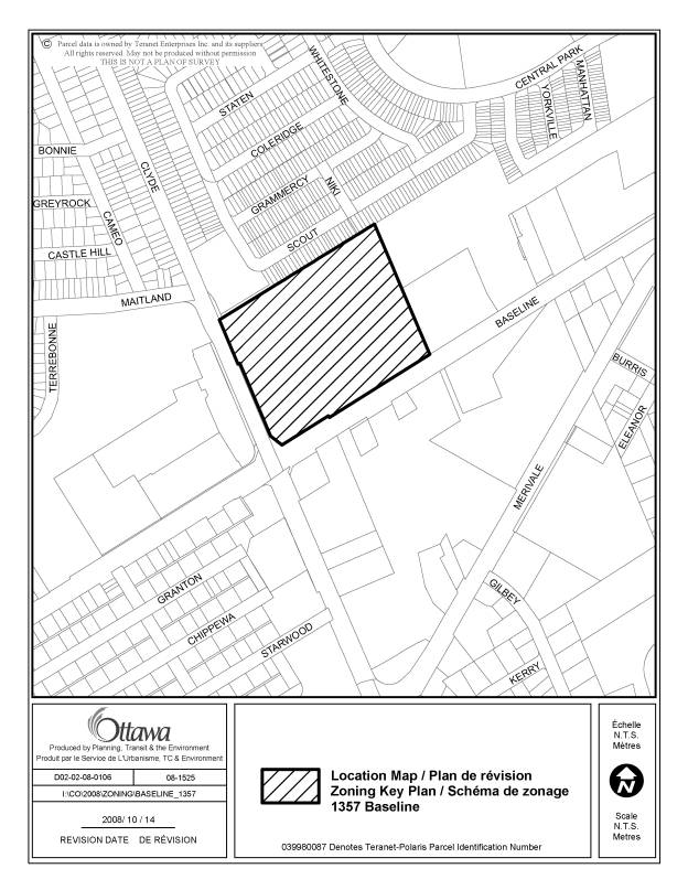
The subject property is located at the northeast intersection of Baseline Road and Clyde Avenue. Baseline Road is a four lane major arterial road running east-west. Clyde Avenue is a four-lane arterial roadway running north south that merges with Maitland Avenue to the north which continues towards the Queensway. The subject property is a corner lot with 271 metres of frontage along Baseline Road and 199 metres of frontage along Clyde Avenue. The site is approximately 6.22 hectares in size and was most recently used for institutional purposes (Laurentian High School).
The subject property is surrounded by a mix of land uses. Abutting the northern property limit are residential units within the Central Park Community. Immediately east of the site facing Baseline Road is the Scouts Canada headquarters. Along the south side of Baseline Road there is a mix of commercial and retail uses. A high-density residential development is located at the northwest intersection of Baseline Road and Clyde Avenue. There is an existing pedestrian path to the school property at the northeast corner of the site from Niki Way. A second walkway block to be constructed is located at the northwest corner of the site that will connect Scout Street to Clyde Avenue.
The subject property is designated Arterial Mainstreet in the Official Plan (OP) and is currently zoned Minor Institutional Subzone A (I1A) reflecting the previous use of the property as a high school. This zone permits predominately institutional type uses including schools, a community centre, retirement home, place of assembly and sports arena. Any development for a use not permitted under the current zoning, but that would be consistent with the OP designation applicable to the site, requires an amendment to the Zoning By-law.
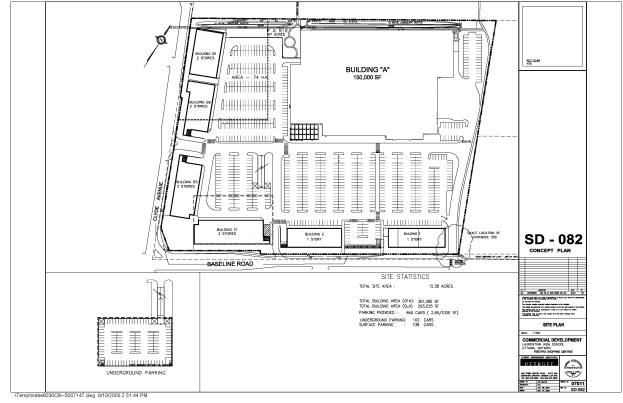
The applicant is proposing to develop the site as a predominately retail center with some upper floor office space for those buildings proposed to front onto Baseline Road and Clyde Avenue with future potential to accommodate residential and/or more intense office development. To permit this development, the applicant has submitted an application to have the property rezoned to an Arterial Mainstreet (AM) zone. The applicant’s development concept for the retail center is shown on Document 4. To date, a formal application for Site Plan Control has not been submitted.
The proposed development is focused on providing a stand-alone single large format retail store located in the northeast quadrant of the site adjacent to the Central Park residential community that abuts the site to the north. The remainder of the site would be framed with buildings ranging in height from one to three storeys along the frontage of Baseline Road and Clyde Avenue with upper floors accommodating approximately 7620 square metres of office space. The total retail square footage proposed for the site is approximately 20400 square metres with the total density proposed reflecting a 0.5 FSI. Approximately a 0.8-hectare portion of the property would be reserved for a period of time to pursue residential and/or additional office development on the site. Parking for the site would be accommodated internally with the majority of parking provided at grade and a portion proposed to be provided either underground or within a parking structure.
The applicant proposes that the first phase of construction would be the proposed approximately 9200 square metre stand-alone single-use retail store in the northeast quadrant of the site. The intent would be to construct and have completed some or all the buildings framing Baseline Road and Clyde Avenue within five years. Due to the need to ensure that some significant site plan matters will be resolved prior to this development occurring, the applicant has agreed to proceed with the zoning change with the introduction of a holding provision which would not be lifted until such time that site plan approval is given for development of the site. The site plan would address the details of the site development related to location of buildings, access, landscaping, servicing and roadway modifications that may be required and ensuring that more intense mixed use development will be able to be accommodated over time.
DISCUSSION
The subject site is located strategically within a fully developed urban area where there exists considerable potential for renewal and redevelopment in a way that significantly advances the policy objectives of the Official Plan for accommodating higher density mixed use development that can contribute to creating complete communities and that can support increased use of sustainable transportation. However, for the subject site, the level of development that can currently be accommodated is limited, as on other sites throughout the city, by factors such as the surrounding transportation network and the availability of services. The development proposed by the applicant is seeking to capitalize on the present development potential of the site, but will also need to be designed to allow for more intense development to be achieved over time so as to enable the site to be developed in a way that fully advances the policies of the Official Plan.
In reviewing the rezoning application, the key considerations relate to how the development as proposed by the applicant, does or does not respond to and/or address applicable strategic directions and policies of the Official Plan and the directions set out in the Council approved Arterial Mainstreet and Large Format Retail Urban Design Guidelines. Similarly the staff recommendations have been developed with a view to ensuring that development of the site will be able to achieve its short and long term potential for intensified mix use development beyond a retail center typical of what would be developed outside the greenbelt.
This type of development program having an effective FSI of 0.5 from staff’s perspective, while appropriate today, given the site’s constraints, represents underdevelopment when considering the intent of the Official Plan’s policies and does not achieve the site’s potential. To achieve the site’s potential over time requires that the placement and construction of buildings be designed to consider further development and intensification. Towards this end, the staff recommendation will require the owner to demonstrate how their initial proposal will allow, in the future more intense mixed-use development. In staff’s view those issues must be addressed and accommodated as part of any development program. The staff recommendation therefore is directed to ensuring that development of the site will occur in a way that can accommodate the applicant’s needs while also ensuring that the City’s urban design objectives for development along arterial mainstreets will be meet and that more intense mixed use development can be achieved over time as constraints are addressed.
Staff’s assessment of the applicant’s development proposal relative to Official Plan directions and how the staff recommendations will support achieving the City’s objectives is discussed in the following sections. This discussion highlights the site’s potential as established by the policy framework of the Official Plan, the current constraints that limit the potential today to achieve the site’s potential and a review of how the applicant’s proposal responds to the Official Plan’s planning and design objectives and how it will or will not achieve the site’s potential. Details of the staff recommendations are explained ensuring that the initial development program of the site will achieve the site’s potential to meet the City’s design and planning objectives for development along arterial mainstreets.
Official Plan Policy Framework - Site Potential
The site’s potential is directly related to the policy framework set out in the Official Plan which encourages and requires intensification within the urban area through mixed use development that will support the establishment of pedestrian oriented urban places at strategic locations. Arterial Mainstreets are identified as one of the areas within the urban structure where these objectives are to be achieved. The policy framework defining the site’s potential is discussed in this section.
Strategic Directions
Section 2 of the Official Plan sets broad strategic directions to meet the challenge of managing growth, providing infrastructure, maintaining environmental integrity and creating liveable communities within Ottawa. To meet these challenges, there is clear direction to provide for a mix of land uses and compact forms of development at strategic locations that will enable the City to support a high-quality transit system and make better use of existing infrastructure and roads. Consistent with this broad direction, Section 2.2.3 specifically directs growth within the Urban Area to locations with significant development potential, and especially to areas designated Central Area, Mixed-Use Centers, Employment Areas, Enterprise Areas, Developing Communities and Mainstreets. The objective for these areas is to have them develop as mixed-use areas, which includes housing, employment, shopping and recreation and at a density that can achieve a level of intensification that achieves the City’s intensification objectives and fits and works relative to the site’s urban context. A mix of land uses will allow for live-work relationships and reduce the need to travel to other parts of the city with more intensified development providing for maximizing use of existing infrastructure in particular increased use of sustainable transportation and to contribute to creating more complete sustainable communities that respects and builds on existing patterns of development. To ensure fit and appropriate integration of development within the existing urban fabric, specific direction is set out in Section 2.5.1 for the review of development proposals which includes accessing the scale of development and its compatibility. The strategic directions set out in Section 2 are the foundations for the policy directions and land use designations set out in the Official Plan.
The subject property is designated Arterial Mainstreet in the Official Plan. The Mainstreet designation identifies streets that offer some of the most significant opportunities for intensification through compact development and a lively mix of uses. On Arterial Mainstreets, development is to occur in a way that facilitates the gradual transition to more intensive forms of development which could mean, over time, high density employment and residential uses being introduced where appropriate. To facilitate this evolution, the Zoning By-law may define the portion of the street frontage of an Arterial Mainstreet to be occupied by buildings located at or setback from the sidewalk. The Urban Design Guidelines for Arterial Mainstreets give further guidance towards implementing the policies of the Official Plan.
In addition to encouraging more intense mixed use development, another key direction for Arterial Mainstreets is for development to have a strong street orientation so that Arterial Mainstreets can evolve from hostile vehicular corridors to more comfortable, animated pedestrian corridors that can contribute to these streets becoming seams between communities on either side rather then being characterized as edges to communities and barriers for true integration of communities. This is a key element that the applicant’s initial development proposal must fully embrace to ensure that the initial development program will allow for more intense development to be achieved and to ensure that the development does not reflect an automobile oriented retail shopping center.
Recognizing the ability and need for arterial mainstreets to accommodate higher profile development to effect the evolution in character called for by the Official Plan, heights along arterial mainstreets under the Official Plan can be up to eight stories with higher heights permitted under any one of a number of conditions. The subject site meets several of these and therefore is appropriate for buildings higher then eight stories.
Compatibility Considerations
Section 2.5.1 sets out broad design objectives as qualitative statements on how the City will influence the evolution of the built environment. These objectives, which are applicable to all land use designations are focused on enhancing the sense of community and maintaining places with their own distinct identity, providing quality public and private spaces through development, creating places that are safe, accessible and are easy to get to and move through, ensuring that new development respects the character of existing areas, creating places that can adapt easily and evolve over time and that are characterized by variety and choice and promoting environmental sustainability in development. Design principles are set out to further describe how each of the design objectives may be achieved.
Site Potential
In the context of the policy direction of the Official Plan, the site, given its strategic location and size exhibits tremendous potential.
As the property formerly accommodated a secondary school with a low level of development that was part of the community with high community focus, there is a significant opportunity for this integrated relationship and community focus to continue, albeit from an institutional and recreational facility to a mix of new retail, commercial, employment and residential uses, all within a more intense form of development that is respectful of the scale of abutting developments while also moving forward the policies for Arterial Mainstreets.
The potential to remain an integrated element and community focus is through the provision of appropriate forms of open space, landscaping and pedestrian walkways, along with complimentary building form and a mix of uses and designs all which are contributing towards the creation of a true sense of place for residents and visitors to enjoy. The ideal location of the site at a major intersection creates a natural focus point for the area, and location to accommodate uses that draw people towards this area. Safe, attractive and well designed pedestrian scale elements will establish the site as a people and pedestrian area. This in turn supports an increase in the activity on the site creating an animated environment for prolonged periods versus the former use.
With new and continuing residential development to the north in the Central Park neighbourhood, established neighbourhoods to the west and south and office and service uses along Baseline Road and Merivale Avenue, the site has great potential to establish itself as an area with a combination of these uses to establish a new mixed-use form that extends the fabric of the community onto the site whereas traditionally uses have been typically found clustered, such as retail strip plaza’s or individually on separate parcels. Such a development has the potential to serve as a template for similar developments throughout the city along Arterial Mainstreets.
Lastly, with such a desirable location serviced by public transit and close to the Queensway, the site has the ability to provide for the employment, service, retail and residential needs of the surrounding area while potentially reducing automobile dependency and encouraging alternative forms of transportation. The application of the Urban Design Guidelines for Development along Arterial Mainstreets and Large Format Retail Urban Design Guidelines will be critical in the evaluation of a forthcoming application for Site Plan Control.
Current Constraints to Achieving Potential
Traffic
A key issue that staff, the community and the applicant have been dealing with related to the review of the application is traffic. The Baseline Road and Clyde Avenue and Baseline Road and Merivale Road intersections are known as two of the more congested intersections in the city where intersection failure during the peak periods is common. This is a result of these three streets being major arterials carrying very high volumes of commuter traffic across town from the south to the downtown and in east to west directions. Currently both intersections operate at Level of Service (LoS) “E” in the PM peak and at LoS “D” in the AM peak. The congestion at these intersections has also contributed to concerns related to cut through traffic in particular for the Copeland Park community.
As part of the submission requirements for the rezoning, the applicant was required to prepare a traffic study to assess the additional traffic that could be expected as a result of the development proposed and the ability of the area road network and intersections to accommodate the increased traffic. The study concluded that some intersection modifications could be undertaken that would improve the operations of the Baseline Road and Clyde Avenue and Baseline Road and Merivale Road intersections but that the improvements realized would immediately be lost once the development is completed resulting in maintaining a status quo for the operation of these intersections. This is one of the key constraints to achieving more intense mixed-use development at this time resulting in the level of development that is able to be achieved now being limited to what is being proposed by the applicant.
From staff’s perspective, central to the traffic discussion are conflicting policy directions. On one side, the strategic directions set out in the Official Plan are advocating for more intense development, improved transit and establishing a land use pattern that supports increased transit use and promotes greater mobility choice for people to use alternative travel modes. On the other side the Transportation Master Plan (TMP) sets out a threshold for LoS for intersections to operate at LoS “D” or better. In the context of the subject application, achieving the strategic directions of the Official Plan is not possible if the LoS threshold of the TMP is to be respected. Resolution of this conflict however requires a broader policy debate which is something that is beyond the scope of matters that can be addressed in the context of dealing with a site specific rezoning.
Also, while Baseline Road is designated as a transit priority corridor in the Official Plan and TMP, work remains to be done to achieve the transit priority objectives for Baseline Road. Resolution of the current policy conflict and/or implementation of works to establish Baseline Road as a transit priority corridor are initiatives that can provide for realizing more intense mixed use development for the site in the future. Staff is of the view that the zoning established should be designed to allow for this and this is being proposed by setting out provisions that will achieve this with holding provisions that will limit development until the current transportation limitations based on current policies and transportation infrastructure are addressed. This, in staff’s view, represents a more sustainable approach to establishing an appropriate zoning for the site.
Servicing Issues
The policies of Subsection 4.4 Water and Wastewater Servicing of the Official Plan require adequate services for new development. The applicant has demonstrated that the property is adequately served by water and sewer facilities and staff have confirmed, on a high level basis, that sufficient capacities are available to accommodate more intense development. However, detailed studies would be required to support the high level determinations made by staff.
The key constraint from a servicing perspective to achieving more intense development as identified through the processing of the rezoning application relates to hydro service. In this regard, Hydro Ottawa has advised the applicant and staff that the proposed level of development would have adequate servicing, however infrastructure limitations would impact the potential of the site to intensify to a greater level without a very significant investment to provide for costly service extensions. Given the transportation constraints that limit realizing the site’s full potential today, it is difficult to justify moving forward with the required hydro service extensions at this time.
Assessment of
Development Proposal
Staff have reviewed the development proposed by the applicant that is reflected in Document 4 in the context of the Official Plan and the Council approved Arterial Mainstreet and Large Format Retail Design Guidelines. Based on this review, staff have concluded that the applicant’s development program has ingredients that address the planning and design objectives and principles set out in the Official Plan and in the above-noted guidelines. In this regard, the proposed development redefines the use of the site from institutional to a use that fits better into the uses contemplated under the Arterial Mainstreet designation and is responding, given the site’s current constraints that limit development intensity, to certain design objectives and principles set out in Section 2.5.1. and in the arterial mainstreet and large format retail design guidelines. Most notably, the development is proposing some multiple storey street edge buildings along Baseline Road and Clyde Avenue to allow for the transformation of these streets from hostile vehicle corridors to more pedestrian-friendly streets. However, as the development proposal currently reflects a low density development program (0.5 FSI) and is characterized predominately as a retail center, there remains considerable potential for the site to be further developed to accommodate more intense mixed use development subject to the current constraints being addressed. This would provide for the development of the site to become a truly urban development that creates a strong community focus.
The applicant’s development proposal in staff’s view, is seen as an initial development program that has been developed to be consistent with certain key elements of the form of development and mix of uses called for by the Official Plan for Arterial Mainstreets. The site development proposes a large format anchor tenant and perimeter buildings around a central surface parking area. As well, a portion of the site would be reserved for a period of time to bring forward and further evaluate opportunities for residential and/or more intense office development on the site to try to advance a more mixed use development program as part of the initial development program. Staff is of the view that a residential element could provide for integrating the site into the residential fabric of the adjacent communities with more intense office development contributing to a more sustainable development program.
The basic elements to ensure that the site’s potential can be achieved are reflected in the initial development program. However, to ensure that the current proposal will allow for the achievement of the site’s ultimate potential and ability to fully advance the planning and design objectives of the Official Plan for arterial mainstreets, matters related to having uses oriented to the street, and certain other site plan matters will need to be more fully developed through the Site Plan Control Process.
With respect to ensuring street oriented retail, the applicant, as part of the rezoning has submitted artist’s renderings and has indicated that their objective for the development is to provide for a street orientation for the initial development with display windows and doors provided from Baseline Road and Clyde Avenue. Staff sees this as being absolutely critical for the development of the site to ensure development will not be an inward oriented retail shopping center where uses are oriented to the internal parking area rather then being oriented to the street with well defined pedestrian connections from the internal parking to the street edge lacking. Staff also considers it important that sufficient street edge setbacks be provided that will allow unique street environments to be established to cater to pedestrian comfort, safety and interest. Because of the importance of ensuring that the development will be street oriented, staff are recommending several provisions under the zoning as matters to be addressed through the site plan control process.
Not having the development street oriented, in staff’s view, can also frustrate achieving more intense development where surface parking is currently proposed adding further to the significance of certain details of staff’s recommendation. With a street orientation as called for by the Official Plan, there exists potential to replace the surface parking with structured parking and higher profile residential and/or office development above. In this regard, notwithstanding the allowed heights under the Official Plan for development along arterial mainstreets and the applicant’s proposal for a low profile development with three-storey and one storey buildings along Baseline Road and Clyde Avenue, the Official Plan as noted allows for eight storey development along arterial mainstreets and supports higher buildings where any one of several conditions are meet. Under this policy, staff feel that buildings to a height of 15 storeys can be accommodated internally on the site with height limits stepping down to the north to ensure a compatible relationship between heights on the site and adjacent areas to the north while limiting heights adjacent to the street edge to eight stories.
Higher profile development internal to the site with an eight storey street edge profile will allow for intensifying development and would better define the street at a building height to street width ratio that can further advance the Official Plan and Arterial Mainstreet design guideline objectives for having the street transformed to a more pedestrian focused urban street. However, the site needs to be organized such that this further intensification can be easily achieved. The applicant’s development concept as reflected in Document 4 in staff’s view, with the required street orientation for uses for the perimeter buildings, will allow for achieving this more intense development.
With respect to the applicant’s current low profile proposal, and especially the one storey street edge buildings proposed, while staff would prefer that all street edge buildings have a minimum height of two stories, staff are prepared to accept the proposed one storey elements provided the buildings have an effective height that would be associated with a two storey building. This will ensure that the urban design objectives associated with having multiple storey buildings so as to contain the street and to support the evolution of the street from one that has been designed as a traffic artery to a more urban street that is enclosed by buildings of appropriate height to make the street a more humane environment for pedestrians and diminish its automobile oriented design will be achieved. Staff are satisfied that the current development program will provide for the basic framework to achieve this.
Other items that require resolution to ensure the site’s ultimate potential can be realized relate to various site plan matters. These include location of loading areas, ensuring that the initial development provides a framework for well defined internal pedestrian systems, integration of the development with adjacent lands and in particular the residential community to the north. To address these matters, the applicant will need to ensure that the initial development program is designed such that it provides the development structure needed to address these matters more fully when increased development is able to be achieved.
Achieving the Site’s Potential – Details of Staff Recommendation
The staff recommendation proposes an amendment to By-law 2008-250 from the Minor Institutional – I1A subzone applying to the property to an AM[***] Sch [***] – h, Arterial Mainstreet Special Exception zone with a holding provision. The proposed by-law would introduce specific performance standards and holding provision requirements to direct the development of the site consistent with the strategic directions and the applicable Arterial Mainstreet policies of the Official Plan. It is the intent of the implementing by-law to require a minimum form of development be introduced on the subject lands as reflected by the applicant’s proposal that can be supported under current conditions and requiring constraints to be resolved prior to more intense development occurring. As the subject site is located in a strategic urban location along a major Arterial Mainstreet, there is an ideal opportunity and staff feel a necessity in the context of the Strategic Directions of the Official Plan that development of the site advance the policies of the Official Plan related to development along Arterial Mainstreets in both the short term and longer term. The initial development therefore will need to establish a framework for more intense development over time. The applicant’s current proposal in staff’s view will allow for this framework to be established. Document 2 sets out the details of the recommended zoning.
The key features of the recommended zoning relate to the holding provisions being recommended and to the performance standards to ensure street oriented development, allowing for higher profile development, and setting out minimum and maximum street edge setbacks.
The holding zone provisions set out requirements both for the initial development proposed by the applicant and for achieving more intense development over time as constraints are resolved. For the initial development, a key element of what will be required, in addition to obtaining Site Plan approval, is a demonstration on how the applicant’s initial development will allow for more intense development to be achieved over time. A number of specific site plan matters that will need to be addressed as part of the initial development program are also detailed for council approval to establish a frame of reference for developing the site plan that is to be approved to accommodate the applicant’s initial development program
The key performance standards being recommended are directed to ensuring that the site will develop in a way that is consistent with the directions set out by the Official Plan for development along arterial mainstreets to have a strong street orientation and to allow the intensity of development considered suitable for the site under the policy framework of the OP to be realized over time.
To ensure that the street side of the street retail will be the front door and the area where access to the retail uses will be provided, the staff recommendation requires that storefronts along the frontage of Baseline Road and Clyde Avenue be oriented to these streets and for this frontage to act as the primary entrance for customers. As well, the recommended zoning will direct all loading, servicing and emergency exits to be located internal to the site. Staff is also requiring a minimum setback from Baseline Road and Clyde Avenue to allow for the establishment of a comfortable pedestrian environment along the street that is distinguished and sheltered from the high volume traffic activity on the adjacent roads. This recommendation will require the applicant to think differently on how to develop the site so that it will not be reflective of developments where the street side of the retail reflects a secondary entrance and not a primary entrance. The applicant, while noting that this will be challenging, has agreed to ensure that a street orientation for retail is achieved to ensure that the site’s potential over time can be realized.
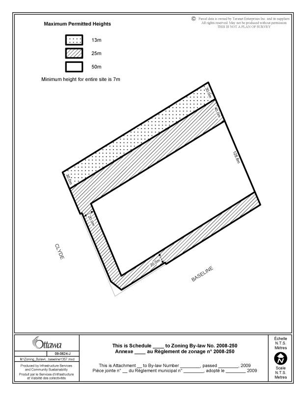
With respect to future development, given the opportunity for the site to accommodate higher profile development under the policies of the Official Plan, staff in addition to recommending a minimum height for all building along the frontage of Baseline Road and Clyde Avenue of seven meters, is also recommending an increase in height for portions of the property as shown on Document 3. Staff feel these heights are compatible with the scale of existing development in the immediate area, and will allow more intense development to be appropriately achieved to support the transformation of the site and this section of Baseline Road to become a true urban place.
A number of other performance standards are also set out in Document 2 that both staff and the applicant are in agreement on.
Requirements for the Lifting of the Holding Provision
Building further upon the performance standards set out in the recommended zoning, as part of the application for Site Plan Control approval which will be required to lift the holding provision specific elements that address issues such as pedestrian connections and linkages, a continuous street frontage, the creation of a focal point and parking must be addressed as detailed in Document 2 prior to Site Plan approval being given. A key element of these is the applicant demonstrating how the initial site plan to accommodate the initial development program will accommodate more intense development over time. This will set the framework for the final site design for the initial development program. The specific matters detailed in Document 2 that are to be addressed prior to the holding provisions being lifted to allow for the applicant’s development as proposed today and to allow for future more intense development are highlighted below.
- Site plan approval being obtained for development of the site that addresses the development requirements set out in Document 2.
- Where the site is developed in phases with the first phase being the single large format store, the first phase of development is to include at least two street edge buildings that are to be constructed within five years with the brownfields funding that the applicant has applied for being withheld until these street edge buildings are completed.
- As part of the first Site Plan Agreement, holding for a period of five years a 0.74‑hectares area of the site the northwest section of the property to pursue as part of the first phase of development either residential development or an office development in addition to the retail being proposed.
- Providing for improvements to the Clyde/Baseline and Merivale/Baseline intersections to be undertaken as part of the works related to the first site plan with appropriate agreements to ensure this being in place.
- The City being satisfied with and having given approval as part of the site plan for the first site plan of all proposed site accesses.
- For development of the site that is above a 0.5 FSI (the effective FSI for the applicant’s current proposal), a revised site plan for any additional more intense development would need to be approved and confirmation would be required related to adequacy of services and that transportation matters have been or able to be resolved.
With the zoning details recommended, the requirements to be satisfied prior to the lifting the holding including the matters to be addressed as part of the Site Plan. The site will be developed such that the applicant’s proposal will be accommodated in a way that will also allow for further more intense development to realize the sites potential to advance the Official Plan directions for development along Arterial Mainstreets.
ENVIRONMENTAL IMPLICATIONS
A Phase II Environmental Site Assessment and a Soil Contamination Delineation Report have been submitted to staff for review and has confirmed that the site is contaminated and is therefore eligible for brownfields funding. The proponents have submitted a request for this funding to assist with remediation costs. A report dealing with this request is being brought forward. A Record of Site Condition (RSC) will be required as per the funding program.
CONSULTATION
Notice of this application was carried out in accordance with the City's Public Notification and Consultation Policy. Two public meetings were held on November 4, and November 6, 2008. As a result of the comments received from the public meetings and circulation dominant issues concerning the project were brought forward from individual members of the public, community organizations and abutting landowners. A summary of the comments received and a response is included in Document 5.
LEGAL/RISK MANAGEMENT IMPLICATIONS
If the staff recommendation is approved and the zoning is appealed to the Board, the resulting hearing would be estimated to be of five days duration and could be accommodated within staff resources. Should the zoning be refused and the refusal appealed to the Board, it is estimated that a two week hearing would result. Outside witnesses would need to be retained by the City and the estimated cost would be in the range of $200,000 to $300,000.
FINANCIAL IMPLICATIONS
APPLICATION PROCESS TIMELINE STATUS
The application was not processed by the "On Time Decision Date" established for the processing of Zoning By-law amendments due to considerable amount of public interest generated by this proposal that resulted in several public meetings being required. As well, there was a need for extensive discussions with staff to deal with technical and planning considerations that were central to determining a staff recommendation.
SUPPORTING DOCUMENTATION (Immediately follows the report)
Document 1 Location Map
Document 2 Details of Recommended Zoning
Document 3 Zoning Schedule
Document 4 Development
Concept
Document 5 Consultation
Details
DISPOSITION
City Clerk and Solicitor Department, Legislative Services to notify the owner, applicant, OttawaScene.com, 174 Colonnade Road, Unit #33, Ottawa, ON K2E 7J5, Ghislain Lamarche, Program Manager, Assessment, Financial Services Branch (Mail Code: 26-76) of City Council’s decision.
Infrastructure Services and Community Sustainability Department to prepare the implementing by-law, forward to Legal Services and undertake the statutory notification.
Legal Services to forward the implementing by-law to City Council.
LOCATION
MAP DOCUMENT 1
DETAILS OF RECOMMENDED ZONING TO BE MODIFIED DOCUMENT 2
That the property known municipally as 1357 Baseline Road will be rezoned from I1A to an AM exception zone with a holding provision.
The exception will set out provisions similar in effect to the following:
Site
Development
1. Only one large format retail use building is permitted within the zone.
2. For the purpose of the zone, a large format retail use building has a minimum 30,000 square foot GFA and a maximum of 150,000 square foot GFA.
3. Notwithstanding any future severances or other land divisions, the entire lot will be considered one lot for by-law purposes
Location of Uses
4. Residential use buildings are only permitted along the northern portion of the site adjacent to the Central Park community.
5. Except for any building located within the area to be reserved for residential or office development as set out in clause 20(d) the ground floor of buildings as referenced by clause 13 shall be restricted to the main commercial uses of this AM zone with lobby areas and access areas for upper floor uses being limited to an aggregate maximum 15% of the GFA of the ground floor of each building.
6. For a building or buildings located within the area to be reserved for future residential and/or office development as set out in clause 20(d), the requirements set out in clause 5 for ground floor uses and the limitation of 15% of GFA of ground floor area for second floor access and lobbies will only apply for that portion of a building that is not a residential use building located within 20 metres of the Clyde Avenue lot line
7. The following non-residential are not permitted on the ground floor of any building as referenced by clause 13.
a. broadcasting studio,
b. catering establishment,
c. diplomatic mission,
d. place of assembly,
e. place of worship,
f. production studio,
g. research and development centre,
h. school,
i. technology industry, and
j. training centre.
In the case of the following uses:
a. amusement center
b. instructional facility
c. office
d. medical facility
An individual use or the aggregate of these uses located on the ground floor of a building as referenced by clause 13 are limited to an area of 500 sq.m. per building.
8. An above grade parking garage is only permitted where it is screened from view from the street and adjacent residential zones by landscaping and architectural features.
9. The following uses are not permitted in this zone:
a. automobile dealership,
b. automobile rental establishment,
c. automobile service station
d. car wash
e. drive-through facility
Building Characteristics
10. Any commercial use located on the ground floor within a building setback as referenced by clause 13 from a lot line abutting Baseline Road and/or Clyde Avenue must:
a. have its customer main entrance and primary see through windows facing that street; and,
b. only have a secondary customer entrance facing the interior of the site.
c. have all loading areas located internal to the site with access provided from internal roads and/or service driveways
11. Tenancies occupying less than 140m2 GFLA on the ground floor, may be oriented to and have their primary entrance provided from the interior of the site only where such tenancies do not occupy more then an aggregate total of 25% of the ground floor area of the building. Tenancies occupying less than 140m2 GFLA that have their orientation to the interior of the site may not abut one another.
12. The minimum and maximum building heights are set out on a schedule as shown on Document 3.
Performance Standards
13. Any building located within 20 metres of Baseline Road or Clyde Avenue must be setback to provide a minimum distance of 6.0 metres between the curb of any widened right-of-way secured through a site plan approval along Baseline Rod and Clyde Avenue and may not be setback more than a maximum of 7.0 metres from the street edge lot line.
14. Minimum required interior side yard setback:
a) where abutting a residential zone: 9 metres all of which must be landscaped with soft landscaping,
b) all other cases: 7.5 metres.
15. Minimum required rear yard setback : 7.5 metres
Parking and Loading
16. Minimum required number of loading spaces for all uses up to a 0.5 FSI on the lot: 2
17. Any loading areas shall be located or screened so as not to be visible from the abutting streets, residential areas and from a pedestrian linkage from the Central Park Community to Baseline Road.
18. A maximum of 750 surface parking spaces
may be provided for the entire site and may not be located in a required or
provided front yard or side yard abutting a street.
Removal of Holding
19. None of the permitted uses are allowed until the holding symbol is removed in whole or part.
20. The following conditions shall be met before the holding zone is removed in whole or in part:
a) An application for Site Plan Control has been approved and an agreement has been registered.
b) In the case of development greater then 0.5 FSI, the holding status shall apply until:
i) A revised Site Plan for the development has been approved and the required revised agreement entered into.
ii) Confirmation that adequate municipal services are available to meet the needs of the development.
iii) That transportation needs based on applicable policies and standards in place at the time of any such development can be met to the satisfaction of the City.
c) In the first Site Plan Agreement, the Owner will reserve 0.74ha of land in the North West section of the property for either a residential development or an office development. This reservation shall expire five years after the date of the first site plan agreement on this property.
d) Where a single large format retail store is to be located in the northeast portion of the site as part of the first phase that are required to support the proposed development, at least two buildings shall be constructed either at the corner of Baseline Road and Clyde Avenue or on the Baseline Road frontage also as part of the first phase for occupancy within five years of commencement of construction of the large format store.
e) The City will retain the brownfields grant funding until the street edge buildings required by (d) have been completed.
f) The Owner(s) agreeing through the Site plan Agreement to work with the City to prepare an implementation strategy to the satisfaction of the City for the recommendations of the O-D Survey Study that has been completed by the Owner(s) and that has identified community traffic issues including but not limited to, cut through concerns in certain adjacent neighbourhoods and possible mitigative measures.
g) The Owner preparing the required roadway modification plans and assuming responsibilities and costs as may be determined with required front ending and construction agreements entered into for the implementation of roadway modifications that are required to support the proposed development as identified through the approved Traffic Study prepared for the development as part of the rezoning and that includes but is not necessarily limited to intersection modifications at Clyde Avenue /Baseline Road and Baseline Road / Merivale Road to the satisfaction of the City.
h) The City is satisfied with and has approved all accesses to and from the site from Baseline Road and Clyde Avenue.
i) Any site plan that is approved must, either on the plan or within the required agreement, at a minimum include and/or address the design and development requirements set out below to the satisfaction of the General Manager, Planning and Growth Management.
j) Only landscaping shall be permitted on
the areas outlined in clause (d) until such time that site plan control
approval is granted for said buildings.
Design and Development
Requirements
The design and development of the redevelopment of 1357 Baseline Road shall be subject to the following in addition to all other applicable City of Ottawa Design Guidelines as approved by City Council.
1. Provide for clear demonstration how future more intense and mixed use development over an effective FSI of 0.5 will be accommodated and integrated into the initial development program for the site if the intent is to develop the site initially with an effective FSI at or below 0.5.
2. The provision of a landscaped pedestrian connection from the Central Park Community to Baseline Road along the east side of the zone within a fully landscaped corridor that provides a unique pedestrian experience through the landscape design and provides appropriate separation and buffering from vehicular routes.
3. Development of a focal element on the corner of Baseline Road and Clyde Avenue. This may be an open space focus that is animated and provides for a connection to the interior of the site or may be a higher profile building within the height limits set out under the zoning.
4. Development of an internal street system serving as access drives and service corridors that are distinguished and separate from the key pedestrian routes and links to be provided on site.
5. Clearly defined pedestrian corridors with animation that direct users to street edges.
6. Provision of extensive berming and landscaping using well developed trees with a minimum calliper of 10cm to screen the back wall of the single large format retail store that is permitted on the rear portion of the site.
7. Building elevation plans for all proposed buildings in each stage of development reflecting a high architectural standard that provides interest and animation of facades with extensive glazing in the form of see through display windows, articulation, landscaping features, street furniture and primary entrance doors facing street edge sidewalks and upper floor windows, to avoid expansive stretches of blank wall conditions along street edge sidewalks and along key internal pedestrian routes. The elevation plans will be approved as part of the Site Plan for each phase of development.
8. Buildings
along Baseline Road and Clyde Avenue must provide access for customers and
display windows for each business occupying space that extends to the Baseline
Road and/or Clyde Avenue fronting building wall in accordance with the
requirements set out in the zoning provisions. The Owner shall, through the
site plan agreement, enforce the requirement to maintain the street accesses
and display windows such that a pedestrian oriented street environment is
maintained. The Owner must provide and enforce provisions to this effect in the
management of the property and/or in purchase or lease agreements with the
occupants, failing which the Owner acknowledges and shall also include in all
lease agreements provisions that the City will enforce the requirements of the
Site Plan Control Agreement.
ZONING SCHEDULE DOCUMENT 3
DEVELOPMENT CONCEPT DOCUMENT 4
CONSULTATION DETAILS DOCUMENT 5
NOTIFICATION AND CONSULTATION PROCESS
Notification and public consultation was undertaken in accordance with the Public Notification and Public Consultation Policy approved by City Council for Zoning By-law amendments. Two public meetings were also held in the community on November 4 and November 6, 2008. City staff, the applicant, their agent and the Ward Councillor, Councillor Maria McRae were in attendance at all meetings. Councillor Chiarelli was in attendance at the meeting on November 6.
SUMMARY OF PUBLIC INPUT
Based on numerous comments received from two public meetings on November 4 and November 6, 2008, e-mails and letters, the main concerns expressed over the undertaking have been categorized into the issues below. As well, there were general comments from the public which stated there was a great opportunity to redevelop the site if done so in a manner that was respectful of the area and was designed well. The redevelopment of a major intersection with a pleasing urban design was generally supported subject to consideration of the issues outlined below.
Concerns with
respect to the application for rezoning and lifting of the holding provision.
1. Concerns were raised with respect to the process of approving an application for a change in zoning without an accompanying application for Site Plan Control.
Response:
An application for Site Plan Control is not required to be submitted along with an application for a change in zoning. To assist the planning justification the applicant has prepared and submitted a concept plan for the development. It is not uncommon to see a concept plan submitted with an application for a change in zoning in order to help justify and demonstrate the performance standards being proposed for the undertaking such as building locations, parking etc.
2. Concerns were raised with respect to the process for the removal of a Holding Provision and which Councillor(s) should have the ability to remove delegated authority.
Response:
The process for the removal of a holding provision is an application for a change in zoning to remove the “h” symbol from a by-law under Section 36 of the Planning Act. In Ottawa the approval of such an application is delegated to staff, however the Ward Councillor where the application is located may withdraw delegated authority. Should the Ward Councillor withdraw delegated authority, a report would then be prepared by staff and presented to Planning and Environment Committee (PEC) for consideration. The recommendation of PEC would then be carried forward to Council for consideration. Once a decision is made by Council, only the applicant may appeal the decision to the Ontario Municipal Board (OMB). Should delegated authority not be withdrawn, a delegated authority report would be prepared for approval by staff, with the implementing by-law going to Council for consideration. In either scenario, a notice of intent to pass would be required as well as the posting of on-site signs and circulation to the community prior to any decision being made.
3. Concerns were raised with respect to the impact of property
values upon approval and build-out of the site.
Response:
Staff have received no data or information to either support or refute this assumption.
Concerns with respect to Traffic and Vehicular Access
1. Concerns were raised with respect to the current congestion at the intersection of Baseline Road and Clyde Avenue.
Response:
The applicant was required to prepare a traffic study to assess the additional traffic that could be expected as a result of the proposed development. The study concluded that some intersection modifications could be undertaken that would improve the operations of the Baseline Road and Clyde Avenue and Baseline Road and Merivale Avenue intersections, however the improvements realized from the project would be lost once the development is completed resulting in a return to the current level of service at the intersection.
2. Concerns were raised with respect to the proposed access onto Clyde Avenue.
Response:
Based on the concept plan proposed by the applicant, the access onto Clyde Avenue is proposed to function as a right in and right out movement. There is no proposed break in the median to turn left onto the site when travelling south on Clyde Avenue. A full movement access is proposed along Baseline Road with an additional right-in only movement moving west on Baseline Road. The exact location and amount of access points will be further refined and discussed through the Site Plan Control process.
3. Concerns were raised that Maitland Avenue would become a truck route.
Response:
Maitland Avenue or Clyde Avenue north of Baseline Road are not designated as full-load or restricted-load truck traffic routes. In the immediate area Baseline Road, Merivale Avenue and Clyde Avenue south of Baseline Road are the only designated truck routes.
4. Concerns by Scouts Canada with the impact of the proposed shared access from Baseline Road with their site and its operation
Response:
The applicant has been working with Scouts Canada to address their concerns to achieve agreement on the shared access proposed. As a requirement for the lifting of the Holding provisions, all site access will need to be acceptable to and approved by the City.
Concerns with respect to Parking
1. Concerns were raised with respect to the amount of parking being proposed for the property and the potential for spill over into adjacent residential communities.
Response:
Parking for the site is to be accommodated in two manners, through surface and underground and/or structured parking. Parking for the development proposal is in conformity with the by-law requirements for the proposed mix of retail and commercial uses. The parking required for
the site would be 2.5/100m2 of retail space and 2/100m2 of office space for a total of 510 and 152 spaces respectively. The proposed development is providing 840 spaces for the site which will contribute to reducing any potential spill over into adjacent neighbourhoods.
Concerns related to Site Plan Control
1. Numerous concerns were raised in the comments received with respect to matters which are typically dealt with through an application for Site Plan Control such as garbage enclosures, noise, landscaping, site lighting, building placement, parkland and site access.
Response:
In this situation a formal application for Site Plan Control was not made and only a concept plan was submitted in support of the application. It is understood that the above items are crucial to the design and consideration of any development proposal. However, as there is no formal application for Site Plan Control, it is not possible at this time to fully negotiate or analyse the above design elements. However, through the recommended zoning staff have put forward performance standards for the site which must be incorporated into a proposed site plan. The performance standards will regulate a maximum and minimum building setback from Baseline Road and Clyde Avenue, a minimum separation distance between buildings and residential zones of 9 metres, as well as the provision of a nine-metre landscape strip abutting any residential zone. As they are recommended as performance standards within the implementing by-law the provisions will be required, unless relief is sought through the Committee of Adjustment, which is a separate application that will be reviewed through a separate public process.
As well, building further on the performance standards being recommended in the implementing by-law, a holding provision is recommended that will require Site Plan approval to be obtained prior to development occurring and specific required design elements are being specified as matters to be addressed in any site plan that is to be approved. These requirements to satisfy the lifting of the holding provision will address issues such as the provision of well designed pedestrian connections through existing residential neighbourhoods to the north and through the site, providing for buildings fronting on baseline and Clyde to accommodate street oriented retail, and the requirement for a focal point at the intersection of Baseline Road and Clyde Avenue in either the form of a public open space area or a signature building. With the additional requirements being included into the provisions of the lifting of the holding provision, it is staff’s opinion that this mechanism will address the matters of concern brought forward in the comments.
Lastly, as an application for Site Plan Control will be required for the lifting of the holding provision, the public will have the opportunity to review the application and provide comments prior to any recommendation being brought forward.
2. Concerns were raised with respect to the timing of construction to implement the overall development of the site as proposed by the applicant.
Response:
The issue of
phased construction was of great significance to residents as there was no
clear timetable as to when the buildings along Baseline Road and Clyde Avenue
were to be constructed. It was
suggested in comments that minimum construction requirements be imposed to
ensure that in the first phase of development did not only consist of a large
format retail store. This issue is of
concern to staff as well in order to ensure the beginning of the transformation
of Baseline Road and Clyde Avenue into a mixed-use pedestrian friendly
environment. As such a requirement for
the commencement of construction for the buildings along Baseline Road and
Clyde Avenue has been recommended by staff.
3. Concerns were raised with respect to the loss of parkland in the area.
Response:
It is recognized that through the former use of the site as a school, there were associated playing fields that were used by the community outside of school activities. The property did not contain a park that was operated or maintained by the City but regardless, it is understood the open space was utilized.
Through an application for change in zoning parkland dedication is not an issue normally considered, and is typically dealt with through an application for Site Plan Control. The option of cash-in-lieu of parkland or the provision of parkland has yet to be determined.
COUNCILLOR’S COMMENTS
Councillors McRae and Chiarelli are aware of the application.
COMMUNITY ORGANIZATION COMMENTS
Central Park Community Association
Ottawa’s Central Park is a vibrant urban
development. Residents of Central Park
have chosen to live in this area for a variety of reasons. What most of us have
in common is a desire to create a real feeling of community for our families,
and with our neighbours.
To the south of Central Park lies a triangle
of land that is bounded by Merivale, Clyde and Baseline roads. This land currently has a number of
commercial/mixed use buildings on it, as well as vacant, open areas. It is slated for significant future
development. What this triangle of land has the potential TO BE is an exciting
Town Center that serves our community as well as surrounding communities; City
View, Carlington, Fisher Heights, and Copeland Park. An urban piazza, this Town
Center could be the “downtown” heart of the surrounding communities, providing
employment opportunities, urban living spaces, commercial development etc; a
place for the people in our communities to come together.
Smart Centers, a Canadian development
company, has submitted a re-zoning application for the former Laurentian High
School site which would see the zoning on the property go from “Institutional”
to “Mixed Commercial”. This re-zoning
application presents a golden opportunity to begin realizing that vision of an
urban Town Center.
The Ottawa Central Park Community Association
Board supports IN PRINCIPLE the proposed re-zoning of the property AS LONG AS
the development, when complete, provides services and infrastructure for use by
residents of Central Park that is responsive to the expressed concerns of the
community, and reflects the values of the community.
Any development on the former Laurentian site
needs to be people friendly, reflecting the fact that the development is
situated within an urban area. This
development should:
·
Be a
“true” mixed use development – that provides a variety of commercial spaces
that cater to medium and small retailers/local businesses/office
spaces/residential living spaces as well as larger retailers.
·
Be
an integral part of the Town Center – with a “Main Street” like access to
street level storefronts, providing opportunities for local businesses and
employment for people in the community, as well as residential living
options.
·
Be
pedestrian friendly – within the development itself, with wider walkways,
outdoor café areas, green shrubbery, and an imaginative parking plan that reduces
the walking distances between businesses.
·
Be a
connection for the residents of Central Park – to Baseline Road, and the
developing Town Center. The existing
pathway from Scout to Baseline should be enhanced, becoming a seamlessly
integrated component of the
development, with storefront accessibility along the walkway. There should be an adjacent bicycle path.
·
Be
conscious and respectful of visual design aesthetics – have streetscapes that
complements the surrounding area, to include:
o Parking that is integrated into
the development, rather than standing out as a main “feature”
o Planting of mature trees at least
10 feet in the height in all areas including the berm area between the
development and the houses on Scout Street.
o Exterior wall of buildings facing
Central Park be ivy covered
·
Be green – reflect green building concepts; care in
choice of materials, energy efficiency, solar power and/or thermal heating,
sound suppression for roof fans, design elements to minimize sound pollution to
the Central Park community, measures to prevent garbage flow & smells to
the surrounding community.
· Be secure – all lanes and access corridors are secured in such a way as to discourage criminal activity, and unprotected access to homes backing on the development, including motion detecting lighting, planting of thorny bushes, i.e. roses, along the outside of the residential fencing, at the same time controlling light pollution to the surrounding community.
Response:
The staff recommendation responds to the comments raised by the Community Association and specific details noted will be addressed through the site plan approval process.
Copeland Park
Community Alliance
The Copeland Park Community Association forwarded comments on several occasions through the process. The following highlights the comments received.
· Concerned with traffic issues such as; Baseline and Clyde intersections being at full capacity, they would like a traffic study during the year when traffic levels are at their peak, and they do not want an access off Clyde Avenue.
· Want a road widening along Clyde to align with road widening at 153 Scout Street to rework Clyde from Maitland to Baseline with two lanes southbound straight through, 2 southbound left turning lanes onto Baseline East, 2 lanes northbound from Baseline, to alleviate traffic backup on Maitland Avenue.
· Want assurance that there will be safe and expeditious access to and from the condominiums at Baseline and Clyde. Specifically the break in the median on Baseline, which provides the only entrance from the west, and the only two-way exit from the buildings, should be retained.
· Already cut-through traffic through the community along Erindale Avenue.
· Concerned with trucks entering and exiting development lands and that Maitland Avenue will become a truck route.
· Want traffic improvements before the development opens.
· Must have adequate parking so people don’t park on local streets. Do not want City to accept cash-in-lieu of parking.
· Do not want a reduction in parking to be based on unapproved, and unfunded suggestions of a rapid transit plan for Baseline Road.
· Want a Community Design Plan to reduce impact on the area especially regarding traffic concerns.
· Want to ensure steps are taken to ensure bright lights; excessive noise and cooking smells do not affect neighbouring homes.
· Concerned about increase in crime.
· Concerned with damage to homes from blasting that will be required for the development.
· Want development to serve as a social hub within the community.
· Extremely opposed to cash in-lieu of greenspace – want greenspace created on the property.
· Want assurance that the holding zone will not be released and the site plan approved until and unless the site plan makes room on the subject land for any modifications that may be required on the subject land in order to accommodate traffic remediation required as a result of this specific development and the cumulative effect of this specific development and additional third party development in the immediate vicinity.
· Concerned with phasing of development leading to a prolonged period in which the only retail outlet would be the big box store. Want perimeter buildings, as required by the Arterial Mainstreet policies and zoning must to be completed as Phase 1 of the development
Response:
The Copeland park community association’s comments are very extensive covering many points. The key issues focused on traffic matters related to the Baseline/Clyde intersection and cut through traffic within the community. As part of the rezoning the applicant was required to prepare a traffic impact study to assess the impact of their development on the area road system and area intersections. This study has identified improvements that will improve conditions to allow the development to proceed within worsening existing conditions. The applicant also undertook an OD Survey Study to assess the cut through traffic issues within the community. An implementation strategy will be required to respond to the recommendations of the O-D study prior to the holding provision being lifted.
Other issues raised by Copeland park deal with site plan matters. The staff recommendation and in particular the requirement that site plan approval be obtained prior to the recommended holding provisions being lifted will allow these matters to be addressed more fully prior to the any development occurring.
Carlington Community Association
Supports the
Copeland Park Neighbourhood's request for a Community Design Plan for the
immediate area to solve some of the potential problems such as increased
traffic that will be associated with such a proposed development.
Response:
The
matter of initiating a Community design Plan process was the subject of
discussions early in the process prior to the submission of the formal
application for rezoning and was not supported by staff and was not
pursued. With the submission of a
rezoning application, there is a legal obligation on the part of the City to
process the application and to have a decision rendered.