ottawa.ca Design
Guidelines for the
Development of
Rural Villages
ottawa.ca Design
Guidelines for the
Development of
Rural Villages
City of Ottawa Publication Planning and Growth Management Department
![]()
The
Villages
that
are
located within the boundaries of the City of Ottawa are
an
important
part
of
the regions sense of place
and heritage.
Villages are
people-oriented communities in
rural areas that can
support a mix of land
uses.
They are relatively
low
in density and
small in scale and may
have an eclectic mix of built form,
scale
and architecture. Villages vary
in size, and
range
from being small clusters of houses, to communities
with active village
cores. Village residents often
feel a
strong sense
of community and a strong connection to the natural environment. There
are 26 The Villages as
identified inby
the Official Plan
are:
|
1. Ashton 2. Burritt’s
Rapids 3. Carlsbad Springs 4. Carp 5. Constance Bay 6. Cumberland 7. Dunrobin 8. Fallowfield 9. Fitzroy
Harbour 10. Galetta 11. Greely 12.
Kars 13.
Kenmore
14.
Kinburn |
15. Manotick 16. Marionville 17. Metcalfe 18. Munster 19. Navan
20. North
Gower 21.
Notre-Dame-des-Champs 22. Osgoode 23. Richmond 24. Sarsfield 25. Vars 26. Vernon |
15.Ashton
15.Burrit’s
Rapids
15.Carlsbad
Springs
15.Carp
15.Constance
Bay
15.Cumberland
15.Dunrobin
15.Fallowfield
15.Fiztroy
Harbour
15.Galetta
15.Greely
15.Kars
Kenmore
Kinburn
15.Manotick
15.Marionville
15.Metcalfe
15.Munster
15.Navan
15.North
Gower
15.Notre-Dame-des-Champs
15.Osgoode
15.Richmond
15.Sarsfield
15.Vars
15.Vernon
(See Schedule A – Rural Policy Plan from OP)
These Villages are facing the associated issues that one would expect when being located next to a city
experiencing steady growth and expansion.
Purpose
and Application
The purpose
of theseCity
of Ottawa Village Design Gguidelines
Plan is to provideprovide design guidance and direction to the to
assess, promote and achieve appropriate development in
Villagesvillages
. These
guidelines shall be applied at
the development review
stage for
proposed Official Plan and Zoning Bylaw amendments, Subdivisions
and Site Plan Control applications.
The
guidelines shall
be applied in
conjunction with Council-approved
City policies such as, but not limited to,
Secondary Plans, Village Plans, Community Design Plans
(CDPs), Neighbourhood
Plans and other design
guidelines. If
a conflict in application arises, where
there is more precise or village-specific information as
part of an approved City
policy, for example, as contained within a CDP, the more detailed information
will take precedence over the guidelines. Village
community visioning exercises may also provide useful background information to
further inform the application of these guidelines.
Proponents should be able to demonstrate how
their proposal considers
the guidelines.
The guidelines are not prescriptive;
they are
flexible to accommodate exceptions
and may not all apply equally in
all
cases. to maintain
the
“small-scale”
pedestrian character
of the Villages within the Ottawa Region. The rural character
of
these
communities is important to
the
past
and present heritage of the Ottawa region. As such, these guidelines have been developed to maintain these
valued
traits.
These guidelines are not meant to prohibit development and renovation, but rather
to clarify
and identify
the intent and purpose
behind such
renovations and developments.
These guidelines are to be applied to the
rural communities throughout the City of Ottawa. Although
these guidelines are focused on
the
rural
districts, they are
meant to work
in
conjunction with the existing policies and guidelines
(reference to where these guidelines can be found) that apply to the City as a whole.
City of Ottawa and Official Plan
Direction
TheT he Official
Plan supports
the development
of a
creative City,
rich in heritage and unique in identity. To achieve
this
Principle, the
City shall maintainCity
of Ottawa has recognized the
importance of the rural connection to the city. The
Official Plan, in its Guiding
Principles
(Sec. 1.3) a, identifies the City
of Ottawa’s dDistinct Rural
cCountryside and
ensure its
rural
landscapes, Villages
and heritage are valued
by all – Ottawa’s rural areas are distinct from the urban
areas – its
rural
landscapes, Villages and heritage are valued by all. Rural
development shall be focused in
Villages, and agricultural lands and environmental features shall be preserved. Supporting
the continued
development of
VillagesThe
Strategic
Directions from
the Official
Plan (Sec.
2.2.2) also encourage
provides
residents with better access to community
services,the
shift towards village development [within village boundaries] resulting in
and maintains
the open space character of rural areas.
the
For Villages, the
Official Plan encourages the development
of various land uses and emphasizes the importance ofpreservation of the rural, open space character. At
the same time, fewer conflicts will arise between residential uses and rural
businesses such as farms, mineral extraction and industrial processing. Rural communities will continue to grow, to
house and employ their young people within a strong rural economy, and to
support a widening range of community services, churches,
schools and businessesp.reserving
their traditional functions for
the continued vitality
of rural areas.
Objectives
·
To
promote development that acknowledges
the unique
traditions, culture, history and
familiar character that defines Villages
·
To
promote
development that reinforces the
quality and diversity of heritage buildings
·
To
promote development that strengthens Village
cores as
the focus of where people live, work,
play and gather
·
To
maintain and
promote relatively low-density
and small-scale development
·
To
promote development that enhances
the existing links
between
Villages and
nature, water, clean air and the countryside
The Agriculture
and Rural Affairs Committee also reflects
the policies and guidelines
set by the Official Plan and have developed
objectives
that are
also incorporated
into the development of
these
guidelines
to:
Encourage
the orderly development and management of growth that maintains and strengthens
the character of the City’s rural areas, including its hamlets and villages;
Promote
the concentration of rural growth within established and planned settlements;
Advocate
the protection of the agricultural land base; and promote a cost-effective,
environmentally sound, comprehensive servicing policy for the City’s hamlets
and villages.
Objectives
·-To
provide design examples in a similar setting, with as many as possible from the City of Ottawa
Villages
·To
create
guidelines that are feasible and realistic
To foster
and promote the character and feel of the community through built form
To improve the community’s capacity to be
self-reliant
·To build areas and spaces that promote the everyday
workings of a vibrant-real community
·To Maintain the traits of the rural
communities
Context
and Issues
Each of the rVural illagescommunities in
the
Ottawa
region
will
have their own planning and development issues and concerns,
specific
to their community pressures, needs and values. Thesese gguidelines, although general, will
provide some
direction and guidance in
addressingto
aid in some of the common design
challenges faced by the rural communitiescontingency
within the City. It
is important to t he
City,
and its residents, to maintain and recognize
the heritage of these
communities
to
the Ottawa region as a whole, both recognizing past contributions and those in
the future.
The different sizes and extent of development also provides a challenge.
The
Villages, as identified by the
Official Plan, range from small clusters of houses in amongst the
pastoral landscape to villages with business districts on the quickly expanding periphery
of the Ottawa
City Centre.
Rural
villages
have varying infrastructure capabilities and networks. The
variation between villages makes them unique, but
may also pose a challenge when
applying these guidelines. The
extent of infrastructure networks,
quality of natural resources
and pace of development will direct how, when and where growth occurs
in villages. The application of these guidelines may
have different practical
results for each community;
however, theThese gguidelines incorporate
the represent needs of the
rural
community while
using soundgood planning principles and
should be
used to achieve best practices
in design
to help
direct and
guide future development.
There is also the concern
of
the varying degrees of infrastructure available in the various
villages within Ottawa. Again, the
levels of infrastructure and development will also
direct how
and
where and when development and growth can occur. All
of these
issues will be
in
different measures for each of
the communities.
Other
Available Design Guidelines
·
Urban
Design Guidelines for Greenfield Neighbourhoods
·
Transit-Oriented
Development Guidelines
·
Right-of-Way
Lighting Policy
·
Urban
Design Guidelines for Large-Format Retail
·
Urban
Design Guidelines for Development along Traditional Mainstreets
·
Urban
Design Guidelines for Development along Arterial Mainstreets
·
Urban
Design Guidelines for Gas Stations
·
Urban
Design Guidelines for Drive-Through Facilities
·
Urban
Design Guidelines for Outdoor Patios
·
Environmental Noise Control Guidelines
·
Urban
Design Guidelines for Low-Medium Density Infill
Housing
·
Regional
Road Corridor Design Guidelines
Design
Guidelines are available
online at the City of Ottawa website www.ottawa.ca Urban Design Guidelines for Development along Traditional Mainstreets (2006);
Urban
Design Guidelines for Development along Arterial Mainstreets (2006);
Urban
Design Guidelines for Drive-Through Facilities (2006);
Urban
Design Guidelines for Gas Stations (2006);
Urban
Design Guidelines for Outdoor Patios (2006);
Infill
Housing Design Guidelines for Low-Medium Density (2005); and
Regional
Road Corridor Design Guidelines (2000).
The
Design Guidelines
Using
local examples, the
guidelines in
this document shows
how different communities have
addressed
design in
their own unique context. Also, by
using local
examples,
it gives proof and precedence that
these
guidelines
can be implemented and
have been implemented in communities
within the City of Ottawa.
The
design guidelines for Villages are
organized into the following sections:
1.
Community
Layout and Design
2.
Architecture
and Heritage
3.
Built
Form
4.
Streetscape
5.
Open
Space
·
Efforts have been made to include examples ranging from residential to
commercial
to
main streets to
parks
and open space. The
City of Ottawa
recognizes
the uniqueness of each of the communities as well as the need and desire of
these communities to preserve and enhance the character of the rural villages.
|
Guideline
1 |
|
|||||||
|
Define community entry points
such as major entranceways.
Entry point
features
should reflect village character and
may include elements such as landscaping, lighting, public art and
signage.
|
|
|||||||
|
|
|
|||||||
|
|
|
|||||||
|
Figure
1: A
community entry
feature (above)
is made of grey
stone, which
references
a historic local landmark,
the Mill, and creates
a sense of arrival (Manotick). |
|
|||||||
|
|
|
|
||||||
|
|
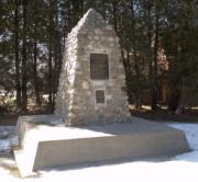
Figure
2: A cenotaph
(left) connects a
community to its past and may also serve as a way to define a village entry
point (Vars). |
|
||||||
|
Guideline
2 |
|
|
||||||
|
Ensure new
development respects
the natural topography of land, and integrates
existing
landforms such as hills, terraces, cliffs, valleys,
rocky
outcrops and watercourses.
Avoid altering natural terrain to accommodate development. |
|
|||||||
|
|
|
|||||||
|
|
|
|||||||
|
Figure
3: The design of a
home (above) takes advantage of an
existing,
natural change in grade
(Kars). |
|
|||||||
|
|
|
|
||||||
|
Guideline
3 |
|
|||||||
|
Avoid
the development
of looping, circuitous,
suburban-style roadway patterns. New
roadway patterns
should be direct and
reflect the traditional
development pattern that exists
in the village
core. Patterns should also provide
multiple
pedestrian,
bicycle and vehicular connections
to adjacent and future development. |
|
|||||||
|
|
|
|||||||
|
Guideline
4 |
|
|||||||
|
If
a direct connection is
not possible, develop
roadways
that terminate onto adjacent open space and/or agricultural land
to create
attractive, natural
view corridors. Ensure
turnarounds provide sufficient space for maintenance
vehicles.
|
|
|||||||
|
|
|
|||||||
|
|
|
|||||||
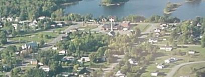
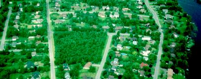
|
Figure
4: An
aerial view (above) shows a modified grid pattern of roads with vistas that
terminate onto Port Fitzroy (Fitzroy Harbour). |
|
|||||||
|
|
|
|||||||
|
Guideline
5 |
|
|||||||
|
Establish a
variety of lot sizes in residential developments.
Creating a mix of lot sizes promotes
a range in
dwelling types
and, in turn,
creates
housing options
for
residents. Explore innovative servicing methods
where lot sizes may be restricted by servicing capabilities. |
|
|||||||
|
|
|
|||||||
|
Guideline
6 |
|
|||||||
|
Develop of mix of housing designs along
neighbourhood blocks to avoid a mass produced or “cookie cutter” appearance.
Varied housing styles, colours and materials create a visually interesting
streetscape and village atmosphere.
|
|
|||||||
|
|
|
|||||||
|
|
|
|||||||
|
Figure
5: Two semi-detached
houses
(above) avoid
a “cookie cutter” look by
having varied designs. The designs also
integrate well with the detached
homes
along the block (Ottawa).
|
|
|||||||
|
|
|
|||||||
|
|
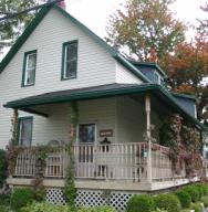
Figure
6: The design of a dwelling (left) successfully balances a familiar village
architectural form while still using modern materials.
(North Gower). |
|
||||||
|
Guideline
7 |
|
|||||||
|
Concentrate
a mix of uses – commercial, residential, recreational and institutional –
within the village core.
Locating
uses within walking distance of each other strengthens
community interaction and viability.
The development of “big-box”
stores on the periphery of the village or just
outside the
village boundaries
is discouraged. |
|
|||||||
|
|
|
|
||||||
|
|
|
|||||||
|
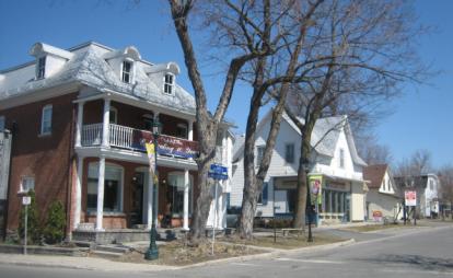
Figure
7:
Businesses and services
(above) are in close proximity
to residential uses in the
village core (Manotick).
|
|
|||||||
|
|
|
|||||||
|
|
Figure
8:
Centrally located community facilities
can function as community gathering places and
allow users who live nearby to walk
(Osgoode).
|
|
||||||
|
Guideline
8 |
|
|||||||
|
Focus
multi-unit residential housing in,
or very close to,
village cores to create an
active pedestrian environment where
residents can support
a
mix of uses and activities. Historic
buildings in the village core should
not be demolished in favour
of developing multi-unit residential housing. Vacant
lots or
underutilized buildings
may offer good
opportunities for residential
infill or residential conversion. |
|
|||||||
|
|
|
|||||||
|
|
|
|||||||
|
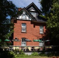
Figure
9: A
heritage building (above) provides multi-unit housing in the village core.
Having a range of residential densities close to amenities and services
provides choice and convenience for village residents (Richmond). |
|
|||||||
|
|
|
|||||||
|
Guideline
9 |
|
|||||||
|
Provide direct pedestrian connections between
adjacent uses within villages to ensure safe and convenient pedestrian
movement. |
|
|||||||
|
|
|
|
||||||
|
|
|
|||||||
|
Figure
10:
Sidewalks along a village mainstreet (above) allow pedestrians and young
cyclists to travel safely (North Gower). |
|
|||||||
|
|
|
|||||||
|
|
Figure
11: Sidewalks
along both sides of a mainstreet (left) facilitates
pedestrian movement and
encourages unplanned exchanges among residents (Richmond). |
|
||||||
|
Guideline
10 |
|
|||||||
|
Ensure
prominent buildings,
open spaces,
public art and/or other
attractive
features are
developed at highly visible locations.
Highly visible locations are
corner sites,
sites that terminate
roadways and sites that frame community gathering places.
Height,
massing, architectural elements and landscaping should
be used to create visual interest. |
|
|||||||
|
|
|
|
||||||
|
|
|
|||||||
|
Figure
12:
A fire station (above) is a
prominent civic building on
a visible corner (Richmond). |
|
|||||||
|
|
|
|||||||
|
Guideline
11 |
|
|
||||||
|
Identify
opportunities to site, stage or install public art in key
locations within the community. Art selection should be done in collaboration
with the community. |
|
|||||||
|
|
|
|||||||
|
|
|
|||||||
|
|
|
|
||||||
|
Guideline
12 |
||||||||
|
Identify, preserve and/
or revitalize community landmarks, focal points
and vistas to support village identity and a ‘sense
of place’. |
||||||||
|
|
|
|||||||
|
|
||||||||
|
Figure
13:
Carp Memorial Hall at a
mainstreet intersection (above)
creates
a distinct vista (Carp). |
||||||||
|
|
|
|||||||
|
|
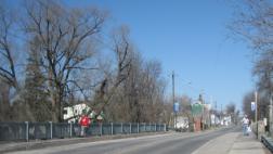
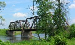
Figure
14:
Preserving important views and iconic cultural landscapes, such as a historic
bridge (left),
contributes
to a unique community identity (Galetta). |
|||||||
|
Guideline
13 |
||||||||
|
Preserve and enhance historic resources such as
heritage buildings and
structures. |
||||||||
|
|
|
|||||||
|
|
||||||||
|
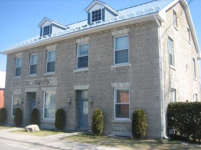
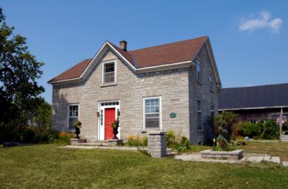
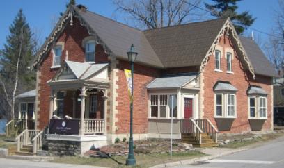
Figure
15:
Although not the
case with all historic resources
to be preserved, the
house (above)
has been designated
by the Ontario
Heritage Act
and dates back to the mid-1800s
(Munster).
|
||||||||
|
|
||||||||
|
|
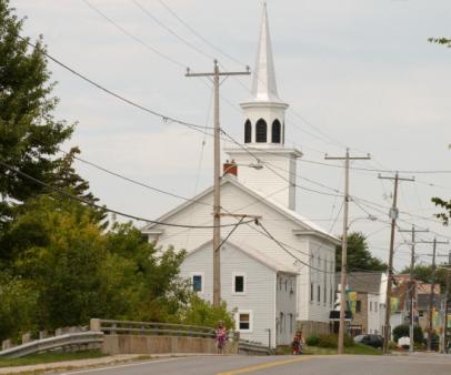
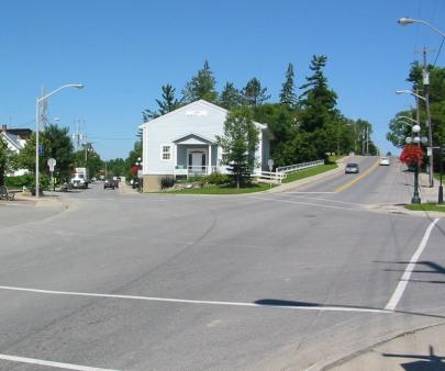
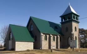
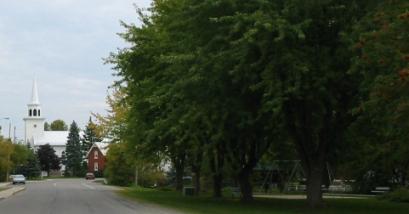
Figure
16:
A historic church (left) has
a place of prominence, located at the end of a main thoroughfare (Burritt’s
Rapids). |
|||||||
|
Guideline
14 |
||||||||
|
Refer
to historic buildings
in the village
for architectural cues,
as redevelopment occurs.
Acknowledging the historic context of the village
facilitates the integration of new development among
existing buildings. |
||||||||
|
|
||||||||
|
|
||||||||
|
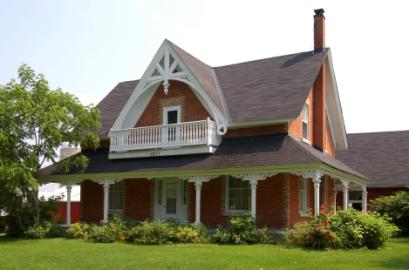
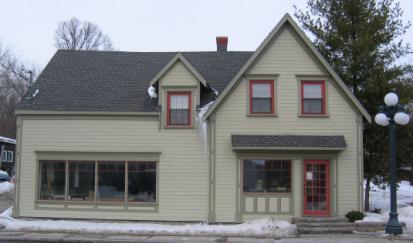
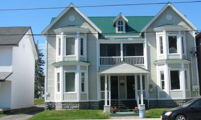
Figure
17:
The dwelling
(above) has
a distinctive roofline, front porch
and masonry.
Historic
buildings can inspire new designs that complement the form, massing
and materials of
past architectural styles
(Cumberland). |
||||||||
|
|
||||||||
|
|
Figure
18:
Architectural features
such as a door
transom, lintels, window
muntins, quoins and materials (left)
show
the character and history of this former
town hall, from
in 1876 (North Gower). |
|||||||
|
Guideline
15 |
||||||||
|
Adapt
old buildings for new uses to
preserve
village history,
landscape and identity. Historic
buildings and sites,
no longer in use, should
be rehabilitated to serve new purposes. |
||||||||
|
|
|
|||||||
|
|
||||||||
|
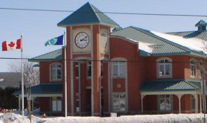
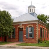
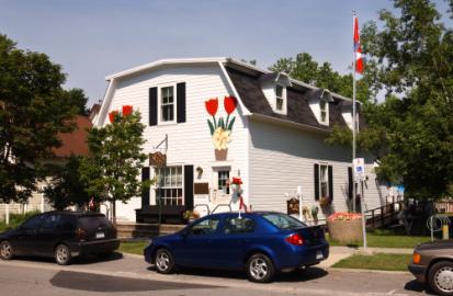
Figure
19:
A
civic building (above),
over 100 years old, is
a former Town
Hall
and now
operates as a municipal office (Metcalfe). |
||||||||
|
|
||||||||
|
|
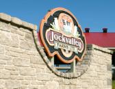
Figure
20:
A historic building in
the village core operates
as a pub
and eatery (Carp). |
|||||||
|
Guideline
16 |
||||||||
|
Adapt
closed
schools
and churches for new
purposes such as specialty schools,
libraries, day
cares, community centres,
youth centres and
recreational centres.
Closed
schools
and churches that
are structurally appropriate, safe and have the
capacity for modification may be good candidates for adaptive reuse. |
||||||||
|
|
||||||||
|
|
||||||||
|
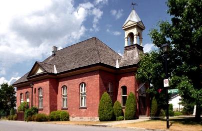
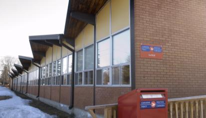
Figure
21: Former
schools
(like
the one above)
offer redevelopment
opportunities
that reduce
sprawl, reduce land
acquisition and construction costs,
revitalize villages and create valuable community resources (Sarsfield).
|
||||||||
|
|
||||||||
|
|
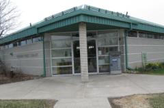
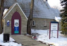
Figure 22:
A former church built in 1886 (left)
currently operates as a public library (Munster). |
|||||||
|
Guideline
17 |
||||||||
|
Ensure
alterations,
additions and renovations
made to
historical buildings
complement
the scale
and character
of the original. |
||||||||
|
|
||||||||
|
|
||||||||
|
Figure
23: A commercial addition (above)
uses the same materials, colours and trims to complement original building
(Carp). |
||||||||
|
|
||||||||
|
|
Figure
24: An
innovative residential
connection
(left) bridges an old building with a
new building using complimentary colours
and durable materials (Manotick).
|
|||||||
|
|
|
|||||||
|
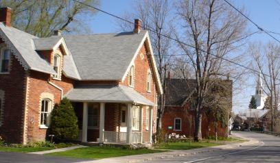
Guideline
18 |
||||||||
|
Consider
using a historic palate with
complimentary colours for new buildings developed in older areas
and village cores. Historic colours can
be rich,
neutral tones inspired by the
original colours found on old village homes and
historical buildings. |
||||||||
|
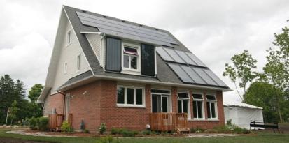
Guideline
19 |
||||||||
|
Reduce
the environmental footprint of buildings
by meeting
or exceeding
environmental and energy efficiency rating standards*,
incorporating renewable or alternative energy systems, maximizing indoor
water efficiency, retaining stormwater on site,
reducing the use
of potable water for irrigation, and reducing resource consumption. |
||||||||
|
|
||||||||
|
|
||||||||
|
Figure 25:
Photovoltaic solar panels, on-site
rainwater
collection and
natural ventilation are
just some of the
sustainable features incorporated
in
Minto’s eco-home
(above) (Manotick). *Examples
of green building and energy
rating standards include LEED Canada
for
Homes,
Energy Star or R2000 construction. |
||||||||
|
|
||||||||
|
|
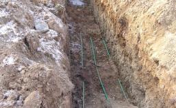
Figure
26: Installation
of a geothermal ground loop system
(left) shows the pipes
that, with the aid of an indoor pump,
will move
heat into or out of the earth to heat or cool a
home
(installation for a home near Munster). |
|||||||
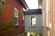
|
Guideline
20 |
||||||||
|
Ensure
new buildings are
compatible with adjacent
development
by using a common scale, massing and
height to
complement the existing context.
New
buildings, including gas stations, should
respond to the village context. |
||||||||
|
|
|
|||||||
|
|
||||||||
|
Figure
27:
A
new home (above, at
left) uses a similar roof pitch, massing,
height and
colour to achieve
compatibility
with the neighbouring
stone heritage
building
(Fallowfield). |
||||||||
|
|
||||||||
|
Guideline
21 |
||||||||
|
In
rare cases where new development is significantly
taller than adjacent development, create
transitions
using built
form. Maintain
a lower
building profile along the street and set
back the
upper storeys,
away from the existing
buildings.
|
||||||||
|
|
||||||||
|
Guideline
22 |
||||||||
|
Avoid
developing buildings with blank
facades
along public rights-of-way.
New
buildings should
follow
the existing
architectural pattern and rhythm
established by adjacent development.
Visually
divide large facades into smaller sections using a
human-scale, windows, bays
and articulation to reduce the perception of massing. |
||||||||
|
|
|
|||||||
|
|
||||||||
|
Figure
28:
A wrap-around porch on a heritage
building (above)
visually divides
the front façade (North Gower). |
||||||||
|
|
||||||||
|
|
Figure
29:
A
historic church (left)
is visually divided into
three segments, which reduces
its perceived
mass
(near
Vars). |
|||||||
|
Guideline
23 |
||||||||
|
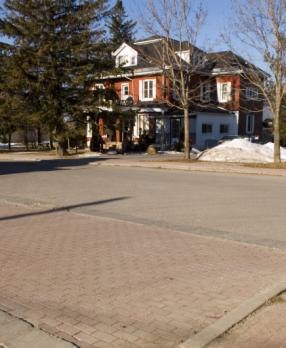
Orient buildings to frame the street. Primary
façades should parallel the street and entries should be clearly visible and
connect to the public sidewalk. |
||||||||
|
|
|
|||||||
|
|
||||||||
|
Figure
30: A residential building (left) is oriented along
a mainstreet and provides a direct pedestrian connection to the sidewalk. A
comfortable setback is also featured (Richmond). |
||||||||
|
|
||||||||
|
Guideline
24 |
||||||||
|
Unless the village core is historically
characterized by a wide variety of setbacks, align new building facades to
create a visually continuous streetscape. |
||||||||
|
|
||||||||
|
|
||||||||
|
Guideline
25 |
||||||||
|
Ensure buildings on corner sites have facades
that address both streets to define the public space. Front and side building
elevations at these locations should incorporate enhanced design, features
and architecture. |
||||||||
|
|
|
|||||||
|
|
||||||||
|
Figure 31:
A historic building on a corner site (above) helps define the public space by
having reduced setbacks, windows, doors and various trims on both streets to
create visual interest (Manotick). |
||||||||
|
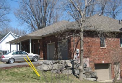
Guideline
26 |
||
|
Set back garages from principal buildings and/or
locate parking
to the side or rear of principal buildings.
Proper orientation of parking mitigates
its impact
on the public street. |
||
|
|
||
|
|
||
|
|
||
|
|
||
|
|
||
|
|
||
|
|
||
|
|
||
|
Figure
32: Laneway (above,
at left) provides access to rear parking for housing
along the mainstreet in a village core (Metcalfe). |
||
|
|
||
|
Guideline
27 |
||
|
Enhance gathering places by including design
elements such as play areas, landscaping, street furniture, public art and/or
other attractive
features that reflect community character. Gathering places have activities
and/or services that promote safe community interaction, exchange and congregation. |
||
|
|
|
|
|
|
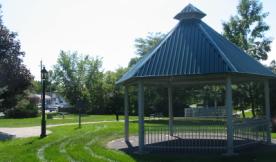
Figure 33:
A centralized park (left) has a gazebo, bench, bridge and themed lighting
that adds interest
and invites
people in (Metcalfe). |
|
|
Guideline
28 |
|
|
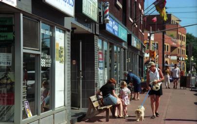
Develop lively
frontages along mainstreets to support pedestrian
activity. Lively, active
frontages may be characterised by a human-scale, reduced building setbacks,
visible entries, wide sidewalks, highly transparent facades, patios and
varied decorative paving. Clearance
requirements for at-grade and overhead utility distribution equipment
shall be respected. |
|
|
|
|
|
|
|
|
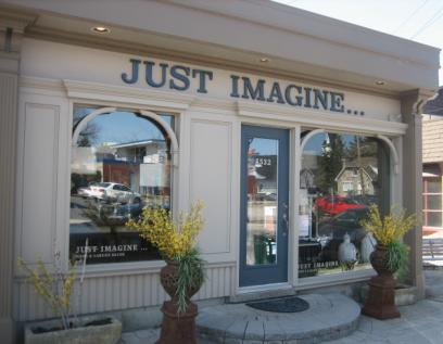
Figure
34: Human-scale architecture, wide
sidewalks and a mix of land uses help create an active
streetscape (above) (Ottawa). |
|
|
Guideline
29 |
|
|
||||||||
|
Where possible, cluster utilities together to
minimize visual impact. When determining locations for large utility
equipment and cluster sites, utility providers are encouraged to consider
innovative methods of containing utility services on, or within streetscape
features such as gateways, lamp posts and transit shelters. |
|
|||||||||
|
Guideline
30 |
|
|||||||||
|
Develop generous sidewalks on both sides of the
streets for mainstreets, village cores and areas with high pedestrian traffic
(for example, near schools) to promote walkability. Sidewalks on both sides
of the street facilitate safe, easy and convenient pedestrian travel to
community amenities. Sidewalks should be wide enough to accommodate
maintenance vehicles and snow storage. |
|
|||||||||
|
|
|
|||||||||
|
Guideline
31 |
|
|||||||||
|
Develop crosswalks along mainstreets to have
contrasting paving or impressed concrete to make them visually different from
the street. |
|
|||||||||
|
|
|
|
||||||||
|
|
Figure
35:
Crosswalks and sidewalks in
a village core (left) contrast the roadway and help define the pedestrian
area (Vars). |
|
|
|||||||
|
Guideline
32 |
|
|||||||||
|
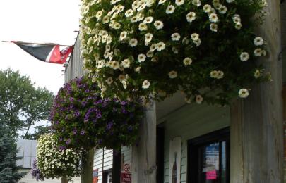
Encourage the use of awnings, seasonal plantings
and/or signage in storefront design along mainstreets to add visual interest
to streetscape. Attachments made to hydro poles shall follow the requirements
of affected utility providers. |
|
|||||||||
|
|
|
|||||||||
|
|
|
|||||||||
|
Figure
36:
Seasonal hanging baskets (above) add interest to the streetscape (Kars). |
|
|||||||||
|
|
|
|||||||||
|
|
Figure
37:
Awnings
and
a planter
(left) enhance
a residential building
façade (Constance
Bay). |
|
||||||||
|
Guideline
33 |
|
|||||||||
|
Ensure signage is made of high-quality, durable
materials that complement the architectural surroundings. Sign
illumination should be task-oriented and avoid glare/light spillover toward
adjacent land uses. |
|
|||||||||
|
|
|
|||||||||
|
|
|
|||||||||
|
Figure
38:
Storefront signage (above) uses durable materials and is mounted within the
façade’s architectural signage band (Manotick). |
|
|||||||||
|
|
|
|||||||||
|
|
Figure
39:
A monument, ground mounted sign (left) uses high-quality materials
such as stone and wood, and showcases its artistic craftsmanship (Ashton). |
|
||||||||
Guideline
34 |
|
|||||||||
|
Provide consistent, human-scaled, decorative
street lighting along village mainstreets to create a distinct character,
to animate the area and to
minimize glare. |
|
|||||||||
|
|
|
|
||||||||
|
|
|
|||||||||
|
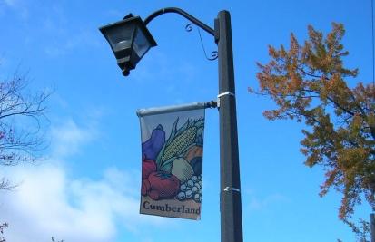
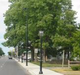
Figure
40:
Consistent
street lighting and banners along key streets (above) creates a community
identity (Cumberland). |
|
|||||||||
|
|
|
|
||||||||
|
|
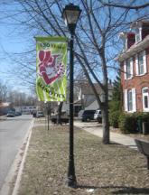
Figure
41:
Consistent street
lighting creates
a distinct streetscape and seasonal banners communicate a
village
message (left)
(Manotick).
|
|
||||||||
|
Guideline
35 |
|
|||||||||
|
Unless the village core is historically
characterized by a variety of street tree plantings, plant deciduous trees in
a consistent pattern along both sides of the street in areas with pedestrian traffic.
Street trees define the street edge, and protect and shade pedestrians.
Consider planting trees behind sidewalks, away from the road edge, to
increase the tree’s chance of survival. Ensure that tree planting is
coordinated with the installation of utility distribution poles. |
|
|||||||||
|
|
|
|
||||||||
|
|
|
|||||||||
|
Figure
42:
Trees define one side of a road (above), provide
visual interest and enclose a park space (North Gower). |
|
|||||||||
|
|
|
|||||||||
|
|
Figure
43:
Trees (left) define the street edge and add shade and biodiversity to the area
(Richmond). |
|
||||||||
|
Guideline
36 |
|
|||||||||
|
In consultation with the community, incorporate
traffic calming measures such as curb and median extensions, pedestrian
refuges and raised crosswalks in village cores and along main streets. |
|
|||||||||
|
|
|
|
||||||||
|
|
|
|||||||||
|
Figure
44:
A variety of elements such as on-street parking,
boulevards, contrasting paving, bollards, lighting and street trees (above)
can be used to identify a pedestrian environment and calm traffic
(Brockville). |
|
|||||||||
|
Guideline
37 |
|
|||||||||
|
Consider providing on-street parking along
mainstreets and/or
in the village core to calm traffic,
lower vehicle
speeds and
create a more walkable village atmosphere. |
|
|||||||||
|
|
|
|
||||||||
|
|
|
|||||||||
|
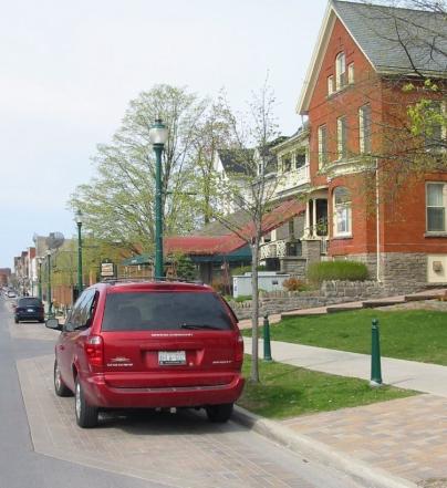
Figure
45:
On-street parking (above) creates a sense of enclosure for pedestrians and
may off-set site parking requirements (Manotick). |
|
|||||||||
|
Guideline
38 |
|
For small
commercial lots
in the village core, seek reduced parking requirements
to facilitate redevelopment.
Additionally, look
for opportunities to
share parking with adjacent land
uses. |
|
Guideline
39 |
|
Plant landscaped buffers for parking lots that
are adjacent to,
or visible from,
public rights-of-way. |
|
Guideline
40 |
||||
|
Ensure
the
pedestrian and cycling network
is continuous and connects to the
village core
and village destinations.
Protect
connections
that can be filled-in
over time as development and redevelopment permits,
and ensure existing
connections are
not closed
or disconnected. |
||||
|
|
||||
|
Guideline
41 |
||||
|
Connect
and integrate natural
areas such as lakes, rivers and wetlands,
and stormwater management ponds
into the
pedestrian and
cycling network.
Where possible,
include opportunities for passive recreation such as hiking trails and
seating areas |
||||
|
|
|
|||
|
|
||||
|
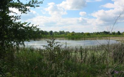
Figure
46:
A wastewater treatment lagoon, close to a village downtown
(above), has been converted into a conservation area and
bird sanctuary (Richmond).
|
||||
|
|
||||
|
Guideline
42 |
||||
|
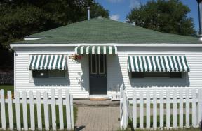
Design trails and pathways to match
the aesthetic and function of their
surrounding space. |
||||
|
|
|
|||
|
|
||||
|
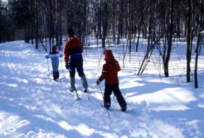
Figure
47:
The
trail above
is not
groomed and very naturalized;
it matches the aesthetic and function of its
forest surroundings. This trail
makes use of open spaces and provides
recreational opportunities
in a rural area (Greenbelt). |
||||
|
|
||||
|
|
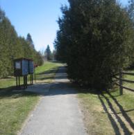
Figure
48:
The pathway (left) is manicured and well
maintained, which supports its function
as a direct
connection and mailbox access
(Fallowfield). |
|||
|
Guideline
43 |
||||
|
Retain healthy mature trees,
hedgerows and historic forests
and incorporate them into development, park space and community designs. |
||||
|
|
|
|||
|
|
||||
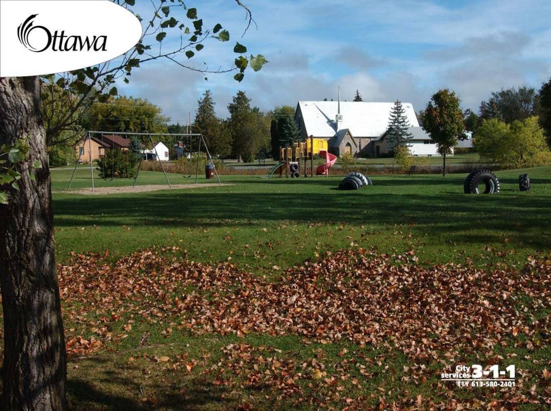
|
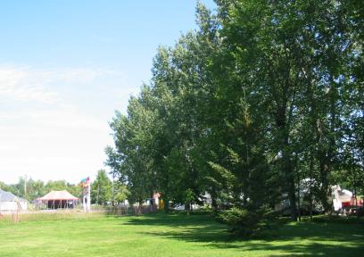
Figure
49:
A
neighbourhood park incorporates existing trees, which enhances
it considerably,
provides
shade and divides
fields (Kars). |
||||
|
|
||||
|
|
||||
|
Figure
50:
A healthy
village tree
stand (above) is
preserved (Manotick). |
||||
Adaptive
reuse: the rehabilitation of buildings
for new purposes
Awning:
a canvas
covering
that provides
shelter and is attached
to an exterior wall, over a window or door
Biodiversity: the
abundance of different plant and/or
animal species
found in an environment
Bollard: a
strong, vertical post
Character:
a unique, identifiable physical form associated
with buildings and/or villages
Compatible
/ Compatibility: when the density, form, bulk, height, setbacks,
and/or materials of buildings are similar relative able to co-exist with to
their surroundings.
'Compatible'
does not mean 'the same as'
Eclectic:
design elements from multiple sources, styles,
dates and influences
Entry
point:
a main point of entrance into a community and
a good location for a feature
Façade:
the principal face of a building (also referred to as the front wall)
Frame: structures
aligned
to enclose or define a
space
Heritage:
Buildings, structures, sites, landscapes, areas and
environments of historic, architectural, contextual, cultural and/or natural
interest, which are or should be conserved for the benefit of the community and
posterity
Human
scale: a size of a building or space that a human
perceives as not dominating or overpowering
Identity: unique
tangible or intangible traits
that make a village definable or recognizable,
and that distinguishes
it from others
Infrastructure:
Physical
structures (facilities and corridors) that form the
foundation for development. Infrastructure includes: sewage and water systems,
septage treatment systems, waster management systems,
electrical power generation and transmission, communications
/telecommunications,
transit and transportation corridors and facilities, and oil and gas pipelines
and associated features.
Landform:
a natural landscape feature such as mounds, hills,
cliffs, caves, valleys, beaches, marshes, lagoons,
lakes
Landmark: elements
that create distinct visual orientation points, and provide a sense of location
Lintel:
a structural or
decorative horizontal element over
a door or window
Low-density
development: having
a low concentration of housing units, typically single and semi-detached
dwellings, in a specific area
Massing:
the perception a building’s external shape or form
Modified
Grid: a network of roads in a grid pattern, modified to
incorporate curves to address topography and/or existing development
constraints
Monotonous:
tediously repetitive, boring
or lacking variation
Muntin:
a strip of medal or wood separating windowpanes
Natural
areas:
physically tangible elements of the environment
including wetlands, forests, ravines, rivers, valleys and associated wildlife
habitats
Passive
recreation: recreational activities that take advantage of the
existing, natural environment such as hiking,
horseback riding, cross country skiing, bird watching, etc.
Prominent
building: a
conspicuous building in a place of importance
or high visibility
Quoin:
a dressed
stone that
forms
the external corner
of a building
Revitalize:
to restore new life or energy to an area
Rhythm:
a visual repetitiveness of architectural
elements to establish a pattern
Scale:
the size of a building or an architectural feature in relation to its surroundings
and to the size of a person
Sense
of Place: a
component of ‘village identity’,
is an
individual’s perception or response to the
built and/or natural environment
Setback:
the required distance from a road, property line, or another structure, within
which no building can be located
Sidewalk:
unobstructed concrete or paved area for pedestrian travel in the public
right-of-way
Streetscape:
the overall character and appearance of a street formed by buildings and
landscape features that frame the public street. Includes building façades,
street trees, plants, lighting, street furniture, paving, etc.
Traffic
calming: physical measures designed to slow traffic and
improve the pedestrian environment
Transom:
a glassed
opening installed over a door or window
Utilities:
A public body or private corporation, together with
their associated physical infrastructure, that provides services to the public,
such as hydro, natural gas, communications
/ telecommunication, cable and sewer and water
Village
core: The historic
settlement of a village,
the heart, social centre and
the focus of economic activity.
An important area to highlight or intensify at key intersections and gateways
Visual
harmony: elements of design that visually unify or make
compatible
Vista:
refers to what can be seen from a particular location, such as a significant
building and/or landscape feature
Walkability:
the extent to which the environment supports
an ease of walking