|
7. NICHOL'S ISLAND ROAD REHABILITATION AND LOCAL
IMPROVEMENT RÉFECTION DE LA CHAUSSÉE DU CHEMIN NICHOL’S ISLAND ET AMÉNAGEMENT LOCAL |
Committee RecommendationS
That Council approve:
1. A by-law to undertake the bank stabilization and road
rehabilitation of Nichol's Island Road as a petitioned Local Improvement and in
accordance with the cost apportionment outlined in this report, subject to an
agreement being concluded between the City and Parks Canada to address cost
sharing for these works as well as the required land transfers and
acquisitions, as further described in this report.
2.
The purchase of the real
property at 5158 Cecil Rowat Lane, required to provide legal access for Fire
Department Vehicles, emergency, and other heavy vehicles to Nicolls Island, and
to provide a river crossing for the City’s recreational pathway network from
George MacFarlane, for the total consideration of $1,130,000 plus reasonable
legal fees related to the transaction.
RecommandationS du Comité
Que le Conseil approuve:
1. un
règlement en vue d’entreprendre la stabilisation du bord du chemin Nichol’s
Island et la réfection de la chaussée à titre de travaux d’amélioration locale
et conformément à l’imputation des coûts exposée dans ce rapport, sous réserve
de la conclusion d’un accord entre la Ville et Parcs Canada portant sur la
répartition des coûts de ces travaux ainsi que sur les transferts et
acquisitions de terrains et cessions qui seront nécessaires, comme il est
décrit plus loin dans ce rapport.
2. l’achat
du bien réel du 5158, ruelle Cecil-Rowat requis afin de donner un accès légal
aux véhicules du Service des incendies, en cas d’urgence et aux autres
véhicules lourds à l’île Nichols, et de fournir un passage de la rivière au
réseau de sentiers récréatifs de la Ville, à partir de George MacFarlane, pour
un montant total de 1 130 000 $ plus les frais juridiques liés à la
transaction, et ce, sous réserve de la conclusion de l’accord de la
recommandation 1.
Documentation
1.
Deputy
City Manager's report Infrastructure Services and Community Sustainability
dated 4 September 2009 (ACS2009-ICS-PGM-0176).
.
Report to/Rapport au :
Agriculture and Rural
Affairs Committee
Comité de l'agriculture et des questions rurales
and Council / et au Conseil
11 September 2009 / le 11 septembre 2009
Submitted by/Soumis par : Nancy Schepers, Deputy City Manager/
Directrice
municipale adjointe,
Infrastructure
Services and Community Sustainability/Services d’infrastructure et Viabilité
des collectivités
Contact Person/Personne-ressource : Derrick Moodie, Manager/Gestionnaire,
Development Review-Rural services/Examen des projets d'aménagement-Services
ruraux,
Planning and
Growth Management/Urbanisme et Gestion de la croissance
(613) 580-2424, 15134 Derrick.Moodie@ottawa.ca
SUBJECT:
|
|
|
|
|
OBJET :
|
RÉFECTION DE LA CHAUSSÉE DU CHEMIN NICHOL’S ISLAND ET AMÉNAGEMENT LOCAL |
REPORT RECOMMENDATIONS
That the Agricultural and Rural Affairs Committee
recommend Council approve:
1. A by-law
to undertake the bank stabilization and road rehabilitation of Nichol's Island
Road as a petitioned Local Improvement and in accordance with the cost
apportionment outlined in this report, subject to an agreement being concluded
between the City and Parks Canada to address cost sharing for these works as
well as the required land transfers and acquisitions, as further described in
this report.
2. The
purchase of the real property at 5158 Cecil Rowat Lane, required to provide
legal access for Fire Department Vehicles, emergency, and other heavy vehicles
to Nicolls Island, and to provide a river crossing for the City’s recreational
pathway network from George MacFarlane, for the total consideration of
$1,130,000 plus reasonable legal fees related to the transaction.
RECOMMANDATIONS DU RAPPORT
Que le Comité de l’agriculture et des questions rurales recommande au Conseil d’approuver :
1. un
règlement en vue d’entreprendre la stabilisation du bord du chemin Nichol’s
Island et la réfection de la chaussée à titre de travaux d’amélioration locale
et conformément à l’imputation des coûts exposée dans ce rapport, sous réserve
de la conclusion d’un accord entre la Ville et Parcs Canada portant sur la
répartition des coûts de ces travaux ainsi que sur les transferts et
acquisitions de terrains et cessions qui seront nécessaires, comme il est
décrit plus loin dans ce rapport.
2. l’achat
du bien réel du 5158, ruelle Cecil-Rowat requis afin de donner un accès légal
aux véhicules du Service des incendies, en cas d’urgence et aux autres
véhicules lourds à l’île Nichols, et de fournir un passage de la rivière au
réseau de sentiers récréatifs de la Ville, à partir de George MacFarlane, pour
un montant total de 1 130 000 $ plus les frais juridiques liés à la
transaction, et ce, sous réserve de la conclusion de l’accord de la
recommandation 1.
BACKGROUND
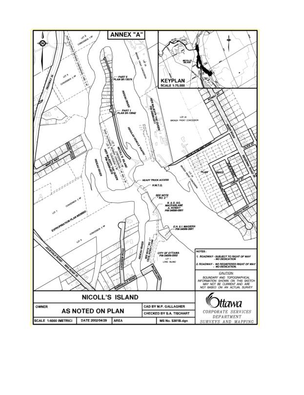
Nicolls Island was created by the construction of the Rideau Canal and is located in the Rideau River, north of the Village of Manotick, as shown on the attached drawing. A concrete dam running from the north end of Long Island to the south end of Nicolls Island limits water flow in the western channel providing water depth for the eastern channel that consists of the Long Island Locks, situated between Nicolls Island and the East bank of the Rideau River. While the island is named 'Nicolls Island' the name of the road that is the centerpiece of this report is referred to by the federal government as 'Nichol's Island Road.' This report maintains the two spellings, but as steps have been taken to correct this inconsistency, these two spellings should be considered interchangeable.
In the 1930s, the Federal Government subdivided the northerly portion of the island and sold 17 of 19 building lots for summer cottages that over time have been converted to full time residences. A strip of land 6.1 metres wide was set out on the plan to provide a “road access” to the properties and remains in the ownership of the Federal Government, but provides no registered rights to the residents. Regular light vehicular access (up to 4.5 tonnes) to the properties is from River Road to the east, along the mainland portion of Nichol's Island Road across Federal Lands on the eastern bank and then over the Long Island Lock Bridge. Heavy and emergency vehicle access to the Nicolls Island is from Long Island to the south, from McLean Crescent, through a City park, along the private Cecil Rowat Lane, across private property and Federal Lands, and then across the concrete dam linking the two islands.
Nichol's Island Roadway
The road on Nicolls Island is approximately seven metres to nine metres higher in elevation than the high water mark of the Rideau River. The portion of the road within the subdivision bisects the southerly 13 lots with the homes located on the west side and with small remnant parcels owned by the residents on the east side. The former Township of Rideau held discussions with the Federal Government regarding maintenance of the road in the early 1980s. In 1985, after residents approached the Township requesting that the road be upgraded, ownership of the road was included as a topic of those discussions. At that time the Federal Government was unwilling to transfer ownership of the road to the Township and no transfer agreement was made. However, they did enter into a License Agreement with the Township dated January 1990, dealing with maintenance requirements for the road as an interim measure pending completion of discussion on a possible transfer of the road. In the License, the Township agreed to “maintain the roadway in a satisfactory state of repair;” however, the agreement did not define “maintain,” had no specified term and was subject to cancellation by either party “forthwith at any time” by notice in writing. The road has never been conveyed or officially dedicated to the municipality. Surveys and Mapping has confirmed that the Federal Government is identified in the Land Titles Office as the registered owner of the road.
The issue of the ownership of the Nichol's Island Road is not conclusive, and has been a debated point between the City and Parks Canada. It is the position of the City, and that of the former Rideau Township, that the roadway remains a federal road. Legal issues related to the ownership of the roadway are more fully discussed in the accompanying memorandum from Legal Services.
Slope Stabilization
In 1991, the east riverbank slope near the road experienced a partial failure. The Rideau Valley Conservation Authority (RVCA) commissioned a report from the engineering consultant John D. Patterson and Associates who recommended bank stabilization works to prevent a catastrophic failure. The Township unsuccessfully attempted to negotiate a cost sharing agreement between the RVCA, the residents and the Province. In May of 1996, the Township retained the law firm Lang Michner to provide advice on the Township’s responsibilities and liabilities in light of the slope failure. Upon amalgamation, the former Township of Rideau brought the file forward as a priority issue to the new City of Ottawa.
Over the last few years, the road has deteriorated due to erosion causing the instability of the steep seven-metre to nine-metre high slope located between the road and the Rideau River. Recent engineering studies have suggested that the slope beside the road will eventually fail, collapsing the road and eliminating road access to most of the lots in the subdivision. Extensive slope stabilization works on the east side of the Island will be required with any road rehabilitation to ensure the long-term integrity of the road.
Emergency and Heavy Vehicle Access
Emergency vehicle access to Nicolls Island is across a private property located at the northern tip of Long Island. The owner of the property has allowed emergency and heavy vehicles across his lands but has carefully limited the access to prevent the formation of any claim for prescriptive rights. The City enjoys no legal right to cross the property and does so only with the case-by-case permission of the owner.
The property contains a heritage structure and enjoys a legal non-conforming right to residential use. A confidential appraisal of the property has been obtained, as noted in the confidential memorandum from Legal Services that accompanies this report. The property is in a unique location and is surrounded by parkland with waterfront on two sides
The issue of obtaining a long-term heavy vehicle access to the Island remains of significance to the City in order to ensure that fire services can be delivered in the most efficient and timely manner to the Island. Legal issues related to the provision of fire services to the Island are more fully discussed in the accompanying memorandum from Legal Services.
DISCUSSION
Funding for this project was approved as part of the 2009 Capital Budget based on a proposal that includes shared costs for bank stabilization and road repair, land acquisitions and transfer and provisions for enhanced fire fighting infrastructure on Nicolls Island. This proposal will resolve the ongoing concerns relating to:
- the condition of river bank and Nichol's Island Road.
- the ownership of Nichols Island Road
- Emergency and Heavy Vehicle Access to the Island
In addition, the proposal will provide the following enhancements:
- Improved water supply infrastructure for fire fighting on the island
· Improved connections for cycling and pedestrian networks through securing additional access across the Rideau River
- Additional 21 acres of parkland within the City's inventory, including 1.6km of shoreline
- Protection of a heritage structure
- formalized access agreements across federal lands
Bank Stabilization and Road Reconstruction - Local Improvement
The proposed cost sharing formula requires both the City and Parks Canada to each pay 45 per cent of the projected costs with Nicolls Island residents collectively paying 10 per cent of the estimated $1,215,000 cost to stabilize the riverbank and reconstruct the road to an acceptable standard.
The residents owning remnant parcels of land on the east side of the Island that are subject to slope failure have agreed to convey those remnant parcels to the City at a nominal cost so the City would not be conducting slope stabilization works on private land and would have long-term access for maintenance and protection of the slopes.
The resident's 10 per cent contribution to the works will be raised through Local Improvement. The petition process was undertaken in accordance with the Municipal Act, 2001 and the City’s Local Improvement Policy, approved by Council in 2006 (Ref. No: ACS2006-PWS-INF-0001). This was a community driven process. Staff facilitated the process by defining the petition limits, preparing cost estimates for the work, defining City and owner share of costs, attending information sessions and ultimately preparing the petition documents and individual property owner information packages once the lead petitioner confirmed a desire to proceed (refer to Document 1)
To be successful a petition requires support of two thirds of the property owners representing 50 per cent of the value of all lands in the petition area. To proceed to implementation, a By law approved by Council is required confirming the works are to proceed with cost recovery from the benefiting property owners in accordance with the Municipal Act, 2001.
The petition limits included all of the 17 existing lots containing 21 residential properties on Nicolls Island. As a result of significant community effort, a petition for bank stabilization and road reconstruction has been submitted and certified by the City Clerk as sufficiently signed pursuant to the provisions of Ontario Regulation 586/06 of Municipal Act 2001. The works petitioned will be subject to cost sharing agreement, as described in this report, between the City, Parks Canada, and the residents.
The petition documents were certified by the City Clerk on 5 August 2009 as having been sufficiently signed by 100 per cent of property owners representing 100 per cent of the assessed value of all properties in the petition area. The petition documents contain provisions that the works themselves are subject to final approval by Council.
Emergency and Heavy Vehicle Access
The subject property known as the MacFarlane lands contains about 7,540 square meters of land improved with a two-story house and outbuildings, located at 5158 Cecil Rowat Lane as shown on Document 2. The property is the northernmost tip of Long Island in the former Village of Manotick and is connected to Nicolls Island to the North, by way of the concrete dam that forms part of the Rideau Canal infrastructure. Negotiations have resulted in a purchase and sale agreement with the owner for a total consideration of $1,130,000 plus reasonable legal fees related to the transaction. The value is consistent with an independent appraisal commissioned by the City and is confirmed by an internal appraisal performed by in house professional appraisers. As part of the agreement, the City will apply to have a geographic feature of the land named in honour of the owner’s pioneer ancestors, subject to the approval Commemorative Naming Committee. The cost for this transaction is to be borne entirely by the City.
An agreement has also been reached in principle with Parks Canada to reflect that in exchange for the City obtaining heavy vehicle access by acquiring the MacFarlane lands, the federal Government will contribute riverfront parkland, rather than a monetary contribution to the City. This parkland consists of 2.2 hectares located in Beryl Gaffney Park and about 6.3 hectares located on Nicolls Island. The lands will be conveyed through long term lease (40 years) under the condition that they remain as rustic parkland in keeping with the mandate of Park Canada to preserve the land adjacent to the World Heritage Rideau Canal. This transfer of the land also complies with the Official Plan with respect to the preservation of Rideau River shoreline and will fit in with the rustic parkland of Beryl Gaffney Park, situated across the west channel from the Nicolls Island. The transfer of these lands from the federal land inventory has received clearance from the Algonquin First Nation and approval from Treasury Board is anticipated prior to this report being considered by Committee and Council. Parks Canada will also assist with required approvals for a dry/remote hydrant system for fire protection purposes.
The house located on the MacFarlane lands is included on the City's Heritage Reference List. It was constructed by the Rowat family, long-time lockkeepers and farmers at the adjacent Long Island Lock and is still owned by descendants of the builder.
Sources say that William Rowat built the house circa 1860. As an early dwelling along the canal linked to a prominent family, it meets the minimum criteria for designation under Part IV of the Ontario Heritage Act and further research on its history and condition should be undertaken prior to the final decision regarding its future.
The MacFarlane lands have also been identified in the Official Plan, the Greenspace Master Plan and several open space studies as a critical open space and pathway connection across the Rideau River. This property would serve as a keystone in an arch of extensive public open spaces that span the Rideau River basin in the southern urban area. This potential connection links large city parks and open spaces in Nepean South, Manotick and Riverside South into a continuous system of public open spaces. These parks include: Beryl Gaffney Park, David Bartlett Park, the Long Island Locks and Jeffery Armstrong Memorial Park. This important recreational pathway link will provide the only river crossing between Hunt Club Road and Bridge Street in Manotick. The property would improve public access to open space that serves an existing population of over 65,000.
Delegation of Authority
Council approved the Mid-Term Governance Review Report on June 24, 2009. The recommendations of the report provide for greater delegated authority for those transactional items related to identifiable wards where staff have worked with the stakeholders and the Ward Councillor to resolve any identified issues and the Ward Councillor agrees with the proposed courses of action. However, in the “Process for Delegation” section found in part A. Delegation of Powers to Standing Committees and Ward Councillors, the Report states as follows:
“If Council adopts these recommendations, including the changes outlined below, specific processes for each delegation, including timelines, will be established by staff and brought to the appropriate Standing Committee for review and approval.”
In the case of the Nicolls Island Project, a separate delegation process will not be provided for Committee review given that this is a long-standing project and the Ward Councillor is in agreement with the related transactional items (enumerated in the Disposition section), as are the residents of the Island. A funding contribution has been negotiated with Parks Canada, and the relevant agreements are being finalized. Funding for the remaining transactional items is within the funding envelope approved by Council for this project as part of the 2009 budget. As such, staff are of the opinion that these transactional items fall within the Mid-Term Governance Review’s intended delegations of authority to staff where Ward Councillor approval is concurring and funding is available. In addition, given the necessity to complete the design and obtain all permits, approvals and agreements, it is necessary to proceed as quickly as possible.
ENVIRONMENTAL IMPLICATIONS
This initiative will stabilize the banks of the Rideau River adjacent to Nichol's Island Road, preventing future erosion and potential collapse of the banks.
RURAL IMPLICATIONS
This project will resolve a long standing issue in the rural area and provide additional benefit in enhanced fire service, pedestrian and cycling infrastructure.
CONSULTATION
Extensive consultation has taken place with the residents of Nicolls Island, Parks Canada, Department of Justice, the Ward Councillor and Member of Parliament and relevant City Departments.
The Ward Councillor provided the following comment: "After decades of delay, I want to thank the City staff for their assistance. Further, I want to say many thanks to my Council colleagues for their foresight and support. To Ian Hawtry, Mayor of Nicolls Island, your tenacity is now being well rewarded."
LEGAL/RISK MANAGEMENT IMPLICATIONS:
Legal and risk management implications for this project are more specifically outlined in the Confidential Legal Memo which is being circulated separately.
The agreement between the City and Parks Canada which is presently being finalized adequately addresses the legal and risk management issues associated with this project.
FINANCIAL IMPLICATIONS
Funds are available as approved in the 2009 Capital Budget, Order No. 902630 and 905110 (Nichols Island Road).
|
|
$ |
$ |
|
|
902,630 |
905,110 |
|
Approved Budget to Date |
100,000 |
1,600,000 |
|
Total Paid and Committed |
(3,356) |
(138,330) |
|
Balance Available |
96,644 |
461,670 |
The works directly related to the bank stabilization and road works are estimated to cost $1,215,000 and are subject to a cost sharing agreement with the City (45 per cent - $546,750), Parks Canada (45 per cent - $546,750) and the residents (10 per cent - $121,500). The resident's portion will be raised through Local Improvement charges, as per Ontario Regulation 586/06 of Municipal Act 2001.
Upon completion of the construction project the road and bank will require minimal repairs. The City is already providing winter maintenance of Nichol's Island Road. There is not anticipated to be any significant change to ongoing operational costs as a result of this report.
Acquisition costs relating to securing emergency and heavy vehicle access, totalling $1,130,000, through the MacFarlane Lands are entirely the responsibility of the City, however, in return Parks Canada will grant a long term lease (40 years) to the City for parkland on Nicolls Island and adjacent to Beryl Gaffney Park.
The total project costs of $1,700,000 are currently funded by Tax Debt ($1,645,000) and General Revenue ($55,000). Once the cost sharing agreements with Parks Canada and the residents are finalized the projects will be amalgamated and a budget adjustment will be processed to recognize the above contributions from other sources.
Project Costs/Contributions
|
|
City of Ottawa |
Parks Canada |
Residents |
Total |
|
Road Reconstruction |
$ 546,750 |
$546,750 |
$121,500 |
$1,215,000 |
|
Heavy Vehicle Access – Property acquisition |
$1,130,000 |
N/A |
N/A |
$1,130,000 |
|
Land contributions |
N/A |
21 acres |
Remnant parcels |
|
|
Total Cash |
$1,676,750 |
$546,750 |
$121,500 |
$2,345,000 |
SUPPORTING DOCUMENTATION
Document 1 Local Improvement Information Package
Document 2 Nicoll's Island Map
Document 3 Confidential Legal Memo Regarding Nicolls Island (This document is Confidential as it contains information relative to: (1) The receiving of advice that is subject to solicitor client privilege, including communications necessary for that purpose, and (2) A proposed or pending acquisition of land for the purposes of the City.)
DISPOSITION
Upon approval of this local improvement charge by Council, staff from Legal Services will place the appropriate Local Improvement Charge By-law on Council’s Orders of the Day.
Upon approval of this local improvement charge, staff will also undertake the following work and transactions for the balance of the requirements of the Nicolls Island project, the funding for which had previously been approved in the 2009 Budget:
1. If Treasury Board approves the proposed cost-sharing arrangement, the City Manager (or his delegate) will take the necessary steps to conclude an agreement with Parks Canada for the cost sharing of the roadway rehabilitation of Nichol's Island Road and related slope stabilization work on the basis that the apportionment of the total cost will be 45 per cent for the City, 45 per cent for Parks Canada, and 10 per cent for the residents of Nicolls Island (by way of the local improvement charge which is the subject of this Report);
2. The Director of Infrastructure Services will then initiate a competitive process (tender) and conclude all agreements and transactions necessary to complete the required road rehabilitation and slope stabilization work required for the Nichol’s Island Road, including design work, roadway reconstruction and slope stabilization;
3. Staff will take the necessary steps to acquire the Nichol’s Island Road at the time of the commencement of the construction work;
4. Staff will take the necessary steps and conclude the necessary agreements and transactions for the acquisition of the privately-owned lands on the northern end of Long Island in order to ensure heavy vehicle access to Nicolls Island, for a sum that is within the budget approved for the Nicolls Island Project;
5. Staff will take steps and conclude the necessary agreements and transactions to acquire, at a nominal fee, the privately-owned small parcels of land on the East-side of Nicolls Island adjacent to the roadway for construction purposes and in order to ensure future stability and monitoring of the roadway and of the slope works;
6. Staff will conclude the necessary easements and rights-of-way agreements and transactions, for a nominal fee, to ensure a long-term right of access for the City to and within Nicolls Island over Federally-owned infrastructure, and also reciprocally to allow Parks Canada to cross over City-owned lands; and
7. Staff will conclude the necessary agreements and transactions to acquire, for a nominal fee, a long-term lease to the benefit of the City for parkland located in Beryl Gaffney Park (approximately 2.2 hectares) and on Nicolls Island (approximately 6.3 hectares) to be used and operated by the City solely as rustic public parkland with passive uses.
LOCAL IMPROVEMENT INFORMATION PACKAGE DOCUMENT 1
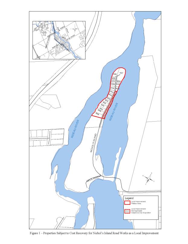
NICOLL’S ISLAND MAP DOCUMENT
2