|
3 COMPREHENSIVE ZONING
BY-LAW - AMENDMENTS TO SECTION 69 – SETBACK FROM WATERCOURSES AND WATERBODIES
AND AMENDMENTS TO THE ZONING OF LAND LOCATED ALONG THE OTTAWA RIVER BETWEEN
THOMAS A. DOLAN PARKWAY AND THE BOUNDARY WITH THE TOWN OF ARNPRIOR RÈGLEMENT
DE ZONAGE GÉNÉRAL – MODIFICATIONS À L’ARTICLE 69 – RETRAIT DES COURS D’EAU ET
DES PLANS D’EAU ET MODIFICATIONS AU ZONAGE DES TERRAINS SITUÉS LE LONG DE LA
RIVIÈRE DES OUTAOUAIS ENTRE LA PROMENADE THOMAS A. DOLAN ET LES LIMITES DU
VILLAGE D’ARNPRIOR |
planning and environment committee recommendations
That Council
approve:
1. An amendment to Section 69 (3) of Zoning By-law 2008-250 to
clarify that the setbacks from watercourses and waterbodies identified in the
Official Plan must be provided, unless, as established through conditions of
approval, a different setback is determined to be appropriate in accordance
with the criteria set forth in the Official Plan, as detailed in
Document 1;
2. An amendment to Zoning By-law 2008-250
to permit additions and accessory structures that do not exceed 24 square
metres in area within the 30-metre setback as long as they are located no
closer than the principal building to the watercourse or waterbody as detailed in Document 1 and as shown in
Document 2;
3. An amendment to Zoning By-law 2008-250
to permit projections from the principal building within the 30‑metre
setback for the lands as detailed in
Document 1 and as shown in Document 2;
4. An amendment to Zoning By-law 2008-250 to reduce the
required minimum front yard setback to three metres to permit buildings to be
located farther from the normal high water mark for the lands as detailed in
Document 1 and as shown in Document 2;
agriculture
and rural affairs Committee RecommendationS As amended
(This application is subject to Bill 51)
1. An amendment to Section
69 (3) of Zoning By-law 2008-250 to clarify that the setbacks from watercourses
and waterbodies identified in the Official Plan must be provided, unless, as
established through conditions of approval, a different setback is determined
to be appropriate in accordance with the criteria set forth in the Official
Plan, as detailed in Document 1;
2. An
amendment to Zoning By-law 2008-250 to permit additions and accessory
structures that do not exceed 24 square metres in area within the 30-metre
setback as long as they are located no closer than the principal building to
the watercourse or waterbody as
detailed in Document 1 and as shown in Document 2;
3. An
amendment to Zoning By-law 2008-250 to permit projections from the principal
building within the 30‑metre setback for the lands as detailed in Document 1 and as shown in
Document 2;
4. An
amendment to Zoning By-law 2008-250 to reduce the required minimum front yard
setback to three metres to permit buildings to be located farther from the
normal high water mark for the lands as detailed in Document 1 and as shown in
Document 2;
5. The addition of “Map 9”, to Document 2 – Location Maps
and the addition of the following text at the end of Document 1 – Details of
Recommended Zoning, “Map 9 The RR5 and RR 16 zones as shown on Map 9 will have
the [343r] exception added to the zone code.”
6. For the exceptions referenced in
Section 2 of Document 1, [343r] to [361r] inclusive, replace the text regarding
the distance uncovered, unenclosed features may project, "to project a maximum of 2
metres", with the text, "to project a maximum of 3 metres", in
all instances this phrase occurs in the exceptions;
7. That there be no further notice pursuant to Section 34
(17) of the Planning Act.
RECOMMANDATIONS DU
COMITÉ DE L’URBANISME ET DE L’ENVIRONNEMENT
(Cette demande est assujettie au Règlement
51)
Que le Conseil approuve :
1.
une
modification au paragraphe 69(3) au Règlement de zonage 2008-250 qui précise
que le retrait des cours d’eau et des plans d’eau stipulé dans le Plan officiel
doit être fourni, sauf si dans le cadre du processus d’approbation d’un
aménagement il est établi qu’un retrait différent est approprié selon les
critères énoncés dans le Plan officiel et décrits dans le document 1;
2.
une
modification au Règlement de zonage 2008-250 permettant que des rajouts et des
constructions accessoires d’une superficie maximale de 24 mètres carrés
puissent être situés dans le retrait de 30 mètres requis pourvu qu’ils ne
soient pas plus près du cours d’eau ou du plan d’eau que le bâtiment principal,
tel que décrit dans le document 1 et illustré dans le document 2;
3.
une
modification au Règlement de zonage 2008-250 permettant des saillies du
bâtiment principal dans le retrait de 30 mètres sur les terrains décrits
dans le document 1 et illustrés dans le document 2;
4.
un
modification au Règlement de zonage 2008-250 visant à réduire le retrait
minimal de cour avant requis et permettant ainsi que des bâtiments soient
situés plus loin de la laisse des hautes eaux ordinaire sur les terrains
décrits dans le document 1 et illustrés dans le document 2;
RecommandationS MODIFIÉES DU Comité DE L’AGRICULTURE ET
DES AFFAIRES RURALES
(Cette demande est assujettie au Reglement 51)
Que le Conseil approuve :
1.
une
modification au paragraphe 69(3) au Règlement de zonage 2008-250 qui précise
que le retrait des cours d’eau et des plans d’eau stipulé dans le Plan officiel
doit être fourni, sauf si dans le cadre du processus d’approbation d’un
aménagement il est établi qu’un retrait différent est approprié selon les
critères énoncés dans le Plan officiel et décrits dans le document 1;
2.
une
modification au Règlement de zonage 2008-250 permettant que des rajouts et des
constructions accessoires d’une superficie maximale de 24 mètres carrés
puissent être situés dans le retrait de 30 mètres requis pourvu qu’ils ne
soient pas plus près du cours d’eau ou du plan d’eau que le bâtiment principal,
tel que décrit dans le document 1 et illustré dans le document 2;
3.
une
modification au Règlement de zonage 2008-250 permettant des saillies du
bâtiment principal dans le retrait de 30 mètres sur les terrains décrits
dans le document 1 et illustrés dans le document 2;
4.
un
modification au Règlement de zonage 2008-250 visant à réduire le retrait
minimal de cour avant requis et permettant ainsi que des bâtiments soient
situés plus loin de la laisse des hautes eaux ordinaire sur les terrains
décrits dans le document 1 et illustrés dans le document 2;
5. l'ajout
du plan 9 au document 2 – Plans de situation, et du texte suivant à la fin du
document 1 – Détails du zonage recommandé : « Plan 9 – Les zones RR5
et RR 16 illustrées dans le plan 9 auront l'exception [343r] ajoutée au code de
zone. »;
6. dans
la description des exceptions [343r] à [361r] inclusivement à l'article 2 du
document 1, le remplacement du passage « un maximum de 2 mètres »,
qui précise la distance maximale de saillie des structures non couvertes, non
fermées, par « un maximum de 3 mètres » partout dans le texte où
cette expression figure;
7. la
décision, en application du paragraphe 34(17) de la Loi sur l'aménagement du territoire, de ne donner aucun nouvel avis
à ce sujet.
Documentation
1.
Deputy
City Manager's report Infrastructure Services and Community Sustainability
dated 4 September 2009 (ACS2009-ICS-PGM-0162).
2.
Planning
and Environment Committee, Extracts of Draft Minutes, 22 September 2009.
3. Extract of Draft Minutes, 24
September 2009.
Report to/Rapport au :
Planning and Environment Committee
Comité de l'urbanisme et de
l'environnement
and / et
Agriculture and Rural Affairs
Committee
Comité de l'agriculture et des
questions rurales
and Council / et au Conseil
September
8, 2009 / le 08 septembre 2009
Submitted by/Soumis par : Nancy
Schepers, Deputy City Manager
Directrice municipale adjointe,
Infrastructure Services and Community Sustainability
Services d’infrastructure et Viabilité des collectivités
Contact Person/Personne-ressource : Richard Kilstrom, Manager/Gestionnaire,
Policy Development and Urban Design/Élaboration de la politique et conception urbaine, Planning and Growth Management/Urbanisme et Gestion de la croissance Élaboration de la politique et conception urbaine
(613)
580-2424 x22653, Richard.Kilstrom@ottawa.ca
REPORT RECOMMENDATIONS
That the Planning and Environment Committee and the Agricultural and
Rural Affairs Committee recommend Council approve:
1.
An amendment to
Section 69 (3) of Zoning By-law 2008-250 to clarify that the setbacks from
watercourses and waterbodies identified in the Official Plan must be provided,
unless, as established through conditions of approval, a different setback is
determined to be appropriate in accordance with the criteria set forth in the
Official Plan, as detailed in Document 1;
2.
An amendment to
Zoning By-law 2008-250 to permit additions and accessory structures that do not
exceed 24 square metres in area within the 30-metre setback as long as
they are located no closer than the principal building to the watercourse or
waterbody as detailed in Document 1 and
as shown in Document 2;
3.
An amendment to
Zoning By-law 2008-250 to permit projections from the principal building within
the 30‑metre setback for the lands as detailed in Document 1 and as shown in Document 2;
4.
An amendment to
Zoning By-law 2008-250 to reduce the required minimum front yard setback to
three metres to permit buildings to be located farther from the normal high
water mark for the lands as detailed in Document 1 and as shown in Document 2;
RECOMMANDATIONS DU RAPPORT
Que le Comité de l’urbanisme et de
l’environnement et le Comité de l’agriculture et des questions rurales
recommandent que le Conseil approuve :
1.
une
modification au paragraphe 69(3) au Règlement de zonage 2008-250 qui précise
que le retrait des cours d’eau et des plans d’eau stipulé dans le Plan officiel
doit être fourni, sauf si dans le cadre du processus d’approbation d’un
aménagement il est établi qu’un retrait différent est approprié selon les
critères énoncés dans le Plan officiel et décrits dans le document 1;
2.
une
modification au Règlement de zonage 2008-250 permettant que des rajouts et des
constructions accessoires d’une superficie maximale de 24 mètres carrés
puissent être situés dans le retrait de 30 mètres requis pourvu qu’ils ne
soient pas plus près du cours d’eau ou du plan d’eau que le bâtiment principal,
tel que décrit dans le document 1 et illustré dans le document 2;
3.
une
modification au Règlement de zonage 2008-250 permettant des saillies du
bâtiment principal dans le retrait de 30 mètres sur les terrains décrits
dans le document 1 et illustrés dans le document 2;
4.
un
modification au Règlement de zonage 2008-250 visant à réduire le retrait
minimal de cour avant requis et permettant ainsi que des bâtiments soient
situés plus loin de la laisse des hautes eaux ordinaire sur les terrains
décrits dans le document 1 et illustrés dans le document 2;
BACKGROUND
Purpose of Amendments
Section 69 of the Zoning By-law contains provisions that require minimum setbacks from watercourses and waterbodies. An amendment is proposed to the provision that deals with water setbacks where a plan of subdivision or site plan control is required, in order to better reflect the intent of the Official Plan. This amendment would affect properties city-wide. The purpose of the remaining amendments, which would apply to properties along the Ottawa River between Thomas A. Dolan Parkway and the boundary with the Town of Arnprior, is to provide some flexibility and to reduce the need to go the Committee of Adjustment for relief from the water setback requirements when minor forms of development are proposed. The objective of these amendments is to address the concerns of property owners while still maintaining the intent and purpose of the Official Plan.
Provincial Policy Statement and Official Plan
During the process of developing the Zoning By-law, Section 69 was created to implement policy 2.2.1 of the Provincial Policy Statement and policy 4.7.3 of the Official Plan regarding erosion prevention and protection of surface water. The Provincial Policy Statement requires that the City protect, improve or restore the quality and quantity of water by implementing the necessary restrictions on development and site alteration on property adjacent to waterbodies and watercourses. The Official Plan emphasizes the need to protect water quality and to avoid hazards associated with steep slopes, stating:
“Protecting stream corridors and the surface water environment serves the dual purpose of preserving and enhancing the environmental quality of stream and river corridors and their aquatic habitat, as well as reducing risks from natural hazards associated with watercourses. Ensuring that development is set back an appropriate distance from watercourses helps serve these purposes by ensuring a healthy, natural riparian zone and providing a margin of safety from hazards associated with flooding and unstable slopes.”
Policy 4.7.3.2 of the Official Plan requires a 30-metre setback from the normal high water mark, or, a 15-metre setback from the top of bank, whichever is greater. Policy 4.7.3.3 directs that no site alteration or development is permitted within these minimum setbacks. The former zoning by-laws varied in terms of their approach to setbacks from watercourses and waterbodies, however, a setback of 30 metres was a common requirement.
DISCUSSION
An amendment is proposed to Section 69 (3), which deals with water setbacks for development that is subject to a plan of subdivision or site plan control. The objective of this amendment is to strengthen the language to confirm that the required water setback is expected to be provided, unless, as established through conditions of approval, a different setback is determined to be appropriate in accordance with the criteria set forth in Section 4.7.3.4 of the Official Plan. Exceptions to the setbacks will be considered by the City in consultation with the Conservation Authority where development is proposed:
a) on existing lots where due to historical development in the area, it is unreasonable to demand or impossible to achieve minimum setback distances because of the size or location of the lot, the approved or existing use on the lot, or other physical restraint;
b) adjacent to a minor tributary that serves primarily a surface water function and that may only have intermittent flow;
c) adjacent to an existing top of bank where the regulatory flood line and the geotechnical limit of the hazard lands are within 15 metres from the existing top of bank.
Policy 4.7.3.5 states that where an exception to the required setback is requested (during the course of a site plan control, plan of subdivision or minor variance application), the City in consultation with the Conservation Authority will consider an alternate setback on the basis of a study submitted by the applicant. The study should address the following criteria:
a) slope of the bank and geotechnical considerations related to unstable slopes, as addressed in Council’s Slope Stability Guidelines for Development Applications in the City of Ottawa, 2004;
b) natural vegetation and the ecological function of the setback area;
c) the nature of the abutting water body, including the presence of a flood plain;
d) the need to demonstrate that there will be no negative impacts on adjacent fish habitat.
The current wording of Section 69 (3) states that water setbacks will be determined by conditions of a draft approval of a plan of subdivision or site plan approval. In order to better implement the intent of the Official Plan, it is proposed to replace the current wording of Section 69 (3) with, “Development requiring a plan of subdivision or that is subject to site plan control must provide the watercourse or waterbody setbacks set forth in subsection (2) unless, as established through conditions of approval, a different setback is determined to be appropriate in accordance with the criteria set forth in the Official Plan.”
Recommendation 2
An amendment is proposed to the zoning of properties along the Ottawa River between Thomas A. Dolan Parkway and the boundary with the Town of Arnprior. This area is characterized by historic development on existing lots where it may be difficult or impossible to achieve minimum setback distances because of the size or location of the lot or other physical constraints. The former West Carleton Zoning By-law required a 12-metre water setback, as measured from the rear property line, for development on lots created prior to January 28, 1990. As a result, some property owners are unable to meet the 30-metre setback requirement for additions and accessory structures on lots having buildings constructed under the former Zoning By-law requirements.
In order to address these concerns, the proposed amendment would permit small additions and accessory structures, maximum 24 square metres in area, to be constructed within the 30-metre setback as long as they are no closer to the watercourse or waterbody than the principal building.
Regarding the maximum permitted size of additions and accessory structures permitted within the 30-metre setback, input from the public was received proposing an increase from 20 square metres, the size proposed in the amendment summary circulated to the public and technical agencies, to 24 square metres. Given the dimensions of commonly available building materials, using a maximum floor area of 24 square metres would permit a more efficient use of building materials (less cutting of dimensioned lumber, less waste of plywood, etc.).
Staff considered this request and consulted with the Mississippi Valley Conservation Authority (MVCA) regarding the proposed 24-square metre maximum floor area for additions and accessory structures. The MVCA responded that an increase from 20 to 24 square metres would not result in a meaningful difference in terms of impacts to water quality. As such they had no concerns with the proposed increase. Given that the MVCA did not have a concern, staff have incorporated this increase in Recommendation 2, as it is a reasonable concession that does not compromise the intent of the Official Plan and addresses practical issues associated with building construction methods.
Recommendation 3
For the lands identified in Recommendation 2, an additional amendment would permit projections from the principal building to be constructed within the 30-metre setback. Other than what is permitted under Section 3 – Non-Conformity and Non-Compliance, Section 69 (2) does not permit projections (such as decks) to project from a principal building into the 30-metre setback. The amendment would permit uncovered, unenclosed features at or below the floor height of the first storey to extend a maximum of two metres from the principal building. Uncovered, unenclosed features above the floor height of the first storey would be permitted to extend two metres from the principal building, but no closer than one metre from any lot line.
Section 3 permits the construction of an addition to a building or a permitted projection into a yard of a building that does not comply with the provisions of the Zoning By-law, without the need for a minor variance from the Committee of Adjustment, provided that the proposed addition falls at least halfway between the required provision and existing non-complying situation.
Recommendation 4
The amendment to the front yard setback would apply to the same lands identified in Recommendation 2, however the amendment would only apply to lots abutting watercourses and waterbodies. The amendment would permit the required minimum front yard setback for waterfront lots to be three metres. Currently, the front yard setback for these lands ranges between six metres and 10 metres. The intention of this amendment is to provide flexibility in locating buildings on waterfront lots and to permit buildings to be the furthest distance possible from the water.
Development on vacant lots within the 30-metre setback
During the consultation process there were discussions regarding development on existing vacant lots affected by the 30-metre setback and the reconstruction of existing buildings within the 30‑metre setback. The Conservation Authorities and City staff discussed the need to continue to apply the 30-metre setback for these types of development scenarios. In order for the Zoning By-law to remain consistent with Provincial Policy Statement and the Official Plan, it is necessary for this type of development to be evaluated on a case-by-case basis through an application to the Committee of Adjustment. Review by the Conservation Authority and the City during the Committee of Adjustment review process will ensure that the building and septic system are optimally located, and that the development is in keeping with the intent and purpose of the Official Plan and Zoning By-law regarding water quality issues and hazards associated with steep slopes adjacent to waterbodies and watercourses.
CONSULTATION
Notice of this application was carried out in accordance with the City's Public Notification and Consultation Policy. All Ward Councillors are aware of this application and the staff recommendations. Seventeen comments from the public were received and are summarized in Document 3. The City did not receive any comments that were in opposition of the proposed amendments.
LEGAL/RISK MANAGEMENT IMPLICATIONS:
There are no legal/risk management implications associated with this report.
FINANCIAL IMPLICATIONS
N/A
SUPPORTING DOCUMENTATION
Document 1 Details of Recommended Zoning
Document 2 Location Maps
Document 3 Consultation Details
DISPOSITION
Planning and Growth Management to prepare the implementing by-law, forward to Legal Services and undertake the statutory notification.
Legal Services to forward the implementing by-law to City Council.
DETAILS OF RECOMMENDED ZONING DOCUMENT 1
Proposed Changes to Zoning By-law 2008-250:
1. Replace the current wording of Section 69 (3) with, “Development requiring a plan of subdivision or that is subject to site plan control must provide the watercourse or waterbody setbacks set forth in subsection (2) unless, as established through conditions of approval, a different setback is determined to be appropriate in accordance with the criteria set forth in the Official Plan.”
2. Section 240 – Rural Exceptions will be amended as follows:
(1) the following new exceptions will be added:
|
I Exception Number |
II Applicable Zone |
Exception Provisions |
||
|
III Additional Land Uses Permitted |
IV Land Uses Prohibited |
V Provisions |
||
|
343r |
multiple |
|
|
-
additions and accessory structures, maximum 24 square metres in floor area as
measured from the outside walls, are permitted within the 30 metre setback
from watercourses and waterbodies as long as the addition or accessory
structure is no closer than the principal building to the water -
uncovered, unenclosed features such as decks or platforms where the walking
surface is not higher than 0.6 m above adjacent grade are permitted to
project a maximum of 2 metres from a principal building located within the 30
metre setback from watercourses and waterbodies -
uncovered, unenclosed features such as decks or platforms where the walking
surface is higher than 0.6 m above
adjacent grade are permitted to project a maximum of 2 metres, but no closer
than 1 metre from any lot line, from a principal building located within the
30 metre setback from watercourses and waterbodies -
minimum front yard setback for lots abutting watercourses or waterbodies: 3
metres |
|
344r |
RR11[344r] |
|
|
-
minimum lot width of 30 m -
additions and accessory structures, maximum 24 square metres in floor area as
measured from the outside walls, are permitted within the 30 metre setback
from watercourses and waterbodies as long as the addition or accessory
structure is no closer than the principal building to the water -
uncovered, unenclosed features such as decks or platforms where the walking
surface is not higher than 0.6 m above adjacent grade are permitted to
project a maximum of 2 metres from a principal building located within the 30
metre setback from watercourses and waterbodies -
uncovered, unenclosed features such as decks or platforms where the walking
surface is higher than 0.6 m above
adjacent grade are permitted to project a maximum of 2 metres, but no closer
than 1 metre from any lot line, from a principal building located within the
30 metre setback from watercourses and waterbodies -
minimum front yard setback for lots abutting watercourses or waterbodies: 3
metres |
|
345r |
RR16[345r] |
|
|
-
despite Section 59 - Frontage on a Public Street, development of the subject
land is permitted -
additions and accessory structures, maximum 24 square metres in floor area as
measured from the outside walls, are permitted within the 30 metre setback
from watercourses and waterbodies as long as the addition or accessory
structure is no closer than the principal building to the water -
uncovered, unenclosed features such as decks or platforms where the walking
surface is not higher than 0.6 m above adjacent grade are permitted to
project a maximum of 2 metres from a principal building located within the 30
metre setback from watercourses and waterbodies -
uncovered, unenclosed features such as decks or platforms where the walking
surface is higher than 0.6 m above
adjacent grade are permitted to project a maximum of 2 metres, but no closer
than 1 metre from any lot line, from a principal building located within the
30 metre setback from watercourses and waterbodies -
minimum front yard setback for lots abutting watercourses or waterbodies: 3
metres |
|
346r |
VM[346r] |
-automobile
service station |
|
-
additions and accessory structures, maximum 24 square metres in floor area as
measured from the outside walls, are permitted within the 30 metre setback
from watercourses and waterbodies as long as the addition or accessory
structure is no closer than the principal building to the water -
uncovered, unenclosed features such as decks or platforms where the walking
surface is not higher than 0.6 m above adjacent grade are permitted to
project a maximum of 2 metres from a principal building located within the 30
metre setback from watercourses and waterbodies -
uncovered, unenclosed features such as decks or platforms where the walking
surface is higher than 0.6 m above
adjacent grade are permitted to project a maximum of 2 metres, but no closer
than 1 metre from any lot line, from a principal building located within the
30 metre setback from watercourses and waterbodies |
|
347r |
RR5[347r] |
|
|
-
minimum lot area of 3,500 m2 -
additions and accessory structures, maximum 24 square metres in floor area as
measured from the outside walls, are permitted within the 30 metre setback
from watercourses and waterbodies as long as the addition or accessory
structure is no closer than the principal building to the water -
uncovered, unenclosed features such as decks or platforms where the walking
surface is not higher than 0.6 m above adjacent grade are permitted to
project a maximum of 2 metres from a principal building located within the 30
metre setback from watercourses and waterbodies -
uncovered, unenclosed features such as decks or platforms where the walking
surface is higher than 0.6 m above
adjacent grade are permitted to project a maximum of 2 metres, but no closer
than 1 metre from any lot line, from a principal building located within the
30 metre setback from watercourses and waterbodies -
minimum front yard setback for lots abutting watercourses or waterbodies: 3
metres |
|
348r |
RC[348r] |
-
marine facility |
|
-
despite the definition of marine facility, the storage, servicing, repair, or
sale or rental of boats is allowed along with the sale of marine fuels,
additionally an accessory restaurant is permitted -
additions and accessory structures, maximum 24 square metres in floor area as
measured from the outside walls, are permitted within the 30 metre setback
from watercourses and waterbodies as long as the addition or accessory
structure is no closer than the principal building to the water -
uncovered, unenclosed features such as decks or platforms where the walking
surface is not higher than 0.6 m above adjacent grade are permitted to
project a maximum of 2 metres from a principal building located within the 30
metre setback from watercourses and waterbodies -
uncovered, unenclosed features such as decks or platforms where the walking
surface is higher than 0.6 m above
adjacent grade are permitted to project a maximum of 2 metres, but no closer
than 1 metre from any lot line, from a principal building located within the
30 metre setback from watercourses and waterbodies -
minimum front yard setback for lots abutting watercourses or waterbodies: 3
metres |
|
349r |
VM[349r] |
|
|
-
additions and accessory structures, maximum 24 square metres in floor area as
measured from the outside walls, are permitted within the 30 metre setback
from watercourses and waterbodies as long as the addition or accessory
structure is no closer than the principal building to the water -
uncovered, unenclosed features such as decks or platforms where the walking
surface is not higher than 0.6 m above adjacent grade are permitted to
project a maximum of 2 metres from a principal building located within the 30
metre setback from watercourses and waterbodies -
uncovered, unenclosed features such as decks or platforms where the walking
surface is higher than 0.6 m above
adjacent grade are permitted to project a maximum of 2 metres, but no closer
than 1 metre from any lot line, from a principal building located within the
30 metre setback from watercourses and waterbodies |
|
350r |
V1H[350r] |
|
|
- minimum lot area: 4000 m2 -
additions and accessory structures, maximum 24 square metres in floor area as
measured from the outside walls, are permitted within the 30 metre setback
from watercourses and waterbodies as long as the addition or accessory
structure is no closer than the principal building to the water -
uncovered, unenclosed features such as decks or platforms where the walking
surface is not higher than 0.6 m above adjacent grade are permitted to project
a maximum of 2 metres from a principal building located within the 30 metre
setback from watercourses and waterbodies -
uncovered, unenclosed features such as decks or platforms where the walking
surface is higher than 0.6 m above
adjacent grade are permitted to project a maximum of 2 metres, but no closer
than 1 metre from any lot line, from a principal building located within the
30 metre setback from watercourses and waterbodies - minimum front yard setback for lots abutting watercourses or waterbodies: 3 metres |
|
361r |
V1H[361r] |
|
|
-
minimum lot area and lot width as per existing lots -
additions and accessory structures, maximum 24 square metres in floor area as
measured from the outside walls, are permitted within the 30 metre setback
from watercourses and waterbodies as long as the addition or accessory
structure is no closer than the principal building to the water -
uncovered, unenclosed features such as decks or platforms where the walking
surface is not higher than 0.6 m above adjacent grade are permitted to
project a maximum of 2 metres from a principal building located within the 30
metre setback from watercourses and waterbodies -
uncovered, unenclosed features such as decks or platforms where the walking
surface is higher than 0.6 m above
adjacent grade are permitted to project a maximum of 2 metres, but no closer
than 1 metre from any lot line, from a principal building located within the
30 metre setback from watercourses and waterbodies -
minimum front yard setback for lots abutting watercourses or waterbodies: 3
metres |
(2) the same provisions as those in the [343r] exception will be added to Exceptions [215r], [523r], [524r], [559r] and [568r]
(3) the same provisions as those in the [349r] exception will be added to Exceptions [158r], [159r] and [163r]
3. A technical correction will be made to [524r] exception by deleting the following text from Exception [524r], “Section 70, setback from waterways and flood control works,” and replacing it with, “Section 69 – Setback from Watercourses and Waterbodies,”
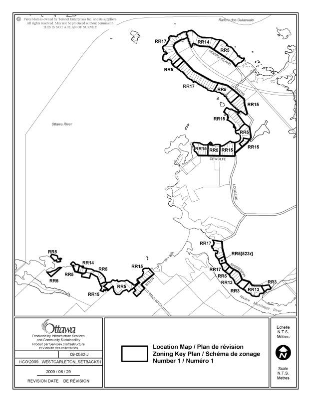
4. The zoning for the lands shown in Document 2 will be amended as follows:
Map 1
The RR3, RR5, RR13, RR14, RR15, RR17 zones shown on Map 1 will have the [343r] exception added to the zone code,
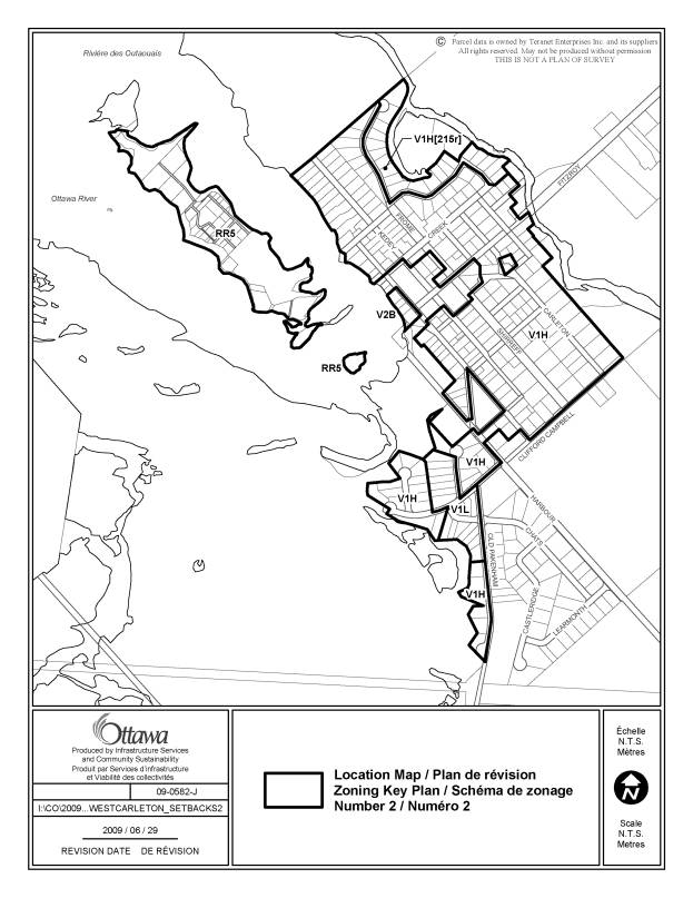
Map 2
The RR5, V1H, V1L, V2B zones shown on Map 2 will have the [343r] exception added to the zone code,
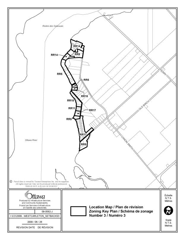
Map 3
The RR5, RR11, RR14, RR15, RR17 zones shown on Map 3 will have the [343r] exception added to the zone code,
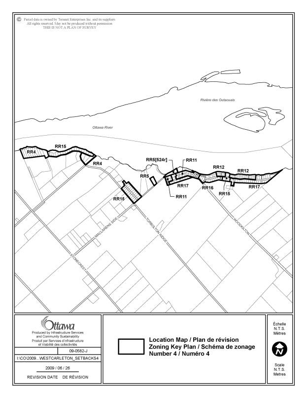
Map 4
The RR4, RR5, RR11, RR12, RR15, RR16, RR17 zones shown on Map 4 will have the [343r] exception added to the zone code,
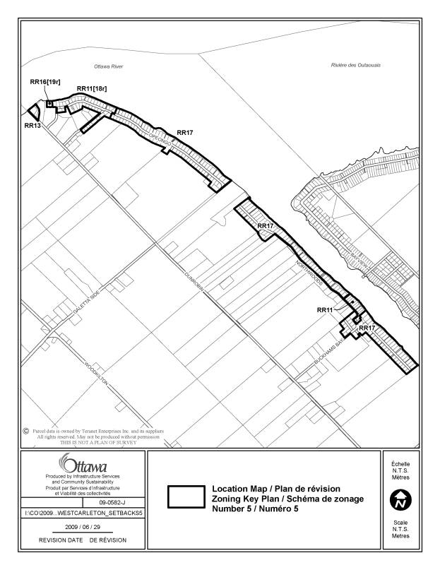
Map 5
The RR11, RR13, RR17 zones shown on Map 5 will have the [343r] exception added to the zone code,
The land zoned RR11[18r] will be rezoned to RR11[344r]
The land zoned RR16[19r] will be rezoned to RR16[345r]
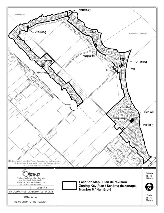
Map 6
The RI1 zone shown on Map 6 will have the [343r] exception added to the zone code,
The VM zone will have the [349r] exception added to the zone code,
The land zoned VM [166r] will be rezoned to VM[346r]
The land zoned V1H[594r] will be rezoned to V1H[350r]
The land zoned V1H[595r] will be rezoned to V1H[361r]
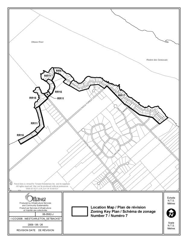
Map 7
The RR5, RR11, RR15, RR17 zones shown on Map 7 will have the [343r] exception added to the zone code,
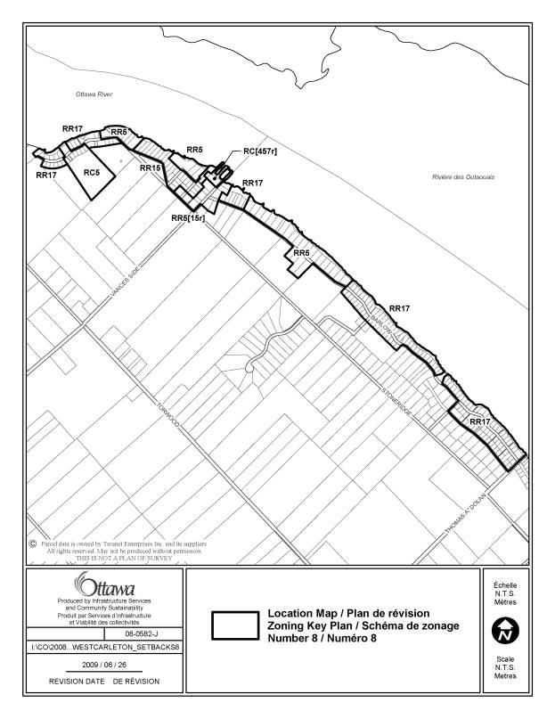
Map 8
The RR5, RR15, RR17, RC5 zones as shown on Map 8 will have the [343r] exception added to the zone code,
The land zoned RR5[15r] will be rezoned to RR5[347r],
The land zoned RC[457r] will be rezoned to RC[348r].
LOCATION MAPS DOCUMENT 2
CONSULTATION DETAILS DOCUMENT 3
NOTIFICATION AND CONSULTATION PROCESS
Notification and public consultation was undertaken in accordance with the Public Notification and Public Consultation Policy approved by City Council for Zoning By-law amendments.
PUBLIC COMMENTS
All comments regarding the proposed amendments that were received were positive, as the amendments will provide some flexibility for property owners who wish to construct additions, decks or accessory structures within the 30-metre setback. However, negative comments were received regarding the existing watercourse and waterbody provisions in Section 69. Residents indicated they felt these provisions are too restrictive. As it is necessary for the Zoning By-law to implement the policies in the Provincial Policy Statement and the Official Plan regarding setbacks from watercourses and waterbodies, staff do not contemplate amendments to further modify the existing provisions in response to these concerns.
Several comments were received from residents who suggested that Recommendations 2, 3 and 4 should also be applied to the area along the Ottawa River in former Kanata, or, to apply these amendments city-wide. For example, a resident who lives along the Ottawa River in former Kanata made the point that the former Kanata Zoning By-law 74 - 79 did not have a watercourse setback provision. As such, his situation is similar to that of property owners who were subject to the watercourse setback provisions in the former West Carleton Zoning By-law. Staff have considered these requests. In order to implement these amendments in other areas of the city, it would be necessary to provide additional notice to the public, as required by the Planning Act, indicating which areas of the city would be affected. Further analysis would be required to determine the areas where it would be appropriate to implement these amendments. Areas that are characterized by historic development on existing lots where it is difficult or impossible to achieve minimum setback distances because of the size or location of the lot or other physical constraints, and, where there were lenient or non-existent watercourse setback provisions would be targeted.
SUMMARY OF PUBLIC INPUT
Residents were in favour of the proposed amendments, however, they expressed frustration with the existing provisions in Section 69. Given that the Provincial Policy Statement and the Official Plan require that the setbacks from watercourses and waterbodies be implemented in order to protect water quality and to address hazards associated with steep slopes adjacent to waterbodies and watercourses, staff do not contemplate amendments to further modify the existing provisions in response to these concerns.
COUNCILLOR’S COMMENTS
The Councillors are aware of the proposed amendments and no comments in opposition have been received.
One Councillor inquired whether the amendments contemplated could be applied city-wide. As noted above, further notice under the Planning Act would be required and further analysis would be required to determine the areas where it would be appropriate to implement these amendments.
COMMUNITY ORGANIZATION COMMENTS
All community associations were notified and no comments in opposition were received.
ADVISORY COMMITTEE COMMENTS
The Environmental Advisory Committee and Ottawa Forest Advisory Committee were notified and no comments in opposition were received.
CONSERVATION AUTHORITY COMMENTS
The Conservation Authorities provided a joint response regarding the amendment to subsection (3) as these amendments would have a city-wide affect. In that response, they indicated that they had concerns with the existing form of Section 69, in that it allowed alternate setbacks to be contemplated for certain types of development. In their opinion, the proposed amendment to subsection (3) would be an improvement on the current wording of that subsection.
Regarding the proposed amendments in Recommendations 2, 3 and 4 that would affect the former West Carleton area, the Mississippi Valley Conservation Authority (MVCA) provided comments indicating they generally had no concerns with the proposed amendments. Regarding the proposed provision that would permit minor additions and accessory structures up to a maximum 24 metres square in floor area, they recommended that this should be a one-time only allowance for each property. City staff advise that the Village and Rural Residential zones affected by the proposed amendments contain maximum coverage provisions. As such, the total developable area is already limited through provisions in the Zoning By-law. Given the practical difficulties associated with monitoring the number of building permits associated with a property, and that lot coverage is already regulated by the Zoning By-law, staff have not implemented this suggestion. The MVCA had no objection to the reduction in the front yard setback to provide opportunities to locate buildings and structures on waterfront lots further away from the water. Regarding the proposed changes to allow projections, such as decks, within the 30-metre setback, the MVCA recommended that such projections should be permitted to extend no more than two metres from the principal building. Staff have implemented this suggestion in Recommendation 4.
Also discussed during consultations were practical issues relating to locating the normal high water mark. The Zoning By-law defines normal high water mark as, “the mark made by the action of water under natural conditions on the shore or bank of a watercourse or waterbody, the action having been so common or usual or so long continued that it has created a distinction in the general terrestrial vegetation, in changes in soil characteristics or by the edge of some embankment particularly scored by the action of water. It is a variable line in characteristic indicators and distinctiveness, and it is identified by the consideration of all visible evidence, not alone by one indicator, as located by an Ontario Land Surveyor.” Determining the location of the normal high water mark can be a complicated issue and can result in delays for property owners who wish to obtain approvals from the City. In order to streamline this process, staff have been in consultation with the Ontario Land Surveyors Association and the Conservation Authorities. Staff will be undertaking further discussions in an attempt to develop solutions associated with this issue.