|
2. REZONING - PART OF LOTS 3, 4 AND 5 CONCESSION I AND
PART OF LOTS 3 AND 5 CONCESSION II - GOULBOURN - PURDY ROAD AND DWYER HILL
ROAD, FROM THE EXISTING MINERAL AGGREGATE RESERVE (MR) AND (MR1) ZONES TO THE
RURAL COUNTRY SIDE (RU)ZONE. REZONAGE – PARTIE DES LOTS 3, 4 ET 5, CONCESSION I ET PARTIE DES LOTS 3
ET 5, CONCESSION II – GOULBOURN – CHEMIN PURDY ET CHEMIN DWYER HILL, DE ZONE
DE RÉSERVE DE GRANULAT MINÉRAL (MR) ET ZONE DE RÉSERVE DE GRANULAT MINÉRAL 1
(MR1) À ZONE D’ESPACE RURAL (RU) |
Committee RecommendationS
(This application is subject to Bill 51)
That Council approve:
1.
An amendment to the
Zoning By-law 2008-250 to change the zoning of properties on Purdy Road and
Dwyer Hill Road, being part of Lots 3, 4 and 5 Concession I, Goulbourn and part
of Lots 3 and 5 Concession II Goulbourn, from a combination of the Mineral
Aggregate Reserve (MR) and Mineral Aggregate Reserve 1 (MR1) Zones to the Rural
Countryside (RU) zone, as detailed in Document 2 and shown on Document 1.
2. That staff be directed to forward the by-law to implement Recommendation 1 to Council subject to the provisions of Section 24 of the Planning Act.
RecommandationS du Comité
(Cette
demande est assujettie au Reglement 51)
Que le Conseil approuve :
1.
une modification au Règlement de
zonage 2008-250, de manière à faire passer le zonage des propriétés des chemins
Purdy et Dwyer Hill faisant partie des lots 3, 4 et 5, concession I, Goulbourn
et des lots 3 et 5, concession II Goulbourn, de zone de réserve de granulat
minéral (MR) et zone de réserve de granulat minéral 1 (MR1) à
zone
d’espace rural (RU), tel qu’exposé en détail dans le Document 2 et
illustré dans le Document 1.
2.
que le personnel soit chargé de
transmettre au Conseil le règlement visé par la recommandation 1, sous réserve
des dispositions de l’article 24 de la Loi sur l’aménagement du territoire.
Documentation
1.
Deputy
City Manager's report Infrastructure Services and Community Sustainability
dated 4 September 2009 (ACS2009-ICS-PGM-0155).
Report
to/Rapport au :
Agriculture and Rural Affairs Committee
Comité d'agriculture et des questions rurales
and Council / et au Conseil
04 September 2009 / le 04 septembre 2009
Submitted
by/Soumis par : Nancy Schepers, Deputy City Manager /
Directrice municipale adjointe,
Infrastructure Services and Community
Sustainability/
Services d’infrastructure et Viabilité des
collectivités
Contact Person/Personne-ressource : Richard Kilstrom
Manager/Gestionnaire,
Policy Development and Urban Design
(613) 580-2424, 22653 Richard.Kilstrom@ottawa.ca
REPORT RECOMMENDATIONS
1.
That the
Agriculture and Rural Affairs Committee recommend Council approve an amendment
to the Zoning By-law 2008-250 to change the zoning of properties on Purdy Road
and Dwyer Hill Road, being part of Lots 3, 4 and 5 Concession I, Goulbourn and
part of Lots 3 and 5 Concession II Goulbourn, from a combination of the Mineral
Aggregate Reserve (MR) and Mineral Aggregate Reserve 1 (MR1) Zones to the Rural
Countryside (RU) zone, as detailed in Document 2 and shown on Document 1.
2. That staff be directed to forward the by-law to implement Recommendation 1 to Council subject to the provisions of Section 24 of the Planning Act.
RECOMMANDATIONS DU RAPPORT
1. Que
le Comité de recommande au Conseil d’approuver une modification au Règlement de zonage 2008-250, de manière
à faire passer le zonage des propriétés des chemins Purdy et Dwyer Hill faisant
partie des lots 3, 4 et 5, concession I, Goulbourn et des lots 3 et 5,
concession II Goulbourn, de zone de réserve de granulat minéral (MR) et zone de
réserve de granulat minéral 1 (MR1) à zone d’espace rural (RU),
tel qu’exposé en détail dans le Document 2 et illustré dans le Document 1.
2. Que le personnel soit
chargé de transmettre au Conseil le règlement visé par la recommandation 1,
sous réserve des dispositions de l’article 24 de la Loi sur l’aménagement du territoire.
BACKGROUND
This rezoning has been initiated by staff to be consistent with a change to the Official Plan already adopted by Council as part of the Official Plan Review. The change in the Official Plan removes the current Sand and Gravel Resource Area designation that applies to the land and replaces it with a General Rural Area designation. The zoning amendment recommended by this report will make the Zoning By-law consistent with the revised Official Plan.
The Official Plan amendment is with the Ministry of Municipal Affairs and Housing for approval and this zoning change is contingent upon that approval being granted.
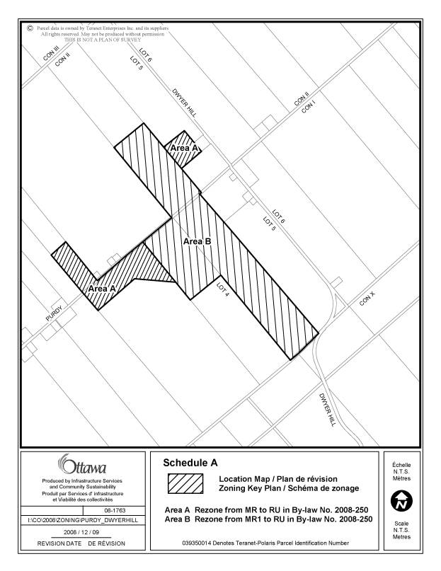
The land is located north and south of Purdy Road just to the west of the intersection of that road with Dwyer Hill Road in the former Goulbourn Township. The legal descriptions of the properties impacted are part of lots 3, 4 and 5 Concession I and Part of lots 3 and 5 Concession II Goulbourn, shown as areas A and B on the Location Map attached as Document 1. The general area contains farms, rural residential lots, idle land and closer to Dwyer Hill Road some former sand and gravel operations.
The City has identified the land for some time as part of a larger Sand and Gravel Resource Area. The Sand and Gravel Resource Area designation restricts development and use of properties on land containing aggregate resources but also limits the use of land within 300 metres of the designation. Mr Purdy, whose land on Purdy Road is impacted by these restrictions, made a submission supported by a technical assessment, to the recent Official Plan Review. The technical assessment was prepared by George Gorrell and showed that the quality and quantity of the aggregate deposits in a large part of the current resource designation is not viable for extraction and should not be part of the designation. Staff agreed with the findings of the consultant’s report, and that the current Sand and Gravel Resource Area designation should be reduced in size. Council adopted this change as part of Official Plan Amendment No.76 on June 24, 2009.
The Comprehensive Zoning By-law zones much of the same land as a Mineral Aggregate Reserve Zone. The reserve zones are intended to protect the land from development in anticipation of pit operations opening in the future. The zones not only limit development in the zone but also restrict uses on adjacent land.
Since much of the sand and gravel in this area is no longer considered to be commercially viable and in need of protection, staff are recommending the extension of the Rural Countryside (RU) zone to this land.
DISCUSSION
The subject land is placed into two Mineral Aggregate Reserve zones in the Comprehensive Zoning By-law. These zones restrict the development of the land and also prohibit dwellings and other sensitive land uses on adjacent lands, which limits development over a wide area. The removal of the Sand and Gravel Resource Area designation in the Official Plan acknowledges that this protection is no longer required in this area. The proposed change to the Zoning By-law will free up much of this land to be used for other purposes.
Proposed
Changes to the Comprehensive Zoning By-law
1. The proposed zoning amendment outlined in Document 2 will rezone:
- Part of Lot 3, Concession 2, Goulbourn, being Part of the West half of the East half of Lot 3; and
- Part of the East half of Lot 3, Concession 1 and Part of the West half of Lot 4, Concession 1, Goulbourn; and
§ Part of the East half of Lot 5, Concession 2, Goulbourn,
shown as Area A on the Location Map attached as Document 1, from the Mineral Aggregate Reserve (MR) zone to the Rural Countryside (RU) zone.
2. The proposed rezoning will also rezone:
§ Part of the North East half of Lot 4, Concession 1, Goulbourn;
§ the West half of Lot 5 Concession 1, Goulbourn; and
§ Part of the West half of Lot 5, Concession 2, Goulbourn,
shown as Area B on the Location Map attached as Document 1, from the Mineral Aggregate Reserve (MR1) Zone to the Rural Countryside (RU) zone. The MR1 Zone differs from the MR zone in that is also permits a dwelling.
The proposed Rural Countryside (RU) Zone that is recommended for these lands applies to the majority of the surrounding land. This zoning will permit a range of rural uses, including dwellings, to be constructed on the subject land.
ENVIRONMENTAL IMPLICATIONS
The lands included in the zoning change have not been identified as environmental lands although they abut land having potential to contain features classified as part of the City’s natural heritage system. The Official Plan requires the City to consider the impact of any proposed development on abutting features when development is proposed. This zoning does not propose any specific development.
RURAL IMPLICATIONS
There are no direct impacts on the rural area as a result of this zoning change. The land will be returned to a zoning consistent with and permitting the same land uses as the adjacent lands. Existing pit operations in the vicinity are protected from incompatible development by the remaining Sand and Gravel Resource Area designation and the separation distances required for those operations by the Official Plan and Zoning By-law.
CONSULTATION
Notice of this application was provided in accordance with the City's Public Notification and Consultation Policy. Details of the public and technical consultation are provided in Document 3.
The adjacent landowners were contacted and advised in advance of the proposed changes to the to the Official Plan and given advanced notice of this proposal to also change the zoning. The Ward Councillor is aware of and has no objections to the changes staff propose for these properties.
Staff of the Ministry of Natural Resources who are responsible for aggregate resource protection, were consulted on the changes to both the Official Plan and Zoning By-law and have not objected to either change.
The City did not receive any public or agency submissions in opposition to this zoning change.
LEGAL/RISK MANAGEMENT IMPLICATIONS
There are no legal/risk management issues associated with this report.
FINANCIAL IMPLICATIONS
APPLICATION PROCESS TIMELINE STATUS
This zoning change was initiated by the City and was not subject to the time lines established for the processing of applications for Zoning By-law amendment. This amendment was scheduled to follow a change to the Official Plan as part of five-year review. As a result, this zoning will not take effect until the Minister of Municipal Affairs and Housing has approved Official Plan Amendment No 76, which is anticipated to be received at the end of 2009.
SUPPORTING DOCUMENTATION
Document 1 Location Map
Document 2 Details of Recommended Zoning
Document 3 Consultation Details
DISPOSITION
City Clerk and Legal Services Branch, Legislative Services to notify the owners of the lands impacted by the change and Ghislain Lamarche, Program Manager, Assessment, Financial Services Branch (Mail Code: 26-76) of City Council’s decision.
Planning and Growth Management Department to prepare the implementing by-law, forward to Legal Services and undertake the statutory notification.
Legal Services to forward the implementing by-law to City Council.
LOCATION MAP DOCUMENT
1
![]()
DETAILS OF RECOMMENDED ZONING DOCUMENT
2
Proposed
Changes to the Comprehensive Zoning By-law
1. The proposed zoning amendment outlined in Document 2 will rezone:
- Part of Lot 3, Concession 2, Goulbourn, being Part of the West half of the East half of Lot 3; and
- Part of the East half of Lot 3, Concession 1 and Part of the West half of Lot 4, Concession 1, Goulbourn; and
§ Part of the East half of Lot 5, Concession 2, Goulbourn,
shown as Area A on the Location Map attached as Document 1, from the Mineral Aggregate Reserve (MR) zone to the Rural Countryside (RU) zone.
2. The proposed rezoning will also rezone:
§ Part of the North East half of Lot 4, Concession 1, Goulbourn;
§ the West half of Lot 5 Concession 1, Goulbourn; and
§ Part of the West half of Lot 5, Concession 2, Goulbourn,
shown as Area B on the Location Map attached as Document 1, from the Mineral Aggregate Reserve (MR1) Zone to the Rural Countryside (RU) zone.
CONSULTATION DETAILS DOCUMENT 3
NOTIFICATION AND CONSULTATION PROCESS
Notification and public consultation was undertaken in accordance with the Public Notification and Public Consultation Policy approved by City Council for Zoning By-law amendments. No public meetings specifically for this zoning change were held in the community. However, two rural public meetings associated with the Official Plan review, which included the removal of the Sand and Gravel Resource Area designation from these lands, were held. Questions concerning this zoning change were responded to at those meetings but no objections were voiced.
PUBLIC COMMENTS
Enquires and questions related to zoning were responded to by phone and at the Public Meetings held for the Official Plan. No objections were received.