|
8. ZONING - PART OF 5500 KANATA
AVENUE ZONAGE - PARTIE
DU 5500, AVENUE KANATA |
Committee recommendation
(This
application is subject to Bill 51)
That Council approve an amendment to the Zoning By-law 2008-250 to
change the zoning of Part of 5500 Kanata
Avenue from Residential Third Density Subzone V V, urban
exception 1037 (R3V V[1037]) to Residential Fourth Density Subzone M (R4M), and
to amend urban exception 744 as detailed in Document 2 and as shown in Document 1.
Recommandation DU Comité
(Cette demande est
assujettie au Règlement 51)
Que
le Conseil approuve une modification au Règlement de zonage no 2008-250
afin de changer le zonage d’une partie de la propriété située au 5500, avenue Kanata, de Zone
résidentielle de densité 3, Sous-zone V V, exception urbaine 1037 (R3V
V[1037]) à Zone résidentielle de densité 4, Sous-zone M (R4M), et de modifier
l’exception urbaine 744 comme l’explique le document 2 et l'illustre le document 1.
Documentation
1.
Deputy
City Manager’s report, Infrastructure Services and Community Sustainability
dated 4 August 2009 (ACS2009-ICS-PGM-00146).
Report to/Rapport au :
Planning
and Environment Committee
Comité de l'urbanisme et de l'environnement
and Council / et au Conseil
04 August 2009 / le 04 août 2009
Submitted by/Soumis par : Nancy Schepers, Deputy City Manager
Directrice municipale adjointe
Infrastructure Services and Community Sustainability
Services d’infrastructure et Viabilité des collectivités
Contact Person/Personne-ressource : Michael Wildman,
Manager/Gestionnaire, Development Review-Suburban Services/Examen des projets
d'aménagement-Services suburbains, Planning and Growth Management/Urbanisme et
Gestion de la croissance
(613) 580-2424, 27811 Mike.Wildman@ottawa.ca
|
SUBJECT: |
ZONING - Part of 5500 Kanata Avenue
(FILE NO. [D02-02-09-0032]) |
|
|
|
|
OBJET : |
REPORT RECOMMENDATION
That the recommend Council approve an
amendment to the Zoning By-law 2008-250 to change the zoning of Part of 5500 Kanata Avenue from Residential Third
Density Subzone V V, urban exception 1037 (R3V V[1037]) to Residential Fourth
Density Subzone M (R4M), and to amend urban exception 744 as detailed in
Document 2 and as shown in Document 1.
RECOMMANDATION DU
RAPPORT
Que le Comité de l’urbanisme et de
l’environnement recommande au Conseil d’approuver une modification au Règlement
de zonage no 2008-250 afin de changer le zonage d’une partie de
la propriété située au 5500, avenue
Kanata, de Zone
résidentielle de densité 3, Sous-zone V V, exception urbaine 1037 (R3V
V[1037]) à Zone résidentielle de densité 4, Sous-zone M (R4M), et de modifier
l’exception urbaine 744 comme l’explique le document 2 et l'illustre le document 1.
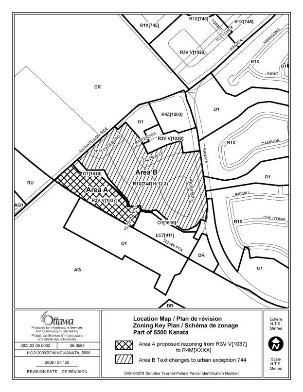
BACKGROUND
The subject site
is located at 5500 Kanata Avenue, which is bounded by Kanata Avenue, the proposed Terry Fox
Drive extension, and Richardson Side Road. The subject site is an irregular
parcel within a larger plan of subdivision that is 17.2 hectares in area. The
site is undeveloped and is characterized by steep, rocky topography and
extensive vegetation. Surrounding land uses includes the Heritage Hills
subdivision to the east, future urban development lands to the north and west,
and a stormwater management facility to the south. Part of the site (Area A as
shown on Document 1) is subject to the proposed rezoning and is 1.93 ha in
area. Area B as shown on Document 2 is subject to a text change to urban
exception 744.
Draft approval of a Plan of Subdivision for the
site occurred in March 2006 and was extended in March 2009, consisting of a mix
of residential dwelling types, a park, an open space corridor, and a commercial
block. Zoning By-law amendments for the
site were enacted by Council in October 2005 and March 2008, which reflected
the subdivision configuration.
Purpose
of Zoning Amendment
The proposed
zoning amendment is intended to permit the development of 120 stacked townhomes
in Block 153 of the subdivision, located along the future Terry Fox Drive
between Richardson Side Road and Tillsonburg Street. It is also required to
clarify the rear yard setbacks for lots that have both residential and open
space zoning.
The affected area is designated as General Urban Area in the Official Plan and is currently zoned for low to medium density residential (R3V V[1037], R1X[744] H(12.2) and open space (O1 and O1[1616]).
The current R3V V[1037] zoning permits a variety of housing types including
multiple attached dwellings (townhomes).
The proposed R4M zoning will permit low rise apartment buildings,
stacked townhomes, and a variety of other dwelling types. The intention of the
applicant is to build a planned unit development consisting of stacked
townhomes.
The rear yard setback measurement for all lots in the R1X [744] H(12.2) zone will also be clarified, which will specifically affect lots that back onto the O1 [1616] zone. This will ensure that rear yard setbacks will be measured from the boundary of the residential zone rather than the rear lot line, in order to protect the subject open space lands.
DISCUSSION
The site is
designated as General Urban Area on Schedule “B” of the Official Plan. This designation permits all types and
densities of residential development along with a range of other uses that are
compatible with the surrounding community.
The addition of a greater range of housing types for varying lifestyles
is encouraged.
According to Section 2.2.3 of the Official
Plan, the City supports intensification and infill throughout the urban area.
The Official Plan requires that developments providing infill and
intensification be compatible with their surroundings. This means that the new development must fit
well with, and respect the pre-established character of the existing
community. This can include building
form, setbacks, height, proportions, distance between buildings, and building
location.
Official Plan Section 4.7.7 indicates that the City will encourage the
protection of landform features in addition to those identified specifically in
the Official Plan, such as escarpments or rock outcrops. The Official Plan policies encourage owners
and developers to use selective grading to minimize topographic change, as well
as employ flexible setbacks to allow for creative building siting. The related Zoning By-law amendments will
allow for the protection of the landform features of the site by allowing flexibility
in height and setback, and protection of the steep slope.
In light of the above, the proposed Zoning By-law amendment conforms to
the applicable Official Plan policies.
The Council approved “translate the broad framework into detailed principles for development. These guidelines play an integral role in achieving high quality design throughout the city, and are A “greenfield neighbourhood” refers to a large area of land within the Urban Area that has not been developed previously, or that has the potential to be extensively redeveloped. These design guidelines are focused on providing guidance for neighbourhood design during the subdivision review and zoning processes. Among the principles of the design guidelines are the following:
·
Mix various
types of housing on each street while considering the relationship (height,
size, bulk) between each other, and to existing houses.
· Locate residential buildings close to the property line with their primary face addressing the street, and provide visual interest along the streetscape with a variety in setbacks and projections.
The proposed rezoning satisfies these criteria by offering a range of unit types and orienting buildings close to the street. The site will be subject to Site Plan Control Approval, at which time details of building layout, landscaping and grading will be addressed.
Site Grading
The applicant intends to retain as much of the unique natural topography of the site as possible. A steep slope exists along the southwest edge of the site. The proposed zoning of the open space lands will restrict the use of the sloped lands to private open space and conservation uses. In order to ensure that appropriate setbacks are provided from the open space lands, the minimum rear yard setback will be taken from the boundary of the lands zoned R1X [744] H(12.2).
Details of Changes to Zoning By-law 2008-250
The applicant is proposing to rezone Area A as shown on Document 1 from R3V V[1037] to R4M. The proposed R4M zoning will permit low-rise apartment buildings, stacked townhomes, and a variety of other dwelling types.
The applicant is also proposing to amend
urban special exception 744 as detailed in Document 2, to ensure that lands
zoned O1 [1616] are protected from development. The R1X [744] H(12.2) zone
currently requires a minimum rear yard setback of 6 metres. Due to the fact
that many of the properties zoned R1X [744] H(12.2) are dually zoned O1 [1616],
it is important to clarify in urban special exception 744 that the rear yard
setbacks will be taken from the boundary of the residential zone rather than
the rear property line.
Conclusion
The proposed permitted use is considered appropriate for the site, and
will achieve the goal of providing a full range and choice of housing types. Further, the location on a collector road is considered an
appropriate location for a higher density infill development, while respecting the existing character of the
community. The proposal makes use of existing services, and is supportive of
transit and pedestrian use. The Department supports
this Zoning By-law amendment because the proposed use is compatible with the
surrounding area and conforms to the applicable policies outlined within the
Official Plan.
The Department also supports the minor revision proposed to the R1X [744] H(12.2) zone, as it meets the intent of both the official plan and Zoning By-law 2008-250, as it will ensure the protection of the abutting open space lands.
CONSULTATION
Notice of this application was carried out in accordance with the City's Public Notification and Consultation Policy. The Ward Councillor is aware of this application and the staff recommendation. The City did not receive any negative comments or opposition to this application.
LEGAL/RISK MANAGEMENT IMPLICATIONS
There are no legal/risk management implications associated with this report.
FINANCIAL IMPLICATIONS
There are no direct financial implications associated with this report.
APPLICATION PROCESS TIMELINE STATUS
This application was processed by the "On Time Decision Date" established for the processing of Zoning By-law amendment applications.
SUPPORTING DOCUMENTATION
Document 1 Location Map
Document 2 Details of Recommended Zoning
DISPOSITION
City Clerk and Legal Services Branch, Legislative Services to notify the owner, Kanata Road Inc., c/o The Regional Group, 1737 Woodward Drive, Ottawa, ON. K2C 0P9 applicant, The Regional Group, attn: Josh Kardish, 1737 Woodward Drive, Ottawa, ON. K2C 0P9, OttawaScene.com, 174 Colonnade Road, Unit #33, Ottawa, ON K2E 7J5, Ghislain Lamarche, Program Manager, Assessment, Financial Services Branch (Mail Code: 26-76) of City Council’s decision.
Planning and Growth Management to prepare the implementing by-law, forward to Legal Services and undertake the statutory notification.
Legal Services to forward the implementing by-law to City Council.
LOCATION
MAP DOCUMENT 1
DETAILS OF RECOMMENDED ZONING DOCUMENT
2
Proposed Changes to the Comprehensive Zoning By-law
1. The lands shown as Area A on Document 1 zoned R3V V[1037] in Zoning By-law 2008-250 are rezoned R4M.
2. The land shown as Area B (Section 239, urban exception 744) will be subject to a text, Column V will be amended to include the following provision:
(a) The minimum rear yard setback to building main shall be measured from the R1X [744] H(12.2) zoning boundary when abutting lands zoned O1 [1616].
(b) Notwithstanding Table 55, the setbacks required for an accessory structure or building shall be measured from the R1X [744] H(12.2) zoning boundary when abutting lands zoned O1 [1616].