|
13. COMPREHENSIVE ZONING BY-LAW
2008-250: ANOMALIES AND MINOR CORRECTIONS - EIGHTH REPORT RÈGLEMENT DE ZONAGE GÉNÉRAL NO
2008-250 : ANOMALIES ET CORRECTIONS MINEURES - HUITIÈME RAPPORT |
(This matter is subject to Bill 51)
Planning and environment Committee
recommendation as amended
That Council approve the amendments recommended in Column 3 of
Document 1, to correct anomalies in Zoning By-law 2008-250, as amended in
items 16 and 28, and by adding item 29.
That there be no further notice pursuant to Section 34 (17)
of the Planning Act.
Agriculture
and Rural Affairs Committee recommendation
That Council approve the
amendments recommended in Column 3 of Document 2, to correct anomalies in
Zoning By-law 2008-250.
(Cette question
est assujettie au Règlement 51)
Recommandation MODIFIÉE DU Comité de l’urbanisme et de l’environnement
Que le Comité de l’urbanisme et de l’environnement recommande au Conseil
d’approuver les modifications recommandées dans la Colonne 3 du document 1 afin
de corriger des anomalies dans le Règlement de zonage 2008-250 au moyen des
modifications contenues aux points 16 et 28 et par l’ajout du point 29.
Qu’aucun autre avis ne soit donné,
conformément au paragraphe 34 (17) de la Loi sur l’aménagement du territoire.
Recommandation DU ComitÉ
de l’agriculture et des questions rurales
Que le Conseil approuve les modifications recommandées dans la Colonne 4
du Document 2 afin de corriger des anomalies dans le Règlement de zonage
2008-250.
Documentation
1.
Deputy
City Manager's report Infrastructure Services and Community Sustainability
dated 31 July 2009 (ACS2009-ICS-PGM-0153).
2.
Planning
and Environment Committee, Extract of Draft Minutes 58, dated 25 August 2009.
Report to/Rapport au :
Planning and Environment Committee
Comité de l'urbanisme et de l'environnement
and /
et
Agriculture
and Rural Affairs Committee
Comité de l'agriculture et des questions rurales
and Council / et au Conseil
31 July 2009 / le 31 juillet 2009
Submitted
by/Soumis par : Nancy Schepers, Deputy City Manager
Directrice municipale adjointe,
Infrastructure Services and Community
Sustainability
Services d’infrastructure et
Viabilité des collectivités
Contact Person/Personne-ressource :
Richard Kilstrom, Manager/Gestionnaire, Policy Development and Urban
Design/Élaboration de la politique et conception urbaine, Planning and Growth
Management/Urbanisme et Gestion de la croissance Élaboration de la politique et
conception urbaine
(613)
580-2424 x22653, Richard.Kilstrom@ottawa.ca
SUBJECT:
|
COMPREHENSIVE ZONING BY-LAW 2008-250:
ANOMALIES AND MINOR CORRECTIONS - eightH REPORT |
|
|
|
OBJET :
|
RÈGLEMENT
DE ZONAGE général no 2008-250 : ANOMALIES ET CORRECTIONS
MINEURES – huitIÈME RAPPORT |
REPORT
RECOMMENDATIONS
1. That Planning and Environment Committee recommend that
Council approve the amendments recommended in Column 3 of Document 1, to
correct anomalies in Zoning By-law 2008-250; and
2. That Agriculture and Rural Affairs Committee recommend that
Council approve the amendments recommended in Column 3 of Document 2, to
correct anomalies in Zoning By-law 2008-250.
RECOMMANDATIONS DU RAPPORT
1.
Que le Comité de l’urbanisme et de
l’environnement recommande au Conseil d’approuver les modifications
recommandées dans la colonne 3 du document 1 afin de corriger des anomalies
dans le Règlement de zonage no
2008-250;
2.
Que le Comité de l’agriculture et
des affaires rurales recommande au Conseil d’approuver les modifications
recommandées dans la colonne 3 du document 2 afin de corriger des anomalies
dans le Règlement de zonage no 2008-250.
BACKGROUND
On June 25, 2008 City Council adopted the new Comprehensive Zoning By-law 2008-250, which affects all properties within Ottawa. By-law 2008-250 replaces the 36 Zoning By-laws of the former municipalities that were amalgamated in 2001. Since the adoption of the Zoning By-law, staff has been identifying anomalies that require correction, and reports to correct the anomalies are being forwarded to Committee and Council on a regular basis. This report details recommended amendments to correct a number of the identified anomalies.
DISCUSSION
Documents 1 and 2 provide staff recommendations to Planning and Environment Committee and Agriculture and Rural Affairs Committee on the identified anomalies, and include details of the recommended amendments in the urban area in Column 3 of Document 1, and amendments to the rural or greenbelt areas in Column 3 of Document 2. Document 3 contains the maps showing the location of zoning map corrections.
The amendments are intended to correct mapping and text reference errors in the implementation of Council-approved changes that were not accurately reflected in the Comprehensive Zoning By-law.
CONSULTATION
Notice of the public meeting to deal with these anomalies and corrections was provided in The Citizen and Le Droit, with a listing of the addresses and provisions subject to correction. As well, interested parties have been notified by individual mail.
LEGAL/RISK MANAGEMENT IMPLICATIONS
The changes addressed this report are items of a routine nature. There are no Legal/Risk Management implications.
FINANCIAL IMPLICATIONS
There are no direct
financial implications associated with this report.
SUPPORTING DOCUMENTATION
Document 1 List
of Anomalies and Modifications to Zoning By-law 2008-250 for consideration by
Planning and Environment Committee (amended)
Document 2 List of Anomalies and Modifications to Zoning By-law 2008-250 for consideration by Agriculture and Rural Affairs Committee
Document 3 Location
Maps
DISPOSITION
Planning and Growth Management Department to prepare the implementing by-law and forward it to Legal Services who will then forward the by-law to City Council.
LIST
OF ANOMALIES AND MODIFICATIONS TO ZONING
BY-LAW
2008-250 FOR CONSIDERATION BY PLANNING
AND ENVIRONMENT COMMITTEE AMENDED DOCUMENT 1
|
Item No. |
Objective of Amendment |
Proposed Amendment |
|
1. Grenwich Circle and Whitestone Drive Ward 16 |
Clarification is required to confirm
whether the 6.0 metre setback requirement applies for all rear yard setbacks
within the subzone, or, if the 6.0 metre setback applies to only those rear
yards that abut an EP zone. |
Amend Column V of Exception [515] by
deleting the words, “-minimum setback of 6 m from EP zone and the rear lot line”. Amend Column V of Exception [515] by adding the words, “-minimum required setback of 6 m from
any lot line abutting an EP zone -minimum required rear yard setback is 6
m”. |
|
2. 79 Whitestone Drive Ward 16 |
The zoning boudary between the R1S [515]
and R2U [553] subzones should be amended so that it follows a property line,
rather than being located through the middle of the lot located at 79
Whitestone Drive. |
Rezone part of 79 Whitestone Drive from
R1S [515] to R2U [553]. This will
result in the zoning boundary being located along the property line between
81 Whitestone Drive and 79 Whitestone Drive as shown in Document 3. |
|
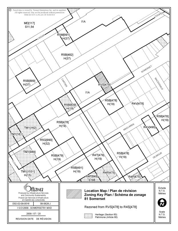
3. 81 Somerset
Street Ward 14 |
Typographical error on zoning maps. RVS[478] should be R4S[478]. |
Amend the zoning map to indicate the
subject lands as R4S[478] instead of RVS[478] as shown in Document 3. |
|
4. Section 9 - Transition Citywide |
Amend the Transition provisions to specify
that they are applicable only to completed applications submitted on or after
the date of the release of the first
draft of the new Comprehensive Zoning By-law on May 26, 2006. The purpose of
this provision was solely to allow for a reasonable transition period for
applications submitted at the time the new by-law was undergoing the formal
public review process; it was not intended to give relief from the by-law to
applications submitted well before the new by-law process began. |
Amend Section 9(1)
to change the words “was received by June 25, 2008” to state “was received on
or after May 26, 2006 and on or prior to June 25, 2008” . |
|
5. 555 and 591 March Road Ward 4 |
The IP6[1084] H(12) and IP6[1149] H(12) zones on these
lands permit all the commercial uses allowed in the former Kanata By-law
132-93, which was amended on a site specific basis with by-law 2006-384, to a
C1S(3) and C1S(4) zoning respectively, except for gar bar in the former
C1S(3) zone. This should be added. As well, the section reference in the
provisions is incorrect and should be revised. |
Amend Column III of exception [1084] to add “gas bar”. Amend Column V of exceptions [1084] and [1149] to refer to Section 205 (2) (b) and (c) instead of 199 (2) (b) and (c) |
|
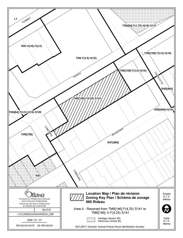
6. 560 Rideau Street Ward 12 |
The TM6 [146] F(4.25) S141 zone should
include an “h” holding symbol to reflect the Ontario Municipal Board decision
requring site plan control approval prior to enacting the zoning. |
Amend the zoning map by rezoning the subject lands from TM6
[146] F(4.25) S141 to TM6 [146]-h F(4.25) S141 as shown in
Document 3. Amend Exception 146, Column II to delete “TM6 [146] F(4.25) S141” and add “TM6 [146]-h F(4.25) S(141) Amend Exception 146, Column V to add the following provision: - the “h” symbol will not be removed
until site plan control approval has been granted by the City of Ottawa. |
|
7. Parking requirement for bed and
breakfast Former Ottawa and Vanier |
The parking requirement for bed and
breakfast for Areas A and B on
Schedule 1 (former Ottawa and Vanier) is shown as 1 per dwelling unit plus 1
per guest room for the first 4 guest rooms.
This should be revised to the same requirement of the former Ottawa
Zoning By-law of 1 per dwelling unit and 1 for the first 4 guest rooms. |
Amend Section 101, Table 101 c) Columns II and III, (Areas A and B) by deleting the
existing text and replacing it with the following: 1 per dwelling unit plus 1 for the first
four guest rooms plus 0.45 for each additional guest room over 4 |
|
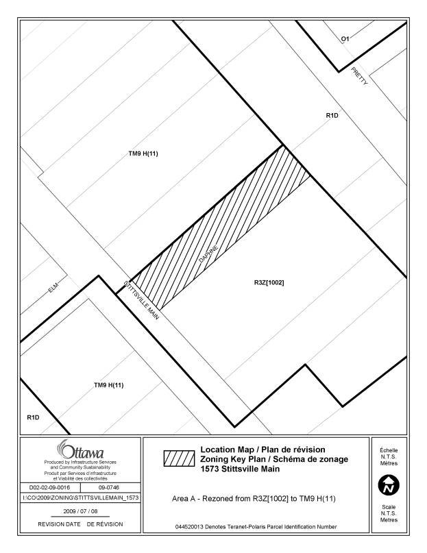
8. 1573 Stittsville Mainstreet Ward 6 |
A 2000 site specific rezoning to R4-7 of
the adjacent property incorrectly included 1573 Stittsville Mainstreet in former Goulbourn Zoning
By-law. This residential zoning was carried forward
into the new zoning by-law. The
subject lands should be rezoned TM9 H(11) - Traditional Mainstreet as per the adjoining properties to the
north. |
Amend the zoning map to rezone the
subject lands from R3Z [1002] to TM9 H(11) as shown on Document 3. |
|
9. 100 Castlefrank 1023 Teron 35 Beaufort 710, 788, 807 March 701, 801, 907 Eagleson 60 Stonehaven 60 Sweetnam 7, 99 Kakulu 2 Goldridge 5500 Kanata 200 Katamavik Northeast Corner of Goulbourn Forced Road
and Kanata Avenue Part of
425Goulbourn Forced Wards 4 and 23 |
The LC7 – Local Commercial zone does not
permit convenience stores. As the former Kanata Zoning By-laws permitted
retail stores on these LC7 sites and did not identify convenience store as a
distinct use, convenience store should be added to the LC7 subzone as a
permitted use. Certain LC7 subzones that only permitted a limited number of uses
that excluded retail store would also exclude convenience store. Exception
220 will need to add convenience store to the list of uses that must not exceed a total of 1400 m2 .
For Exception 1523, convenience store
needs to be added to uses that are not prohibited. For Exceptions 1519 and 1524, convenience
store can be deleted as an additional permitted use. Exception 227 in Column V refers to a community centre,
which is not a permitted use in LC7.
Column III needs to be amended to add community centre as an
additional permitted use. |
Amend Section 190(7), the LC7
subzone, to add “convenience store”
as a permitted use; Amend Exception 220, Column V to add the
words “convenience store” between “ -
the total gross leasable floor area for a personal service business,
restaurant full service, restaurant takeout, …” and “… retail food store and retail store must not exceed a
total of 1400 m2;” |
|
10. 806, 812, 830, 846 March Ward 4 |
Exceptions 1522 and 1527 have been made
redundant by a 2009 rezoning. |
Delete all the text in Exceptions 1522
and 1527 so that they may be reserved for future use. |
|
11. 804, 806, 810 Greenbank ; 10, 16 Green Street Ward 3 |
Exception 1419 includes a provision
stating: “- the affected lands are considered as
one lot for zoning purposes”. This
provision was not in the former Nepean Zoning By-law and is not necessary. |
Amend
Column V of Exception 1419 to delete the provision: “ - the affected lands are considered as
one lot for zoning purposes”. |
|
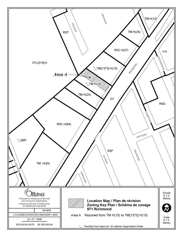
12. 971 Richmond Road Ward 15 |
Exception 1373 includes “automobile
dealership” as an additional permitted use for 955 and 965 Richmond Road. The
former Ottawa Zoning By-law also
included this additional permitted use
for 971 Richmond Road as the three addresses comprise one automobile
dealership. The zoning map should be amended to add Exception 1373 to 971
Richmond Road. In addition, the Ontario Municipal Board
recently approved the unappealed portions of the Richmond
Road/Westboro CDP Zoning By-law Amendment.
The zoning of the property is
now TM H(15). |
Amend the zoning map to rezone the subject lands from TM H(15) to TM [1373] H(15) as shown in
Document 3. |
|
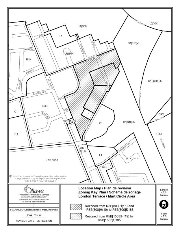
13. London Terrace/Mart Circle Area Ward 13 |
The schedule number does not appear on
the zoning map for the London Terrace/Mart Circle area covered by Schedule
185. Schedule 185 should be added to
each of the affected zoning codes. Maximum building heights are included in
Schedule 185 and thus do not need to appear on the zoning map. |
Amend the zoning map by rezoning the subject
lands from: -
R5B [800] H(11) and R5B[800] H(19) to R5B [800] S185; -
R5B [1553] H(19) to R5B [1553] S185 as shown in Document 3. |
|
14. 55 Laurier Avenue East Ward 12 |
The University of Ottawa had a shared
parking provision that applied to the subject lands under the former Ottawa
Zoning By-law. That provision should
be carried forward by adding it to Exception 111. |
Amend Column V of Exception 111 to add
the following provision: “- all required parking spaces, for a
post-secondary institution, may be located in any part of the I2A[347]
F(3.0), I2E[1377] F(3.0), I2E [1376] S232, I2A [1378] S232, MD[111] S67 and
LC2 zoned lots located within the University of Ottawa.” |
|
15. Exception 1532 |
Exception 1532 in Column II refers to two
zones: IL2 [1532]H(14)-h and IL4 [1532] H(14)-h. It should only apply to the IL2 [1532] zone H(14)-h zone. |
Amend Exception 1532 Column II to
delete “IL4 [1532] H(14)-h”. |
|
16. 720
Silver Seven Road Exception 1612 Ward 23 |
The provisions of Exception 1612 need to
be amended as they do not fully capture the intent on of the applicable
former Kanata Zoning By-law with regard to the definition of a retail store,
actual minimum width of landscaped buffer and restrictions on permitted uses
before the “h” symbol is removed by City Council. |
Amend Exception 1612 as follows: Column III - add “without any limitations on the types of products offered for sale” after “ - retail store”; Column V
“ - minimum width of landscaped buffer between a parking lot and lot line abutting the lot line that coincides with the boundary between Lots 1 and 2, Concession 2 of the Geographic Township of March: 4.5 m”;
... |
|
17. General Parking Provisions –
handicaped access Section 100 (7) Citywide |
Provide clarification to confirm that if
a parking space is eliminated as a result of providing handicap access to an
existing building, the use for which the parking is provided is to be treated
as though it meets the parking requirements of the by-law. |
Amend Section 100 by adding, the following provisions as subsection 10, “Where one parking, queuing or loading space required by this by-law or a predecessor to this by-law is eliminated as result of providing barrier-free access to a building existing as of June 25, 2008, the use for which the parking, queuing or loading space is provided is to be treated as though it meets the requirements of this by-law or a predecessor to this by-law immediately prior to the elimination of the parking, queuing or loading space.” Amend Section 100 by
adding the following provision as subsection 11, "Despite subsection
100(10), a parking space may only be eliminated to enable barrier-free access
to a use within a building where at least one parking space continues to be
provided for that use." Amend Section 100
(7) by adding the words, “or predecessor by-law”, following the words, “Despite subsection (1), where a motor vehicle parking space
required by this By-law”. Amend Section 60 (5) (c) by adding, “except for the exemption provided in Section 100 (7) and Section 100 (10)”, after the words, “Nothing in this subsection applies so as to permit the elimination of a parking space required on the day prior to the enactment of this by-law”. |
|
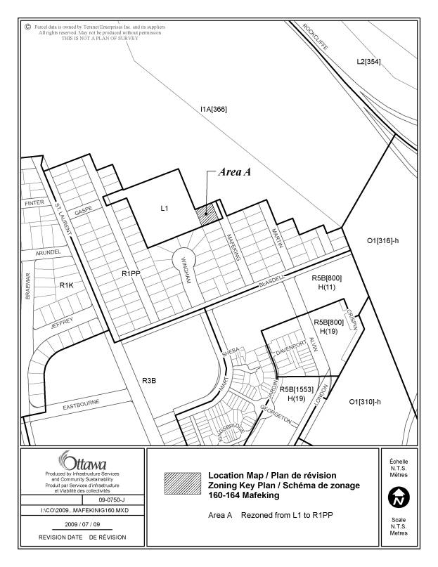
18.
160 and 164 Mafeking Avenue Ward 13 |
These lots, which contain detached
dwellings and were zoned residential under the former City of Ottawa Zoning
By-law, are located in an L1-Community Leisure Facility Zone. They should
instead be zoned R1PP as is the surrounding residential area. |
Rezone 160 and 164 Mafeking Avenue from L1 to R1PP, as shown in Document 3. |
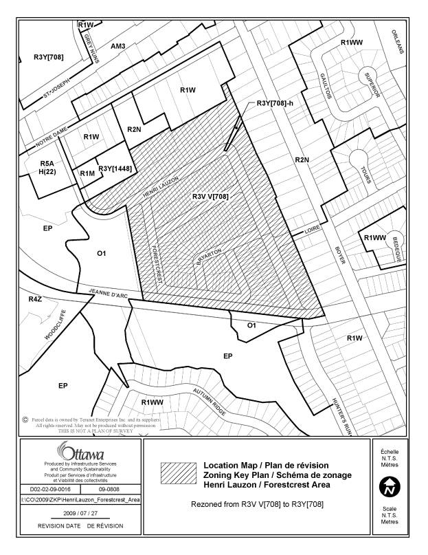
|
19. Henri Lauzon/ Forestcrest Area Ward
2 |
This area is shown on the zoning map as
R3VV [708], but as R3Y [708] in the Exceptions table. R3VV and R3Y have similar provisions, the
major difference being a minimum 3 metre front yard setback for townhouses in
the R3VV zone and a minimum 5 metre setback in the R3Y zone. As the former Gloucester Zoning By-law had
a minimum front yard setback of 5 metre and all the townhouses built in the
area have a minimum 5 metre setback, the zoning map should be amended from R3VV [708] to R3Y [708]. |
Amend the zoning map to rezone the subject lands from RVV [708] to R3Y [708] as shown on Document 3. |
|
20. Temporary Uses, Buildings Or
Structures During Construction - Section 71 Citywide |
Clarify that Section 71 is also intended
to apply to special events. |
Amend the title of Section 71 by adding, “Or Special Events”, following the words, “Temporary Uses, Buildings Or Structures During Construction”. Amend Section 71 (1) by adding, “or special events”, following the words, “Despite any provision to the contrary, the following temporary buildings, structures or equipment are permitted in any zone, except an EP zone, during a period of construction”. Amend Section 71 (1) (a) by adding, “or special event”, after the words, “the use of land or the use or erection of a temporary building, structure or equipment essential to the construction”. |
|
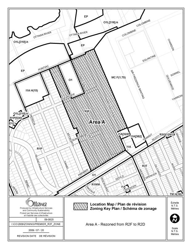
21. Area generally bounded by Premier
Avenue on the south, Northwestern Avenue on the east, Pontiac Street on the
north and Cowley Avenue on the west. Ward 15 |
As a result of a mapping error the zoning
standards for Area B, as shown in Schedule 1 of the former Ottawa Zoning
By-law, were applied to this R2F subzone.
This area was actually located in Area A, as shown in Schedule 1 of
the former Ottawa Zoning By-law, and the zoning standards for that Area
should be have been carried through in the new zoning. |
Amend the zoning map by rezoning the subject lands from R2F to R2D as shown on Document 3. |
|
22. Table 55 (7) – Accessory Uses,
Buildings and Structures Citywide |
The term “floor area” should be substituted for “gross floor
area” in this provision, regarding maximum size of an accessory
building. By definition, “gross floor
area” excludes common storage areas that are accessory to the principal use
of the building, bicycle parking and
motor vehicle parking. The more
general term, “floor area”, will permit the intent of this provision to be
properly implemented. |
Amend Column II of Table 55 (7) by adding the words, “as measured from the exterior walls of the building”, after the words, “Aggregate of all accessory buildings not to exceed a lot coverage of 50% of the yard in which they are located, with a maximum cumulative gross floor area of 55 m2”. Amend Column II of Table 55 (7) by
deleting the word “gross” from the phrase, “Aggregate of all accessory
buildings not to exceed a lot coverage of 50% of the yard in which they are
located, with a maximum cumulative gross floor area of 55 m2”. |
|
23. Section 239 – Urban Exceptions and
Section 240 – Rural Exceptions Citywide |
The use of the term “mulitple use” in
Column II – Applicable Zone of Table 239 and Table 240 has caused some
confusion regarding its interpretation.
In order to clarify the intent, the word “use” should be deleted from
the term “multiple use” from Column II in both tables. |
Amend Column II of Section 239 and Column II of Section 240 by deleting the word “use” wherever the term “multiple use” appears. Amend the introductions to Table 239 and Table 240 by deleting the word “use” from the following sentence, “The term “multiple use” utilized in Column II below indicates an exception that has been applied to several locations.”. |
|
24.
Clyde/Scout/Coleridge Area Ward 16 |
The R2T and R2U
zones do not have a minimum interior side yard setback other than abutting a
lane or a public pathway. The 0.3
metre minimum interior side yard setback of the former Ottawa Zoning By-law
R2G zone should be included in the R2T and R2U zone provisions. |
Amend the R2 -
Residential Second Density Zone, Section 158, Table 158B Additional Zoning
Provisions, Endnote 9, to add the words “0.3 m and” between “Minimum interior side yard
setback is…” and “…1.2 m for any yard abutting a public pathway or public
lane.” |
|
25. Table 102 - Visitor Parking Rates – apartment buildings over 300 units Central Area and Inner City |
The current visitor parking rates do not fully reflect those from former Ottawa, which were significantly lower for large apartment buildings (over 300 dwelling units) in downtown and inner city areas. Table 102 should be amended to include this reduction. |
1. Amend row (a) Apartment building, Mid-High Rise; Low Rise as follows: (a) by replacing the heading “For the balance of the dwelling units” in row (a)(ii), Column I, with the heading “For the next 300 dwelling units”. (b) by adding a new row (a)(iii) which states: (i) in Column I the heading “For the balance of the dwelling units”, (ii) in Columns II and III, the word “none” and (iii) in Columns IV and V the words “0.2 per dwelling unit” |
|
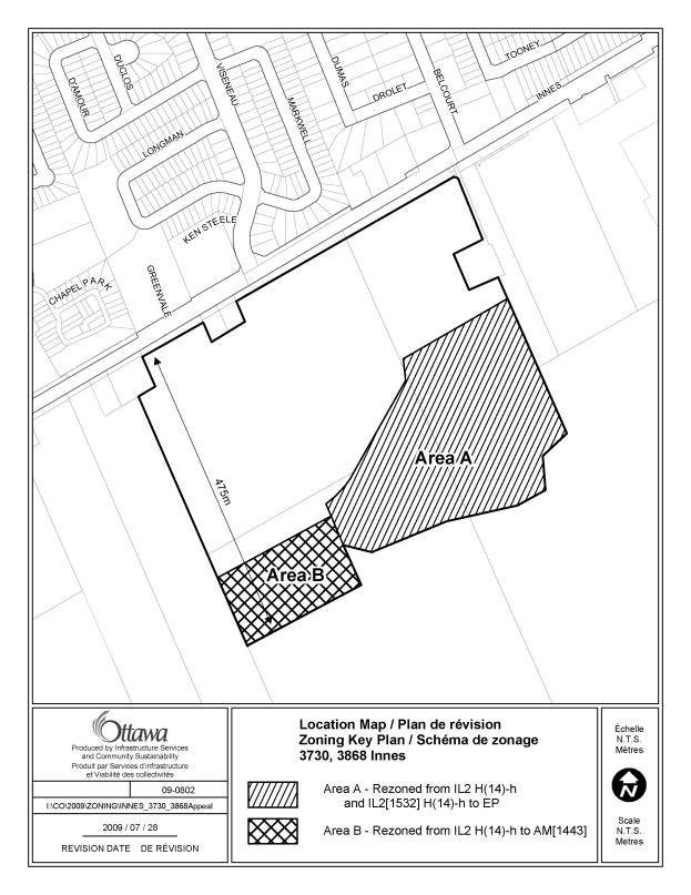
26. 3730 and 3868
Innes Ward 2 |
In 2007, Council
adopted an Official Plan Amendment which resolved an appeal of the Official
Plan Amendment 28, and which reflected a land exchange with the developer,
wherein Urban Natural Feature #87 – Innes Park Woods, would be transferred to
the City in exchange for other lands that would be redesignated Arterial
Mainstreet. As part of the agreement,
the affected lands were redesignated from Employment Area to Arterial
Mainstreet and 3730 Innes Road was to extend to a depth no greater than 475 m
back from the front property line fronting on Innes Road, excluding the Urban
Natural Features Area woodlot. The Zoning By-law
does not reflect the redesignations with the appropriate zoning. The lands fronting onto Innes Road and
zoned AM [1443] must be extended 475 metres back from Innes Road – currently
the depth does not extend that far back; and the area of the city-owned
woodlot (Parts 1 and 2 RP 4R-22628) should be rezoned to EP. |
Amend the Zoning Map
to rezone 3730 Innes Road from IL2 H(14)-h to AM [1443], so that the depth of
the area zoned AM [1443] extends no more than 475 m back from the front
property line, excluding the Innes Park Woods; and rezone the lands, known as
Part of Lots 2 & 3, Concession 3 (Ottawa Front), Parts 1 and 2 of Plan
4R-22628, zoned IL2 H(14)-h and IL 2[1532] H(14)-h to EP as shown on Document
3 . |
|
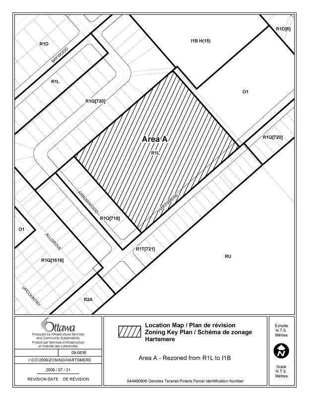
27. Hartsmere Drive
near the intersection of Arrowwood Drive Ward 6 |
The property in
question is vacant but is owned by the Ottawa-Carleton District School Board and
is intended for school development (2010-2011). However, it was erroneously
zoned R1L as the future plans for the site were unknown when the zoning was
applied. Consequently, it should be rezoned from R1L-
Residential First Density to
I1B- Minor Institutional. |
Rezone the subject lands
from R1L to I1B, as shown in Document 3. |
|
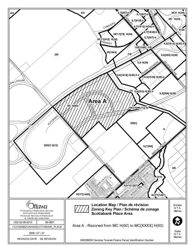
28. Scotiabank Place Area Ward 6 |
Former Kanata Zoning
By-law 125-90 allowed parking in the Scotiabank Place area to be provided on
different lots than the Scotiabank Place building. As the new Zoning By-law
does not include this provision, an exception is needed for the subject lands to recognize the
former by-law parking provisions. |
Amend the zoning map
to rezone the subject lands from MC H(60) to MC [xxxx] H(60) as shown on
Document 3. Add a new exception
to Section 239 that specifies the following provision: “The required
parking spaces for any use may be provided in a location other than the lot
on which the use is located and two or more users may share joint parking
facilities provided that the required parking spaces for any particular use
are not located more than 150 metres from the lot on which the use is
located. Notwithstanding the
aforementioned, parking spaces serving the uses within an entertainment
complex may be located up to 550 metres from the lot on which the use
is located.” |
|
29. South
side of Clarence Street to the south side of George Street, between William
Street and Dalhousie Street Ward 12 |
There is a typographical error on
the zoning map for the MD3 S73 subzone.
This area should have been zoned MD2 S73. |
Amend
the zoning map by rezoning the subject lands from MD3
S73 to MD2 S73 as shown in Document 3. |
That there be no further notice
pursuant to Section 34 (17) of the Planning Act.
LIST
OF ANOMALIES AND MODIFICATIONS
TO
ZONING BY-LAW 2008-250 FOR CONSIDERATION
BY AGRICULTURAL AND RURAL AFFAIRS COMMITTEE DOCUMENT 2
|
Item No |
Objective of Amendment |
Proposed Amendment |
|
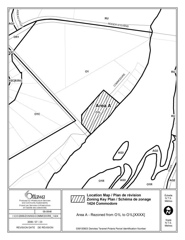
1. 1424 Commodore Lane Ward 21 |
||
|
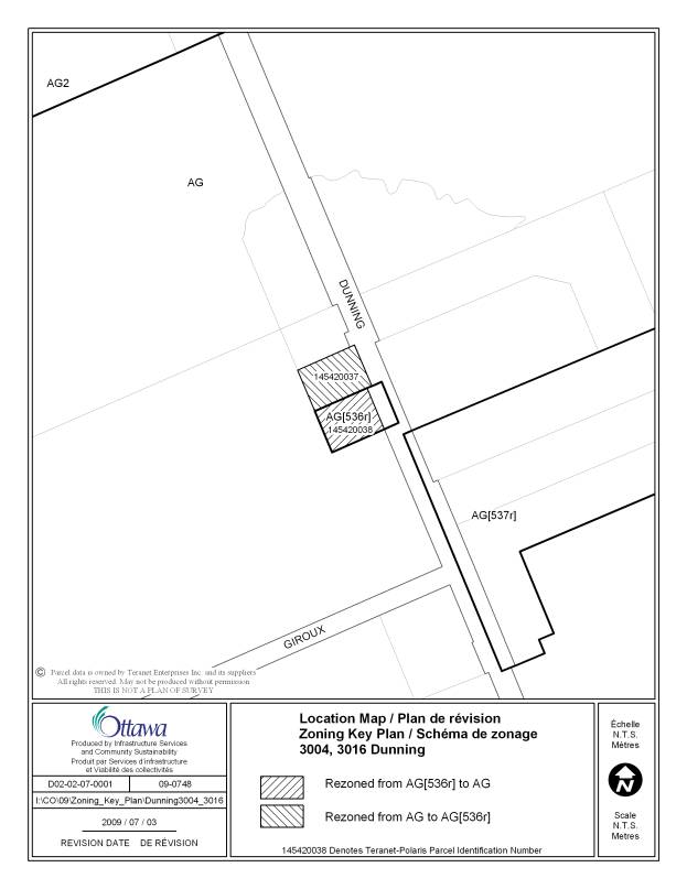
2. 3004 and 3016 Dunning Road Ward 19 |
The AG [536r], which allows a retail store limited to a butcher shop
(and was identified by exception in the former Cumberland zoning
by-law), has been incorrectly placed
on 3016 Dunning instead of 3004 Dunning, locate immmediately to the north,
which actually has the butcher shop.
Exception 536r should be transferred from 3016 Dunning to 3004
Dunning. The automobile service station operating
out of 3016 Dunning is a non-permitted use in the AG zone. It was not permitted in the former
Cumberland Zoning By-law and is not a farm-related commercial or industrial
use. No change to the non-permitted status of the automobile service station
is proposed. |
Amend the zoning map to rezone 3004 Dunning from AG to AG [536r] and 3016 Dunning from AG [536r]
to AG as shown on Document 3. |
|
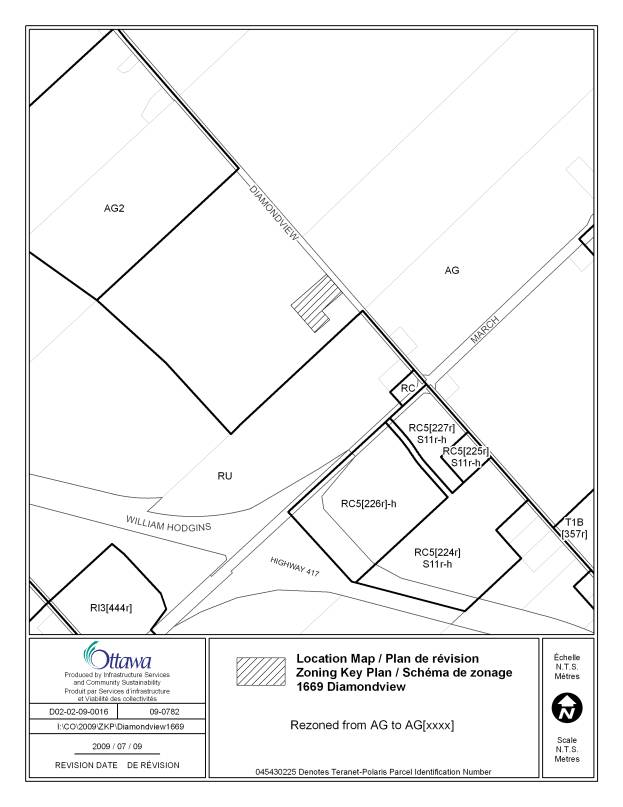
3. 1669 Diamondview Road Ward 5 |
The former West Carleton Zoning By-law
contained a site-specific zoning that permitted the existing use of the
property – storage, maintenance and repair of aircraft. As the current AG zoning does not permit
this use, a site-specific exception will be required to recognize the
existing use. |
Amend the zoning map to rezone 1669
Diamondview Road from AG to AG[xxxx] as shown on Document 3. Add a new exception to Section 240 for
the following additional permitted use: -
the storage, maintenance and repair of aircraft. |
|
4. 2181 Giroux Ward 19 |
The AG zone allows one detached
dwelling. Exception 701r has one
detached dwelling as an additional permitted use and a minimum lot area of
4.2 hectares. The former Cumberland Zoning By-law restricted the subject
lands to one detached dwelling and had a minimum lot area of 42
hectares. Exception 701r should be
amended accordingly to be consistent with the former by-law. |
Amend Exception 701r to delete “ - one detached dwelling” from Column
III Additional Permitted Uses and change
the minimum lot area from 4.2 to 42 hectares in Column V Provisions. |
|
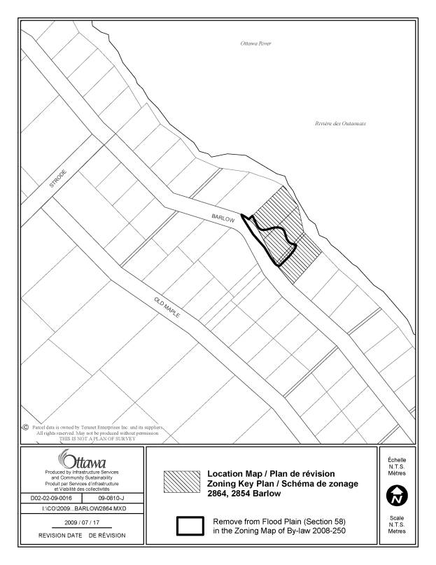
8. 2854 and 2864 Barlow Crescent Ward 5 |
The zoning maps indicate an isolated
portion of the flood plain overlay on the subject lands and on an unaddressed
area between this lot and 2880 Barlow. However, the Mississippi Valley
Conservation Authority has advised that this area is no longer within the
flood plain, and the overlay should be removed. |
Amend the zoning maps to remove the flood
plain overlay from the subject lands as shown in Document 3. |
|
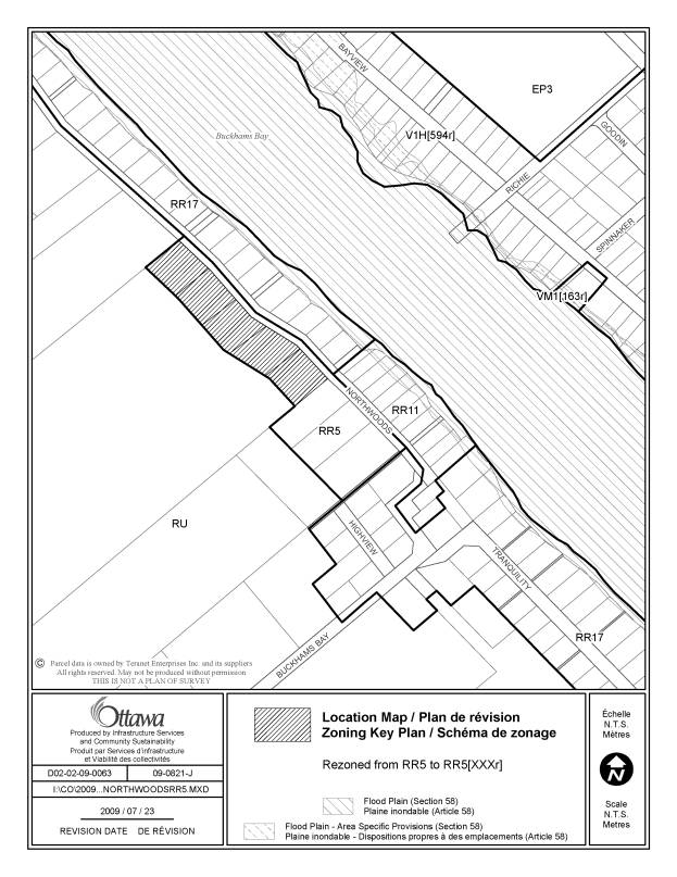
9. West side of Northwoods Drive,
northwest of Buckhams Bay Road Ward 5 |
The incorrect lot area was assigned to
this subzone, rendering five of eight properties non-complying. |
Amend the zoning map by rezoning the
subject lands from RR5 to RR5 [xxxr], as shown in Document 3. Add exception [xxxr] to Table 240, Column
V to read as follows, “-minimum lot area 3600 square metres” |
|
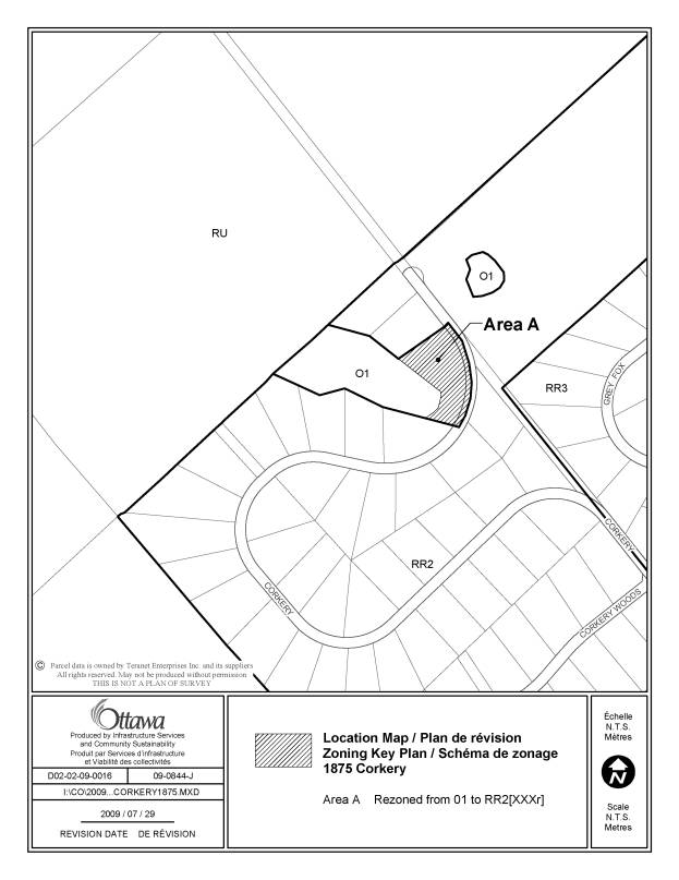
10. 1875 Corkery Road Ward 5 |
Amend the zoning map to rezone a portion
of 1875 Corkery Road from OI to RR2 [xxxr] as shown on Document 3. Add a new exception to Section 240 with the following provision: - minimum setback from the boundary of
the O1 zone: 10 metres |
LIST OF
SITE-SPECIFIC LOCATION MAPS DOCUMENT
3
|
Location Maps (attached) |
|
79 Whitestone Drive |
|
81 Somerset Street |
|
560 Rideau Street |
|
1573 Stittsville Main Street |
|
971 Richmond Road |
|
London Terrace/ Mart Circle Area |
|
160-64 Mafeking |
|
Henri Lauzon/Forestcrest Area |
|
Area generally bounded by Premier Avenue on the south, Northwestern Avenue on the east, Pontiac Street on the north and Cowley Avenue to the west. |
|
3730, 3738, 3746 and 3868 Innes Road |
|
Hartsmere Drive near the intersection of Arrowwood Drive |
|
Scotiabank Place Area |
|
1424 Commodore Lane |
|
3004 and 3016 Dunning Road |
|
1669 Diamondview Road |
|
2854 and 2864 Barlow Crescent |
|
West side of Northwoods Road, northwest
of Buckhams Bay Road |
|
1875 Corkery Road |