|
1. Ottawa
pedestrian plan Plan de
circulation pietonnière d’Ottawa |
Committee Recommendations as amended
That Council:
1.
Approve the draft Ottawa
Pedestrian Plan (Document 1) including:
(a)
The policy and technical
recommendations (Document 2);
(b)
The Pedestrian Improvement
Process (Document 3) to be utilized for network refinement and proactive
implementation of new sidewalks;
(c)
The Rating System for New
Sidewalk and Pathway Requests (Document 4) to be utilized for analysis and
priority ranking for responsive implementation of new sidewalks;
(d)
The Pathway Winter Maintenance
Criteria for determining pathways to receive winter maintenance including
operating and maintenance cost impacts of applying the new criteria.
2. Direct staff to put forward, for consideration as part of the annual Capital Budget deliberations a request for funding of $3.5 Million per year to support, planning and implementation of sidewalks and pathways and pedestrian education and promotion activities.
3. That Ottawa East, Ottawa Inner and Ottawa Centre be moved
to the High/Short Term Priority section of Table 7.7.
4. That the last two words
of Recommendation 8.8 be deleted.
5. That the review of design elements of street crossings at
wide arterial intersections that involve pedestrian islands (Recommendation
9.1), include the consideration of pedestrian signal activation devices on
these pedestrian islands.
6. That
Document 3 be amended by adding:
“Concerning what is ‘desirable in any given community’, Guidelines
attached to any of the City’s Heritage Conservation Districts (HCDs) will
determine desirability for pedestrian improvements.”
at the end of the first
paragraph.
7. That a new criteria (and weighting) be added to
“Pedestrian Destination/Generators” at Document 4:
Pedestrian connections
between separated communities……………10.
8. That all Community Design Plans be required to have a
local pedestrian plan;
And that local pedestrian
plans from Community Design Plans then be applied to the master Pedestrian
Plan.
9. That financial resources sufficient to fund an
Environmental Assessment for the Clegg/Fifth Avenue bridge be included for
debate in the 2010 budget.
10. That a permanent pedestrian connection
between Donald Street and Somerset Street East be examined in 2010 and that
provision for the study be included in the draft 2010 budget.
Recommandations
Modifiées du comité
Que
le Conseil :
1.
approuve la version préliminaire du Plan de
circulation piétonnière d’Ottawa (Document 1), y compris :
(a)
les recommandations politiques et techniques
(Document 2);
(b)
le processus d’amélioration de la circulation
piétonnière (Document 3), qui sera utilisé pour perfectionner le réseau et
aménager de nouveaux trottoirs de façon proactive;
(c)
le système d’évaluation des demandes de nouveaux
trottoirs et sentiers (Document 4), qui sera utilisé
pour évaluer la priorité des projets d’aménagement de trottoirs selon la
situation;
(d)
les critères d’entretien hivernal des sentiers
servant à déterminer les sentiers à entretenir l’hiver, y compris les répercussions
de l’application des nouveaux critères sur les
coûts de fonctionnement et d’entretien.
2. charge
le personnel de présenter, aux fins d’examen dans le cadre des délibérations
annuelles sur le budget des immobilisations, une demande de financement de
3,5 millions de dollars par année afin de financer, de planifier et
d’aménager des trottoirs et des sentiers, d’informer le public et d’organiser
des activités de promotion.
3. Que Ottawa-Est, Ottawa-intérieur et Ottawa-Centre soient
déplacés à la section Priorité élevée/à court terme du tableau 7.7.
4. Que les deux derniers
mots de la Recommandation 8.8 soient enlevés.
5. Que l’examen des éléments de conception des points
d’intersection des grandes artères qui comportent des refuges pour piétons
(Recommandation 9.1) inclue la possibilité d’installer des dispositifs
d’activation des feux de signalisation pour piétons sur ces refuges.
6. Que
l’on ajoute au Document 3 le paragraphe suivant :
« En ce qui concerne ce qui est « souhaitable dans toute
collectivité donnée », les lignes directrices rattachées à tout district
de conservation du patrimoine (DCP) de la Ville détermineront le bien-fondé des
améliorations à l’intention des piétons »
à la fin du premier
paragraphe.
7. Qu’un nouveau critère (et une nouvelle pondération) soit
ajouté à la section « Provenances/destinations des piétons » du
Document 4 :
Parcours piétonniers reliant
les collectivités séparées……………10.
8. Que tous les plans de conception communautaire soient
tenus d’avoir un plan local de la circulation piétonnière;
Et que les plans locaux de
la circulation piétonnière tirés des plans de conception communautaire soient
par la suite appliqués au plan directeur de la circulation piétonnière.
9. Que les ressources financières suffisantes pour financer
une évaluation environnementale pour le pont de la rue Clegg/l’avenue Fifth
soient incluses pour discussion dans le budget de 2010.
10. Qu’un parcours piétonnier permanent
reliant la rue Donald et la rue Somerset Est soit examiné en 2010 et que les
dispositions relatives à l’étude soient incluses dans le budget provisoire de
2010.
Documentation
1. City Manager’s report, Infrastructure
Services and Community Sustainability dated 10 June 2009 (ACS2009-ICS-PGM-0065).
2. Extract
of Draft Minute, 17 June 2009, to be distributed prior to Council.
Report to/Rapport au:
Transportation Committee
Comité des transports
and Council / et au Conseil
10 June 2009 / le 10 juin 2009
Submitted by/Soumis par:
Nancy Schepers, Deputy City Manager/Directrice municipale
Adjointe,
Infrastructure Services and Community Sustainability/Services
d’infrastructure et
Viabilité des collectivités
Contact/Personne
ressource: Vivi Chi,
Manager/Gestionnaire, Transportation Planning/Planification des transports,
Planning and Growth Management/Urbanisme et Gestion de la croissance
(613) 580-2424 x 21877, Vivi.Chi@ottawa.ca
|
City-wide |
Ref N°:ACS2009-ICS-PGM-0065 |
|
SUBJECT: |
OTTAWA PEDESTRIAN PLAN |
|
|
|
|
OBJET: |
plan de circulation
pietonniere d’ottawa |
REPORT RECOMMENDATIONS
That Transportation Committee recommend that Council:
2.
Approve the draft Ottawa
Pedestrian Plan (Document 1) including:
(a)
The policy and technical
recommendations (Document 2);
(b)
The Pedestrian Improvement
Process (Document 3) to be utilized for network refinement and proactive
implementation of new sidewalks;
(c)
The Rating System for New
Sidewalk and Pathway Requests (Document 4) to be utilized for analysis and
priority ranking for responsive implementation of new sidewalks;
(d)
The Pathway Winter Maintenance
Criteria for determining pathways to receive winter maintenance including
operating and maintenance cost impacts of applying the new criteria.
3.
Direct staff to put forward,
for consideration as part of the annual Capital Budget deliberations a request
for funding of $3.5 Million per year to support, planning and implementation of
sidewalks and pathways and pedestrian education and promotion activities.
RECOMMANDATIONS DU RAPPORT
Que le Comité des transports recommande au
Conseil :
2.
d’approuver la version préliminaire du Plan de
circulation piétonnière d’Ottawa (Document 1), y compris :
(a)
les recommandations politiques et techniques
(Document 2);
(b)
le processus d’amélioration de la circulation
piétonnière (Document 3), qui sera utilisé pour perfectionner le réseau et
aménager de nouveaux trottoirs de façon proactive;
(c)
le système d’évaluation des demandes de nouveaux
trottoirs et sentiers (Document 4), qui sera utilisé
pour évaluer la priorité des projets d’aménagement de trottoirs selon la
situation;
(d)
les critères d’entretien hivernal des sentiers
servant à déterminer les sentiers à entretenir l’hiver, y compris les
répercussions de l’application des nouveaux critères sur les
coûts de fonctionnement et d’entretien.
3.
de charger le personnel de présenter, aux fins
d’examen dans le cadre des délibérations annuelles sur le budget des
immobilisations, une demande de financement de 3,5 millions de dollars par
année afin de financer, de planifier et d’aménager des trottoirs et des
sentiers, d’informer le public et d’organiser des activités de promotion.
EXECUTIVE SUMMARY
Assumptions
and Analysis:
This report
presents the draft Ottawa Pedestrian Plan (Document 1) to
guide the City’s growth and inform decision-making in support of walking - a
transportation mode that is universally accessible, environmentally healthy and
economically feasible.
The Ottawa
Pedestrian Plan provides a vision and policy framework for pedestrian travel,
establishes objectives, compiles best practices and standards, and further
defines actions and processes for better integrating pedestrian travel into the
urban landscape and creating a culture of walking for Ottawa. The Plan supports improvements to the
walking network and walking environment, enhancing pedestrian connection to
transit and improving the safety and comfort of pedestrians, to promote
walking.
Chapters 1.0 through 6.0 of the draft Ottawa Pedestrian Plan provide an introduction, detail the study process, explore background documents and make the case for improved walkability in Ottawa. The Plan contains both policy and technical recommendations designed to equip the City to deliver services, manage growth, develop and implement new programs and facilities in a manner that strengthens the culture of walking. The recommendations are presented contextually in Chapter 7.0 through Chapter 12.0. For ease of reference, the full recommendations of the draft Ottawa Pedestrian Plan are presented in Document 2.
To improve the walking environment the Ottawa Pedestrian Plan introduces a number of pedestrian-supportive guidelines and best practices aimed at improving the built form and the pedestrian experience through addressing safety and accessibility.
For comprehensive planning of pedestrian facilities the draft Ottawa Pedestrian Plan examines all levels of the pedestrian planning process from broader pedestrian policy down to tangible pedestrian design at the community and site plan level and recommends integration of the methodologies introduced in the Pedestrian Improvement Process into all development and reconstruction projects with the objective of improving the pedestrian environment in a holistic manner, ensuring projects do not take place in isolation of the greater urban context and pre-empting pedestrian network discontinuities and deficiencies.
The draft Ottawa Pedestrian Plan addresses expanding the existing pedestrian network through introduction of a new base pedestrian network to form the basis for refinement and implementation of the pedestrian network through application of a new proactive Pedestrian Improvement Plan methodology (Document 3) and an improved responsive Rating System for New Sidewalk Requests (Document 4).
To improve winter maintenance the draft Ottawa Pedestrian Plan supports the review of current sidewalks maintenance standards and recommends pathway winter maintenance criteria that consider the pathway’s function in the context of the overall pedestrian network.
The Plan
recommends the development and implementation of pedestrian educational and
promotional programs including a synergistic review of existing walking-based
promotions to change public attitude towards walking and ultimately encourages
people to walk and reduce their dependence on the automobile.
Legal/Risk
Management Implications:
There are no
legal or risk management impediments to the implementation of this report’s
recommendations, and there adoption will limit the City’s potential exposure to
claims arising from the public’s use of City sidewalks and pathways.
Financial Implications:
This report recommends that staff be directed to put
forward, for Council consideration as part of the 2010 Capital Budget
deliberations, an annual capital request of $3.5M to support implementation of
the key outcomes of the Pedestrian Plan.
As presented in the 2009 Capital Budget, the 2010 and 2011
forecasts for Strategic Initiatives include projects that total $70M in each
year. The recommended Strategic Initiative projects were based on Council's
stated term priorities. Within this category, funding of $0.180M in 2010 and
$1.197M in 2011 was identified for the Sidewalk/Pathway Links Program. This
request will be reviewed within the overall Strategic Initiative funding
envelope.
Should Committee and Council approve report Recommendation 2,
the $3.5M and the associated operating budget impact of approximately $47K will
be identified for Council consideration within the Strategic Initiative
category of the 2010 Draft Capital Budget.
Public
Consultation/Input:
The Study involved
an extensive consultation process to provide opportunity for residents,
community representatives and professionals to provide inputs into the
Pedestraian Plan Study. A Public
Advisory Committee (PAC) and a Technical Advisory Committee (TAC) were formed
to provide inputs into the plan. For
broader public consultaion, the City
held four public open houses. A summary
of the public consultation comments received on the Plan is included in Document 6.
RÉSUMÉ
Ce rapport présente la version préliminaire du
Plan de circulation piétonnière d’Ottawa (Document 1), qui a pour objectif
d’orienter la croissance de la ville et de renseigner les décideurs pour que
l’on favorise la marche, un moyen de transport universel, bon pour
l’environnement et économiquement viable.
Le Plan de circulation piétonnière d’Ottawa
offre une vision et un cadre stratégique pour la circulation piétonnière, fixe
des objectifs et présente les normes et les pratiques exemplaires. On y décrit
en profondeur les mesures et les processus nécessaires à l’intégration de la
circulation piétonnière en milieu urbain et à l’implantation de l’habitude de
marcher chez les résidents. On y propose des améliorations au réseau piétonnier
et à son environnement, comme le développement de voies piétonnières reliées
aux services de transport en commun et l’optimisation de la sécurité et du
confort des piétons, pour stimuler l’utilisation ce moyen de transport.
On trouve dans les chapitres 1.0 à
6.0 de la version préliminaire du Plan de circulation piétonnière
l’introduction, le compte rendu du processus d’étude, la description des
documents d’information et la présentation d’arguments pour l’amélioration du
réseau piétonnier de la ville d’Ottawa. On y formule des recommandations
politiques et techniques conçues pour aider la Ville à offrir le service, à
gérer la croissance ainsi qu’à élaborer et mettre en place de nouveaux programmes
et des installations de façon à favoriser l’habitude de marcher. Dans les
chapitres 7.0 à 12.0, les recommandations sont présentées dans leur
contexte. Toutes les recommandations de la version préliminaire du Plan de
circulation piétonnière d’Ottawa sont décrites dans le Document 2 pour en
faciliter la consultation.
Le Plan de circulation piétonnière d’Ottawa
offre plusieurs directives et pratiques exemplaires visant à optimiser
l’environnement pédestre, comme des moyens d’améliorer la forme bâtie et de
rendre l’expérience des marcheurs plus agréable par une sécurité et une
accessibilité accrues.
Afin que l’on puisse adopter une perspective
globale de la planification des installations piétonnières, la version
préliminaire du Plan de circulation piétonnière d’Ottawa examine tous les
aspects du processus de planification, des politiques générales en matière de
circulation piétonnière aux mesures concrètes de conception à l’échelle de la
communauté et des sites. On y recommande l’utilisation des méthodologies
présentées dans le Processus d’amélioration de la circulation piétonnière pour
tous les projets de construction et d’aménagement en vue d’améliorer
l’environnement pédestre de façon globale, d’éviter que ces projets soient
entrepris sans tenir compte du contexte urbain général et de prévenir des
discontinuités et des lacunes dans le réseau piétonnier.
La version préliminaire du Plan de circulation
piétonnière d’Ottawa propose d’agrandir le réseau pédestre en place en créant
un nouveau réseau qui sera à la base des travaux éventuels de raffinement et
d’aménagement, et ce, à l’aide d’une nouvelle méthodologie tirée du Plan
d’amélioration de la circulation piétonnière (Document 3) et du système d’évaluation des demandes de nouveaux
trottoirs et sentiers (Document 4) adapté au milieu.
Afin d’améliorer l’entretien hivernal, on
propose dans la version préliminaire du Plan de circulation piétonnière
d’Ottawa de réviser les normes actuelles en la matière et on y recommande des
critères d’entretien des sentiers qui tiennent compte de leur fonction dans le
réseau en général.
On recommande dans le Plan d’élaborer et de
mettre en œuvre des programmes d’information et de promotion de la marche,
ainsi que de réaliser une révision coordonnée des campagnes de promotion en
place pour modifier l’opinion du public et finalement l’encourager à opter pour
ce moyen de transport au lieu de l’automobile.
Implications juridiques et de
gestion des risques :
Il n’existe pas d’implications
juridiques ou de gestion des risques pouvant freiner la mise en œuvre des
recommandations du présent rapport; ces dernières contribueront même à réduire
le risque d’éventuelles demandes d’indemnisations à la Ville découlant de
l’utilisation des trottoirs et des sentiers.
Répercussions financières :
Il est recommandé dans le présent
rapport que le personnel présente au Conseil, dans le cadre des
délibérations sur le budget des immobilisations de 2010, une demande de
financement annuelle de 3,5 millions de dollars afin de financer les
principaux éléments du Plan de circulation piétonnière.
Comme il a été indiqué dans le
budget des immobilisations de 2009, les prévisions de 2010 et
de 2011 pour les Initiatives stratégiques comprennent des projets
totalisant 70 millions de dollars par année. Ces projets sont liés aux
priorités fixées par le Conseil. Dans cette catégorie, on avait attribué un
financement de 0,180 millions de dollars en 2010 et de
1,197 millions de dollars en 2011 au Programme de nouveaux réseaux de
trottoirs et de sentiers. Cette demande sera révisée dans l’enveloppe de
financement globale des Initiatives stratégiques.
Si le Comité et le Conseil
approuvent la recommandation 2, un montant de 3,5 millions de dollars
ainsi que des frais de fonctionnement supplémentaires d’environ 47 000 $
seront ajoutés à la catégorie des Initiatives stratégiques du budget
préliminaire des immobilisations de 2010, aux fins d’examen par le
Conseil.
Consultation publique/commentaires :
L’étude a donné lieu à un processus de
consultation approfondi dans le cadre duquel les résidents, les représentants
des communautés et les professionnels on pu émettre leur avis sur l’étude du
Plan de circulation piétonnière. Un comité de consultation publique et un
comité consultatif technique ont été créés pour participer à l’élaboration du
plan. La Ville a aussi organisé quatre réunions portes ouvertes pour entendre
les commentaires du public. Le Document 6 présente un résumé des
commentaires reçus à la suite de ces consultations.
BACKGROUND
This report presents a draft of the City’s first Pedestrian Plan. The Plan will guide the City’s growth and inform decision-making in support of walking - a transportation mode that is universally accessible, environmentally healthy and economically feasible.
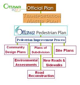
Walking is a form of active transportation that conserves energy and reduces the pressure on the road network while preserving the environment, improving public health and supporting economic activities. The City is committed, through the Guiding Principles and Active Transportation Vision policies of the Official Plan (OP) and Transportation Master Plan (TMP), to provide a strong pedestrian focus for an Ottawa with transportation and land use practices and an urban vitality conducive to better pedestrian and pedestrian/transit conditions. The OP mandates that the City will prepare a pedestrian plan to guide the City in the development and implementation of pedestrian programs and facilities while the TMP further reiterates that and recommends the implementation of an integrated pedestrian network and supporting strategies. In turn, the Ottawa Pedestrian Plan informs the TMP and guides the planning processes to steer growth with a focus on an improved pedestrian environment. Figure 1 illustrates an overview of hierarchy of the City’s pedestrian planning documents:
Figure 1: The hierarchy of pedestrian planning
documents:
The Council approved City Strategic Plan (2007-2010) also provides a pedestrian supportive policy framework and the draft Ottawa Pedestrian Plan responds to nine Priority Objectives in several key Priorities including: Transportation, Infrastructure Renewal, Environmental, Transit; and, Planning and Growth Management. How the draft Ottawa Pedestrian Plan responds to this direction are discussed further in this report.
The OP and TMP set aggressive targets for an increased walking modal share from 9.3 per cent in 2005 to 10 per cent in 2031. The number of walking trips is estimated to increase by 34 per cent by the end of the planning horizon. This reflects the positive impact of the Official Plan’s emphasis on compact, mixed-use, pedestrian friendly development, which will be countered by significant growth in longer trips that cannot reasonably be made on foot. Table 1 extrapolates from the TMP the estimated 2005 and the projected 2031 travel demand by all modes including the walking mode expressed in person-trips:
Table 1: Projected Travel Demand –
City-wide (Morning peak hour)
|
Travel Modes |
2005 |
2031 |
Growth |
|
20,100 |
26,800 |
+ 33% |
|
|
Cycling |
3,600 |
8,600 |
+ 140% |
|
Transit |
44,500 |
78,300 |
+ 76% |
|
Automobile |
146,600 |
182,300 |
+ 24% |
|
Total – all
trips |
214,800 |
296,000 |
+ 38% |
The Statistics Canada 2006 Census data (Place of Work, Place of Residence) for City of Ottawa further supports this and illustrates the challenge this represents in shifting public travel choices away from the vehicle to walking and other forms of active transportation. Figure 2 depicts the 2006 Census commuter transportation mode data for the employed labour force 15 years and over with usual place of work or no fixed workplace address:
Figure 2: Commuter Profile by Mode
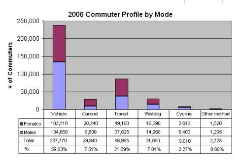
Source: Statistics Canada, 2006 Census, Profile data
for City of Ottawa
Following Council’s direction, in 2005, the former Public Works and Services Department, Traffic and Parking Operations Branch brought forward for Transportation Committee and Council’s approval the Terms of Reference (ToR) for the development of the Pedestrian Plan (ACS2005-PWS-TRF-0013). Subsequently, Stantec Consulting Limited was retained to undertake the Pedestrian Plan Study on the City’s behalf.
The pedestrian plan study commenced with a best practice review of current trends and initiatives in pedestrian planning. Over the past several decades the planning and design of North American communities has focused on moving vehicles quickly and efficiently, resulting in the creation of neighbourhoods and places favourable to automobile travel and less conducive to walking and active transportation. Fortunately, this trend is shifting with leading municipalities such as Ottawa moving toward more liveable, walkable communities in support of sustainable development. Current progressive trends in city design are tending towards pedestrian-friendly new and in-fill communities with reintroduction of sidewalks and pathways, pedestrian friendly streetscaping, pedestrian-scale building fronts and street lighting, shared mixed-uses and complete streets with features making the public right-of-way more inviting for people to travel by walking. Lifestyle choices too are resulting in residents gravitating toward communities where walking is integral to the design of the built environment.
The best practice review revealed that pedestrian-supportive concepts are leading edge and not yet widely accepted and applied. The Ontario Professional Planners Institute (OPPI) only recently (2007) released “Healthy Communities Sustainable Communities”, a discussion paper that defines sustainability and demonstrates walking-friendly principles that can be applied to urban design, transportation and infrastructure services and design. Concepts such as “Complete Streets” – streets designed and operated safely for all users – and “Smart Growth” – recognizing the connection between development and quality of life are innovative.
The walkability of the city - which is a direct measure of the liveability of the city - is inherently linked to the achievement of multiple social and economic benefits including:
- Environmental (reduced GHG emissions, improved air quality, noise reduction, reduced energy use);
- Health (increased physical activity, lower health care costs);
- Economic Development (consumer activity, increased property values, reduced fuel expenditures, reduced parking costs);
- Land Use Accessibility (distance to transit and amenities, network continuity, removal of barriers, improving unsatisfied demand);
- Sustainable Growth, (land use patterns, mixed use, density);
- Transportation Demand Management (TDM) (congestion reduction, reduced delays, efficient infrastructure investments);
- Quality of Life (accessibility, convenience, personal health and well being);
- Safety (perception of safety, personal security);
- Community Cohesion (quality of public realm, neighbourhood vitality, social engagement, cultural cohesion);
- Social Capital (productivity, social norms, cooperation, social infrastructure).
The Pedestrian Plan study involved an extensive consultation process offering opportunity for residents, community representatives, and professionals to provide input into the draft Ottawa Pedestrian Plan. The collaborative consultation involved a series of events (workshops, public open houses, presentations and a pedestrian survey) designed to gain insight into the pedestrian perspective and identify key principles and themes for making Ottawa more pedestrian friendly. This process facilitated development of key strategies for changing travel behaviour to increase walking in Ottawa and solutions for making the walking network more attractive and efficient. The primary themes for action that emerged from the inter-active consultation process were:
- Social Marketing – recognition of unfavourable societal attitudes toward walking and the need to facilitate a wholesale shift such that walking is an accepted and respected transportation choice;
- Urban Design and Land Use Planning – recognition that long-term application of dispersed, multi-nucleic development patterns featuring curvilinear street layouts has had a dramatic effect on Ottawa’s walkability leading to isolated residential communities and the need for pedestrian supportive community design incorporating compact, mixed-use development integrated with transit, employment, amenities, and natural features within comfortable walking distance;
- Facilities – recognition of the importance of the walking environment for walking to be an attractive alternate to travel by automobile and the need to provide a direct, continuous, well connected network of accessible, with comfortably designed sidewalks, pathways and structures to facilitate access to key community destinations including transit, schools, parks and greenspace, community centres, employment, retail, etc.;
- Targeted Implementation – recognition of fiscal restraints and monetary challenges associated with the provision of programs, infrastructure and services and the need to clearly establish pedestrian priorities to optimize funding;
- Institutional Strengthening – recognition of the challenges of incorporating pedestrian-related policy into daily work practices within the bureaucratic civic structure and the need to for the Ottawa Pedestrian Plan to provide direction and inform decision-making processes and business practices across all Divisions.
Areas of focus to create an environment conducive to walking were also identified:
- Streetscape design;
- Sidewalk design;
- Maintenance;
- Street crossings and traffic calming;
- Traffic signal operation;
- Planning;
- Enforcement;
- Pedestrian Network.
The draft Ottawa Pedestrian Plan comprehensively responds to these identified themes through a series of policy and technical recommendations that address: the pedestrian network with responsive and proactive implementation strategies; civic planning; pedestrian facility design; safety and accessibility; maintenance and rehabilitation; and, education and enforcement.
DISCUSSION
The City recognizes that a sustainable urban environment supports a balanced transportation system with increased use of active transportation modes and decreased automobile use. Walking forms a critical part of every person-trip as most travel begins and ends with walking. The most vibrant, economically successful commercial areas in Ottawa (e.g.: By-Ward Market; Glebe; Manotick Village; Beechwood Ave; Preston St; Elgin St) depend on high volumes of pedestrian movement. Likewise, Ottawa’s extensive tourism industry relies on a high quality pedestrian environment to attract visitors. A healthy, prosperous and safe Ottawa depends on a vibrant walking environment.
The draft Ottawa Pedestrian Plan provides a vision and policy framework for pedestrian travel, establishing objectives, compiling best practices and standards, and further defining actions and processes for better integrating pedestrian travel into the urban landscape and creating a culture of walking for Ottawa. The plan supports improvements to the walking network and walking environment, enhancing pedestrian connection to transit and improving the safety and comfort of pedestrians, to promote walking.
It is important to note that the Ottawa Pedestrian Plan is not intended to be an encyclopaedic “how-to” design manual or constitute ‘City Standard’. The role of the plan is to provide general policy and guidance acknowledging that the base pedestrian network, concepts and demonstrated best practices will require ‘context-based’ application with ‘context-based’ design solutions, and may not be appropriate or achievable in all circumstances. The Plan also informs day-to-day decision making to steer City growth with a focus on an improved pedestrian environment that supports and promotes walking.
The content of the draft Ottawa Pedestrian Plan (Document 1) is presented in three primary parts:
1. Part One - Building the Case for Walkability in Ottawa (Chapters 1-5): benefits of walkable communities; current trends and best practices; and, outcomes of the extensive consultation process.
2. Part Two - The Strategy and the Network (Chapters 6-7): existing network inventory; examination of development patterns; proposed base pedestrian network; and, recommended policy, methodology and an implementation strategy for achieving an integrated pedestrian network.
3. Part Three - Planning, Design and the Supporting Processes (Chapters 8-12): planning for pedestrians; guidelines for design, safety and accessibility; maintenance and rehabilitation; education and promotion; and, recommended policy, methodology and process for improving pedestrianism including development of a Pedestrian Charter for Ottawa.
The Plan contains both policy-oriented and technical-oriented recommendations designed to equip the City to deliver services and manage growth with a pedestrian persuasion. The plan recommendations are presented contextually throughout Chapters 7 to Chapter 12. For ease of reference, the full recommendations of the draft Ottawa Pedestrian Plan are presented in Document 2. An overview of the key areas addressed by the Plan follows.
Base Pedestrian
Network
For walking to become an attractive and feasible travel mode, the provision of a high quality and comfortable walking experience is essential; a significant factor of that experience is the quality of the pedestrian network. The City’s Official Plan and Transportation Master Plan set out very basic pedestrian facility requirements, mandating sidewalks along arterial and collector roads. The draft Ottawa Pedestrian Plan establishes the City’s first base pedestrian network – an inventory compiling both existing and proposed facilities, presented in Schedules 1 through 17 of the draft Plan (Document 1). These schedules correspond with the Origin-Destination (O/D) Survey Districts[1]. In establishing the proposed base pedestrian network, each district underwent detailed O/D analysis to develop strategies and key considerations for network improvements.
The draft Ottawa Pedestrian Plan further envisions
continual refinement to this base pedestrian network at the community level -
proactively through introduction of a new Pedestrian Improvement Process
methodology (Document 3) and
responsively through improvements to the Rating System for New Sidewalk
Requests (Document 4). The base network will serve as a means to
inform the Official Plan, Transportation Master Plan and all other planning
processes. It is important to note that
the pedestrian network will continually evolve over time as neighbourhoods and
the City evolve.
To improve administration of the pedestrian network, the plan recommends corporately compiling pedestrian inventory master data under a single corporate application and further recommends establishment of an interdepartmental working group comprising staff involved in planning, design, maintenance and rehabilitation of pedestrian facilities to better coordinate overall efforts in pedestrian network management.
Pedestrian
Improvement Process – Proactive Provision of Pedestrian Facilities
While pedestrian travel is strongly influenced by the pedestrian network similar to other travel modes being influenced by the road network, there are key fundamental differences between walking and other modes that are unique to pedestrianism in that pedestrian trips tend to be short in distance, geographically contained, direct based on line of desire, and travel takes place without or beyond formalized facilities. As such, the "corridor” concept of conventional transportation planning is less applicable to pedestrian facility planning than it is for planning for transit, cycling and vehicles. As well, geographic variations in land uses vary the density of pedestrians encountered in different areas of the city, implying that the density and type of pedestrian infrastructure should vary relative to the characteristics of the community. These concepts in pedestrian planning support the neighbourhood approach to pedestrian planning envisioned by the draft Ottawa Pedestrian Plan.
Pedestrian
Improvement Process
The draft Plan proposes a preliminary framework - the Pedestrian Improvement Process (Document 3) - to proactively examine the base pedestrian network at the neighbourhood level and refine the pedestrian facilities that will be necessary or desirable in a particular community to support the walking transportation mode and accommodate the needs of pedestrians of all ages and abilities based on a logical analysis of pedestrian origins, routes and destinations/attractions, examining the relationship between route and neighbouring land use, and understanding the needs of the user groups. The focus of the Pedestrian Improvement Process is on connecting the community to key pedestrian destinations, mainly transit, schools, public facilities, and retail/commercial and employment centres. The process is intended to be applied equally to both existing and planned neighbourhoods and developments.
Prioritizing the Application of the
Pedestrian Improvement Process
The geographic distribution of current sidewalks is not broad, with the vast majority of existing sidewalks situated in the downtown. A significantly higher number of requested sidewalks originated from the middle-urban and suburban areas with the greatest number of requested sidewalks and the greatest total length of requested sidewalks found in the middle-urban region.
To establish priority for selection of neighbourhood communities for study and application of Pedestrian Improvement Process, the draft Pedestrian Plan applied the following criteria:
- The existing pedestrian network;
- Diversity of development patterns in neighbourhoods;
- Linkages to key destinations including transit, schools, institutions, community facilities, retail and commercial amenities, employment centres, greenspace and parkland;
- A combination of significant physical barriers to pedestrian travel;
- The number of sidewalks requested by the community (mined from the Sidewalks Program database);
- Public and stakeholder input gathered at open houses and outcomes from the Network Development Approach exercises.
Based on these criteria, Table 2 outlines the recommended priority areas for the Pedestrian Improvement Process, ranked as: high priority short-term needs, moderate priority medium-term needs, and lower priority long-term needs.
Table 2: Recommended Priority Areas
for the Pedestrian Improvement Process
|
Priority |
OD Survey District |
Notes (Where Applicable) |
|
High/Short Term |
Kanata/Stittsville |
|
|
Merivale |
|
|
|
Alta Vista |
|
|
|
Bayshore/Cedarview |
Area bounded by
the Ottawa River to the north, Highway 416 to the west, the railway corridor
to the south, and Greenbank to the east. |
|
|
Hunt Club |
Area bounded by
railway switchyard to the north, Airport Parkway to the west, Lester to the
south and Conroy to the east. |
|
|
Rural Southeast |
Villages of
Metcalfe and Greely |
|
|
Rural Southwest |
Village of
Manotick |
|
|
|
Orleans |
|
|
|
Beacon Hill |
|
|
Moderate/ Medium Term |
South Nepean |
|
|
Hunt Club |
All areas other
than identified as high (see above) |
|
|
Ottawa West |
Area west of
Island Park |
|
|
Rural West |
Hamlets and
Villages |
|
|
Rural Southwest |
Hamlets and
Villages unless identified as high (see above) |
|
|
Rural Southeast |
Hamlets and
Villages unless identified as high (see above) |
|
|
Rural East |
Hamlets and
Villages |
|
|
Low/Long Term |
Ottawa West |
Area east of
Island Park |
|
Rural Southeast |
Rural Areas |
|
|
Rural Southwest |
Rural Areas |
|
|
Rural East |
Rural Areas |
|
|
Rural West |
Rural Areas |
|
|
Ottawa East |
|
|
|
Ottawa Inner |
|
|
|
Ottawa Centre |
|
Pilot
Pedestrian Improvement Process
The draft Ottawa Pedestrian Plan suggests that implementation of a pilot Pedestrian Improvement Process in two high-priority and significantly different communities in the urban area- as a means to more fully develop the methodologies and provide opportunity to test and refine the process prior to applying the proposed Pedestrian Improvement Process. However, it would also be prudent to include a rural area to test the methodologies. The three proposed areas for the pilot process are as follows:
- Urban area 1: Community bounded by the Ottawa River to the north, Highway 416 to the west, the railway corridor to the south, and Greenbank/Pinecrest to the east (Qualicum, Graham Park, Leslie Park, Redwood Park, Bayshore, Britannia Heights, and West Britannia).
- Urban area 2: community bounded by the railway yard to the north, Airport Parkway to the west, Lester to the south and Conroy to the east (South Keys, Greenboro, Hunt Club Park, Upper Hunt Club, Sawmill Creek, Timbermill, Emerald Woods, Blossom Park).
- Rural area: Communities of the Village of Metcalfe and Village of Greely.
Maps depicting these areas are provided in Document 5.
In addition to applying the Pedestrian Improvement Process to the New Sidewalk Program, it is fundamental that the process be applied to all planning and development processes such as Community Design Plans, Plans of Subdivision, site plans, road reconstruction and new road construction, hence these projects not continue to result in pedestrian network discontinuities with the City perpetually inheriting network deficiencies.
Managing Community Requests for Sidewalks – Reactive Provision of
Pedestrian Facilities
Currently, the implementation of most new city-built sidewalks (not associated with new road construction or road reconstruction) is addressed through the New Sidewalk Program (New Sidewalks and Sidewalk/Pathway Links Program). This program deals mainly with ongoing community requests for new sidewalks and pathways with an objective of completing discontinuities in the existing pedestrian network. While the draft Ottawa Pedestrian Plan introduces new concepts in community pedestrian network planning, there is a need to continue to manage ongoing community requests for new sidewalks and pathways and to complete network discontinuities in individual priority locations that will not be addressed proactively through the Pedestrian Improvement Process or not subject to development application.
In 2001, following the amalgamation of the former municipalities, an interim process to evaluate all requests for new sidewalks and to rank each requested location based on the following criteria was put into place:
- Pedestrian Generators – presence and type of school, seniors’ facilities, transit routes, commercial and shopping districts, recreation centers, other institutions
- Traffic Characteristics – speed limits, traffic volume levels, and adjacent land use
- General Conditions – missing link, existing sidewalks, evidence of pedestrian activity (beaten path), street geometry
Each criterion is assigned a numerically weighted value and based on the total overall score, each location receives a priority ranking relative to all other locations that have been assessed. Once a location is considered as a possible candidate, a feasibility review is initiated to consider possible limitations including the presence of constraints such as mature trees, insufficient road width, adjacent property issues, construction obstacles, cost limitations, as well as opportunities for coordination with other City’s programs.
During the Pedestrian Plan Study, the interim process was reviewed and several issues were identified. Of primary concern was that the process has no inherent pass/fail mechanism to eliminate those locations that do not fit the intended scope of the program to complete discontinuities in the exiting pedestrian network or where a sidewalk is not necessary to support community connectivity and access of key pedestrian destinations. Consequently, all requests for sidewalks and pathways received by the City were entertained under the existing program regardless of their eligibility. As a result, the candidates’ list has grown substantially, well outpacing implementation funding, where approximately 300 outstanding candidate segments reside on the candidate list.
To address these issues and establish a new system aligned with the Program’s mandate and aligned with the overall objective of improving neighbourhood walkability, and connecting pedestrians to key points of destination, a new Rating System for New Sidewalk Requests is proposed that examines first sidewalk and pathway eligibility then determines their priority ranking. The proposed new Rating System for New Sidewalk Requests is presented in detail in Document 4 of this report.
Application of the new Rating System for New Sidewalk Requests will improve responsiveness to community requests and improve the effectiveness and efficiency of the New Sidewalk Program by providing clearer separation of priorities based on community connectivity to transit and other key pedestrian destinations, distilling the list of unsuitable candidates which do not form legitimate network connections thus allowing funding to be allocated to those segments of greatest priority, more closely aligning service delivery with the Program’s mandated responsibility, increasing the transparency of the process and equipping staff with a better assessment tool.
Winter
Maintenance
Sidewalks
In July 2003 Council approved the City’s Maintenance Quality Standards for Road and Sidewalk Operations (ACS2003-TUP-SOP-0004) instituting maintenance classifications, service levels and standards for sidewalk and pathway maintenance. Public consultation (including consultations undertaken regarding the draft Ottawa Pedestrian Plan) continues to confirm that residents place a considerable degree of importance on winter maintenance in particular. With a commitment to excellence in service delivery, the City Strategic Plan directs a review of road and sidewalk maintenance standards. To improve winter maintenance of sidewalks, the draft Ottawa Pedestrian Plan supports the review of maintenance standards with a specific focus on levels of service and maintenance classifications based on the pedestrian facility’s role within the pedestrian transportation system and aligning the priority for delivery of maintenance to the pedestrian facility with the priority for provision of the pedestrian facility.
Pathways
The City of Ottawa does not have formalized, Council approved criteria for determining eligibility of a pathway to receive winter maintenance. In practice, a number of informal criteria are currently been applied. Records indicate that, prior to amalgamation, the former City of Ottawa was the only municipality to have established Council approved criteria for this purpose.
In an effort to maximize the year-around walkability of communities, the Ottawa Pedestrian Plan Study reviewed past policies, informal criteria applied in current practice and recommended the use of the following criteria for determining need for pathway winter maintenance:
- The pathway is situated on City of Ottawa property or if non-city owned, a legal agreement exists between the property owner and the City.
and
- The pathway has a paved surface.
and
- The pathway does not provide an alternate route to an existing City-maintained sidewalk or pathway (400 metre threshold).
and
Any of the following criteria:
- The pathway is equipped with pathway lighting.
or
- The pathway provides pedestrian access to a community destination/attraction such as:
(a) Rapid Transit (transitway).
(b) Transit Route (bus route).
(c) School.
(d) Community Centre.
(e) Park (including parkland).
(f) Seniors’ Residence.
(g) Long Term Care (nursing homes).
(h) Library.
(i) Church.
(j) Other public institution(s).
(k) Retail/Commercial Centres.
(l) Business/Industrial Areas.
(m) Employment Centres.
or
- The pathway connects dead end streets or cul-de-sacs where alternate routes do not exist.
Notwithstanding these criteria, it is recognized that in some instances there are site-specific physical limitations that may severely impede or prevent the City’s ability to provide winter maintenance services on a pathway. The integrity of the pathway must be of suitable condition and configuration to support winter maintenance activities. Other issues to be considered in determining if a pathway is unsuitable to support winter maintenance services include sub-standard pavement width; significant depressions and cracks in the asphalt; extreme gradient changes; proximity of mature trees; abutting structures; encroachments; base failure; and, surface disrepairs.
These above winter maintenance criteria, with a focus on community connectivity, align more closely with the decision-making process for determining the priority for new sidewalk facilities given that if there is a priority-need to construct a pedestrian facility, there exists an equal and corresponding need to provide year-around access to that facility.
This report recommends that Council approve the proposed Pathway Winter Maintenance Criteria, including operating and maintenance cost impacts of applying the new criteria, on a city-wide basis.
Pedestrian Facility Planning and Design Guidelines
The pedestrian experience is fundamentally shaped by the existence and quality of the pedestrian facility. Streetscapes, the relationship between adjacent buildings and the sidewalk, building massing and placement, layout of streets and blocks, land use, density, trees and landscaping, street furniture, sidewalk and pathway design, lighting, etc, all impact the quality of the pedestrian experience.
Numerous pedestrian-friendly design aspects have already been addressed and a significant body of information regarding pedestrian-friendly design is already contained in a number of existing City policy and design guideline documents, for example:
· Design Guidelines for Urban Collector, Major Collector and Rural Road Corridors (March 2008);
· Transit Oriented Development Guidelines (March 2007);
· Urban Design Guidelines for Greenfield Development (Sept 2007);
· Urban Design Guidelines for Large Format Retail (May 2006);
· Harmonized Sidewalk Technical Design Guidelines (2002) and Ramp Standard (May 2006).
Further to that, Chapter 9 of the Ottawa Pedestrian Plan presents a number of pedestrian-supportive guidelines and best practices aimed at improving the built form and the pedestrian experience through addressing safety and accessibility.
To simplify application of pedestrian supportive guidelines, the draft Ottawa Pedestrian Plan recommends the creation of a Pedestrian Facility and Design Guideline document for application during all development review and capital works processes, which compiles all the design, safety and accessibility guidelines presented in the Plan along with the pedestrian-supportive requirements contained in various other existing City documents. Collectively the pedestrian-supportive guidelines in existing City documents and the safety and accessibility guidelines presented in the Ottawa Pedestrian Plan address most facets of pedestrian-friendly design; however they are dispersed among numerous documents. The Ottawa Pedestrian Plan recommends a consolidation of these guidelines into a comprehensive Pedestrian Facility Planning and Design Guideline document.
Education and
Promotion
Education and promotion are critical to the success of increasing the number of residents who choose walking as a preferred transportation option. A successful pedestrian plan cannot rely solely on infrastructure improvements and changes in the approach to city planning and design; social marketing aimed at changing the public notion of walking are also needed.
The Plan recommends the development and implementation of pedestrian educational and promotional programs including a synergistic review of existing walking-based promotions. A social marketing campaign aimed at changing public perceptions toward walking must combine both educational and promotional components.
Promoting walking can initiate change by raising awareness to the multiple individual and collective community benefits of walking and how walkable communities foster a healthier, more liveable city, thus ultimately leading to a strengthened culture of walking in Ottawa. Ideally, walking education and promotion programs should be tailored to the specific target audiences they intend to address and/or to the specific behaviours and attitudes they seek to modify. Primary examples of the power of social marketing in positively influencing societal attitudes and behaviours are the recent anti-smoking campaigns, Don’t Drink and Drive campaign and seatbelt campaigns. The draft Plan and this report recommend developing and implementing a pedestrian education and promotion campaign under the Transportation Demand Management umbrella.
In addition to Transportation Demand Management (TDM) with a mandate focusing on shifting public travel choices, the subject of walking is approached - for varying means and objectives - in other city programs such as the Integrated Road Safety Program and various Public Health programs. The Ottawa Pedestrian Plan recommends undertaking a review of existing walking-related promotions to ensure a coordinated approach.
Plan Implementation
The draft Ottawa Pedestrian Plan advocates numerous improvements to pedestrian infrastructure, services and programs. This will position the City to proactively address key missing links in the pedestrian network while reactively addressing community requests.
Pedestrian facilities in growth areas will be managed through new development and redevelopment, consistently applying the Pedestrian Improvement Process thus ensuring new facilities meet city requirement. Additionally, provision of pedestrian facilities associated with new road construction and road reconstruction will take place consistent with the policies established in the draft Ottawa Pedestrian Plan.
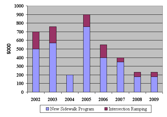
Historical Funding
Historically, the Pedestrian Programs (New Sidewalk Program and the Intersection Ramping Program) have received only modest funding which have declined considerably each year since 2005. For the years 2002 through 2009, the Pedestrian Programs funding allocations were $700,000, $760,000, $200,000 (Universal Program Review), $898,000, $619,000, $400,000, $230,000 and $230,000, respectively as illustrated in Figure 3:
Figure 3 –Historical Funding of Pedestrian Programs
It is important to note that the current Sidewalk Program is not fundamentally designed, nor sufficiently funded, as a means to affect implementation of new pedestrian infrastructure beyond the scope of addressing minor deficiencies to the existing network. Therefore, given the limited budget, higher priced high-priority sidewalk projects have been deferred as individual project costs exceeded the total funding envelope.
Implementation
Costs
The base pedestrian network (Schedules 1–17) represents an estimated $70M in outstanding pedestrian infrastructure need, which average to about $3.35M per year over the planning period to 2031. This estimate doesn’t include large-scale pedestrian infrastructure projects such as multi-use pathways in transit corridors and structures for crossing significant barriers such as the Canal, rivers or arterial roadways.
An additional $30M has been estimated to be required to implement multi-use connections to Baseline Station (crossing Woodroffe Avenue), Train Station (crossing Hwy 417), South Keys Station (crossing Sawmill Creek/Airport Parkway) and Midtown Bridge (crossing the Rideau Canal).
The City's 2009 capital budget forecast identified a total of $1.377M for new sidewalk/pathway program between 2010 and 2018 ($180k in 2010, $1,197M in 2011 and nothing between 2012 and 2018). This illustrates the substantial funding gap in the ability to pay for the required pedestrian infrastructure.
Providing sufficient funding, on an annual basis, to support the implementation of pedestrian facilities, that have not previously been possible from within the modest funding allocations received historically, will further Council's vision and contribute to closing the gap in sidewalk infrastructure that has been warranted and unfunded.
This report recommends that Council direct staff to put forward, starting 2010, a request of $3.5M per year for the pedestrian programs as shown in Table 3, and include the other major pedestrian crossings in the capital budget forecast based on available funding envelope.
Table 3 –
Proposed Annual Pedestrian Expenditures:
|
Type |
Annual Budget |
|
Sidewalk/Pathway Program |
$3,350,000 |
|
Pedestrian Facility Planning |
$100,000 |
|
Education and Promotion (component of TDM) |
$50,000 |
|
Total Capital Funding |
$3,500,000 |
* Estimates don’t include $30M for major connections to transit stations and over the Rideau Canal
It has to be noted that a funding request of about $9.6M, to support provision of pedestrian and cycling infrastructure has been put forward to the Federal Government under the Stimulus Fund.
RURAL
IMPLICATIONS
The policies and practices established in the draft Ottawa Pedestrian Plan are intended to apply equally to rural, suburban and urban areas of the City. In producing the proposed base pedestrian network, the pathways envisioned in the Rural Pathways Plan were taken into consideration.
The recommendations of the draft Ottawa Pedestrian Plan respond to nine Priority objectives outlined in the Council approved City Strategic Plan (2007-2010) including:
· Transportation Priority: Objective 1 – “Improve the City’s transportation network to afford ease of mobility, keep pace with growth, reduce congestion and work towards modal split targets.”
· Infrastructure Renewal Priority: Objective 2 – “By 2017, close the infrastructure renewal gap in sidewalks, traffic control signals, traffic signs and streetlights.”
· Solid Waste and Environmental Priority: Objective 3 – “Require walking, transit and cycling oriented communities and employment centres;” Objective 9 – “Ensure public health programs that work to promote health and prevent disease are maintained in concert with the growing population of the city;’ Objective 11 – “By 2010 close the gap in sidewalk, traffic lights, street lights and bicycle lane infrastructure that has been warranted and unfunded.”
· Transit Priority: Objective 1 – “Achieve a 30% modal split (for transit) by 2021.”
· Planning and Growth Management Priority: Objective 2 – “Respect the existing urban fabric neighbourhood form and the limits of existing hard services, so that new growth is integrated seamlessly with established neighbourhoods;” Objective 4 – “Ensure that City Infrastructure required for new growth is built or improved as needed to serve the growth.”
With the approval of the draft Ottawa Pedestrian Plan, the City will formally establish as City policy the framework for developing an Ottawa with practices that support and strengthen pedestrianism.
CONSULTATION
An extensive consultation process was undertaken to provide opportunity for residents, community representative, and professionals to provide input into the Pedestrian Plan Study, the strategies for changing travel behaviour to increase walking in Ottawa and solutions for making the walking network more attractive and efficient. The outcomes of this extensive public consultation process are presented in Chapter 5 of the draft Ottawa Pedestrian Plan.
The consultation process involved a series of events designed to gain insight into the pedestrian perspective and discuss the key principles and themes for making Ottawa a more pedestrian friendly City:
- Visioning Workshops
- Opportunities Workshops
- Public Open Houses
- A Pedestrian Survey
- Presentations of staff
- Presentations to Public Advisory Committees
Public
Advisory Committee
For the purposes of the Pedestrian Plan Study, with the assistance of Members of Council, a special Public Advisory Committee (PAC) was formed comprising balanced resident representation from urban, suburban and rural wards. Representatives from the Pedestrian and Transit Advisory Committee, the Accessibility Advisory Committee, the Rural Affairs Advisory Committee, the Federation of Community Associations, local school councils and walking clubs were recruited to participate on the PAC. The PAC assisted in the development of the Terms of Reference for the study, and participated in the Visioning and Opportunities Workshops providing valuable input at key stages as the Pedestrian Plan Study progressed.
Technical
Advisory Committee
In concert with the PAC, a Technical Advisory Committee (TAC) was established to draw on the expertise of civic professionals in planning, urban design, engineering, maintenance, recreation, health, transit, transportation and operations. Representatives from the various City Branches provided technical expertise as well as a valuable business perspective and service delivery insight.
Visioning
Workshops
In support of the development of the draft Ottawa Pedestrian Plan, Visioning Workshops engaged members of the project PAC and TAC to develop major principles and themes to give direction for key actions and strategies for making Ottawa more pedestrian friendly. Key principles and themes emerging from the Visioning Workshops were expressed in five primary categories:
1. Social Marketing.
2. Urban Design and Land Use Management.
3. Network Connectivity.
4. Targeted Implementation.
5. Institutional Strengthening.
Opportunities
Workshops
In further support of the Pedestrian Plan Study, members of the project PAC and TAC were engaged in Network Development Approach exercises at an Opportunities Workshop. Participants considered and discussed network accessibility, design, location, connectivity, historical development patterns and other attributes of walkability to identify challenges and barriers and to identify and evaluate potential network opportunities.
Pedestrian
Plan Survey
A primary component of the broader public consultation process for the Pedestrian Plan Study was the Pedestrian Plan Survey that was available at Ottawa.ca and distributed to residents at the first three public open houses. A total of 107 surveys were submitted, and varied in their degree of completion. A summary of the results is presented in the Appendixes of the draft Ottawa Pedestrian Plan. The survey, while not intended to be statistically valid, it provides a means to better understand the public’s reaction to walkability of Ottawa. The information collected through the Pedestrian Plan Survey was consistent with the information collected through the Visioning and Opportunities Workshops as well as the Open Houses and accordingly influenced the recommendations is the draft Ottawa Pedestrian Plan. Overwhelmingly, survey respondents agreed that walking was a more desirable mode of transportation than vehicular travel, although residents were equally divided as to whether or not Ottawa was a walkable city.
Public Open Houses
Another primary component of the broader public consultation process for the Pedestrian Plan Study, three public open houses (central, east, west) were hosted to introduce the study and later to provide members of the public an opportunity to comment on the key emerging principles and themes and to discuss network planning opportunities:
1. November 28, 2006 – Ottawa City Hall, 110 Laurier.
2. May 2, 2007 – Sir Wilfred Laurier High School, 1515 Tenth Line Road.
3. May 29, 2007 – Holy Trinity High School, 180 Katimavik Road.
The open houses were interactive in nature involving “opinion panels” and map exercises to solicit resident’s opinions on what makes places attractive for walking and what needs to be implemented to get more people walking more often. Approximately 100 residents attended the public open houses and overall were favourable of the City’s goal to improve walking and develop pedestrian-supportive policy. The ideas expressed and comments received were integrated into the development of the draft Ottawa Pedestrian Plan.
A final public open house to present the draft Ottawa Pedestrian Plan for public comment was hosted on March 3, 2009, Ottawa city Hall, 110 Laurier. A summary of the comments received is provided in Document 6 of this report. Full details of the results of the public open houses are presented in the Appendixes of the draft Ottawa Pedestrian Plan.
It
has to be noted that based on comments received during the final consultation
phase, several amendments will be undertaken to Schedules 1 to 17.
Proposed changes are included in Document 7.
Pedestrian and
Transit Advisory Committee (PTAC)
As stated earlier in this report, PTAC was represented during the Pedestrian Plan Study with no less than three members of PTAC participating on the PAC. In addition to this participatory approach during the Pedestrian Plan Study, PTAC were provided with periodic updates and presentations:
- February 23, 2006 (Update by staff)
- June 15, 2006 (Presentation by staff)
- October 19, 2006 (Update by PAC Members)
- April 19, 2007 (Presentation by staff)
- November 20, 2008 (Presentation by staff)
- December 2, 2008 (Meeting with PTAC PAC Members)
- February 19, 2009 (Presentation by staff)
At their meeting of 16 April 200, PTAC unanimously approved the following motion:
That PTAC
support the implementation of the OPP.
Additional
Consultation
To ensure greater
integration of the planning processes, presentations were provided for the
development community (staff and developers) through the Planning Sub-Committee
on May 22, 2009 and the Engineering Liaison Sub-Committee on May 29, 2009. Reception to the draft Ottawa Pedestrian
Plan was generally positive.
LEGAL/RISK MANAGEMENT IMPLICATIONS
There are no
legal or risk management impediments to the implementation of this report’s
recommendations, and their adoption will limit the City’s potential exposure to
claims arising from the public’s use of City sidewalks and pathways.
FINANCIAL IMPLICATIONS
This report recommends that staff be directed to put
forward, for Council consideration as part of the 2010 Capital Budget
deliberations, an annual capital request of $3.5M to support implementation of
the key outcomes of the Pedestrian Plan.
As presented in the 2009 Capital Budget, the 2010 and 2011
forecasts for Strategic Initiatives include projects that total $70M in each
year. The recommended Strategic Initiative projects were based on Council's
stated term priorities. Within this category, funding of $0.180M in 2010 and
$1.197M in 2011 was identified for the Sidewalk/Pathway Links Program. This
request will be reviewed within the overall Strategic Initiative funding
envelope.
Should Committee and Council approve report Recommendation 2,
the $3.5M and the associated operating budget impact of approximately $47K will
be identified for Council consideration within the Strategic Initiative
category of the 2010 Draft Capital Budget.
SUPPORTING DOCUMENTATION
Document 1 – Draft Ottawa Pedestrian Plan (on file with the City Clerk)
Document 2 – Draft Ottawa Pedestrian Plan Recommendations
Document 3 – Pedestrian Improvement Process Methodology
Document 4 – Rating System for New Sidewalk Requests
Document 5 – Maps of proposed Pedestrian Improvement Process Pilot Areas
Document 6 – Summary of Public Consultation Comments on the draft Plan
Document 7 – Amendments to the Base Pedestrian Network (Schedules 1-17)
DISPOSITION
· Pending the approval of the draft Ottawa Pedestrian Plan, staff will finalize the Plan to incorporate any changes made by Committee and Council.
· Staff will administer the Sidewalk Program utilizing the new Rating System for Sidewalk and Pathway Requests (Document 4)
· Staff will proceed with a responsive implementation of new sidewalks utilizing the Pedestrian Improvement Process (Document 3) commencing with a pilot to test and further refine the methodologies and define the process.
· City Operations staff will review and refer to the Pathway Winter Maintenance Criteria for determining pathways to receive winter maintenance.
· Staff will put forward, for Council consideration as part of the Budget deliberations, a request for an annual funding of $3.5 Million for the Pedestrian Programs.
DRAFT
OTTAWA PEDESTRIAN PLAN RECOMMENDATIONS DOCUMENT 2
Chapter 7.0 – The Base pedestrian network
|
Rec # |
It is recommended that
(the City): |
|
7.1 |
Form
an interdepartmental working group comprised of staff involved in planning,
design, maintenance and rehabilitation of sidewalks and pathways, to
coordinate efforts in pedestrian network management |
|
7.2 |
Use
walking participation results from the 2005 Origin Destination Survey, and
future updates to this survey as a source indicator of possible trends. |
|
7.3 |
Undertake
a comprehensive review of roles and responsibilities for all aspects of
sidewalk and pathway planning design, operation, rehabilitation and
maintenance to ensure that responsibility for all aspects of the pedestrian
network infrastructure have been accounted for and properly assigned to the
appropriate Branch or Department. |
|
7.4 |
The
scope and budget for new and reconstructed roads include the provision of
sidewalks and/or multi-use pathways as prescribed by the Pedestrian Plan, the
Official Plan and the Transportation Master Plan |
|
7.5 |
Modify
the New Sidewalk Links program using the criteria and weighting system for
assessing candidates identified in the Ottawa Pedestrian Plan, so that
eligibility is established and a clearer separation of priorities is
achieved. This may include recommendations for the development or
reinstatement of parallel program(s) for pedestrian facilities, other than
sidewalks such as pathways. |
|
7.6 |
Consolidate
pedestrian master data, currently managed independently by various branches,
utilizing the corporate GIS tool. This would require processes to ensure data
is continually updated and refined by the various data "owners" |
|
7.7 |
Refine
and adopt the Pedestrian Improvement Plan methodology and process to assess
the walkability of a community, subdivision or specific site. This
methodology proactively improves pedestrian facilities by analysing
pedestrian origins, routes and attractions. |
|
7.8 |
Establish
a Pedestrian Network for Ottawa based on: |
|
7.9 |
Launch
the Ottawa Pedestrian Plan by selecting a community for a pilot Pedestrian
Improvement Plan (Note: referred to in this report as the Pedestrian
Improvement Process) from one of the priority communities identified in
Figure 7.7 of this Plan. Establish an appropriate study budget and review and
report on the outcomes of the pilot including any recommendations and future
capital funding allocation request. |
Chapter 8.0 Planning and Design
|
Rec # |
It is recommended that
(the City): |
|
8.1 |
Develop
a Pedestrian Charter, for adoption by the City, that represents a commitment
to creating a walkable and pedestrian friendly-city. Link the Pedestrian
Charter to the City of Ottawa Official Plan and Transportation Master Plan |
|
8.2 |
Integrate
pedestrian planning tools and methods, from the Ottawa Pedestrian Plan, into
planning processes (such as the Community Design Plan process). These tools also include walkability
audits and the various pedestrian supportive guidelines. |
|
8.3 |
Establish
a priority list of landscape and streetscape improvements within each
Secondary Plan and Community Design Plans to further walkability. |
|
8.4 |
Create
a Pedestrian Facility Planning and Design Guideline document to be used
during the development review and capital works processes. Base the
guidelines on a consolidation of the pedestrian-supportive recommendations in
existing City guideline documents, as well as the safety and accessibility
guidelines presented in the Ottawa Pedestrian Plan. |
|
8.5 |
Require
the pedestrian design solutions established by the pedestrian plan be applied
to the development application process.
(Reference Recommendations 8.1, 8.3, 8.4, 8.5) |
|
8.6 |
Amend
the Traffic Impact Assessment Guidelines to specifically include the
requirement for a description of how the site meets the pedestrian supportive
guidelines and Pedestrian Improvement Plan methodologies (Reference
recommendation 8.5). |
|
8.7 |
Use
the sidewalk and boulevard guidelines presented in Table 8.4 as a guide for
the development or redevelopment of roadways. |
|
8.8 |
On
new road construction, road reconstruction and rehabilitation, apply Ottawa's
Pedestrian Guidelines and the Pedestrian Improvement Plan methodology, as
feasible. |
|
8.9 |
The
defined sidewalk pedestrian zone meet accessibility guidelines and remain
unimpeded. |
Chapter 9.0 Safety and Accessibility
|
Rec # |
It is recommended that
(the City): |
|
9.1 |
Review
design elements of sidewalks and street crossings to ensure that they meet
accessibility and safety guidelines presented in the Pedestrian Plan |
|
9.2 |
Review
warrants for ladder markings at pedestrian crossings for their application at
locations such as school crossings, roundabouts (particularly multi-lane) and
multiple right-turn and left-turn lanes. |
|
9.3 |
Improve
measures to reduce risks and improve accessibility for pedestrians passing
through road construction zones including advance signing for construction
activities, temporary conditions that are fully accessible and pedestrian
specific detours where appropriate |
Chapter 10.0 Maintenance and Rehabilitation
|
Rec # |
It is recommended that
(the City): |
|
10.1 |
Review
road and sidewalk maintenance standards, as an initiative under the City
Strategic Plan, with a specific focus on levels of service and maintenance
classifications based on the sidewalk's transportation role |
|
10.2 |
Support
programs, with the assistance of partners, such as the Yellow Grit Box
Program and the Snow-Go Program including the development and introduction of
new programs to meet specific needs. |
|
10.3 |
Undertake
a comprehensive review of roles and responsibilities for managing the
lifecycle continuum (planning, construction, maintenance, rehabilitation,
reconstruction and lighting) of pathways to ensure that responsibility for
all aspects of the pedestrian network infrastructure have been accounted for
and properly assigned to the appropriate Branch or Department. (Reference
recommendation 7.1 and 7.3) |
|
10.4 |
Adopt
the pathway winter maintenance criteria presented in Table 10.4. |
Chapter 11.0 Education and Promotion
|
Rec # |
It is recommended that
(the City): |
|
11.1 |
Develop
and implement pedestrian education and promotion programs under the TDM
Program and undertake a review of existing walking promotions to ensure a
coordinated approach. (Reference recommendations 7.1, 7.3 and 10.4.) |
PEDESTRIAN
IMPROVEMENT PROCESS DOCUMENT 3
The draft Ottawa Pedestrian Plan proposes the preliminary framework of the Pedestrian Improvement Process (entitled Pedestrian Improvement Plan in the draft Ottawa Pedestrian Plan) to review the pedestrian network and determine the pedestrian facilities that will be necessary or desirable in any given community to support the walking transportation mode and accommodate the needs of pedestrians of all ages and abilities.
Based on a logical analysis of pedestrian origins, routes and destinations/attractions, examining the relationship between route and neighbouring land use, and understanding the needs of the user groups, the review is intended to be applied equally to both existing and planned neighbourhoods and developments. The preliminary framework includes analysis of the following decisive factors:
- Existing and proposed pedestrian facilities (sidewalks, pathways, crosswalks, etc)
- Existing and proposed land use
- Barriers
- Transit; Natural features
- Development patterns
- Amenities/attraction
- Target users (adults, children)
It is important to note that such analysis must also take into consideration service targets established in other City policies such as the requirement for providing transit service and greenspace within 400m of residential land uses as established in the Transit Service and Fare Policy and the Official Plan, respectively.
In order to maximize the walkability of a community, the vision is to create a pedestrian network that captures every household (in residential areas) within a maximum distance of the attractor, and also captures as many households as possible within a minimum desirable walking distance. Unlike vehicular traffic plans, in the Pedestrian Improvement Process there is little need to quantify the number of pedestrian projected to use a facility as the planning framework is intended to determine where facilities should be placed rather than the facility capacity. Pedestrian facility capacity is addressed through design standard and performance measures for Pedestrian Levels of Service. Fundamentally, the Pedestrian Improvement Process is responding to whether or not to provide a facility rather than how many the facility should accommodate.
The result of a Pedestrian Improvement Process analysis will be the creation of a pedestrian routing and catchment area plan illustrating the existing and proposed primary pedestrian routes, attractions, and the number of households within walking range of the attraction(s). In the event that such a plan is significant in nature or encompasses a large geographic area with considerable budget implications to implement, it will be reviewed with the Ward Councillor and may be subject to public consultation in finalizing the community-based pedestrian improvement plan with a funding and implementation strategy.
RATING SYSTEM FOR NEW SIDEWALK REQUESTS DOCUMENT 4
The recommended criteria for determining sidewalk and pathway eligibility for consideration as a candidate under the New Sidewalks and Sidewalk/Pathways Links Program:
1. The requested sidewalk or pathway is situated on City of Ottawa property or if non-city owned, a legal agreement exists between the property owner and the City.
and
2.
(a) The requested sidewalk or pathway is necessary to complete a discontinuous section in an existing sidewalk or pathway.
or
(b) The requested sidewalk or pathway extends from the existing sidewalk or pathway network along city property toward an established public pedestrian destination;
and
3. The requested sidewalk or pathway does not constitute an isolated segment disconnected from the existing sidewalk or pathway network.
and
4. The requested sidewalk or pathway does not create an alternate route to an existing City-maintained sidewalk or pathway (400 metre threshold).
and
5. The requested sidewalk or pathway is not situated in a developing area whereby the infrastructure will be implemented through the development process.
and
6. The requested sidewalk or pathway is not situated in an area subject to road construction or reconstruction whereby the infrastructure will be implement through the construction process (TMP Phase 1 – 2009-2015/ISB Capital Works Program).
and
7. There exists the infrastructure or geometric configuration necessary to support implementation of the requested sidewalk or pathway.
Sidewalks and pathways that will not be eligible for consideration as a candidate under the New Sidewalks and Sidewalk/Pathways Links Program:
1) Sidewalks and pathways required through growth that represent missed opportunities whereby the methodologies of the Pedestrian Improvement Process as established by the Draft Ottawa Pedestrian Plan have not been applied to the development process.
The recommended criteria for determining priority ranking of sidewalks and pathways under the New Sidewalks and Sidewalk/Pathways Links Program:
Pedestrian Destinations/Generators
|
Criteria |
Weighting |
|
1. Rapid Transit (transitway 400m) |
10 |
|
2. Transit Route (bus route 400m) |
7 |
|
3. Primary and Intermediate School |
10 |
|
4. Secondary High School |
7 |
|
5. University |
7 |
|
6. Registered Daycare Facility |
5 |
|
7. Park (including greenspace) (400m) |
7 |
|
8. Adult School |
2 |
|
8. Community Centre |
5 |
|
9. Library |
5 |
|
10. Seniors’ Residence or Centre |
5 |
|
11. Long Term Care (Nursing Home) |
5 |
|
12. Impaired Persons |
5 |
|
13. Retail/Commercial Centres |
5 |
|
14. Business/Industrial Areas |
5 |
|
15. Employment Centres |
5 |
|
16. Church |
2 |
|
17. Other public institution |
2 |
|
|
|
Traffic and Roadway Characteristics
|
Criteria |
Weighting |
|
1. Posted Speed > 80 kph |
4 |
|
2. Posted Speed 50-70 kph |
2 |
|
3. Posted Speed > 40 kph |
0 |
|
4. Peak Hour Traffic Volume > 500 |
4 |
|
5. Peak Hour Traffic Volume 250-500 |
3 |
|
6. Peak Hour Traffic Volume 100-250 |
2 |
|
7. Peak Hour Traffic Volume > 50-100 |
1 |
|
8. Peak Traffic Volume < 50 |
0 |
|
9. Curvilinear Geometry |
2 |
|
10. Linear Geometry |
0 |
|
11. 2 lane |
0 |
|
12. 4 lane divided (>6m median) |
2 |
|
13. 4+ lanes undivided (<6m median) |
5 |
|
14. Significant Grade (+6%) |
2 |
|
15. Sightline Challenges (6 metres) |
2 |
|
16. Arterial Road Classification |
5 |
|
17. Collector Road Classification |
5 |
|
18. Identified Link (OP, TMP, or other City Policy) |
5 |
Adjacent Land Use
|
Criteria |
Weighting |
|
1. High Density Residential |
4 |
|
2. Medium Density Residential |
3 |
|
3. Low Density Residential |
2 |
|
4. Commercial |
4 |
|
5. Business/Industrial Areas |
4 |
|
6. Employment Centres |
4 |
|
|
|
General Considerations
|
Criteria |
Weighting |
|
1. Desire Lines (beaten path) |
5 |
|
2. No Existing Parallel Pedestrian Facility |
3 |
|
3. Crosses significant barrier (reasonable application) |
5 |
|
4. Primary Connector (Dead-end, Cul-de-sacs, local streets) |
5 |
|
5. Years on Candidate List (per year) |
1 |
|
6. Other Relevant Factors |
1-5 |
Recommended
Areas for a Pilot Pedestrian
Improvement
Process DOCUMENT 5
Urban Area 1
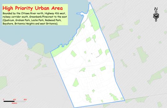
Urban Area 2
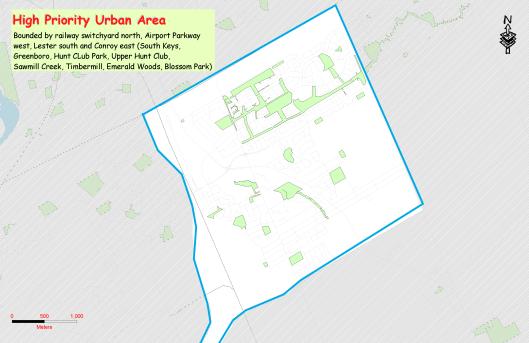
Rural Area
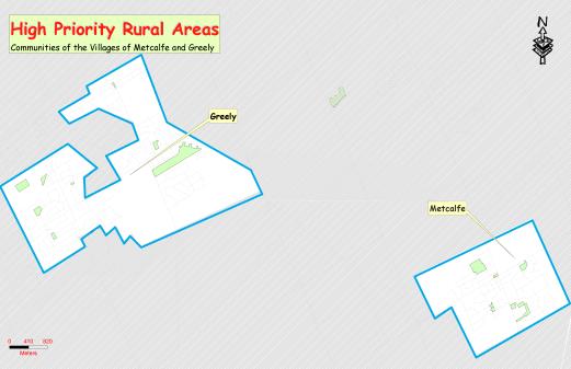
Summary of
PUBLIC CONSULTATION COMMENTS on the
draft
Pedestrian Plan DOCUMENT 6
The
following table summarizes comments on the Draft Ottawa Pedestrian Plan
received from residents at the final public open house
to present the draft Ottawa Pedestrian Plan for public comment, March 3, 2009,
Ottawa city Hall, 110 Laurier:
|
Comment |
Response |
|
I support the
plan in principle. I specifically
support the pedestrian bridge over the canal between Glebe and Old Ottawa
East. Also, the pathways along the Rideau River in Old Ottawa East and Old
Ottawa South. |
Noted |
|
Need more
pedestrian crossing points on Queen Elizabeth Dr and Colonel By Dr. |
The Pedestrian
Improvement Process will give stakeholders an opportunity to translate ideas
for their respective neighbourhoods into recommendations for concrete action
plans. Please note, this is NCC
jurisdiction. |
|
Glad to see the
Pedestrian Path crossing canal at Fifth. Also, opening sidewalks along Rideau
River through Old Ottawa South and Old Ottawa East |
Included in the
proposed base pedestrian network. |
|
Can we get
individual area maps to study? It will take a lot of time to extrapolate what's
relevant to our community. |
Individual area
maps can be found in the draft Ottawa Pedestrian Plan, available on
Ottawa.ca. |
|
The plan is as
much as I expected, having participated in The Public Advisory Committee. |
Comment
submitted by member of Public Advisory Committee. |
|
I wonder if we
need a super-short point list boiled down from the executive summary. This
might be needed to attract the attention of journalists and politicians. |
Several
PowerPoint presentations containing a summarized version of the Executive
Summary were produced for presentation to councillors, assistants and
committees |
|
Pleased to see
the pedestrian bridge at Clegg and Fifth. |
Included in the
proposed base pedestrian network. |
|
Inclusion of
pedestrian bridge in plan at Clegg and Fifth across the canal is an important
component for taking pressure off Pretoria Bridge traffic :) |
Included in the
proposed base pedestrian network. |
|
The World Health
Organization has recommended that walkable cities are an important element to
improving health and decreasing incidence of cardiovascular disease (or
something like that) worldwide. |
Along with
several other health benefits. See section 4.1.1 of the Draft Pedestrian Plan
- Improving Citizens’ Health. |
|
Main Street in
Ottawa East is, as you have identified, a dangerous street for walking. Cars
speeding through traffic lights at Main and Clegg (with or sometimes even
against the light) are quite common. Also, pedestrians crossing across Main
St at this point takes too long once you have pushed the button to walk. |
Section 9.3.3
re: Intersection Crossings of the Draft Pedestrian Plan speaks about
implementing intersection design elements that benefit pedestrians, including
shortening pedestrian crossing distances and wait times and increasing
pedestrian and vehicle visibility at intersections. |
|
Thanks for the
great Open House! |
Thank you for
attending. |
|
Great that such
emphasis is being placed on better routes for pedestrians. |
Thank you for
attending the Draft Ottawa Pedestrian Plan public open house and thank you to
for your positive comments regarding the draft plan. |
|
Also along
Rideau River, between Smyth and the Queensway (west side) the Ottawa East
community is working hard towards a soft surfaced, nature-friendly trail - it
will be great for pedestrians |
Noted. |
|
Is the schedule
(#2) and accompanying page of comments/rec's that shows the potential new
canal link on the web? I couldn't find it - only a list of appendices etc … |
All the
schedules (maps) and tables available at ottawa.ca, and can be found in Chapter
7 of the draft Plan. |
|
Nice plan -- now
let's actually follow through |
Noted. |
|
Fifth and Echo
pedestrian bridge should be a top priority. |
Noted. |
|
9.3.15
Underpasses for pedestrians are a crime haven - Dupont Circle in Washington
and underpasses in front of Chateau Laurier. |
See section
8.1.1.6 of the Draft Pedestrian Plan – Less Crime and Fear of Crime. |
|
9.3.15 Elevated
pedestrian crossovers will be very cold and bitter in winter unless enclosed
which then maybe there is a crime haven (like the Rideau Street crossover
from Rideau Centre) |
The City of
Ottawa’s Transit-Oriented Guidelines specifically makes reference to the
grade separated pedestrian connection at the Rideau Centre as an example
where the Crime Prevention Through Environmental Design (CPTED) principles
have been applied. CPTED recommends providing amenities and services within
grade-separated linkages to generate activities and enhance security. Public
telephones, benches, automated banking machines, news stands, retail kiosks,
promotional marking activities and public art programs should be considered. |
|
Can cyclists and
pedestrians be separated on the sidewalk? As traffic density increases
cyclists are more prone to use the sidewalk to the detriment of pedestrians |
It is illegal to
cycle on a sidewalk. Creating a separation would imply that it's ok to cycle
on the sidewalk. |
|
10.4.1.1 What
about the first 10 feet or so of sidewalks on a private lot that is actually
city-owned? Who cleans that? I.e. the sidewalk from the street to the water gate,
which is at the actual lot line. |
See Section
10.4.1.1 re: Property Maintenance By-law (2005-208). “Snow and ice
removal on private property is regulated under the Property Maintenance
By-law No. 2005-208 whereby owners/occupants are responsible for the removal
of snow and ice from all walkways on their own property and on roofs of
buildings that may cause a safety hazard.” |
|
What can be done
about ice that forms at night on sidewalks from daily melt runoff in the
early spring? If there is a dusting of snow of it, it cannot be seen and is a
real hazard for pedestrians. |
Section 10.2 of
the Draft Pedestrian Plan identifies key challenges that face Surface
Operations in their efforts to maintain Ottawa’s sidewalks and pathways. One
of the main challenges is dealing with extreme weather fluctuations,
freeze-thaw cycles and freezing rain and it’s effects on both winter
maintenance and infrastructure lifespan. |
|
How about the
banks of snow left by street plows at the end of each block? This forces
pedestrians to walk on the street with vehicular traffic even though the
sidewalks have been cleared. |
“Plow operators
try as best as possible to equally distribute the snow by plowing the snow
away from corner driveway entrances. A street corner typically receives more snow
on the side and front yard as two roadways meet generating more snow in a
limited area.” -
http://www.ottawa.ca |
|
Increased
traffic density makes crossing busy streets where there is no traffic light
very difficult. Can the traffic light timing along a street be setup so that
there are breaks in the traffic that allows pedestrian to cross? It's needed
on Parkdale between 15:45 and 17:30. |
See section 9.3
re: Pedestrian Street Crossings – “Pedestrians must be able to cross
streets at regular intervals and should not be expected to go out of their
way more than is necessary in order to take advantage of crossing locations.
As a general rule, a diversion to reach a good street crossing location
should not exceed approximately 100m.” |
|
Too many
sidewalks and bus stops are not properly cleared of snow. The north side of
Hunt Club rd east at Riverside is one example. |
Noted. See
section 10.4 re: Winter Sidewalk Maintenance. |
|
It appears that
some newly created sidewalks have cross-slopes that exceed 2%. The "new"
sidewalk on the south side of Carling between Viscount and Anna is a possible
section that appears to exceed cross-slope grades. |
Sec 9.2.1 re: Sidewalks
- "A sidewalk with a steep cross slope can be modified to provide a
level area 0.9m wide within the width of the sidewalk, or the height of the
curb can be increased but with potential impacts to on-street parking and
curb-ramp designs." |
|
The
Queensway-Carling interchange is a dangerous place for pedestrians. People
have to walk across 2 off-ramps and one on-ramp in that area. This is
especially dangerous for senior citizens. |
City of Ottawa
Traffic Assessment Technologists are aware of the problem and have
investigated possible solutions. However, this location was deemed MTO
jurisdiction. |
|
I don't like Traffic
circles since priority is for cars, not people. |
Section 9.3.14
of the Draft Pedestrian Plan re: Roundabouts – This section lists
several features that facilitate the pedestrian crossing with roundabouts and
traffic circles. |
|
The Corktown
Bridge at Somerset St has been such a success. I support any proposal for
additional pedestrian/cycling bridges over the canal. In addition, taking a
further step and placing a footbridge over the Ottawa River (Somerset
E/Donald) would link Vanier amazingly!! |
Noted. As stated
in the Draft Pedestrian Plan, the Pedestrian Improvement Plan will give
stakeholders an opportunity to translate ideas for their respective
neighbourhoods into recommendations for concrete action plans. |
|
The proposed
pathways along the Ottawa River are all strong components of this plan for
residents and visitors alike. |
Noted |
|
As I take
transit when venturing further afield, I am in favour of establishing links
between existing sidewalks and ensuring pedestrian access to transit. All too
often, traffic patterns/lack of sidewalks/long separation between crossing
points make transit access undesirable or risky. |
The
Transportation Master Plan makes reference to transit access in Section 5.2
re: Sidewalks and Pedestrian Crossings – “The City will... (1) On new
roads, and on reconstructed roads where feasible, require the provision of…
(d) Direct, high-quality pedestrian connections to rapid transit stations,
bus stops and other major walking destinations.” |
|
I very much
appreciate the proposed pedestrian crossing between Clegg and Fifth across
the canal. It will do wonders for
both neighbourhoods. |
Noted. |
|
Lower the speed
limits to 40Km's downtown to help pedestrians. |
See Section 9.0
of the Draft Pedestrian Plan re: Safety and Accessibility. |
|
Restaurant patios
and advertisements on storefronts are in the way of pedestrians on the
sidewalks. |
See Section
9.2.1 of the Draft Pedestrian Plan re: Sidewalks – “Protruding objects
into the sidewalk corridor” |
|
I recommend that
you guys read: A Pattern Language by Christopher Alexander |
Noted. |
|
I strongly
support the City of Ottawa's development of a Pedestrian Plan. The current
priorities for Transportation in Ottawa are: Cars, Buses, LRT, pedestrians
and lastly cyclists. Pedestrians and
cyclists are only given priority if car traffic and Bus traffic are not
significantly impacted. Adding additional sidewalks on high traffic local
streets (eg Fraser West end) and pedestrian overpasses (eg crossing the
Rideau River downtown) would certainly improve the walkability and liveability
of these areas. |
Thank you. The
Pedestrian Improvement Plan will give stakeholders an opportunity to
translate ideas for their respective neighbourhoods into recommendations for
concrete action plans. |
|
There are
important issues that this plan does not address: a) Walkablity to
destination: How long does it take to walk to stores, schools and high speed
transportation The walkability
of many Ottawa addresses is poor See: http://www.walkscore.com/. There are many natural and unnatural
barriers to walking in Ottawa (eg Queensway, Rideau river, Canal, Baseline,
Carling, Large parking lots etc), which make trips longer and unpleasant, and the trend in Ottawa
is to close local grocery stores and create large box stores and shopping
centers which increases the need for cars and discourages walking. The Book Car
free Cities by J H Crawford, International Books, 2002, provide standards for
walkable liveable Cities. The 2020 Plan
and Zoning does not take into account the walkability of City Streets and the
location of shops to be walkable |
Ottawa 20/20
Core Principle #5: A City of Distinct, Liveable Communities - "Ottawa's communities have a
variety of housing choices, employment, parks and a wide range of services
and facilities accessible by walking, cycling and transit." |
|
b) Liveability.
How pleasant is it to walk and live on a Street; Local Streets and Arterials
with high volumes of cars on not very liveable or walkable. People living in high volume density areas
with high traffic volumes on their streets need to live in high rises to get
away from the noise. This makes the streets less walkable and liveable I live downtown,
and while many places are quite walkable, most of the downtown streets not
very liveable. Reducing
downtown traffic volume and speed on local streets would be a way to improve
this. |
See Section 11.1
of the Draft Pedestrian Plan re: The Role of Education and Promotion -
"Education and encouragement programs are aimed at changing attitudes
and behaviour and making Ottawa's citizens think about including walking in
their everyday lives. By promoting walking, individuals and organizations
plant the seeds for initiating change by creating awareness about pedestrian
issues and alerting others to the benefits of walking and how walkable places
foster healthier, more liveable communities..." |
|
|
|
|
c) Cycling:
Currently most of Ottawa's (Including
NCC) cycling paths are shared pedestrian cycling paths, which endangers both
cyclists and pedestrians (Eg Bay
Southbound between Wellington and
Gloucester is a prime example). There are no plans in Ottawa's Cycling
plan for separated dedicated cycle lanes (For example of dedicated cycle
lanes, See: Downtown Montreal’s dedicated cycling lanes on De
Maisoneuve). As Pedestrian and cycle
traffic increases Ottawa will see more and more accidents which will
discourage both walking and cycling. Ottawa needs to have a cycling network
that separated cycle, car and pedestrian traffic. |
Cycling issues
are addressed in the Ottawa Cycling Plan.
The City and NCC pathways are designed to support both cycling and
pedestrian transportation. Rules of
etiquette govern user behaviours . |
|
Without
addressing the above issues Ottawa will remain "Autowa" - a
predominately car driven City, where the pedestrians get to watch the cars go
by. Ottawa needs to get serious in terms of investment in walkability, dense
urban design, and increased traffic control (speed, parking etc) in order for
pedestrian traffic to increase significantly |
See Section 1.0
of the Draft Pedestrian Plan re: Introduction - "The Ottawa
Pedestrian Plan is intended as a guide to establish Ottawa as one of the most
pedestrian active cities in North America by encouraging and facilitating
more people to walk more often." |
|
I appreciated
yesterday's Open House -- it was well presented and informative, so kudos to
you and the crew. Just wondering
whether you had an electronic copy of the documents (particularly for the
portions between Rideau Canal, Bank Street, Walkley, St. Laurent and the
Queensway). These are somewhat adjacent to our neighbourhood (Riverview Park) and it would be helpful
if I could share it with our Community Association Planning and Development
committee. |
Thank you for
attending and for your positive comments. All the schedules
(maps) and tables are on line at ottawa.ca, found in Chapter 7 of the draft
Plan. A link is attached for your
ease of reference. http://www.ottawa.ca/residents/public_consult/pedestrian/pedestrian_network_en.pdf |
|
Most of these
ideas stem from problems people experience with the push-button activated
pedestrian signals. Responsiveness
and reliability of the push buttons has been a relatively steady source of
complaint. Unlike being a car driver,
there is no licensing requirement to be a pedestrian and no opportunity to
impose an educational prerequisite before people of all ages and subject to
all rages of abilities or disabilities are allowed out to navigate sidewalks
and intersections. The onus should be
on simplicity of operation and the most basic or universal of human factors
common in the population. The push buttons inherently pose a challenge to the
disabled, to the young and the very old.
The variability of the response times confuses many into not knowing
if it is operating properly - this is particularly true when the timing is
long. One could argue using the
countless studies done in the social sciences on stimulus-response training
that any response time in excess of 30 to 40 seconds inherently fails to
re-enforce the desired behaviour. We are all hardwired to make cause and
affect linkages on shorter timing but not on longer timing because this is
fundamental human factor. These
suggestions are based on the fact that technology is more changeable and can
be adapted to human factors with greater success than the reverse. |
See Section
9.3.11 of the Draft Pedestrian Plan re: Intersection Pedestrian Signals. |
|
Can we minimize
the use of push-button activations to only absolutely necessary cases in the
future? |
See Section
9.3.11 of the Draft Pedestrian Plan re: Intersection Pedestrian Signals.
– “The City of Ottawa undertakes investigations of intersections and
mid-block sections to determine the need for pedestrian signals if the
minimum warrants are satisfied as defined in the Ontario Traffic Manual.” This comment has
been referred to the Traffic Operations Unit for their consideration. |
|
Are there
opportunities to reduce the number of push buttons currently in use? Do we need criteria for this? |
See Section
9.3.11 of the Draft Pedestrian Plan re: Intersection Pedestrian Signals.
– “The City of Ottawa undertakes investigations of intersections and
mid-block sections to determine the need for pedestrian signals if the
minimum warrants are satisfied as defined in the Ontario Traffic Manual.” This comment has
been referred to the Traffic Operations Unit for their consideration. |
|
Where pedestrian
activations are absolutely necessary, can we replace the push buttons with
motion sensors as is done at the Transit way crossing near Dominion
Station? Would motion sensors provide
added benefits of reduced maintenance and longer operating life before
failure (fewer moving parts and less physical abuse)? In other words, would motion sensors offer
a lower lifecycle cost opportunity in addition to being more pedestrian,
disability and age-ability friendly?
Motion sensors also work well for cyclists. |
The Pedestrian
Plan does not make reference to motion sensor activated crossings. This comment has
been referred to the Traffic Operations Unit for their consideration. |
|
Can the default
timing for responsiveness to ped activations be as short as possible by
default and only lengthened when absolutely necessary? |
This comment has
been referred to the Traffic Operations Unit for their consideration. |
|
Can countdown
timer displays show both the remaining walk time as well as the remaining
don't walk time? |
The Pedestrian
Plan only makes reference to the standard Pedestrian countdown signals in
which the countdown marks the length of time between the WALK signal and the
solid DON’T WALK signal. However, this
comment has been referred to the Traffic Operations Unit for their
consideration. |
|
Can we get more
pedestrian advance signals (like Elgin and Somerset) to enable pedestrians to
enter intersections ahead of cars? Have pedestrian "scramble" (AKA
- All Way Walk) cycles been considered in Ottawa as means of improving
pedestrian safety while giving more net time for car movements through
intersections? |
See Section
9.3.9 of Draft Pedestrian Plan re: Traffic Signal Phasing – “Where the volume
of pedestrians is so high that it blocks turning traffic during the entire
“GREEN” signal phase, an exclusive pedestrian phase can be introduced. During
this phase, all vehicles are stopped on all approaches to the intersection
either diagonally or conventionally.” |
|
Does the
Pedestrian Plan have recommendations to limit the width or widening of
intersections? |
There are no
recommendations in the Pedestrian Plan in regards to limiting the width or
widening of intersections. However, section
9.3.3 of the Pedestrian Plan does state: “Improvements to pedestrian
crossings at intersections can be achieved by introducing intersection design
elements that shorten pedestrian crossing distances…” Section 9.3.7
speaks about road narrowing, as part of Area Traffic Management, which can
improve the pedestrian environment and improve driver behaviour. Also, see
Section 9.3.8.1 re: Auxiliary Left and Right-Turn Lanes – “The
application of multi-right or left-turn lanes can further increase the pedestrian
crossing distance. However, signal phasing can be utilized to establish a
separate ‘protected’ pedestrian phase offering greater benefit to pedestrian
safety.” |
|
Is there a
policy to avoid channelized right hand turn lanes in the future and to remove
existing ones? |
Section 9.3.8:
"In looking for an alternative design for channelized right-turn lanes
that are more pedestrian friendly and support improved traffic operation the
city is currently piloting an Urban Smart Channel Concept…" |
|
As I mentioned yesterday,
the signals group have always been very conscientious about adjusting the
timing where possible in response to pedestrian complaints but the onus is on
the pedestrians to complain for change to be initiated. Car drivers don't need to complain, as the
default is to optimize the system for them.
Do we need to shift priorities or invert the defaults? We hear other cities have given pedestrian
infrastructure priority over other modes as part of the push to more
sustainable and lower cost transportation.
Prior to amalgamation the Region's TMP explicitly stated that priority
was to be given in the following order to the various modes: walking,
cycling, transit and the private automobile.
Is there merit using other cities or the previous Regional TMP as
examples of sustainable transport policy missing in our current TMP? |
The priority of
the Draft Pedestrian Plan is on pedestrians. This comment concerning the TMP
has been referred to the Transportation and Infrastructures Planning Division
for their consideration. |
|
For goodness
sake GET REAL. Adopting a Pedestrian First philosophy in developing this plan
is asking for failure. I am a pedestrian, I walk the streets regularly and I
wish drivers paid more heed to pedestrians. But I also note that drivers
don’t pay much heed to other drivers. So there is a need for much improved
driver education. On the other
hand vehicles will be with us for more than my lifetime and they also need to
be accommodated. What we don’t need is pitting pedestrians against vehicles.
Rather we need intelligent planning that takes into account the needs of
pedestrians, cyclists and drivers alike. Developing these plans in isolation
of each other only serves to develop independent constituencies (advocates
and bureaucrats) at odds with each other. Please get with
it, we need integrated planning, not that conducted in silos that never
connect. |
The Pedestrian
Plan does not pit drivers against pedestrians. Section 1.2 of the Pedestrian
Plan proposes a “pedestrian-first” philosophy, while incorporating cycling,
transit and vehicular movement opportunities. The City's
Integrated Road Safety Program (IRSP) is a partnership between the Ottawa
Police Service, the Department of Public Works and Services, Ottawa Public
Health and community partners. The program was established in 2003 and uses a
3 E approach to road safety (Engineering, Enforcement and Education). Reducing
speeding, educating young drivers and encouraging sharing of the road are
keystones of this program to decrease by 30 per cent, the number of people
killed or seriously injured on Ottawa's roads by 2010. |
AMENDMENTS TO THE BASE PEDESTRIAN NETWORK
(Schedules 1 to 17) DOCUMENT 7
General Changes:
- In legend, change “Existing Pedestrian Bridges” to Bridges with Pedestrian Facilities
- In the legend, make the symbols for Existing Audible Pedestrian Signals and Existing Signalized Intersections larger.
- Update schedules with current existing/proposed transit corridors.
- Refer to Carling-Bayview Community Design Plan for existing/proposed sidewalk, pathway and pedestrian bridge segments that will be amended to the overall map of the Draft Pedestrian Plan.
- Refer to Richmond/Westboro Community Design Plan for existing/proposed pathway segments that will be amended to the overall map of the Draft Pedestrian Plan.
- Refer to pending Wellington Community Design Plan for existing/proposed sidewalk segments that will be amended to the overall map of the Draft Pedestrian Plan.
- Refer to the Merivale Secondary Design Plan and the Baseline/Woodroffe Secondary Design Plan for existing/proposed pathway segments that will be amended to the overall map of the Draft Pedestrian Plan.
- Refer to East Urban Community Design Plan for existing/proposed sidewalk and pathway segments that will be amended to the overall map of the Draft Pedestrian Plan.
- Refer to Orléans Industrial Park Land Use and Design Study Community Design Plan for existing/proposed sidewalk and pathway segments that will be amended to the overall map of the Draft Pedestrian Plan.
- Refer to Mer Bleue Community Design Plan for amendments to the overall map of the Draft Pedestrian Plan.
- Refer to Fernbank Community Design Plan for existing/proposed sidewalk and pathway segments that will be amended to the overall map of the Draft Pedestrian Plan.
- Refer to North Gower Community Design Plan for
existing/proposed sidewalk and pathway segments that will be amended to
the overall map of the Draft Pedestrian Plan.
- Add proposed pathways from Manotick Secondary Plan.
- Refer to Carp Village Community Design Plan for existing/proposed sidewalk and pathway segments that will be amended to the overall map of the Draft Pedestrian Plan.
Schedule 1: Ottawa Centre
- Proposed new pathway (Escarpment Plan) will run north/south and connect Albert, Laurier and Slater.
Schedule 2: Ottawa Inner
·
Proposed pathway along the west side of the Rideau River
should be moved closer to the shoreline.
- Connect the proposed pathway along the Rideau River to Lees.
Schedule 3: Ottawa East
- Sidewalk is needed on both sides of Cyrville, between the transit station and Cummings.
- Sidewalk is needed on north side of Cyrville, from Cummings to Ogilvie.
- Sidewalk is now in place on north side Cyrville, between Ogilvie and St. Laurent (new development). Show as existing. There is a need for a sidewalk on the south side.
- Show the existing connection between Presland Rd W and the Vanier Parkway.
- Show the existing sidewalk along west side of Mayfield St.
- Show proposed Donald St to Somerset St East bridge over the Rideau River
- Reconsider sidewalk on Dunbarton.
Schedule 4: Beacon Hill
- Remove existing pathway segment north of Ogilvie, between Blair and Bathgate. This is CSIS property.
- Add proposed sidewalk on Shefford, between Loyola and Emard.
- Review requirements for sidewalk on Canotek (or a paved shoulder).
- Show easements for pedestrians at Telesat Court.
Schedule 6a: Merivale
- Show existing sidewalks, Midblock on Merivale, west of Burris, both sides.
- Show existing sidewalk on Walgate, extending to intersection of Charkay.
- Add proposed pedestrian connection on southeast corner of intersection of Baseline and Merivale.
Schedule 6b: Merivale
- Show existing sidewalk on Redpine, between Overlake and Saginaw, south side.
- Show existing sidewalk on Citiplace.
Schedule 7B: Alta Vista
- Small segment of an existing pathway along the Rideau River was shown as being owned by the NCC. Although the pathway is on NCC lands, it is not considered a formal pathway. It is only kept open because it provides access to the sewer outlets. (This path is not shown in the cycling plan)
- Pathway on former rail line is plowed by the City and is being used to access sewers at the Rideau River. (This path is not shown in the cycling plan)
- Show new alignment of pathway running through the Cancer Survivor’s Park.
- Show existing and proposed sidewalks in the Terminal Ave and Trainyards commercial redevelopment.
- Show existing sidewalk on Labrie between Cyrville and Comstock, west side.
- Show existing City of Ottawa pathway from Saxony Cres. to the rear property of Des Pins School.
- Remove school at 1837 Stonehenge Cres. (building has been demolished).
Schedule 8a: Hunt Club
- Show existing pedestrian pathway/easement Bowesville to Bowesville
- Show proposed sidewalk Bowesville N.
- Show proposed sidewalk Bowesville S.
- Show existing paved shoulder on Uplands, between Breadner and Research.
- Show existing pathway that runs off of Curtis.
- Add proposed pathway to complete the pathway that runs off Curtis.
Schedule 8b: Hunt Club
- Show existing pathway that connects with Lorry Greenberg.
- Show existing paved shoulders on Lester, west of Albion.
- Proposed sidewalks along Stedman St and Meandering Brook Dr to be shown as existing.
- Show three existing pathways that connect with Stedman St. and Meandering Brook Dr.
- Show existing sidewalks on Bank, south of Albion.
- Show two existing pathways that connect with Bank, south of Albion.
- Show existing sidewalk on Tapiola, south of Johnston (west intersection)
- Show proposed sidewalk on Tapiola, south of Johnston (east intersection)
- Show existing pathways across Somero.
Schedule 9B: Bayshore/Cedarview
- Three existing pathways shown along Richmond, south of Robertson, are on private property.
- Proposed sidewalk on Arnold to be shown as existing.
- Show existing pathway connection to the intersection of Baseline and John Sutherland.
- Remove existing sidewalk shown on Consul (does not have existing sidewalk).
- Remove existing sidewalk shown east of Ashley and north of Morrison (parking lot with no pedestrian connections).
- Show proposed sidewalk at Baseline and Monterey, line-up with the crosswalk.
- Show pathway connection between Baseline and Draffin.
- Proposed sidewalk on Ashgrove to be shown as existing.
- Proposed sidewalk off Hobart to be shown as existing.
- Show pathway segment north of Bateman.
- Add proposed pathway link between Hunt Club and the existing pathway that runs parallel to Skipton.
- Add proposed pathway link between Newhaven and the existing pathway that runs parallel to Hunt Club.
· Show Centrepointe sidewalks, both sides, entire length.
· Include any missing links along Craig Henry, both sides entire length.
· Extend pathway in the hydro corridor ending at the intersection of Craig Henry and Knoxdale should be on the north side of Knoxdale to the intersection of Knoxdale and Woodroffe.
· The proposed sidewalk extending from the end of Siskin to the intersection of Cedarview and Hunt Club to be shown as a multi-use pathway (not a sidewalk)
· Show proposed sidewalk on Hunt Club at the access to Siskin near Riverbrook.
· Show existing pathway Greenbank from Hunt Club to Bellman.
· Show existing pathway Woodroffe, west side, from Hunt Club to the proposed pathway just north of the railway (along transitway corridor)
Schedule 10a: Orleans
- Review pathways Duford to Tenth Line?
- Show proposed pedestrian link from Tenth Line to Tulip.
- Show pathway connection from Alpine to Champlain.
Schedule 10b: Orleans
- Change pathway along the Ottawa River east of Voyageur Park as City (not NCC).
- Review pathways Duford to Tenth Line?
- Major off-road east-west connection missing. See the Greenspace Master Plan. Part of Orléans-Cumberland-Rockland link. Segment here goes along tributary or Cardinal Creek to Bloomfield Estate (Jonquille Way) to Old Montreal Rd to existing path at Cumberland (Domaine des Gouverneur – east of Quigley Hill Rd) and into the village.
- Show proposed pedestrian link from Tenth Line to Tulip.
- Show pathway connection from Alpine to Champlain.
- Remove the two proposed sidewalks in forest area west of Thistleleaf.
- Show pedestrian connections to transit corridor and through rail line along Navan and Renaud.
- Proposed pathway near Boisfranc continues south along hydro corridor.
Schedule 11: South Gloucester/Leitrim
- Show missing segments of proposed/existing sidewalks and pathways from Community Design Plans – Riverside South.
Schedule 12b: Kanata/Stittsville
- Show missing segments of proposed/existing sidewalks and pathways from Community Design Plans (South Nepean Town Center CDP and Barrhaven South CDP) and new subdivisions.
- Area south of Jock River, between Jockvale and Greenbank is not mixed-use.
Schedule 14a: Rural East
(Sarsfield and Vars)
- Review connection from Vars to Sarsfield.
- Review need for sidewalk on Rockdale, between Frank Kenny and Devine and Devine, between Rockdale and Frank Kenny.
Schedule 14b: Rural East
(Cumberland, Navan and Notre-Dame-de-Champs)
- Review Rural Pathways Plan for existing/proposed sidewalk and pathway.
- Show proposed pedestrian connection from the Village core at the corner of Dunning Rd and Cameron St (Old Montreal Rd) east to the Cumberland Museum (the Village’s main attraction)
- Show proposed sidewalk on the west side of Dunning Rd from Brickland north to pathway crossing at the RJ Kennedy.
- Show proposed paved shoulders from the Village Core to Orleans along Montreal Rd..
- Remove school shown at Market and Dunning (has been closed).
- Show existing paved shoulders on Dunning Rd connecting to Sarsfield
- Show proposed pathway connection from Wilhaven to Quigley Hill (continuation of shown proposed pathway that ends at Wilhaven).
- Extend proposed pathway along Colonial, east of Rockdale extended south on Rockdale and west of Colonial.
- Extend proposed sidewalk on Colonial, west of Frank Kenny Rd, extended to intersection.
Schedule 15a: Rural Southeast
(Osgoode and Vernon)
- Official Plan shows a proposed collector road in Vernon Village. Show proposed pedestrian facilities in Pedestrian Plan?
Schedule 15b:
Rural Southeast (Greely and Metcalfe)
- Review Rural Pathways Plan for existing/proposed sidewalk and pathway.
- The proposed pathway running through a provincially significant wetland may not be feasible.