|
1. Downtown Ottawa Transit Tunnel (DOTT) Planning and
Environmental Study (Interim Report) – Corridor Alignment and Station
Alternatives
Étude de planification et
d’évaluation environnementale du tunnel de transport en commin au centre
ville d’Ottawa (TTCCVO) (Rapport Provisoire) –
Tracé du couloir et choiz des stations
|
committee recommendation as amended
That Council:
1. Approve the
recommended corridor alignment and station options for the Downtown Ottawa
Transit Tunnel (DOTT) Planning and Environmental Assessment Study.
2. Direct staff to release a Request
for Information (RFI) to property owners within and adjacent to the recommended
corridor alignment to solicit ideas on station access, development, design,
and other matters with the aim of improving ridership, ridership experience and lowering City costs.
3. Direct staff, in
consultation with the Ward Councillor, to investigate options with the goal to
minimize bus traffic along Albert Street as it passes through the LeBreton
Flats and report back to the Transit Committee.
4. Direct Transit
Services staff to develop for the approval of Committee and Council, a
conceptual transit plan for surface operations, and;
That the following principles be incorporated into the terms of
reference of the plan:
a. The recognition of the continued
importance of preserving the economic vitality and viability of the Rideau
commercial district.
b. The importance of transit service –
both access from all areas of the City and the details of operations – to support
this economic vitality and viability.
c. The need for convenient connections
from the surface transit service to the underground light rail line.
d. The need for continued transit
service on Mackenzie King Bridge to maintain a pedestrian flow through the
Rideau Centre and nearby businesses and to maximize existing infrastructure
investment.
e. The need for substantial reductions
in the number of buses operating on Rideau Street and on Albert and Slater
Streets to improve the general environment on those streets and for businesses
along those streets.
f. The possible need for transit
priority measures or physical modifications to streets to allow the recommended
plan to be implemented; and,
That the conceptual transit plan be placed before Transit Committee
with the tabling of the DOTT functional design in August 2009.
5. Direct
staff to investigate
options with the goal to minimize bus traffic along Albert Street as it passes
through the LeBreton Flatsprovide a report to Committee and Council which explains
how the Transit system will be kept operational during construction of the DOTT by the Fall of
2009.
Recommandations modifiées du
comité
Que le Conseil :
1. D’approuve
le tracé du couloir et le choix des stations recommandés pour l’étude de planification
et d’évaluation environnementale du tunnel du transport en commun au
centre-ville d’Ottawa (TTCCVO).
2. Incite le personnel à envoyer une
Demande d’information (DI) aux propriétaires fonciers dans le secteur du tracé
du couloir recommandé et à proximité pour obtenir des idées sur l’accès à la
station, l’aménagement, la conception et d’autres affaires pour améliorer
l’achalandage et l’expérience des passagers, et pour diminuer les coûts de la
Ville.
3. D’inciter
le personnel, en consultation avec le conseiller municipal, à étudier les
options dans le but de réduire la circulation d’autobus dans la portion de la
rue Albert le long des plaines LeBreton, et d’en faire rapport au Comité des
services de transport en commun.
4. D’inciter
le personnel des services de transport en commun à élaborer un plan de
transport en commun théorique pour les opérations de surface aux fins
d’approbation par le Comité et le Conseil.
Que les principes suivants soient
ajoutés au mandat du plan :
a. Il
faut reconnaître l’importance continue de préserver la viabilité et le
dynamisme économiques du district commercial de la rue Rideau.
b. Les
services de transport en commun sont importants pour soutenir ce dynamisme et
cette viabilité économiques, c’est‑à-dire l’accès à partir de tous les
secteurs de la Ville et les détails du fonctionnement.
c. Des
correspondances pratiques entre les services de transport en commun de surface
et le tronçon du train léger souterrain sont nécessaires.
d. Il
faut maintenir le service de transport en commun sur le pont Mackenzie King
pour soutenir l’achalandage des piétons au Centre Rideau et dans les
entreprises de proximité, et pour maximiser l’investissement actuel dans
l’infrastructure.
e. Il
faut réduire de beaucoup le nombre d’autobus qui circulent sur les rues Rideau,
Albert et Slater pour améliorer le milieu en général de ces rues et pour les
entreprises qui les longent.
f. Il
peut être nécessaire d’appliquer des mesures déterminant les priorités du
transport en commun ou d’apporter des modifications physiques aux rues pour
permettre l’application du plan recommandé.
Que le plan de transport en commun théorique
soit soumis au Comité des services de transport en commun lorsque la conception
fonctionnelle de la DOTT sera présentée en août 2009.
5. D’inviter le personnel à présenter un rapport au
Comité et au Conseil pour expliquer de quelle façon le réseau de transport en
commun restera fonctionnel pendant la construction du DOTT d’ici
l’automne 2009.
Documentation
1. Deputy City Manager’s report dated 28
April 2009 (ACS2009-ICS-PLA-0069).
2. Extract
of Draft Minute, 6 May 2009
Report
to / Rapport au :
Transit
Committee
Comité du transport en commun
and Council / et au Conseil
28
April 2009 / 28 avril 2009
Submitted
by/Soumis par : Nancy Schepers, Deputy City Manager/Directrice municipale
adjointe,
Infrastructure Services and Community Sustainability/Services
d’infrastructure et Viabilité des collectivités
Contact Person / Personne- ressource : Vivi Chi, Manager / Gestionnaire,
City Wide Transportation Planning / Transports urbain, Planning and Growth
Management/Urbanisme et Gestion de la croissance
(613) 580-2424 x21877,
vivi.chi@ottawa.ca
|
|
Ref N°: ACS2009-ICS-PLA-0069
|
REPORT RECOMMENDATIONS
That Transit Committee recommend Council:
1. Approve the recommended corridor alignment and station options
for the Downtown Ottawa Transit Tunnel (DOTT) Planning and Environmental
Assessment Study.
2. Direct
staff to release a Request for Information (RFI) to
property owners within and adjacent to the recommended corridor alignment to
solicit ideas on station access, development, design,
and other matters with
the aim of improving ridership, ridership experience and lowering City costs.
RECOMMANDATIONS DU RAPPORT
Que le Comité des services de transport en
commun recommande au Conseil :
1. d’approuver le tracé du couloir et le choix des
stations recommandés pour l’étude de planification et d’évaluation
environnementale du tunnel du transport en commun au centre-ville d’Ottawa
(DOTT).
2.
incite
le personnel à envoyer une Demande d’information (DI) aux propriétaires
fonciers dans le secteur du tracé du couloir recommandé et à proximité pour
obtenir des idées sur l’accès à la station, l’aménagement, la conception et
d’autres affaires pour améliorer l’achalandage et l’expérience des passagers,
et pour diminuer les coûts de la Ville.
EXECUTIVE SUMMARY
Assumptions and Analysis:
The purpose of the Downtown Ottawa Transit Planning
and Environmental Assessment Study is to develop a plan for a new electrified
grade separated rapid Light Rail Transit (LRT) facility that follows Council’s
decision to implement Increment 1 of the Transportation Master Plan (TMP). The system must be cost effective, safe,
functional and durable. This report
presents the preferred corridor alignment and station alternatives. The preferred alignment is based on an
evaluation using a set of criteria developed for a grade separated LRT system.
The new grade
separated transit facility will see the construction of approximately
12.5 kilometres of new electrified light rail transit, between Tunney's
Pasture and Blair Stations. Thirteen
LRT stations have been identified along the proposed route. The tunnel will span approximately
3.2 kilometres with four below grade stations serving downtown and the
University of Ottawa Campus Station.
The tunnel western portal will be located east of LeBreton Station near
Brickhill Street and span the core area until it reaches grade at the eastern
portal south of Campus Station.
Sections of the
system lying east and west of the tunnel will mainly utilize the existing
Transitway corridor which will be converted from bus rapid transit (BRT) to LRT
technology. Within the 12.5 kilometres
of this LRT project, approximately nine
kilometres is conversion of the Transitway.
A discussion of
the rationale for the preferred alignment is provided in the report and
supporting documentation as well as information pertaining to issues arising
during consultation with key stakeholders and the public. Approval of the preferred alignment and
station options will permit the advancement of functional design which is a
requirement of the Environmental Assessment.
Investigations
are underway for a site suitable for a maintenance and storage facility and
will be presented in the Environmental Assessment Report, brought forward later
this year, for consideration by Transit Committee and Council.
Following
Committee and Council approval of the recommendations contained herein, staff
will continue with the Planning and Environmental Assessment Study for
completion in January 2010 and as indicated in this report, undertake a number
of supportive implementation initiatives consistent with Council direction.
Legal/Risk Management Implications:
There are no Legal/Risk Management
impediments to implementing this report's recommendation.
Financial Implications:
Detailed costing
of the fully scoped project will be carried out in the functional design phase
of this study. Costing information will
include an estimate for property acquisition, design, project management,
construction, vehicles, and escalation.
Funding for the DOTT Planning and Environmental
Assessment Study is available in the Capital Budget, project number 902135:
Rapid Transit EA Studies.
Public Consultation/Input:
This study
involved over 150 stakeholder groups, including community organizations,
property owners and businesses within the study area, institutions, approval
agencies and groups with a special interest in the study. In addition to the Agency, Business and
Public Consultation Group meetings (four meetings each), a formal Public Open
House and presentation was conducted on 26 February 2009 and was attended
by more than 150 people. Individual
meetings were also arranged with groups such as the Downtown Coalition, Viking
Rideau Corporation, the University of Ottawa, and the NCC. A project website (www.ottawa.ca/tunnel) was
established along with a dedicated e-mail address (dott@ottawa.ca) to allow the public to contact
the study team directly.
RÉSUMÉ
Hypothèses et analyse :
L’objet de l’étude de
planification et d’évaluation environnementale du transport en commun au
centre-ville d’Ottawa est de tracer le plan d’une nouvelle installation de
transport en commun par train léger (TLR) rapide à passages superposés
électrifiés, conformément à la décision du Conseil de mettre en œuvre l’Augmentation 1
du Plan directeur des transports (PDT). Le réseau doit être efficace,
sécuritaire, fonctionnel et durable. Ce rapport présente le tracé du couloir
préféré et le choix des stations. Le tracé préféré est axé sur une évaluation
faite à l’aide d’un ensemble de critères élaborés pour un réseau de TLR à
passages superposés.
La nouvelle installation de
transport en commun à passages superposés comprend l’aménagement d’un nouveau
tronçon de transport en commun par train léger électrique sur 12,5 kilomètres
environ entre les stations Blair et du pré Tunney. On a identifié
13 stations de TLR sur l’itinéraire proposé. Le tunnel s’étendra sur
environ 3,2 kilomètres et aura quatre stations souterraines au
centre-ville, ainsi que la station Campus à l’Université d’Ottawa. Le portail
est du tunnel sera aménagé à l’ouest de la station LeBreton près de la rue
Brickhill et se prolongera au centre-ville jusqu’à ce qu’il revienne à niveau
au portail ouest, au sud de la station Campus.
Les tronçons du réseau à l’est et à
l’ouest du tunnel utiliseront surtout le couloir actuel du Transitway qui sera
converti du transport en commun rapide par autobus (TRA) à la technologie du
TLR. De ce projet de TLR sur 12,5 kilomètres, environ neuf kilomètres du
Transitway seront convertis.
Une discussion de la justification
du tracé préféré est ajoutée au rapport et à la documentation de soutien, ainsi
que de l’information sur les enjeux mentionnés pendant la consultation avec les
principaux intervenants et le public. L’approbation du tracé préféré et du
choix des stations permettra de donner suite à la conception fonctionnelle, une
exigence de l’évaluation environnementale.
Des enquêtes sont en cours pour
trouver un emplacement convenable à une installation de rangement et d’entretien,
laquelle fera l’objet d’un rapport distinct qui sera préparé à la considération
du Comité des services de transport en commun et du Conseil.
Après
approbation au Comité et au Conseil de la recommandation formulée dans les
présentes, le personnel donnera suite à l’étude de planification et
d’évaluation environnementale pour conclusion en janvier 2010.
Répercussions
juridiques – de la gestion du risque :
Il n’y a pas de contraintes
juridiques – de gestion du risque à l’application de la recommandation de
ce rapport.
Répercussions financières :
Le financement de l’étude de
planification et d’évaluation environnementale du DOTT est inscrit au budget
d’immobilisations, projet numéro 902135 : Études d’ÉE du transport en
commun.
Consultation publique / commentaires :
L’étude a engagé plus de 150 groupes
d’intervenants, y compris des organismes communautaires, des propriétaires
fonciers et des entreprises du secteur à l’étude, des établissements, des
organismes d’approbation et des groupes ayant un intérêt spécial pour l’étude.
Outre les réunions avec l’organisme, des entreprises et des groupes de
consultation publique (quatre réunions chacun), il y a eu une réunion publique
officielle et une présentation le 26 février 2009, et plus de
150 personnes étaient présentes. Il y a aussi eu des réunions
individuelles avec des groupes, par exemple, la Coalition du centre-ville, la
Société Viking de Rideau, l’Université d’Ottawa et la CCN. Un site Web du
projet (www.ottawa.ca/tunnel) a été ouvert, y compris une adresse électronique
réservée (dott@ottawa.ca) pour permettre au
public de communiquer directement avec l’équipe de l’étude.
BACKGROUND
On
12 September 2007, Council directed staff to initiate an Environmental
Assessment (EA) study for The Downtown Ottawa Transit Tunnel (DOTT). At that time, a number of initiatives were
discussed to show how the City can move forward with a number of transit
related activities to implement a new vision for providing transit service in
the downtown area and reinforcing the goal of a city-wide 30 per cent transit
modal spilt.
The
timing of a downtown tunnel option was discussed in the context of the
Transportation Master Plan and strategic rapid transit network
development. It was acknowledged that
an electrified light rail transit tunnel was an important component in
addressing transit service improvements required now and in the future. Subsequently, the Statement of Work for the
transit tunnel study was approved at a joint Transportation and Transit
Committee meeting on 21 November 2007, which identifies the scope of the
study and the level of effort to undertake the work. The Downtown Ottawa Transit Tunnel (DOTT) Planning and
Environmental Study was initiated in June 2008.
Originally,
the DOTT study area spanned from Bayview Station through the downtown core,
between Wellington Street and Laurier Avenue West, to King Edward Avenue, and
encompassed Lowertown West and the By-ward Market areas, then extended
southerly to include Hurdman Station and the VIA Rail Station. On 19 November 2008 the Joint Transportation
and Transit Committee, during its deliberation of the draft 2008 Transportation
Master Plan, approved a staff recommendation to extend the study limits to
include Tunney’s Pasture Station in the west and Blair Station in the
east. This would align the scope of the
Study with the light rail transit portion of Phase 1, Increment 1, of the
City’s rapid transit network. This
project is a component of the City’s overall plan for transportation service
and infrastructure improvements required to support future growth. The introduction of LRT will also require
the construction of a rail maintenance and vehicle storage facility. City Council approved this recommendation on
26 November 2008.
The DOTT Study
considers a broader area beyond the study limits in order to address
environmental impacts, system operational issues and to coordinate with
relevant on-going studies and projects while identifying tie-ins to future
network connections. In this regard,
the DOTT study ensures cohesion in implementing Council policy as it pertains
to land use regulation, transportation and infrastructure planning, urban
design and smart growth efforts and mitigation of the environmental impacts of
the project. Studies that have been
taken into account include the Interprovincial Transit Strategy, Escarpment
Community Design Plan (CDP), Bayview-Carling CDP, Wellington Street West CDP,
Rideau Street Urban Design Study, Nicholas-Mann Gateway Design Plan, Downtown
Ottawa Urban Design Strategy and Federal Land Use Strategy.
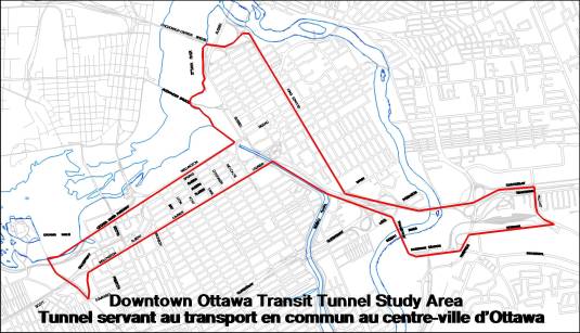
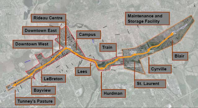
Figure 1- DOTT Study Area
The new transit
facility will see the construction of approximately 12.5 kilometres of new electrified light rail transit, between
Tunney's Pasture and Blair Stations.
Thirteen LRT stations have been identified along the proposed
route. Each station will be designed to
accommodate 180-metre long platforms (for future six-car trains needed beyond
the 2031 planning horizon). The tunnel
will span approximately 3.2 kilometres with four stations below grade serving
downtown and the University of Ottawa campus station.
East and west of
the downtown tunnel the existing Transitway will be converted from bus rapid
transit to light rail transit technology.
Within the 12.5 kilometres of this LRT project, approximately nine kilometres is conversion of the
Transitway. Investigations are underway
for a site suitable for a maintenance and storage facility, the findings of
which will be the subject of a future report to Committee and Council.
The general alignment and design of the stations that
have been evaluated are described below.
Figure 2 provides a general overview of the stations within the
corridor.
Figure 2- DOTT Alignment
DISCUSSION
The need for the DOTT Study is based on the acknowledgment that delays and
congestion in the downtown area are significant and of great concern when
planning for the redevelopment of the core area and meeting existing and future
transportation needs of the City and adjacent municipalities.
Transit
through downtown accommodates over 10,000 riders during peak hours. Currently, transit service is limited to 180
buses an hour along Albert and Slater Streets during peak times to meet the
travel demand. Effectively, the transit
system has reached its capacity in providing Bus Rapid Transit service through
the downtown to serve surrounding communities.
The system will no longer be able to expand service beyond 2018.
The TMP aims to
implement a series of initiatives whereby electrified light rail will:
·
Increase transit ridership and improve transportation
services throughout the region, and in particular, the downtown core area;
· Provide the transportation
infrastructure needed to support the City's projected population and employment
levels for the year 2031.
The
most significant initiative, and the subject of this study, is to:
· Construct a tunnel across downtown
Ottawa;
· Convert the existing Transitway
between Tunney's Pasture and Blair Station from bus to rail technology.
As
approved by Council, light rail transit will follow the established Transitway
route between Tunney’s Pasture Station and Blair Station via a tunnel through
the downtown to replace the existing on-street downtown transit. The need for LRT has been established
through the TMP exercise and refinements for the choice in technology are being
developed for Council’s consideration later this summer.
Objectives and Design Criteria
A set of objectives and design criteria and indicators
were established to
guide the evaluation and development of alternative
alignments and station concepts. The
evaluation objectives include:
·
Increase transit ridership and the
mobility of residents
·
Enhance Ottawa’s urban character and
national stature
·
Stimulate smart growth principles
·
Create rapid transit stations
·
Be compatible with adjacent
communities
·
Maintain or improve natural and
physical environments
·
Showcase sustainable design best
practices
·
Manage construction disruption and
risk
·
Result in wise public investment
The purposes of developing these
objectives and criteria are to:
- Enable a shared understanding by the City, the design team, and
all stakeholders of the project and its expectations;
- Implement planning and design directions of the Plan for Canada’s
Capital, Ontario’s Provincial Policy Statement, and the City’s Official
Plan and Transportation Master Plan Update;
- Form the fundamental planning objectives and basic design
assumptions;
- Provide guidance for designers and others to use when trade-offs
need to be addressed;
- Provide a foundation for the selection of criteria to be used in
the evaluation and assessment of alternative designs; and
- Form the basis for determining detailed design criteria and
indicators.
The Project Team, with feedback from the study’s three
consultation groups and the general public, completed the evaluation of the
preliminary alignments and stations.
The evaluation, criteria, indicators, and results are provided in Documents
1 and 2, respectively.
Design Segments
To
comprehensively undertake this study, the project was divided into 10 design
segments, described as follows and illustrated in Figure 3. The preferred design alternative for each
segment will be linked to create an overall preferred alignment and design for
the entire project.
Figure 3-
DOTT Design Segments
Segment Alignment and Station Configuration
Options
Segment 1:
Tunney’s Pasture
Segment 1 includes
the western limits of the preferred LRT alignment which follows the existing
Transitway alignment from Tunney’s Pasture Station to Parkdale Avenue. Tunney’s Pasture Station will serve as the
western terminus for BRT service from the west and southwest until such time
that the LRT system is expanded further in accordance with the TMP. The Station will accommodate bus and rail
transfers for approximately 9,000 passengers/hour during peak operating
times. Tunney’s Pasture is a major
employment node for the federal government (second largest employment centre
outside of the downtown). The
station will be designed to accommodate transfers between LRT and BRT for trips
not destined to Tunney’s Pasture on an interim basis until LRT is extended to
Baseline Station and the Western Transit Corridor is determined. The facility will provide a turn-around for
BRT. There will be a need to have some
transit continuing on Scott Street to facilitate connections to the O-Train and
Gatineau services at Bayview and LeBreton stations. Bus operation on Scott Street will be minimized to mitigate the
impact on adjacent lands and allow the federal campus to proceed with its
development initiatives. A number of operational considerations will be
addressed during the Environmental Assessment phase of the study to coordinate
downtown service, service to Gatineau via the Chaudière Bridge and transfer to
the North-South LRT.
Two station design
options were evaluated. For both
options, bus facilities will be located on the north side of the existing
Transitway. The Parallel Configuration
ranked highest in the evaluation of alternatives and is recommended because it
provides an efficient way to run BRT in and out of the Transitway west of the
station and it also provides an adequate lay-by area. This configuration also addresses bus service that will remain on
Scott Street to serve local and through service.
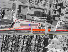
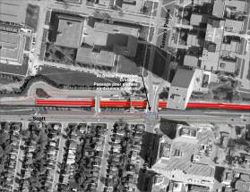
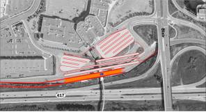
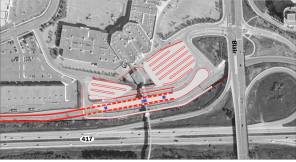
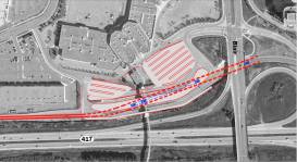
Figure 4 –
Tunney’s Pasture Station Configurations
Parallel Configuration Linear
Configuration
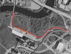
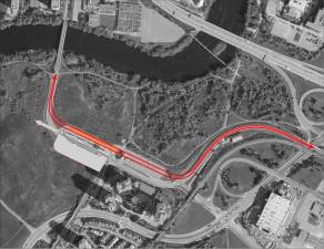
The LeBreton –
West Portal segment runs from Preston Street to the escarpment and generally
follows the Transitway corridor route to Booth Street and then continues
easterly toward the escarpment. The LeBreton alignment and station will
complement redevelopment of the LeBreton Flats and also continue to serve as a
transfer point to Gatineau via Booth Street and the Chaudière Bridge
crossing. This is an important transfer
point to employees headed to Place de Portage, Terraces de la Chaudière and for
transit riders entering the city from Gatineau.
The corridor is in an open trench west of Booth Street
and continues below grade towards Brickhill Street where the trench is deep
enough to launch the tunnel-boring machine into the limestone bedrock. The tunnel portal will be situated near this
location. The proposed grade and
gradient of the alignment effectively takes advantage of the existing
topography and minimizes impact on nearby features such as the aqueduct,
tailrace and existing roads. This
configuration is consistent with development plans for the area and provides
for the potential for joint development on the City’s escarpment lands. The corridor will be designed to allow
development to proceed over top of the alignment.
Three station
configurations were considered for LeBreton.
In all three options, the LRT alignment would be located slightly to the
south of the existing Transitway alignment in an open trench starting to the
west of Booth Street. This will permit
a reconstructed Booth Street to cross over the LRT corridor via a new bridge
structure. A centre platform configuration for the LRT station would be
provided. The primary difference
between the three options developed concerns how bus transit is accommodated at
this location.
The Bus/Booth
At-Grade Crossing configuration accommodates short-to medium-term bus
operations with a temporary bus facility south of the new LRT alignment. This bus roadway would cross Booth Street at
grade, much the way it does today. This
configuration would permit bus-to-bus transfers at grade with connections to
the LRT corridor below Booth Street provided from the new Booth Street bridge
spanning the LRT station. This option
serves the Gatineau/Ottawa transportation connection and the LRT component and
is consistent with plans to serve the future development of the LeBreton area;
however, the temporary bus lanes will delay future development south of the
aqueduct, and there are some throw-away costs associated with the temporary bus
facilities.
The Transit
under Booth Street configuration accommodates short-to-medium-term bus
operations with a temporary bus facility located within the LRT corridor, at
the same level as the LRT platforms and extending under the new Booth Street
bridge. This configuration would permit
most bus to rail transfers from a common platform. In the long-term, area occupied by the bus roadway could be
converted to public space. This option
serves the Gatineau/Ottawa transportation connection and the LRT component but
is not consistent with plans to serve the future development of the LeBreton
area due to additional land requirements.
There are significant costs associated with the temporary bus
facilities.
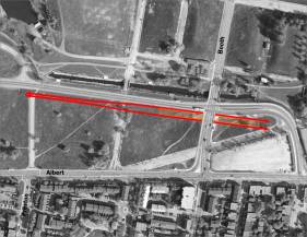
The Buses on
Booth/Albert configuration accommodates bus operations on the new Booth Street
bridge over the LRT Corridor, which will be wide enough to accommodate bus
lanes and waiting areas for passengers. The lack of dedicated bus facilities at
this location will require that bus service either loop on-street or at an
alternative bus terminal location. Bus operations will need to be developed and
confirmed as part of the functional design process. Transit users transferring at this location will be well served
from either direction with minimal travel time between stations and
platforms. This configuration is recommended
as it has fewer infrastructure requirements and would allow residential
development south of the aqueduct to proceed more quickly. This option also allows for flexibility in
the implementation of decisions that will arise from the Interprovincial
Transit Strategy.
Figure 6
Bus/Booth At-Grade Crossing Configuration Transit Under Booth Street
Configuration
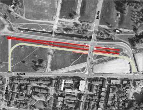
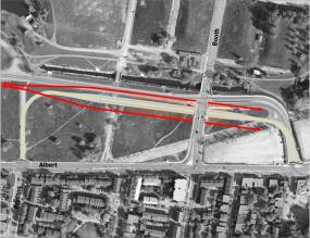
Buses on Booth/Albert Street
Configuration
Segment 4: Downtown
Alternative Alignments
The Downtown Segment includes the area through
the downtown core from the escarpment to King Edward Avenue. A number of alignment options were explored
to construct a tunnel across the downtown core. Alignment options include: two tunnels under one street; one
tunnel under adjacent streets; two stacked tunnels; and a “cross-country”
alignment. Alignments were explored
under Sparks, Queen, Albert and Slater Streets. Tunnels under Wellington Street and Laurier Avenue West were not
considered because of proximity to sensitive federal lands in the parliamentary
precinct and poor geotechnical conditions, respectively. In addition, these corridors are located
toward the edge of the developed areas, rather than being centrally located in
the core for convenience of accessibility.
Figure 7 – The Cross-Country Alignment
Stations and platform configuration
The
configuration of the platforms in the downtown tunnel is based on a set of
specific objectives and design criteria.
Six
objectives were developed and are listed below:
·
Security and Life Safety
·
Enhance Ottawa’s Urban Character and Express
National Stature
·
Showcase Sustainable Design Best Practices
·
Manage Construction Disruption and Risk
·
Result in a Wise Public Investment
·
Platform Configuration Alternatives
The
recommended alignment and station configuration is the cross-country route with
centre platform stations that generally follow, from west to east:
·
Under
Albert Street, with the Downtown West station in the Lyon/Bay block,
·
Turning
slightly to the north at Bank Street to cross under Queen Street at O’Connor,
with the Downtown East Station centered on O’Connor, then
·
Continuing
cross-country toward Rideau Street, with a Rideau Station spanning under the
Canal and Rideau Street, from just west of the canal to the Freiman Mall, then
·
Sweeping
to the south under Rideau, Waller and Nicholas to connect to Campus Station.
This
alignment is the most direct and cost efficient route (high-level estimates)
for the tunnel. The alignment can be
constructed easily, and will have low on-going maintenance costs as the
curvature is minimized. It services a
large percentage of the existing and potential development in the downtown, and
is technically the most feasible given geotechnical conditions and construction
considerations.
Segment 5: Laurier – East
Portal – Lees
This segment is
characterized by a centre platform configuration at Campus Station that serves
the University of Ottawa and a side platform configuration at Lees Station,
which is located within the Transitway corridor slightly north of the existing
platform. The preferred location at
Lees Avenue also presents the potential future connection to the adjacent Mann/Lees
development lands. Known site contamination
in the vicinity of Lees Station limits expansion at this location, therefore
keeping the station within the existing corridor will avoid further remediation
costs. This alignment uses the existing
Rideau River Bridge to Hurdman Station.
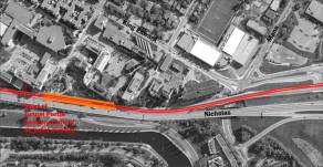
The eastern portal of the tunnel is located in this
segment. The location of the portal was
determined based on a number of factors: minimizing impact on the University
and Nicholas Street; allowing for temporary bus operations around the
construction zone; minimizing disruption to infrastructure in the area; and
maximizing the use of the tunnel boring machine. Three portal locations were considered for Campus Station and are
illustrated in Figure 9 (north of
Campus Station; south of the existing Campus BRT Station; and south of Mann
Avenue).
Based on geotechnical conditions, the portal located
south of Mann Avenue is recommended. An
opportunity to provide a below grade station that will be integrated with
existing and future buildings and pedestrian systems ranks high in desirability
and cost efficiencies. With the portal
located further south, the TBM can be extracted at a construction staging area
and the portal entrance will be completed with typical cut and cover technology
since the tunnel is out of the limestone bedrock condition and into the glacial
till characteristic of Sandy Hill. The
portal at this location also lends itself well to eliminating a portion of the
existing Transitway corridor adjacent to the University, thereby providing
opportunities for landscaping along the university/canal corridor, enhancing
the Capital Entry along Nicholas and providing good separation between Nicholas
and the University campus.
Figure 9
– Campus Station
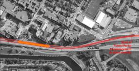
North Portal Configuration
Figure
10 –Lees Station
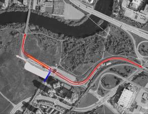
Segment 6: Hurdman
The Hurdman segment begins at the Rideau
River, crossing toward Hurdman Station and extends to Riverside Drive. The preferred alignment generally follows
the existing Transitway corridor and is adjacent to National Capital Commission
(NCC) vacant lands (part of a former landfill). The
NCC intends to develop lands to the north of Hurdman Station and therefore an
appropriate access to the site is required.
This will be achieved by extending an elevated LRT alignment to go over
an extended Industrial Avenue, which will serve the development parcel. This elevated alignment will continue to use
the existing Transitway bridge over Riverside Drive as it approaches the Via
Rail Station.
The
alignment must also maintain access to the Southeast Transitway, improve access
for pedestrians and passenger drop-off at Hurdman Station and minimize impacts
on the adjacent residential high-rise development.
Three
configurations were developed for this station, as illustrated in Figure
11. For all three options, the LRT will
be raised onto an embankment and the existing bus layover facility will be
moved to the west on the south side of the bus platform area.
The first
configuration (Horizontal North) places the LRT platforms on a raised
embankment north of the existing station, and reconfigures the bus loop as a
one-sided platform parallel to the LRT, in and arrangement similar to Billings
Bridge Station.
The second
configuration (LRT Over Existing) would place the LRT platform directly over
top of the existing Hurdman bus platform.
While this would minimize transfer distances, it would be the most
disruptive to bus service at this station during construction.
The third
configuration rotated the LRT station slightly to allow for a future rail
connection to the Southeast Transitway.
The geometry of the site makes this configuration impractical in that it
requires more land from the NCC and lessens the development potential of the
property.
The
Horizontal North configuration is recommended.
Figure 11 – Hurdman Station
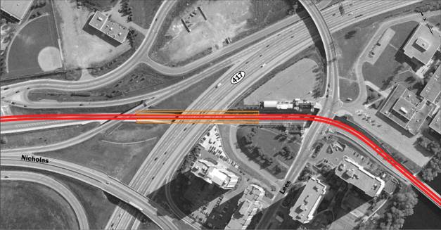
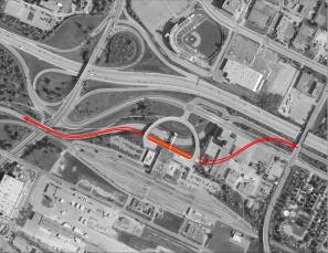
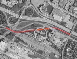
Segment 7: VIA Rail
Station
This
segment runs from Riverside Drive to Belfast and follows the existing
Transitway corridor with some deviation outside the corridor at the Train
Station. The two configurations considered are illustrated in Figure 12. The Front Door configuration would line the
platform up with the main entrance to the VIA Train Station, but require an
underground connection back to the existing corridor north of Tremblay Road.
The
Diagonal configuration adjusts the track alignment to smooth out the existing
tight curves of the Transitway and provides access from the train station and
development lands to the east and north.
This station will be a side platform arrangement to allow for the
optimal track geometry. This
configuration also presents the potential of a future grade separated
pedestrian crossing of Highway 417 as development progresses north of the
highway. The Diagonal configuration is
recommended.
Figure
12- Via Rail Station
The St.
Laurent segment is basically a conversion of the Transitway to LRT service
between Belfast Road and Michael Street.
Local bus access will continue to be important, as this service will be
focused on the station and efficient transfers from local routes. Local bus service will be accommodated at
the existing upper level bus platforms with the potential for additional
vertical access explored at the eastern end of the new, longer, station
platform. Station options relate to the
appropriate platform layout at the existing lower level. After review of both a Centre Platform and
Side Platform configuration, continuation of the side platform arrangement will
make the best use of the existing facility and contain costs associated with
conversion to LRT.
Figure 13 – St. Laurent Station
St. Laurent Station – Side
Platforms St. Laurent
Station – Centre Platforms
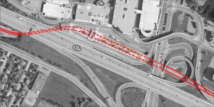
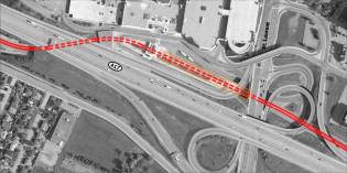
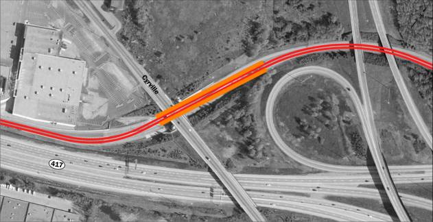
Segment 9: Cyrville
Segment 10: Blair
The Blair segment is the most easterly
section of the new LRT corridor and will extend from the Aviation Parkway to
Blair Road. It will operate as a
terminal station and major transfer point, serving transit users in the eastern
part of the city. This station will
connect the East
Transitway, Cumberland Transitway and local bus service
A centre
platform configuration will best serve the station and will effectively
accommodate transfers from BRT service to LRT as well as terminating
trains. A staging area will be required
for BRT service connections and access to drop-off and parking will be
developed through the functional design stage of this study.
The three
configurations are shown in Figure 15.
The LRT on Upper Level configuration would place the LRT on the existing
Transitway level, with the local bus area to the north being reconfigured. This option has geometric constraints for
extending the line to the east, and the local bus area does not provide
adequate capacity for the volumes of transfers anticipated.
The LRT on
Lower Level configuration would require reconstruction of the Transitway Level
into a larger bus terminal sitting over top of the LRT, constructed just below
the lower local bus area. This
configuration provides adequate space for bus transfers and optimizes the use
of the area.
The LRT
Shifted East configuration locates the LRT platform far enough east to allow
for an access point on the east side of Blair Road. This is more challenging to construct, but would allow for a more
direct connection for local passengers east of Blair Road.
The LRT on
Lower Level configuration is recommended.
Figure 15 – Blair Station
LRT on Upper Level Configuration LRT
on Lower Level Configuration
LRT Shifted East Configuration
Maintenance and Storage Facility
Ten potential sites were examined
and are currently being evaluated based on the four evaluation factors
developed for the facility, namely:
·
Site
Characteristics (topography, grade, land use compatibility, expansion
capability and environmental considerations),
·
Facility
Operations (turnaround loops, track redundancy, layout efficiency and municipal
services)
·
System
Operations (connectivity to the line, efficiency and access to freight rail),
and
·
Relative
Costs (capital, operating, maintenance and property ownership and acquisition)
The
facility requires a parcel of approximately 12 hectares to accommodate all
required functions to operate the LRT.
All of the sites require property not under the ownership and control of
the City. Public consultation on this issue will take place once the technical
analysis is complete and results will be reported to Transit Committee and
Council as part of the final Environmental Assessment.
Key Issues Arising
from Consultation
Generally there is strong
public support for this project, however some key issues arose during
consultation. These are:
Surface vs. Tunnel
through the Downtown
Concerns were
expressed regarding the implications of changing from a surface (on-street)
transit system to a grade-separated rapid transit (tunnel) system in the
downtown, such as: security, travel time, wayfinding (particularly for visitors
and tourists). The cost of constructing a new tunnel versus accommodating
LRT on the surface was also seen as an issue considering the current economic
climate.
The DOTT Study
follows Council’s recognition and direction that rapid transit needs to be
separated from private vehicular and commercial traffic, particularly if
long-term transit needs are to be met. An assessment of the downtown
transit network (undertaken as part of the TMP update) examined the feasibility
of surface rapid transit options (both BRT and LRT) and concluded that surface
rapid transit did not meet the City’s long-term needs and that grade-separation
would be required in order to provide a rapid transit system capable of
carrying projected demand in a manner which is fast, reliable and convenient.
2031 forecasts will
require four-car LRT trains operating at approximately two to three‑minute
headways during the peak hour. A four-car LRT train would be
approximately 120 metres in length. This length cannot be
accommodated on downtown surface streets without significant impacts to
property access, loading and on-street parking. Using shorter two-car LRT
trains would require a train every 60 seconds to accommodate projected
demand. Given existing traffic signal cycle lengths in the Albert/Slater corridor,
one train would need to be accommodated every cycle. Any delay would
significantly impact LRT operations.
The tunnel and
stations will be designed to accommodate latest standards with respect to life
safety and security. While every possible eventuality cannot be foreseen,
it is noteworthy that citizens of many other large cities continue to ride
underground rapid transit systems in large numbers.
While underground
stations cannot match surface stations in terms of the time required to reach
platform level, it should be understood that surface transit cannot match the
travel time savings which a grade-separated LRT system will provide over
existing downtown transit. Other benefits include separation from
inclement weather and disruptions caused by traffic congestion on the surface.
The time it takes
to access a tunnel station is generally not seen as a penalty but part of the
travel time required for the trip. The
final Environmental Assessment report will examine ways of reducing tunnel
depth and improving access from street level during the functional design
exercise. For example, reducing walking
distances with construction of two major access points and the potential for
additional internal connections to buildings and street level will improve
direct connections to transit for downtown users, particularly during inclement
weather.
Number of
Stations in the Core Area
There are four
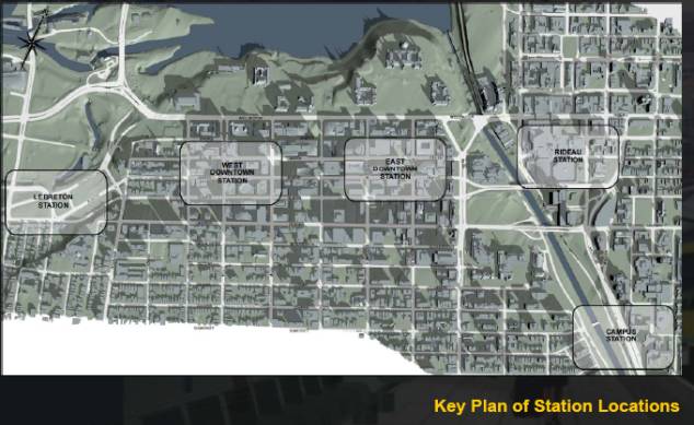
underground stations planned to serve downtown Ottawa: Downtown West,
Downtown East, Rideau and Campus. LeBreton Station, to the west of the
core area will also serve development on the west side of downtown, including
the proposed Escarpment Area development. Comments received during the
consultation process have indicated a desire for either more, or fewer stations
in the downtown Ottawa. Those advocating more stations have typically
expressed concern over the spacing between downtown stations compared to other
cities, the catchment area of each station, and the distance required to access
each station given the potentially deep level of the tunnel. Others
advocating fewer stations for the downtown state vehicle travel time and cost
savings as concerns.
Existing subway
systems in Toronto and Montreal have stations in their downtown spaced at an average
distance of approximately 500 metres.
These stations typically have a single primary access point from the
platform level, with multiple accesses provided to the street from a single
mezzanine level. Between LeBreton and Campus, stations on the DOTT
are spaced 535 metres apart; on average. While this provides a slightly
wider station spacing than that found in Toronto and Montreal, it is noteworthy
that each DOTT station will have at least two major accesses points from the
platform level, providing increased coverage for each station compared to
downtown stations found in Toronto and Montreal. Population and
employment densities in downtown Toronto and Montreal are also significantly
higher than those of downtown Ottawa, with greater potential for increased
future development.
The study examined
pedestrian movements through the downtown area and considered walking distances
to tunnel LRT stations. Using a benchmark of 300 metres and 500 metres
walking distances showed that the majority of the downtown area was within the
catchment area of a station, as measured from the mid-point of the platform
area. Separate access points from the platform level helps lessen the
walking distance and travel time to the station. Walking distances are
consistent with other subway station arrangements and are consistent with the
City’s guideline for walking distances to transit stations.
Overall, the
proposed number of stations serving the downtown area has struck a balance
between optimal station spacing for transit vehicle performance and in-vehicle
travel time and the need to provide access and coverage to the downtown
area. Given the significant cost of constructing underground stations,
provision of additional stations in the downtown is not recommended.
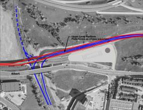
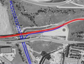
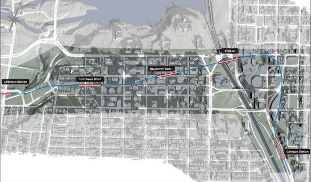
Queen vs. Albert
Street Location for the Downtown East Station
The Downtown
Coalition’s cross-country alternative seeks to move the alignment southerly
under Albert Street before veering at Metcalfe Street towards Rideau
Station. This alternative was examined in detail. The proposed alignment captures slightly
more potential transit users by 2031.
However, the study still recommends the alignment along Queen Street for
the following reasons:
· Less tunnelling due
to a more direct route to the next station;
· Less costly due to
a shorter route and less technically challenging boring strategy;
· Provides an
acceptable walking distance to the station;
· Does not require an
“S” curve to reach Rideau Station;
· Avoids some
technically difficult situations moving under and around the Bell Transfer
Station Building and the World Exchange Plaza;
· Provides a smoother
more comfortable ride through the core;
· Will require less
maintenance on vehicles due to a straighter alignment (wheels).
Rideau Centre
Station
The recommended
tunnel alignment at Rideau Station serves multiple purposes, including
facilitating local transit connections, access to the Byward Market, Rideau
Centre and retail on Rideau Street, the Ottawa Conference Centre and the
National Arts Centre and Confederation Square.
This station
location best suits the LRT alignment from a functional and operational
perspective. Local and regional transit will be well served by the
station as it will act as a hub for riders destined to this area of the downtown;
with the number of above grade transfers and travel time minimized because of a
smooth transition between local and regional traffic as well as the opportunity
to transfer to local routes at other stations along the LRT network.
Other alternative
alignments and station designs were investigated and evaluated including one
under the Rideau Centre aligned with Daly Street and another aligned with the
existing Mackenzie Station. Both of these alternatives present a
technical challenge because of the geotechnical conditions and the existing
Rideau Centre or Mackenzie King Bridge structures, which are supported on
piles. The TBM would have to pass through an array of piles while
negotiating a grade differential as the curve and rise toward the south begins.
The construction of a station along either Daly or Mackenzie King would be
challenging and costly as access from the station to the surface would be
difficult to achieve. Construction on
either of these alignments increases the risk of creating long-term problems
with settlement of Rideau Centre or Mackenzie Bridge. The Mackenzie King alignment would also be immediately adjacent
to the Department of National Defence Headquarters building which could once
again raise security concerns that were expressed during the North-South LRT
Project.
Viking Rideau
Corporation indicated that the recommended alignment would not be suitable for
the operation and future growth of the shopping complex since primary transit
movements would be focused at the Rideau Street end only, rather than
distributed between Rideau Street and Mackenzie King Bridge as currently
exists. Viking Rideau Corporation
supports the Mackenzie King alignment for the LRT.
Downtown Rideau BIA
also expressed a preference for regional and local transit to be in separate
corridors (as is currently), with the new LRT service to be on Mackenzie King
Bridge. The BIA does not support
regional and interprovincial transit services being concentrated in one corridor
due to concerns of further impacts on Rideau Street.
The study
recognizes that bus surface operations (on Rideau Street and on Mackenzie King
Bridge) will need to be reviewed in detail in order to find a solution that
becomes transit service needs, with business/community needs.
Other Issues
Risk Assessment
A risk assessment was conducted
on the Downtown Ottawa Transit Tunnel project, an update to the risk assessment
of the Council Approved Rapid Transit Network conducted in the fall of 2008.
Several risks identified at that time no longer apply, generally due to
decisions made with respect to the design options which have increased costs,
but reduced the risk of further cost increases. There are a number of
risks remaining that may result in cost increases or delays for the DOTT project.
The key risks include competition and shortage of skilled professionals due to
increased investment in other transit and infrastructure projects, perception
the project may not proceed to contract, and delays with needed approvals,
particularly with Transport Canada and the construction of downtown stations.
Other risks that remain include scope changes around station access and design,
inflation and exchange rate fluctuations, and the need to acquire land/property
rights.
The estimated costs and designs are still
at a fairly high level. The level of design is still at a conceptual level, and
more certainty will not be available until the preliminary design is completed
this summer. The estimated costs of the project have increased since the
TMP due to design recommendations and risk mitigation, including an extension
of the tunnel length placing the Campus station below grade, and further
review of the site for a maintenance and storage facility. The City has
initiated and will need to continue all the risk mitigation activities
identified. The resolution of the
Transport Canada approval will be initiated shortly.
TMP Investment Strategy
In November of 2008 City Council
directed staff to undertake Phase 1 of the Investment Strategy
for the TMP. The Investment Strategy
identifies costs and revenues that will be required to fund the entire TMP over
the next 22 years. Phase 1 of the
strategy required a review of all of the potential financial tools
that may be available to fund the plan. This review was to
consider tools that currently exist under the Municipal Act such
as development charges, Local Improvement Charges and those that may
require new taxing authority through amendments to the Ottawa Act (e.g.
road tolls).
To carry out this assignment, staff hired
KPMG who have now undertaken a complete review of all financial
tools that have been used in other jurisdictions that may have
application for Ottawa's Transportation Master Plan. The consultant has also provided a preliminary
assessment of the amount of revenue each tool may yield for the City's
TMP. Staff is currently reviewing this
study and a report will be brought back to Committee in June with recommendations
on the analysis.
Preliminary discussions with respect
to the transit station development and land acquisition also took place with
groups such as the Downtown Business Coalition and Viking Rideau in
anticipation of the next phase of the EA study and government funding.
Staff
discussed preliminary engagement principles and possible incentives that may be
deployed to secure the necessary land within the preferred transit corridor and
how transit stations may be jointly developed.
In the absence of full project funding, staff suggested that Memorandums
of Understanding could be entered into with landowners within the corridor and
at station locations that would establish key business principles on how land
would be acquired and stations developed.
As well staff engaged the MMM group
to look at best practices and lessons learned from other LRT projects that
required land and stations to be developed in existing downtown areas. Current practices and strategies to engage
developers in both Canada and the United States were reviewed including in-depth
interviews with the Toronto Transit Commission, TransLink (Vancouver) and the
Chicago Transit Authority.
The MMM review noted that several
agencies in North America such as Viva Transit (York Region), TransLink and the
WMATA (Washington, DC) take a proactive approach to engaging land owners and
developers. In many jurisdictions, it
is recognized that there is a reciprocal relationship with positive benefits
that occur with integrating direct transit access through higher density
development that can in turn reduce vehicular travel, increase ridership,
reduce developer and landowner cost and increase property owner revenues and
most importantly create improved communities through Transit Oriented Design
(TOD).
MMM
noted the importance of early engagement of property owners within the transit
corridor so that relationships can be established and concerns and
opportunities addressed. Examples of
tools that are typically deployed to obtain station access and TOD objectives
include:
·
Use
of joint development agreements or other forms of strategic partnerships;
·
Leasing
of air rights above stations and on other land holdings that allow for
additional development directly connected to the transit system;
·
Reduced
parking requirements that save land owners parking construction and maintenance
costs as a result of providing station connections;
·
Clear
station connections policies that outline the required agreements, connection
fees and capital costs, insurance, design, construction, operation and
maintenance requirements; and
·
Station
designs that allow for multiple connection opportunities that provide for
future connectivity at reduced costs.
MMM
noted that tools such as those mentioned above have been deployed on the new
Canada Line in the Vancouver area, redevelopment and intensification along
Sheppard Avenue in Toronto related to the new Sheppard Line and the continued
redevelopment in the downtown core of the City of Toronto, where direct transit
access is considered a benefit to the overall development project.
Next Steps
MMM has recommended a number of
strategies that the City can deploy related to station development and land
acquisition as the EA process advances and project funding is secured. Examples include releasing a Request for
Information (RFI) to identify willing stakeholders and partners and explore
their ideas in developing transit stations, station access and TOD
developments. Identify and consider the
advanced purchase of strategic properties that will assist the City in
leveraging those assets for transit infrastructure improvements. Explore opportunities for land exchanges,
strategic partnerships or joint ventures with various landowners that address
both the City's and the land owner’s needs.
Create a City of Ottawa Station Connection Policy that addresses issues
such as capital costs, connection fees, liabilities, access rights, maintenance
and related issues to ensure that the requirements for station connections are
clear to all stakeholders. As well
ensure that all stakeholders understand the social, economic and environmental
benefits of connecting to the transit system.
Staff
recommends that Council authorize the release of an RFI to solicit ideas from
property owners in or adjacent to the preferred corridor. As this is simply an RFI, the information
that is provided will not bind Council or the party providing the
information. In June staff will bring
back a report on how other strategies identified by MMM such as strategic real
estate acquisition can be used to advance the City's transit objectives.
Status On TMP Procurement
In November of 2008 City Council directed
staff to speak to Infrastructure Ontario(IO) about Ottawa’s TMP project.
Meetings were held this winter with Senior IO and City staff on this matter and
the following summarizes these discussions and the status of the TMP
procurement process.
1. Senior IO staff have
expressed an interest in undertaking an Alternative Finance Procurement (AFP)
and project implementation assignment for Ottawa's TMP project. Components of
the TMP project that will be assigned to IO for review are currently under
discussion however the LRT, tunnel and the LRT stations have been suggested to
go through a preliminary financial analysis. If the conclusions of this
analysis are positive, greater cost savings and efficiencies will be realized
by procuring the project by way of an AFP vs. a convention procurement method.
If they are negative IO has indicated that they will not be the delivery agent
for the project as their mandate is to only undertake AFP assignments.
2. To establish whether there will be savings
and efficiencies in undertaking an AFP vs. a convention procurement approach,
IO's preliminary financial analysis involves undertaking an initial Value for
Money (VFM) assessment. This assessment will take approximately 8 weeks to
complete once sufficient project information is submitted to Infrastructure
Ontario. To start the analysis staff has reviewed IO's terms of reference for
the preliminary VFM assessment. Staff have also submitted certain project
information to IO which will be further supplemented when the technology forum
and functional design stage of the EA process are completed this summer.
- Staff will be
reporting back to Council in July with IO's initial analysis and all of
the procurement options that were analyzed. Should the preliminary value
for money assessment for an AFP procurement demonstrate best value, staff
will seek direction from Council to execute a contract with IO for the
procurement and project delivery elements. This report will also speak to
the project scheduling under an AFP process and key milestones going
forward.
ENVIRONMENTAL IMPLICATIONS
The study will
examine and evaluate the project’s effects on social, physical and natural
environments within the study area.
Appropriate mitigation measures will be developed and post mitigation
environmental impacts will also be determined.
CITY STRATEGIC DIRECTIONS
The
recommendation contained herein aims to support the following Strategic
Directions adopted by Council on 11 July 2007:
B3 Attain transit goals
(30 per cent modal split) by 2021.
E9 Require walking,
transit and cycling oriented communities and employment centres.
F4 Ensure that City
infrastructure required for new growth is built or improved as needed to serve
the growth.
CONSULTATION
This study involved over 150
stakeholder groups, including community organizations, property owners and
businesses within the study area, institutions, approval agencies and groups
with a special interest in the study.
In addition to the Agency, Business and Public Consultation Group
meetings (four meetings each), a formal Public Open House and presentation was
conducted on 26 February 2009 and was attended by more than 150
people. Individual meetings were also
arranged with groups such as the Downtown Coalition, Viking Rideau Corporation,
the University of Ottawa, and the NCC.
A project website (www.ottawa.ca/tunnel) was established along with a
dedicated e-mail address (dott@ottawa.ca)
to allow the public to contact the study team directly. Consultation efforts will continue as the
study progresses. A summary of
consultations undertaken to date is provided in Document 4.
LEGAL/RISK MANAGEMENT IMPLICATIONS
There are no Legal/Risk Management
impediments to implementing this report's recommendation.
FINANCIAL IMPLICATIONS
Detailed
costing of the fully scoped project will be carried out in the functional
design phase of this study. Costing
information will include an estimate for property acquisition, design, project
management, construction, vehicles, and escalation.
Funding for the DOTT Planning and
Environmental Assessment Study is available in the Capital Budget, project
number 902135: Rapid Transit EA
Studies.
SUPPORTING DOCUMENTATION
Document 1 Draft Evaluation Criteria
Document 2 Evaluation of the Alternative Alignments
Document 3 Station Configuration and Platform Designs
Document 4 Summary of Public Consultation
DISPOSITION
Following
Committee and Council approval of the recommendations contained herein, the
Planning and Growth Management Department will continue with the Planning and
Environmental Assessment Study for completion in January 2010 and release a Request for
Information (RFI) to property owners within and adjacent to the recommended
corridor alignment to solicit ideas on station access, development, design,
and other matters with the aim of improving ridership,
ridership experience and lowering City costs.
DRAFT EVALULATION CRITERIA DOCUMENT
1
March, 2009
1.0 EVALUATION OF ALTERNATIVE ALIGNMENTS AND
STATIONS
1.1 Evaluation Methodology
The methodology described below was adopted
for the evaluation of alternative alignments and stations for the DOTT
project. The methodology is based on
the Project Planning Objectives and Design Criteria described in Section 7.0
and was applied to a set of alternative alignments developed by the Study Team
to a level of detail that allows all benefits and effects to be determined.
The Project Planning Objectives and Design
Criteria were reviewed to determine the ones that would influence the choice of
alternative alignments and stations.
Some, such as designing to meet the Ontario Building Code, will apply to
all designs and were not included in the development of Indicators to evaluate
the alternatives. From the short list
quantifiable and qualitative Indicators were identified as factors considered
important to compare alternatives.
The Objectives and related Design Criteria,
along with the draft Indicators, were reviewed with the Consultation Groups to
ensure that they were appropriate and reflect the effects of the alternatives
in relation to each area. After
integrating comments from the Consultation Groups where appropriate, the
evaluation of alternatives was conducted by the Project Study Team and the
results were presented to the Consultation Group members for their
feedback.
A comparative evaluation methodology was
followed, with each alternative ranked in terms of its “Responsiveness” to the
relevant Design Criteria on a scale of 1-4, from most to least responsive,
using the Indicators identified. The overall most responsive alternative was
then identified by summarizing the degree to which each of the Design Criteria
and associated Indicators were met. The
Responsiveness was ranked for each of the alternatives.
The evaluation will then be presented at a
Public Open House and Presentation for review and discussion. Public comments will be received and
incorporated, where appropriate into a recommendation to Committee and Council. The recommended alternative adopted will
allow for some local area variations to be developed and further evaluated as
necessary to refine the technically preferred alternative.
1.2 Evaluation Objectives and Indicators
The following table presents the Evaluation
Objectives and Design Criteria, along with the relevant Indicators which were
used in the evaluation of alternative alignments and stations.
Table
1-1: Evaluation Objectives, Design
Criteria and Indicators
|
Objective
A: Increase Transit Ridership and
Mobility
|
|
Design Criteria
|
Indicator
|
|
A-1
|
Modal Split
Target
|
Ability to
accommodate high service frequencies
|
|
Compatibility
with existing or planned transit, pedestrian and cycling networks
|
|
Existing and
future population/employment densities served
|
|
|
|
A-2
|
Rapid Transit
Travel Time
|
Number of curves
that restrict speed
|
|
Overall length
of the alignment
|
|
Station spacing
|
|
|
|
A-3
|
Travel Comfort
|
Number of curves
that restrict speed (or require maximum superelevation)
|
|
Maximum % grade
|
|
Maximum station
depth
|
|
No. of curves
less than 100 m radius
|
|
|
|
A-4
|
Rapid Transit
Network Connectivity
|
Connections to
existing and future rapid transit links
|
|
Directness of
transfers to/from different rapid transit lines
|
|
Ability to
interline services
|
|
|
|
A-5
|
Bus Transit
Network Connectivity
|
Connections to
existing local OC Transpo bus routes
|
|
Ability to
provide dedicated local transit facilities
|
|
Directness of
transfers to/from local bus routes
|
|
|
|
A-6
|
Interprovincial
Transit Connectivity
|
Connections with
existing STO transit service
|
|
Provides
opportunity for future Ottawa-Gatineau rapid transit links
|
|
Directness of
transfers to/from STO transit
|
|
|
|
A-7
|
Passenger Rail
Connectivity
|
Directness of
link to VIA Rail Station
|
|
Directness of
transfers to/from VIA Rail Station
|
|
|
|
A-8
|
Pedestrian
Network Integration
|
Connections to
dedicated pedestrian facilities
|
|
Number of
pedestrian crossings closed/diverted
|
|
Compatibility
with future pedestrian networks in planned development areas
|
|
|
|
A-9
|
Cycling Network
Integration
|
Connections to
cycling facilities
|
|
Ability to
provide accommodate bicycle parking, access
|
|
Number of
cycling crossings closed/diverted
|
|
Compatibility
with future cycling networks in planned development areas
|
|
|
|
A-10
|
Recreational
Pathway Integration
|
Connections to
multi-use pathway system
|
|
Provision of
parallel pathways
|
|
Number of recreation pathway crossings
closed/diverted
|
|
Compatibility
with future pathway networks in planned development areas
|
|
A-11
|
Road Network
Integration
|
Connections to
road network
|
|
Provision of
pick-up/drop-off facilities
|
|
Number of roads
closed/diverted
|
|
Compatibility
with future local road networks in planned development areas
|
|
|
|
Objective
B: Enhance Ottawa’s Urban Character
and National Stature
|
|
Design Criteria
|
Indicator
|
|
B-1
|
National Capital
Symbolism
|
Connections to
important Capital destinations
|
|
Supports NCC
Plan for Canada’s Capital
|
|
|
|
B-2
|
Downtown Ottawa
|
Compatibility
with Downtown Urban Design Strategy
|
|
Supports NCC
Core Area Sector Plan
|
|
Compatibility
with the Escarpment Plan
|
|
|
|
B-3
|
Arrival Route
|
Offers scenic
views on approach to downtown
|
|
Portal locations
integrate into landscape
|
|
|
|
B-4
|
Civic Places
|
Connections with
existing or planned civic spaces
|
|
Ability to
create vibrant public spaces
|
|
Ability to
revitalize underutilized public spaces/areas
|
|
|
|
B-5
|
Architectural
Quality
|
N/A
|
|
B-6
|
Views
|
Maintains and
enhances existing and protected views and vistas
|
|
Provides
opportunities for riders to experience views
|
|
|
|
B-7
|
Streetscaping
|
Ability to
integrate station entrance locations into streetscape
|
|
|
|
B-8
|
Private Property
Integration
|
Ability to
integrate station entrances into private property
|
|
Provides
multiple options for entrance locations
|
|
Ability to
provide seamless and cohesive station access locations within private property
|
|
Supports
downtown development objectives
|
|
|
|
B-9
|
Public Art
|
N/A
|
|
Objective
C: Stimulate Smart Growth
|
|
Design Criteria
|
Indicator
|
|
C-1
|
TOD
Intensification
|
Station
locations in proximity to existing or planned higher density uses
|
|
Station
locations in proximity to vacant or underutilized lands with the potential
for higher density development
|
|
|
|
C-2
|
Mixed Use
Centres
|
Station
locations support designated Mixed-Use Centres
|
|
Ability to
provide station entrances in Mixed-Use Centres
|
|
|
|
C-3
|
Brownfield
Reinvestment
|
Ability to
stimulate private investment in brownfield redevelopment
|
|
|
|
C-4
|
Downtown
Business Vitality
|
Station
locations in proximity to major downtown office and retail destinations
|
|
|
|
Objective D:
Create Successful Rapid Transit Stations
|
|
Design Criteria
|
Indicator
|
|
D-1
|
Capture Area
|
Existing and
future population/employment densities within 300/500 m walking distance of
stations
|
|
Percentage of
downtown inside 300/500 m walking distance to a station
|
|
|
|
D-2
|
Building
Integration
|
Opportunities
for station integration with existing or planned development
|
|
Opportunities
for station integration with existing or planned tourist destinations
|
|
Ability to
provide below-grade retail connections at stations
|
|
|
|
D-3
|
Personal
Services
|
N/A
|
|
D-4
|
Spacing
|
Average station
spacing
|
|
Number of
stations less than 500 m apart
|
|
Number of
stations more than 1000 m apart
|
|
|
|
D-5
|
Capacity
|
Ability to
provide station facilities matching expected ridership for the year 2031
|
|
Ability to
provide capacity for special events crowds
|
|
|
|
D-6
|
Passenger
Circulation in Stations
|
Station depth
|
|
Ability to
provide direct connections from grade
|
|
Minimizes number
of level changes required from platform to grade
|
|
|
|
D-7
|
Transfer
Stations
|
Directness of
transfer movements
|
|
Avoids conflicts
between vehicles
|
|
Supports safe
and efficient movement of vehicles
|
|
Supports safe
and efficient movement of people
|
|
|
|
Objective
D: Create Successful Rapid Transit
Stations
|
|
Design Criteria
|
Indicator
|
|
D-8
|
Platform Length
|
180 m platform
length accommodated easily
|
|
|
|
D-9
|
Platform Access
|
Ability to
provide multiple platform access points
|
|
|
|
D-10
|
Building Code
|
N/A
|
|
D-11
|
Barrier Free
Design
|
Maximum station
depth
|
|
Ability to
provide direct platform to grade connections
|
|
Minimizes number
of level changes required in underground and transfer stations
|
|
|
|
D-12
|
Elevating
Devices
|
Ability to
provide elevator and escalator redundancy
|
|
Minimizes number
of level changes
|
|
|
|
D-13
|
Wayfinding
|
Ease of
orientation
|
|
Station depth
|
|
Station access
locations in proximity to major destinations
|
|
|
|
D-14
|
Branding
|
N/A
|
|
D-15
|
Durability and
Maintenance
|
N/A
|
|
D-16
|
Noise and
Vibration Management
|
Station
locations in proximity to sensitive uses
|
|
Station
locations in proximity to residential uses
|
|
|
|
D-17
|
Ventilation
|
N/A
|
|
D-18
|
Ventilation
Exhaust
|
N/A
|
|
D-19
|
Fare Collection
|
Ability to
provide adequate space at station locations
|
|
|
|
D-20
|
Signals and
Communication
|
N/A
|
|
D-21
|
Climate Control
|
N/A
|
|
D-22
|
Personal Safety
|
N/A
|
|
D-23
|
System Security
|
N/A
|
|
Objective
E: Provide Safe and Efficient Linear
Infrastructure
|
|
Design Criteria
|
Indicator
|
|
E-1
|
Route Length
|
Minimizes length
of route
|
|
Minimizes length
of tunnel
|
|
|
|
E-2
|
Transitway
Co-alignment
|
Length of
existing Transitway alignment reused
|
|
|
|
E-3
|
Transitway
Conversion
|
Provides
interface with existing Transitway facilities
|
|
|
|
E-4
|
Mainline Track
Curvature
|
Minimum curve
radius
|
|
# of curves
under 150 m
|
|
# of curves
between 150 – 425 m
|
|
|
Objective
E: Provide Safe and Efficient Linear
Infrastructure
|
|
Design Criteria
|
Indicator
|
|
E-5
|
Balanced and
Unbalanced Superelevation
|
Length of track
required to use maximum balanced superelevation
|
|
Length of track
required to use maximum unbalanced superelevation
|
|
|
|
E-6
|
Clearance
Envelope Calculation
|
N/A
|
|
E-7
|
Track Centres
|
N/A
|
|
E-8
|
Track Gauge
|
N/A
|
|
E-9
|
Track Structure
|
Amount of
special track structure required
|
|
|
|
E-10
|
Vertical Curves
|
Maximum vertical
curve radius
|
|
|
|
E-11
|
Track Grades
|
Maximum grade (%
and length)
|
|
Length of grade
exceeding 3.5%
|
|
|
|
E-12
|
Station Grades
|
Maximum station
grade
|
|
Avoids station
placement on crest curves
|
|
|
|
E-13
|
Special
Trackwork and Storage Tracks
|
Ability to
provide special trackwork and storage tracks
|
|
Maximum grade
for special trackwork
|
|
Ability to
provide storage tracks at key locations
|
|
|
|
E-14
|
Electrical Power
Substations
|
Ability to
integrate substations at station locations
|
|
|
|
E-15
|
Municipal
Services and Utilities
|
Avoids major
utilities
|
|
Minimizes
relocation of utilities
|
|
Allows utilities
to cross alignment at a right-angle
|
|
|
|
E-16
|
Emergency
Vehicle Access
|
Ability to
provide emergency vehicle access at key points
|
|
Number of road
closures/diversions required
|
|
|
|
E-17
|
Underground
Structures
|
N/A
|
|
E-18
|
Bridge
Structures
|
N/A
|
|
E-19
|
Seismic Rating
|
N/A
|
|
E-20
|
Aesthetic
|
N/A
|
|
Objective
F: Provide a Safe and Efficient
Tunnel and Compatible Portals
|
|
Design Criteria
|
Indicator
|
|
F-1
|
Design Life
|
N/A
|
|
F-2
|
Tunnel Clearance
Envelope
|
N/A
|
|
F-3
|
Seismic Rating
|
N/A
|
|
F-4
|
Services and
Utilities
|
Number of
main/trunk utilities to be relocated
|
|
Number of deep
structures impacted
|
|
|
|
Objective
F: Provide a Safe and Efficient
Tunnel and Compatible Portals
|
|
Design Criteria
|
Indicator
|
|
F-5
|
Groundwater and
Settlement
|
Length alignment
with groundwater and/or settlement potential
|
|
|
|
F-6
|
Landscape
Integration
|
Ability to
integrate portal locations into existing or planned development
|
|
Portal locations
make use of existing natural features
|
|
|
|
F-7
|
Environmental
Features
|
Alignment avoids
environmental resources or contaminated soils
|
|
Alignment avoids
archaeological resources
|
|
Alignment avoids
built heritage structures
|
|
|
|
F-8
|
Drainage
|
Minimize surface
runoff into tunnel at portal locations
|
|
Stations and
alignment low points can be easily connected to adjacent storm/sanitary sewers
|
|
|
|
Objective
G: Be Compatible with Adjacent
Communities and Buildings
|
|
Design Criteria
|
Indicator
|
|
G-1
|
Community
Cohesion
|
Ability to
integrate alignment into surrounding community
|
|
|
|
G-2
|
Business Asset
|
Supports
existing and planned commercial activity areas
|
|
Maximizes
connectivity with existing and planned commercial buildings
|
|
|
|
G-3
|
Open Space
Integration
|
Ability to
provide parallel recreational pathways
|
|
Number of
recreational pathway closures/diversions
|
|
|
|
G-4
|
Noise and
Vibration Reduction
|
Ability to
minimize noise impacts on adjacent land uses
|
|
Ability to
minimize vibration impacts on adjacent land uses
|
|
Direct impact on
sensitive receptors
|
|
|
|
G-5
|
Air Quality
|
Maximizes
reduction in bus traffic
|
|
Efficient bus
movements at transfer stations
|
|
|
|
G-6
|
Lighting
|
N/A
|
|
G-7
|
Heritage
Resources
|
Number of
heritage structures impacted
|
|
Minimizes impact
to heritage conservation districts
|
|
|
|
G-8
|
Archaeological
Resources
|
Number of
archaeological sites potentially impacted
|
|
|
|
G-9
|
Visual Environment
|
Visual impact on
people living/working in proximity to corridor
|
|
Opportunity to
provide views for riders of system
|
|
Avoids/minimizes
impact on protected views
|
|
|
|
Objective
G: Be Compatible with Adjacent
Communities and Buildings
|
|
Design Criteria
|
Indicator
|
|
G-10
|
Private Property
Requirements
|
Minimizes need
for encroachment on private lands
|
|
Minimizes
private property acquisition
|
|
Minimizes number
of easements required
|
|
|
|
G-11
|
Property Access
|
Number of
private property accesses impacted
|
|
|
|
Objective
H: Maintain or Improve Natural and
Physical Environments
|
|
Design Criteria
|
Indicator
|
|
H-1
|
Terrestrial
Habitats
|
Number and area
of terrestrial habitats displaced or disturbed
|
|
Type of
terrestrial habitat displaced or disturbed
|
|
Significance of
terrestrial habitat displaced or disturbed
|
|
|
|
H-2
|
Aquatic Habitats
|
Number and area
of aquatic habitats displaced or disturbed
|
|
Type of aquatic
habitat displaced or disturbed
|
|
Significance of
aquatic habitat displaced or disturbed
|
|
|
|
H-3
|
Urban Forest
|
Number of street
trees disturbed or displaced
|
|
Amount of urban
forest disturbed or displaced
|
|
Opportunity to
provide new urban forest
|
|
|
|
H-4
|
Ground Water and
Soils
|
Minimizes
groundwater impacts
|
|
Minimizes impact
to load bearing capacity of soils
|
|
|
|
H-5
|
Surface Water
|
Ability to
maintain or improve run-off quality
|
|
|
|
H-6
|
Snow Management
|
Ability to
provide for snow storage within corridor
|
|
Minimizes
likelihood of snow accumulation
|
|
|
|
Objective
I: Showcase Sustainable Design Best
Practices
|
|
Design Criteria
|
Indicator
|
|
I-1
|
Reduced Energy
Demand
|
Provides opportunities for energy efficient
station and system design
|
|
Ability to
integrate design solutions to minimize energy use
|
|
|
|
I-2
|
Energy
Conservation
|
Ability to
accommodate energy conservation plan
|
|
|
|
I-3
|
Alternative
Energy Supply
|
Ability to
accommodate alternative energy sources
|
|
|
|
I-4
|
Corridor
Greening
|
Amount of
additional landscape area provided
|
|
Ability to
provide new greenspace
|
|
|
|
I-5
|
Naturalized
Drainage
|
Maximizes
natural drainage opportunities
|
|
|
|
|
|
|
|
Objective
I: Showcase Sustainable Design Best
Practices
|
|
Design Criteria
|
Indicator
|
|
I-6
|
Green Roofs
|
Ability to
accommodate green roof technology
|
|
|
|
I-7
|
Natural Lighting
|
Station depth
|
|
Ability to
provide natural light penetration at underground station locations
|
|
|
|
I-8
|
Infrastructure
Reuse
|
Maximizes re-use
of existing infrastructure
|
|
Number of new
structures required
|
|
|
|
I-9
|
Recycled
Materials
|
N/A
|
|
I-10
|
Local Materials
|
N/A
|
|
I-11
|
Waste Management
|
Ability to
accommodate spoil storage
|
|
Minimizes
construction waste
|
|
|
|
I-12
|
Toxics Reduction
|
N/A
|
|
Objective
J: Manage Construction Disruption and
Risk
|
|
Design Criteria
|
Indicator
|
|
J-1
|
Construction
Mitigation Strategy
|
Ability to
minimize construction disruptions
|
|
|
|
J-2
|
Communications
|
N/A
|
|
J-3
|
Community
Organization
|
N/A
|
|
J-4
|
Traffic
Management
|
Number of
signalized intersections impacted
|
|
Number of road
closures/diversions required
|
|
Number of
sidewalk closures/diversions required
|
|
Number
recreational pathway closures/diversions required
|
|
|
|
J-5
|
Project
Streamlining
|
Ability to
integrate with other planned infrastructure projects
|
|
|
|
J-6
|
Business Access
|
Number of
businesses impacted
|
|
|
|
J-7
|
Project Work
Sites
|
Ability to
provide adequate project work sites
|
|
|
|
J-8
|
Contaminated
Sites
|
Minimizes number
of contaminated sites impacted
|
|
|
|
J-9
|
Hazardous
Materials, Spills and Accidents
|
N/A
|
|
J-10
|
Monitoring
|
N/A
|
|
|
|
|
|
Objective K:
Result in a Wise Public Investment
|
|
Design Criteria
|
Indicator
|
|
K-1
|
Capital Cost
|
Length of route
|
|
Length of tunnel
|
|
Minimizes
complex infrastructure requirements
|
|
Length of route
where special provisions will have to be made
|
|
|
|
K-2
|
Maintenance and
Operating Cost
|
Minimizes
operating cost
|
|
|
|
K-3
|
Replacement Cost
|
Minimizes
complex infrastructure requirements
|
|
Minimizes
initial capital cost
|
|
|
|
K-4
|
Total Life Cycle
Cost
|
Minimizes total
life cycle cost
|
|
|
|
K-5
|
Social and
Environmental Benefits
|
N/A
|
|
K-6
|
Private
Landowner Benefits
|
Maximizes
private development opportunities
|
|
Maximizes
potential “uplift”
|
|
|
|
K-7
|
Public Fiscal
Benefits
|
Maximizes
economic spin-off
|
|
|
1.3 Evaluation of Design Segments
For the ten (10) design segments within the overall
study area, alternative transit alignments and station concepts were
developed. These are as follows:
Bayview
1.
Direct to Downtown
2.
Transfer “T”
LeBreton
1.
Bus/Booth At-grade
2.
Bus Under Booth
3.
Bus On-Street
Downtown
1.
Single Tunnels Under Parallel Streets (Albert/Slater)
2.
Single Tunnels Under Parallel Streets (Albert/Queen)
3.
Single Tunnels Under Parallel Streets (Queen/Sparks)
4.
Single or Twin Tunnels Under a Single Street (Slater)
5.
Single or Twin Tunnels Under a Single Street (Albert)
6.
Single or Twin Tunnels Under a Single Street (Queen)
7.
Single or Twin Tunnels Under a Single Street (Sparks)
8.
Cross-country
Campus/East Portal
1.
Portal North of Mann, Campus Station Underground
2.
Portal South of Mann, Campus Station Underground
3.
Portal South of Laurier, Campus Station At-grade
Lees
1.
Re-use Existing
Hurdman
1.
At-grade, Horizontal Transfer
2.
At-grade, Further North
3.
LRT Over Existing Station
4.
Connect to Southeast Transitway
Train
1.
Front Door Station
2.
Diagonal Station
3.
Up-grade Existing Station
St. Laurent
1.
Side Platform (Re-use Existing)
2.
Centre Platform
Cyrville
1.
Re-use Existing
Blair
1.
LRT on Upper Level
2.
LRT on Lower Level
3.
LRT shifted to the East
The alternatives developed for the ten design
segments were assessed using the evaluation criteria developed above with the
exception of Lees and Cyrville, where only one design alternative has been
developed. For each design segment
evaluated, only a short list of “distinguishing” criteria was utilized. Distinguishing criteria were selected where
the alternatives were expected to have different and measurable effects
relative to those criteria. Where the
alternatives have no effect relative to a criterion, or where the difference in
the effects was negligible, those criteria where not used in this evaluation.
For example, each of the alternatives as previously
noted will need to meet the requirements of the Building Code, so Building Code was not included as distinguishing
criteria. Likewise, at Train Station,
none of the alternatives would have an effect on aquatic habitat, so that
criterion was not used in the evaluation of that design segment.
The evaluation of alternatives will result in a
single option for each design segment being adopted. The preferred alternative for each design segment will then be
linked together in order to create a preferred alignment for the entire DOTT
study corridor.
EVALUATION OF THE ALTERNATIVE ALIGNMENTS DOCUMENT
2
Tunney’s Pasture
Evaluation Summary
·
Parallel design alternative takes
advantage of existing open space and station arrangement.
· Linear
design alternative has the lowest capital but has impacts to traffic and
adjacent residential development, and has operational limitations.
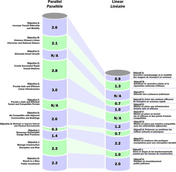
Bayview
Evaluation Summary
· “Direct
to Downtown” better serves the Regional transportation need.
· “Transfer
T” better serves the local accessibility and mobility criteria as well as
requiring less infrastructure and occupying less land.
New Text: Following the Public Open
House, refinements were undertaken to the "Direct to Downtown" to
reduce the station footprint. This alternative is the recommended option.
LeBreton
Evaluation Summary
·
“Bus/Booth At-grade Crossing” has fewer
infrastructure requirements but impacts the development of LeBreton Flats.
·
“Transit Under Booth” provides a good
long-term station with options to expand public space, connect to buildings or
provide additional tracks for flexible operation, and also impacts the
development of LeBreton Flats.
·
“Buses on Booth/Albert” has the fewest
infrastructure requirements and provides the best integration with NCC
development plans, but requires buses serving Gatineau to operate on-street.
Downtown
The further north the alignment:
·
The further north the catchment area.
·
More of the catchment area covers
Parliament Hill and beyond.
·
Businesses along Laurier and the
residential areas to the south are more difficult to access.
·
The more challenging it is to construct a
transit station under the Mackenzie-King Bridge.
The further south the alignment:
·
The further south the catchment area.
·
More of the catchment area covers the
developed areas of the downtown.
·
The closer Laurier and the residential
areas to the south are to the transit stations, but the higher the pressure to
redevelop those lands.
·
The more challenging it is to construct a
station under Rideau Street.
The Cross Country alignment connects:
·
Higher density development in the
southwest area of downtown.
·
High-density area and trip attractors in
the northeast area of downtown.
·
Local transit, the By-ward Market area
and the Rideau Centre at a station under Rideau Street.
Campus
·
All options score well in different
categories, and achieve similar total scores.
· Based
on additional work undertaken since the Public Open House, the “Portal South of
Mann” option is the recommended design alternative.
Hurdman
Evaluation Summary
·
Locating the rail station over top of the
bus facilities (to minimize passenger transfers) scores well.
·
Protecting ability to connect to the
southeast needs to be viewed in more detail.
Note:
Following the Public Open House, refinements were undertaken to
the "Horizontal Transfer" option to improve the connection between
LRT and buses. This design alternative is the recommended option.
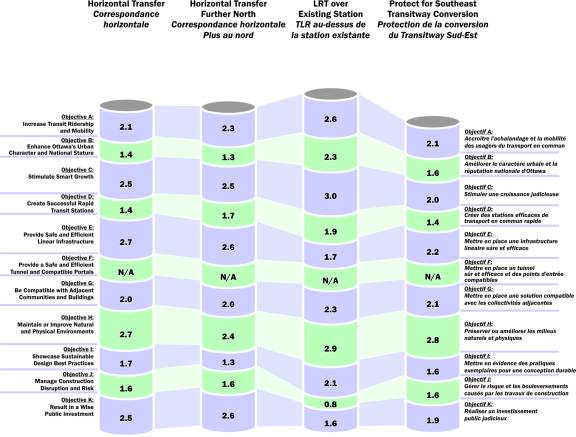
Train
Evaluation
Summary
· Straighter alignment scores well.
· “Diagonal” station with north and south access points improves local
connections
· Curved platforms in the “Re-use existing station” are not suitable
for long term train lengths.
· Curves are too sharp.
· Tangent segment is very short.
· This option is not being carried forward.
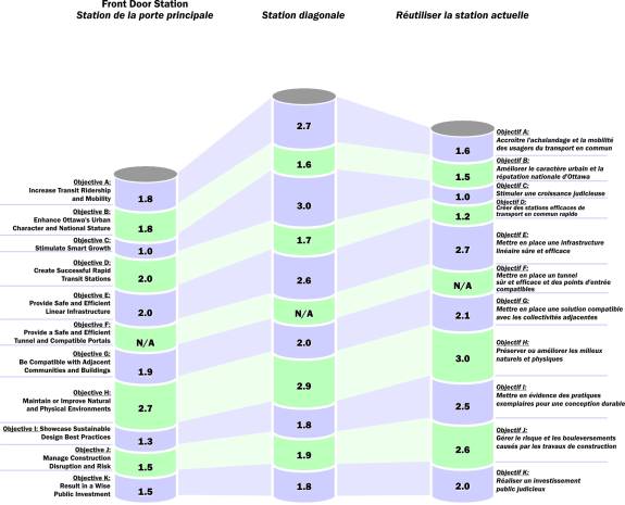
Blair
Evaluation
Summary
· LRT on upper level (existing BRT platform) re-uses the most existing
infrastructure but cannot provide sufficient bus platform and lay-by space for
the long-term
· LRT on lower level allows for a larger bus facility and easier
future extension to the east, but requires a large decked bus transfer area
· Locating the LRT platform further to the east allows better access
to existing development east of Blair, but increases internal circulation distances
and requires the same large decked bus transfer area
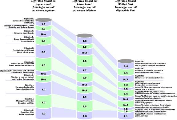
STATION CONFIGURATION AND PLATFORM DESIGNS DOCUMENT
3
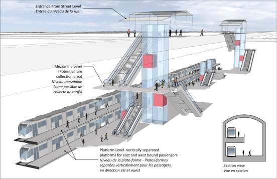
Stacked
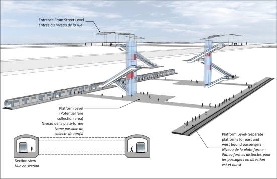
H-Shaped
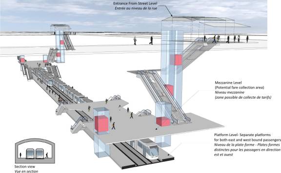
Side
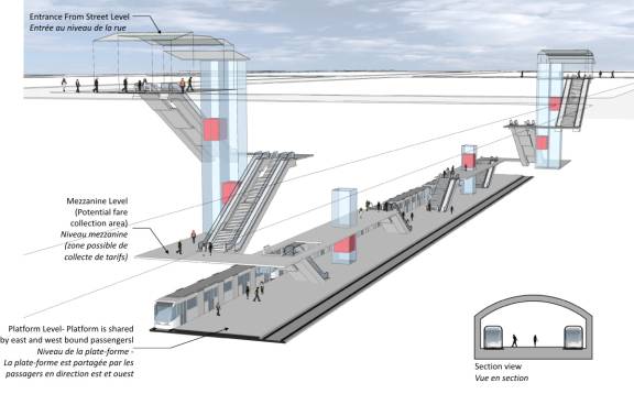
Centre
SUMMARY OF PUBLIC CONSULTATIONS DOCUMENT
4
|
Date
|
Consultation Type
|
Purpose
|
|
August 13, 2008
|
CEAA, MOE Co-ordination
Meeting
|
Project introduction and
EA co-ordination
|
|
August 21, 2008
|
ACPDR #1
|
Project introduction and
overview
|
|
September 9, 2008
|
ACG #1
|
Project introduction and
overview
|
|
September 9, 2008
|
BCG #1
|
Project introduction and
overview
|
|
September 9, 2008
|
PCG #1
|
Project introduction and
overview
|
|
October 29, 2008
|
ACG #2
|
Planning objectives,
alternative alignments and evaluation methodology
|
|
October 29, 2008
|
BCG #2
|
Planning objectives,
alternative alignments and evaluation methodology
|
|
October 29, 2008
|
PCG #2
|
Planning objectives,
alternative alignments and evaluation methodology
|
|
December 2, 2008
|
ACG #3
|
Introduce expanded study
area, draft evaluation results
|
|
December 2, 2008
|
BCG #3
|
Introduce expanded study
area, draft evaluation results
|
|
December 2, 2008
|
PCG #3
|
Introduce expanded study
area, draft evaluation results
|
|
December 16, 2008
|
PWGSC
|
Tunney’s Pasture Design
Alternatives
|
|
December 18, 2008
|
ACG/BCG/PCG Meeting
|
Project introduction and
overview for CG members in expanded study area
|
|
December 19, 2008
|
NCC
|
NCC input on alternative
designs
|
|
January 6, 2009
|
NAC
|
NAC input on downtown
alignments
|
|
January 21, 2009
|
ACG #4
|
Downtown stations,
alternative designs for expanded study area, maintenance and storage facility
overview
|
|
January 21, 2009
|
BCG #4
|
Downtown stations,
alternative designs for expanded study area, maintenance and storage facility
overview
|
|
January 21, 2009
|
PCG #4
|
Downtown stations,
alternative designs for expanded study area, maintenance and storage facility
overview
|
|
February 4, 2009
|
NCC
|
NCC Input on alternative
designs
|
|
February 18, 2009
|
Downtown Stakeholders
|
Alternative downtown
alignments, surface transit operations and additional station opportunities
|
|
February 26, 2009
|
ACPDR #2
|
Alternative alignments and
design options
|
|
February 26, 2009
|
Public Open House #1
|
Project introduction and
overview, alternative alignments and design options, draft evaluation results
|
|
March 26, 2009
|
Rideau Viking Corporation,
Rideau BIA
|
Alternative downtown
alignments and surface transit operations
|
|
March 27, 2009
|
Downtown Coalition
|
Alternative downtown
alignments and surface transit operations
|
|
March 27, 2009
|
University of Ottawa
|
Campus Station design
options
|
Downtown
Ottawa Transit Tunnel (DOTT) Planning and Environment Assessment Study Update
ÉTUDE DE
PLANIFICATION ET D'ÉVALUATION ENVIRONNEMENTALE DU TUNNEL DE TRANSPORT EN COMMUN
AU CENTRE-VILLE D'OTTAWA (DOTT) (RAPPORT PROVISOIRE) - TRACÉ DU COULOIR ET
CHOIX DES STATIONS
ACS2009-ICS-PLA-0069 CITY WIDE / À L'ÉCHELLE DE LA VILLE
Nancy Schepers, Deputy City Manager introduced the item and Vivi
Chi, Manager, Transportation and Infrastructure Planning and David Hopper,
Delcan provided a detailed overview of the report. Pat Scrimgeour, Manager, Transit Services Design spoke to the
operational issues and, Rob Mackay, Manager, Strategic Projects provided
details on process and other issues as they related to the report. A copy of their comprehensive PowerPoint presentation
is held on file.
The Chair received three Motions two of which would seek to defer
the report:
Moved by C.
Leadman (on behalf of Councillor Holmes)
That in
consultation with the Ward Councillor, staff investigate options with the goal
to minimize bus traffic along Albert Street as it passes through the Lebreton
Flats.
Moved by C.
Leadman
That the recommended alignment of
the downtown tunnel be deferred until costing is
developed and approved by Council;
And that staff develop and cost a second possible DOTT alignment
with grade separation under Albert Street, utilizing the existing
Mackenzie-King Bridge transit infrastructure, a grade separation (over/under
pass) at the Laurier intersection following the existing rapid transit network
route and utilizing the existing grade separated infrastructure adjacent to the
University of Ottawa.
Moved by G. Bédard
That ICS and Transit Services staff be directed to jointly
reconsider the report prior to any form of approval by Committee and Council
and develop, for the approval of Committee and Council, a Downtown Transit Plan
to address the following matters:
·
The absolute need for the continued
economic vitality and viability of the Rideau commercial district
·
The importance of transit service –
both access from all areas of the City and the details of operations – to
support this economic vitality and viability
·
The need for convenient connections
from the surface transit service to the underground light rail line
·
The need for continued transit
service to the stops on the Mackenzie King Bridge to maintain a pedestrian flow
through the Rideau Centre and nearby businesses
·
The need for substantial reductions
in the number of buses operating on Rideau Street and on Albert and Slater
Streets to improve the general environment on those streets and for businesses
along those streets
·
The need for continued reliable and
convenient transit service to, from, and through the Rideau commercial area and
all of downtown
·
The possible need for transit
priority measures or physical modifications to streets to allow the recommended
plan to be implemented
And that staff be directed to develop and bring forward
recommendations for the consideration of Committee and Council in time that any
required civil works can be included in the Downtown Ottawa Transit Tunnel
project.
WHEREAS staff are still developing alternatives for
surface transit operations during and following construction of the DOTT;
THEREFORE BE IT RESOLVED that in consultation with
the Ward Councillor, staff investigate options with the goal to minimize bus
traffic along Albert Street as it passes through the LeBreton Flats.
The Committee
received the following delegations:
David Jeanes, Transport 2000 made note
of the fact that compared to other cities in Canada, some of the downtown
stations are quite far apart. There is
also a long climb to the surface. He
suggested there be one or two more stations in the downtown. He further noted that all of the proposed
stations in the core are a long way from City Hall. He believed that the Daly Avenue alignment vs. Rideau Street was
not sufficiently studied and felt it would better serve the Rideau Centre. And, if none of this works, more attention
should have been paid to the surface option because a four-vehicle train would
provide the necessary capacity.
In response to a question of clarification by the Chair, staff
confirmed that the length between stations was to accommodate up to a maximum
of a six-car train.
Charles Akben-Marchand, Centretown Citizens' Community Association
(CCCA) presented the following concerns:
·
No transit on Scott and Albert
streets; alternatives include: in-road track between Tunney’s and Bayview
stations; extending the O-Train to Gatineau; and, using the Ottawa River
Parkway; express buses must turn around at Tunney’s Pasture
·
Number of downtown stations; the walking time is much higher than the current transitway
·
DOTT stations; the number of proposed stations limits the number of trains that
can serve the downtown and limits opportunities for multiple lines when LRT is
extended to suburbs; future LRT lines with lower passenger demand will use
shorter trains, but these will not be allowed in the downtown due to need for
capacity of six-car trains, esp. during rush hour
·
Bayview Station; Transfer “T” scored higher in analysis than “DTD” (direct to
downtown), but requires transfer downtown; DTD and T are operationally
different and therefore requires a look at how trains will run; north/south
passengers will have to transfer to six-car east/west trains at Bayview during
rush hour. There are two ways to solve
this: do not convert the O-Train; or,
have more and shorter stations downtown.
A copy
of his written submission is held on file.
When asked to comment on these concerns, specifically with respect
to the walking distance between stations and their depth, Mr. Hopper advised
that they are attempting to get them as shallow as possible, but he did not
have further details at this time. He
added that there will be a number of entrances to the stations throughout the
downtown, so although the stations are far apart, there are many accesses to
them. They have to ensure an
appropriate balance of portals and stations.
Cindy VanBuskirk, General Manager, Rideau Centre spoke to a prepared statement, the more salient being as follows:
·
Transit is an integral part of the
community infrastructure and has the potential to be both a positive and
negative for the Rideau Centre; 47% of their customers come by transit
·
The Rideau Centre complex was built to
revitalize the ByWard Market and Rideau Street by providing a pedestrian flow;
it also functions as a transit hub linking local transit service on Rideau
Street with regional transit service on the Mackenzie King Bridge; the
development agreement with the City of Ottawa required them to provide transit
access for 20 hours each day
·
To facilitate this transit customer
movement through the shopping centre, the design and merchandising followed a
north-south orientation between Level 1 and Level 3; however, the proposed
Rideau Street tunnel alignment will permanently remove all regional and express
transit traffic from the Mackenzie King Bridge, thereby eliminating that
transit customer movement; in turn, this will reduce overall customer traffic
and severely reduce sales volumes and productivity
·
If the main objective of the transit
tunnel project is to move people quickly and efficiently to and through
downtown Ottawa, this can be just as easily achieved following a Mackenzie King
Bridge alignment, without the devastating impact on the Rideau Centre and it’s
retailers; proceeding with the Rideau Street alignment at the expense of Rideau
Centre’s continued success is harmful to everyone
In
conclusion, Ms. VanBuskirk asked the Committee to send the Downtown Ottawa
Transit Tunnel report back to staff and the project team, with direction to
more comprehensively and conclusively address these concerns in the context of
an overall transportation and development plan that will better support all
interests. A copy of her written
submission and a previously distributed letter to the Deputy City Manager dated
21 April 2009 is held on file.
When asked to respond to the
suggestion of access via the Mackenzie King Bridge, Ms. Chi explained that
staff did examine that option but explained that the turn at that location
would result in having to move the Campus Station further east. There are pilings under the University of
Ottawa buildings that would be affected.
Mr. Hopper added that the entire structure is on piles so the tunnel
would have to be of a specific depth to avoid those. Also, the curve would be too sharp. He indicated that there are strong technical challenges to doing
this as well as where it would come up at the Rideau Centre. The north side affords more opportunities to
connect to amenities. They recognized
the economic issues raised by the delegation.
Councillor Bédard inquired how
seriously staff looked at this because he felt it was not really
investigated. Mr. Hopper explained that
detailed evaluation criteria were used for all options. He offered that many buildings had piles
underneath and so while it could be built to the bridge instead, it would be
expensive. Further, all alignments on
Rideau Street had the least risk.
The councillor stated that none of
the criteria had to do with commercial or economic development and the impact
on existing facilities. Mr. Hopper
explained that there were actually a number of criteria regarding sustainable
communities and smart growth, as well as several sub-criteria that addressed
this. The councillor emphasized
however, that none of the criteria looked at the economic impact on the Rideau
Centre. With regards to the issue of
the criteria, the councillor presumed the consultant looked at the possibility
of the curve and whether or not it was feasible. Mr. Hopper responded by stating that the curve from the Mackenzie
King Bridge to Nicholas Street would be impossible with the tunnel-boring
machine and a “cut and cover” design would be the other way to do it.
In response to a question posed by
the councillor, Ms. VanBuskirk advised that there is already a transit station
at the Mackenzie King Bridge immediately inside and this platform is leased to
the City until 2024. With this
information, Councillor Bédard asked why a serious look would therefore not be
given to the Mackenzie Bridge and Mr. Hopper explained that the passenger
platform is only part of the equation and there are other things that have to
be balanced off.
Ms. VanBuskirk indicated that
Viking-Rideau support LRT and the TMP.
She reminded Committee members that their complex includes the Westin
Hotel, the Congress Centre, parking, shopping, et cetera and it would be a
colossal mistake not to seriously consider the impact this report has on this complex. They are prepared to lose pedestrian traffic
with the introduction of LRT, but putting all the traffic on the north side of
the building does nothing to support the merchants on Levels 1 and 3. There is a need to generate cross traffic to
support the economic viability of the Rideau Centre and without such traffic,
they would probably close their doors to business shortly after retail hours.
Councillor Legendre was quite
surprised by the position of the Rideau Centre and the fact they did not want a
new LRT system at their front door. Ms.
VanBuskirk advised that many of the retailers would be happy to have it, but
others would not because of their inability to draw traffic to their location. While the councillor posited that the
ability to attract commerce would remain, Ms. VanBuskirk indicated that there
would always be people shopping, but suggested the sales levels would not be
the same. The councillor wondered
whether the original development agreement was still in effect and wondered if
the legal ramifications have to be given in camera. Tim Marc, Senior Legal Counsel advised that
there is no legal obligation to the City to maintain transit service at the
Rideau Centre.
Councillor Leadman asked whether the
delegation had had meetings with City staff to discuss their concerns and Ms.
VanBuskirk explained that staff heard their concerns, but there did not seem to
be any option offered to address those concerns. She indicated that she has had discussions with staff about
putting investment in an underground tunnel station, but she did not think
those discussions have progressed to the point where they could participate in
the ultimate tunnel program. The
councillor asked whether Ms. VanBuskirk believed the Rideau Centre was a
major employment centre and the delegation indicated she did, adding that the
Rideau Centre has 3300 employees. The
councillor noted therefore, that the Rideau Centre is a substantial employment
hub, which the Committee should keep in mind as opposed to looking at it from a
perspective of supporting business.
When asked by Councillor Bédard what
the pedestrian traffic was like through the Ridau Centre, Ms. VanBuskirk
indicated they receive about 20 million people each year. If the transit hub were cut off, it would
have a devastating impact. She related
that during the recent transit strike, their daily traffic declined to 40% and
with about 30,000 fewer people, their sales declined and many millions of
dollars were lost in January. When
asked what the economic impact of that was on the City, she advised that
reduced sales would mean a reduction in property taxes to the City. There would probably be fewer retail
businesses at the Rideau Centre as well.
As well, their ability to attract world-class businesses would decline. She agreed that the Motion the councillor
was putting forward was important because it would give them something to look
at to fully understand what the impact will be on the Rideau Centre.
Hume Rogers, Downtown Coalition spoke
with Pat Gillen, on behalf of the 35 building owners and managers of the Coalition, which represents 81
office buildings and hotels. They were
pleased to see the planning of the downtown tunnel moving forward because it
will contribute positively to the capacity, speed, efficiency and ridership of
public transit. The tunnel will remove
all but local buses from Albert and Slater, improving safety and environment in
the downtown. However, they requested
that these benefits not be destroyed by moving the STO buses to these streets.
They agreed with the staff recommendations, including the number of
stations, but believed the consultant’s proposal places the most easterly
station in the core too far north, whereas there is a much greater population
to be served south of Queen and Albert.
Instead of
veering cross-country to the north at Kent Street, they suggested it continue
to the east along the line of Albert Street and then cut north at Metcalfe
Street, placing the most easterly station along Albert instead of Queen. This would increase the number of people
within a 300m catchment area of the station by approximately 14% and would
provide better service to City Hall, the Courthouse, and Place Bell. Future growth in the core will expand to the
south along Slater, Laurier and beyond, therefore, keeping as far to the south
at the most easterly stop is desirable for that future expansion.
The Coalition made this suggestion
to the consultants, but do not believe they have taken an objective look at it,
stating it would lead to a slightly sharper curve than the one proposed. He pointed out, however, that the proposed
curve from Rideau to Waller in a southerly direction is much more severe. Their proposed variation will not have an
impact on the NAC or the Bell Canada switching station. A copy of his written submission is held on
file.
Responding to questions of
Committee members, Mr. Gillen indicated that the bend at the Rideau Centre is
much sharper to the west than what they have proposed because they suggest the
curve start at Metcalfe Street. And,
with the latest technology, he understood that the curve they propose is
acceptable.
Mr. Hopper
indicated that they had reviewed the curve in their proposal and the version he
has more accurately reflects what is needed to make the alignment work. Their version does not allow for a station
on Rideau Street, whereas the proposed option shows a station spanning across
to the Canal. And, they have to get
past the station before starting the curve and that it why the curves are sharper. The councillor recognized that the bends in
both curves are the same, but it is the sharpness of the curves west of the
Canal that is the problem. The
consultant concurred with this assessment.
John Walker suggested that due to the
financial situation in the world, the funding from the senior level of
government may be less than anticipated and suggested that the expectation of
them paying one third of the cost for this project may not be fulfilled. He proposed a less expensive “Plan B”.
He recognized the advances in bus hybrid technology, including the
use of ultra capacitors that can be charged in a few minutes and which hold
quite a bit more power then batteries.
This would mean travelling several 10s of kilometres on a short quick
charge, which is a lot cleaner than diesel.
He made reference to the new technology available for clean, efficient
hybrid buses, which are preferred over light rail and which do not constrain
the system to wires or rails.
He cautioned about changing to a different system, because when the
City starts to add in light rail, passengers will have to wait for a
train. Also, the depth of the tunnel,
plus the waiting time for a train may add 20 minutes to a person’s overall trip
time. Given the success of the existing
transit system, Mr. Walker did not believe there were any advantages to using
light rail, a system that will cost twice as much and has many limitations.
He suggested that instead of having deep tunnels, have a
cut-and-cover system instead which will place them no more than three or four
metres underground and buses can easily enter the transit system with simply a
grade going down into the tunnel. He
also suggested changing the Mackenzie King Bridge to a two-level bridge. A copy of his written submission is held on
file.
Derek Reid, Action Sandy Hill suggested
variations for stop locations of the stations, which he believed, warranted
consideration. These included:
Westboro – would be relatively
inexpensive; the reduced costs of running trains instead of buses along this
corridor justifies implementing the extension to Westboro in Phase 1. Local residents will not tolerate transitway
buses using Scott Street and a suitable and unintrusive bus terminal can be temporarily
located directly north of Westboro Station.
There would no longer be justification for running buses all the way
downtown or to Lebreton or Bayview.
Tunney’s Pasture – extending it to
Westboro would eliminate the need for expanding the bus terminal at Tunney’s
Pasture; removing the transitway access ramp would free up space and enable
redevelopment of the land.
Bayview – shifting the Bayview Station
to the west would provide better access to Bayview Road and would preserve a
transfer option for a north/south LRT route.
Preston – shifting Lebreton Flats
Station to the west would improve access to Little Italy and would maintain
walkable access to the War Museum; having LRT access to Preston Street, a main
commercial street, makes sense.
Mr.
Reid ran out of time before completing his presentation on Bronson Park, Bank,
Bank to Rideau, Centretown, Rideau and Campus and Lees. Additional details are contained in his
written submission, which is held on file.
Peggy DuCharme, Downtown Rideau BIA
indicating she was also speaking on behalf of residents, the ByWard Market BIA,
Arts Court and Giant Tiger, who were unable to stay for the duration of the
meeting. Ms. DuCharme indicated that
their Task Force concluded that regional and local transit should remain on
separate corridors in their district, with regional (future LRT) remaining on
the existing “regional” transitway corridor on the Mackenzie King Bridge. She noted that this corridor was originally
designed and built for this purpose, as was the Rideau Centre. Removal of the Mackenzie King Bridge as a
transit hub will disrupt the pedestrian traffic patterns in the immediate area
and will have serious negative economic impact on several businesses located on
the southern border of their boundary. Further,
they do not support the recommendation to locate all local, regional and
interprovincial transit onto Rideau Street as this would place far too great a
burden on Rideau Street which has already surpassed capacity and would
jeopardize the street’s economic potential and ability to remain accessible to
all modes of traffic in the future. A
copy of her letter to staff dated 21 April 2009 is held on file.
Responding to a series of questions as a result of this
presentation, Ms. Schepers advised that staff recognize that the Rideau Centre
and the operation of Rideau Street is an important part of how the Rideau
Centre operates and there is an opportunity with the proposed alignment to
reduce traffic on Rideau Street. With
respect to connecting to the Rideau Centre or to other locations, staff do not
have any assurances from the private sector that the City will have those
rights of access, but one of the recommendations before Committee is for staff
to seek interest from the private and public sectors with respect to where
there may be opportunities. She added
that there was never a guarantee that transit service would continue on the
bridge. When asked if there would be
fewer buses on Rideau Street, staff advised that there would be and staff would
explore more fully what that might look like because it frees up infrastructure
on the Mackenzie King Bridge as well.
She confirmed that Rideau Street is an important urban space in the
community and the opportunities to invigorate it are here.
Ms. DuCharme responded to questions posed by Councillor Bédard by
advising that they have an extensive knowledge of the community and work
stringently on developing relations and are concerned about having that
jeopardized. In this regard, she
supported Councillor Bédard’s Motion that directs staff to look at those and
other concerns.
Councillor Legendre thought that a reduction in buses on Rideau
Street would have been welcomed by the BIA.
Ms. DuCharme explained that the issue she had was how the City plans to
reach its transit growth objectives with less buses to bring to transfer onto
the regional system? Also, she believed
there are other areas of potential exploration on that alignment and she
suggested the station could open up near Arts Court, for example and still
provide the portal on Rideau Street (to the Rideau Centre’s existing transitway
station platform), et cetera.
Councillor Bédard recognized that the delegation had concerns of
where the entrances and exits will be along that line and Ms. DuCharme
confirmed this, adding that there is more density south of their boundary and
she was very confused as to the portals opening up over at the Conference
Centre because there is nothing there.
She noted that the same reasons for rejecting the Wellington alignment
apply to that same location at Rideau/Sussex.
She was also concerned how transit would be rerouted if there were
demonstrations that require detours from Rideau/Wellington streets.
To staff, the councillor stated that if one of the criteria is to
stimulate smart growth and to go to where the people are, having heard what the
BIA has said, he asked why the consultant insists that the access be at Rideau
Street? Mr. Hopper explained that one
of the factors for selecting an entrance adjacent to the Train Station
(Conference Centre) is that is the ‘historical capital arrival’ and it
faces the whole of the area. They also
had to consider how many people visit these areas and the fact that that
station has many other potential connections to a very large area that stations
further south do not have.
After hearing the complaints from the delegation, Councillor Bédard
inquired whether staff should be pursuing the questions addressed in his
Motion. Ms. Schepers indicated that the
issues raised in the Motion need to be addressed and she agreed those could be
seen as direction to staff for consideration and reporting back during the next
phase of the functional design. On that
basis, the councillor indicated he would, in consultation with staff, rephrase
his Motion.
John Courtneidge suggesting amending
Recommendation 2 to insert the words “occupiers and users” after the words
“property owners”. He believed that the
surface rail system is much better for businesses and the community. He was quite concerned about the cost of the
project. He provided a copy of his
written notes, a copy of which is held on file.
The Chair explained that the debate about whether or not to move
forward on this project are not before the Committee today as the technology
has already been decided. He explained
that the transit system is at capacity and the City is building for growth.
Councillor Legendre asked staff to comment on the amendment proposed
by the delegation. Ms. Schepers advised
that the idea is to unilaterally seek partnerships. Staff would be very specific to go to land owners and she
suggested that if the Committee wanted to open it up, staff would do so, in
order to solicit additional proposals and ideas.
Responding to a question posed by Councillor Doucet, Mr. Hopper
advised that there are a number of benefits to being grade separated through
the downtown, including an improved reliability factor, which is more important
than speed. Currently, at the suburban
stations, more people transfer on and off and if they are doing that it is
already convenient for them and while there may be a minute or two difference
with a train, there will be a speed benefit because of the elimination of
congestion in the downtown. Also, the
train will allow boarding at every door and will be faster. He acknowledged that it would take time to
get in and out of the stations compared to a bus now, but it will be a much
better environment for passengers waiting for a transfer to happen.
Councillor Doucet asked whether any studies have been conducted
about how someone would get from point A to point B and would they be better
off than they are today?
Ms. Schepers stated that they had looked at the potential
timesavings for passengers and the issue centres on existing capacity and
constraints in the downtown. She
indicated there are 180 buses an hour travelling through the downtown and the
only way to grow ridership is to get as many people on them as possible. Staff are resolved in their ability to grow
transit ridership. She confirmed this
system would be faster for users and will save time. She agreed to follow-up with the councillor and provide him with
the work that was done as part of the TMP, before this report rises to Council
on 27 May.
David Gladstone, Friends of the O-Train
did not see any value in what is being proposed in the report and believed this
project will cause incredible disruption in the existing transit system. He offered that Ottawa has a strong
transit-oriented downtown and the office buildings are not built to connect to
the underground tunnel, but to surface transit. He did not believe that what is being proposed is compatible with
the Official Plan.
In considering the report, Councillor Leadman noted the increased
cost of the project and Mr. Hopper indicated that the figures developed in the TMP
include a substantial contingency (because of this study) and while staff are
now more certain, they do not know if it will cost much more. The councillor noted the route may affect
Public Works Canada and she wondered if staff anticipate any concerns being
brought forward from this agency. Ms.
Schepers indicated that Public Works have been a part of the consultation and
are aware of where the route is going.
Councillor Leadman had a series of questions regarding the existing
infrastructure. She noted that what is
being recommended is not a traditional transit system and Council does not have
the information with respect to what the impacts will be. She found it difficult to make a valid
assessment without that information, as well as only going ahead with one
alignment.
Councillor Wilkinson was in support of the staff report, but was
concerned about buses coming from the west.
She noted that some people will be changing to a bus to go to Gatineau
or to the O-Train and suggested the transfer point be at Lebreton instead. Mr. Scrimgeour explained that staff
would be looking at travel patterns of riders once a decision is made on
station locations and alignment. The
councillor interjected however, that if they are going to do that based on
something that is conceptual, then she preferred staff bring forward a report
on a Lebreton option. The Manager
explained they would look at all options to determine what is best for all
transit customers. The councillor
indicated she would be putting forward a Motion that would seek to have the
terminal for buses coming from the west at Lebreton.
Councillor Doucet inquired what the affects of the tunnel would be
on intensification and growth management in the downtown and was advised by the
Deputy City Manager that the TMP is a fundamental element of the Official Plan
and in order to achieve the overall plan all systems (transit, land uses, et
cetera) are all connected to the achievement of the TMP. The project before the Committee today is
supportive of Council being able to achieve TMP intensification targets
throughout. There will be a significant
impact overall on how people use the system and also where they choose to live,
work, et cetera. The councillor
wondered what the local impact would be if it has little or no impact on those
targets. Ms. Schepers advised that
Recommendation 2 directs staff to solicit ideas and the TMP has targets
specifically around the transit nodes and that will be a target as they move forward. The uplift in terms of being able to extract
that value and potentially use it is something staff will be soliciting over
the next phase. Mr. Mackay added that
the Investment Strategy work currently underway with the City’s consultant
KPMG, is looking at the whole matter of uplifting and staff will report back to
the Committee in June on that, the intent being to determine interest then
enter into a memorandum of understanding before this project actually gets
funded.
In response to a further question posed by the councillor, Mr.
Mackay advised that from benchmarking in other cities, and while it takes time,
intensification improvement does occur around the stations. He assured the councillor that in time,
Council will see positive impact happening around the stations with regards to
new commercial services and intensification.
He confirmed that staff have been in discussions with some of the
business community and they are quite interested in this project.
Councillor Leadman inquired what challenges there might be that
could change the recommended transfer point being Tunney’s Pasture? Mr. Hopper indicated that they have done a
fair amount of work at that location and they feel it can handle the volumes
anticipated. The councillor thought
that if there was an option of doing it at Lebreton, why would not that be done
right from the start? Mr. Scrimgeour
indicated that it is a facility that is needed for the period of time when
light rail is built to Tunney’s Pasture and light rail is built further west.
In speaking to her Motion, Councillor Leadman stated that while
people appear to have bought into an alignment, she still maintained there were
a lot of unanswered questions and she questioned how she can be made to feel
comfortable about making this decision, without first having all the unanswered
questions dealt with.
Councillor Bédard suggested the Motion be divided for
voting purposes. He recognized that the
costs for this project are huge and agreed that the second action portion of
the Motion makes sense because he felt the Mackenzie King Bridge alignment is a
good option.
Councillor Wilkinson inquired what would be involved
in getting that costing and was advised by Mr. Hopper that they would have to
do a functional plan on that alignment, which would increase the scope of the
work, et cetera. Ms. Chi added that it
would add several months to this process.
She confirmed that this alignment had been examined and the consultant
had discussed some of the challenges during his presentation.
Chair Cullen understood that additional costing could
not be obtained without an alignment, but to support a request for another
option would further delay the project and increase costs. He stated that the purpose of this is to
deliver residents to their destination as quickly and reliably as
possible. What is proposed will alter
the downtown and removing transitway buses from the core will make it better
for pedestrians and cyclists.
Councillor Leadman explained that the initial
alignment was designed by staff and therefore, if that work has already been
done, she did not think the delay would be substantial. Speaking to the report in general, she
recognized the importance of the Rideau Centre because it is a significant
employment centre and the reduced transit elements will create a significant,
negative impact on them. She reminded
Committee to consider the report with regards to how it will be serving the
whole city.
As requested by Councillor Bédard, the Committee then
voted on the Motion as follows, with recorded votes for the two action
portions:
Moved by C. Leadman:
WHEREAS the proposed
alignment for the Light Rail project, as part of the Transportation Management
Plan (TMP) significantly varies from the original alignment;
AND WHEREAS the downtown
tunnel is the lynchpin of the TMP and must be financially viable and the
proposed route alignment could significantly increase the cost for the capital
project;
AND WHEREAS the cost is
not currently known by staff for the proposed Downtown Ottawa Transit Tunnel
(DOTT) Corridor and Station Alignment but will be available in an estimated two
months;
AND WHEREAS the proposed
alignment has and will raise particular concern from several prominent
stakeholders;
THEREFORE BE IT RESOLVED
THAT the recommended alignment of the downtown tunnel be deferred until costing
is developed and approved by Council;
LOST
YEAS (2): C. Leadman, C.
Doucet
NAYS (6): R.
Bloess, G. Bédard, J. Legendre, D. Thompson, M. Wilkinson, A. Cullen
AND BE IT FURTHER RESOLVED
THAT staff develop and cost a second possible DOTT alignment with grade
separation under Albert Street, utilizing the existing Mackenzie King Bridge
transit infrastructure, a grade separation (over/underpass) at the Laurier
intersection following the existing rapid transit network route and utilizing
the existing grade separated infrastructure adjacent to the University of
Ottawa.
LOST
YEAS (3): G. Bédard, C.
Leadman, C. Doucet
NAYS (5): R. Bloess, J.
Legendre, D. Thompson, M. Wilkinson, A. Cullen
On
behalf of Councillor Holmes, Councillor Leadman proposed that in consultation
with the Ward Councillor, staff investigate options with the goal to minimize
bus traffic along Albert Street as it passes through the Lebreton Flats.
Councillor
Legendre felt it would be better to assign a number (percentage) to the Motion
and suggested the Motion be amended to include: “a reduction of bus traffic by no more than 30%”. The Chair explained that the purpose of this
particular Motion is to consult with the ward councillor and that no target was
required. Councillor Leadman did not
accept it as a friendly amendment and the Committee took a separate vote on
Councillor Legendre’s amendment.
Moved
by J. Legendre
WHEREAS staff are
still developing alternatives for surface transit operations during and following
construction of the DOTT;
THEREFORE BE IT RESOLVED that in consultation with the Ward
Councillor, staff investigate options with the goal to reduce bus
traffic by no more than 30% along Albert Street as it passes through the
Lebreton Flats and report back to Transit Committee.
LOST
YEAS (2): J. Legendre, D. Thompson
NAYS (6): R. Bloess, G. Bédard, C. Leadman, C. Doucet, M. Wilkinson, A.
Cullen
Councillor Wilkinson suggested and Councillor Leadman accepted as a
friendly amendment, the addition of the phrase: “and report back to the Transit Committee” at the end of the
Motion.
Moved by C.
Leadman
WHEREAS staff
are still developing alternatives for surface transit operations during and
following construction of the DOTT;
THEREFORE BE IT RESOLVED that in consultation with the Ward
Councillor, staff investigate options with the goal to minimize bus traffic
along Albert Street as it passes through the Lebreton Flats and report back to
the Transit Committee.
CARRIED,
as amended
Prior to considering Councillor Bédard’s
Motion, the councillor distributed a revised text, which removed some wording,
including the initial intent to defer.
He encouraged Committee members to support his Motion.
While he would support the bulk of the
Motion, Councillor Legendre requested a separate vote for the fourth bullet
because he could not support the language used and did not believe that was the
purpose of the transit system.
Councillor Wilkinson was concerned about how the fourth and fifth
bullets fit into each other and suggested there was a need for some
follow-through until the transitway is completed. She wanted staff to look at those two together so Council can be
advised what the impact will be on passengers coming through there. She maintained that transit is an important
element for improving economic development.
Councillor Doucet stated that transit should be on the surface
because it animates the street. To put
it underground will make it further for people to have to go to get their
transfer.
As requested by Councillor Legendre, the Committee
then voted on the Motion as follows, with a recorded vote for bullet 4:
Moved by G. Bédard
WHEREAS the Rideau Centre, the Government of Canada Conference
Centre, ByWard Market access, Rideau Street Merchants, Ottawa Convention
Centre, nearby hotels and offices and many other businesses comprise a Rideau
commercial district;
AND WHEREAS the planning and construction of the underground light
rail line will make it necessary to re-examine surface transit operations in
downtown Ottawa;
AND WHEREAS the detailed design of the stations on the underground
light rail line requires certainty as to the service design for surface transit
operations in their vicinities;
AND WHEREAS the Rideau Centre complex has benefited from a
significant level of cross commuter traffic between Rideau Street and the
Mackenzie King Bridge;
AND WHEREAS the owners of the Rideau Centre complex are concerned
that the proposed alignment will negatively impact the financial viability of
their tenants;
AND WHEREAS the Downtown Rideau Business Improvement Area has
requested that the level of local and interprovincial transit service operating
on Rideau Street be reduced;
AND WHEREAS there has been significant investment in public transit
infrastructure in the downtown core, particularly in the Rideau commercial
district;
AND WHEREAS revised surface transit operations may require the
reconfiguration of streets and other physical facilities and may influence the
design of the Downtown Ottawa Transit Tunnel project;
THEREFORE BE IT RESOLVED THAT Transit Services staff be directed to
develop for the approval of Committee and Council a conceptual transit plan for
surface operations;
AND BE IT FURTHER RESOLVED THAT the following principles be incorporated
into the terms of reference of the plan:
·
The recognition of the continued
importance of preserving the economic vitality and viability of the Rideau
commercial district
·
The importance of transit
service – both access from all areas of the City and the details of operations
– to support this economic vitality and viability
·
The need for convenient
connections from the surface transit service to the underground light rail line
·
The need for continued transit
service on Mackenzie King Bridge to maintain a pedestrian flow through the
Rideau Centre and nearby businesses and to maximize existing infrastructure
investment
CARRIED
YEAS (6): R. Bloess, G.
Bédard, C. Leadman, C. Doucet, M. Wilkinson, A. Cullen
NAYS (2): J.
Legendre, D. Thompson
·
The need for substantial
reductions in the number of buses operating on Rideau Street and on Albert and
Slater Streets to improve the general environment on those streets and for
businesses along those streets
·
The possible need for transit
priority measures or physical modifications to streets to allow the recommended
plan to be implemented
AND BE IT FURTHER RESOLVED THAT the conceptual transit plan be
placed before Transit Committee with the tabling of the Downtown Ottawa Transit
Tunnel functional design in August 2009.
CARRIED
Moved by J.
Legendre:
That in consultation with the Ward Councillor, staff
investigate options with the goal to minimize bus
traffic along Albert Street as it passes through the LeBreton Flatsprovide a
report to Council which explains how the Transit system will be kept
operational during construction of the DOTT by the Fall of
2009.
CARRIED
In considering the Motion put forward by Councillor Wilkinson
previously with regards to having the terminal for buses at Lebreton, the
councillor felt that Council needed to know whether the impact on the buses is
the same and suggested her Motion could serve as an addendum to Councillor
Bédard’s Motion so staff could respond at the same time.
When asked to provide a staff comment, Ms. Schepers recognized the
challenges posed by using Lebreton because it is federally owned. She suggested if it were something staff
were directed to examine, they would also have to look at minimizing the number
of transfers and overall cost too. With
that in mind, going to Tunney’s Pasture is more attractive and is what people
will want to do. She noted that when
the transfer facility is moved further east, it changes the operation of the
train system and this will be a trade off and will require further analysis and
a report back with recommendations.
The Chair asked whether the issues raised in the Motion are going to
come back to the Committee in any case and Ms. Schepers advised this would be
the case. The Chair could not support
the Motion, stating that Council has already chosen an alignment and Tunney’s
Pasture is the interim western transfer point until Council decides how to
proceed further with the western corridor.
He did not want to cause confusion for the public by bringing in
Lebreton as a transfer point.
Councillor Wilkinson agreed to withdraw her Motion in favour of
working with staff with the intention of bringing something forward at Council.
That Transit Committee recommend Council:
1. Approve the recommended corridor alignment and station options
for the Downtown Ottawa Transit Tunnel (DOTT) Planning and Environmental
Assessment Study.
2. Direct staff to
release a Request for Information (RFI) to property owners within and adjacent
to the recommended corridor alignment to solicit ideas on station access,
development, design, and other matters with the aim of improving ridership,
ridership experience and lowering City costs.
3. That in consultation with the Ward Councillor, staff investigate
options with the goal to minimize bus traffic along Albert Street as it passes
through the Lebreton Flats and report back to Transit Committee.
4. That Transit Services staff be
directed to develop for the approval of Committee and Council a conceptual
transit plan for surface operations;
And
that the following principles be incorporated into the terms of reference of
the plan:
·
The recognition of the continued
importance of preserving the economic vitality and viability of the Rideau
commercial district
·
The importance of transit
service – both access from all areas of the City and the details of operations
– to support this economic vitality and viability
·
The need for convenient
connections from the surface transit service to the underground light rail line
·
The need for continued transit
service on Mackenzie King Bridge to maintain a pedestrian flow through the
Rideau Centre and nearby businesses and to maximize existing infrastructure
investment
·
The need for substantial
reductions in the number of buses operating on Rideau Street and on Albert and
Slater Streets to improve the general environment on those streets and for
businesses along those streets
·
The possible need for transit
priority measures or physical modifications to streets to allow the recommended
plan to be implemented
And
that the conceptual transit plan be placed before Transit Committee with the
tabling of the Downtown Ottawa Transit Tunnel functional design in August 2009.
5. That in consultation
with the Ward Councillor, staff investigate
options with the goal to minimize bus traffic along Albert Street as it passes
through the LeBreton Flatsprovide a report to Council which explains how
the Transit system will be kept operational during construction of the DOTT by the Fall of
2009.
CARRIED,
as amended with Councillor Bédard dissenting