|
3. bronson
avenue In-Service road safety review examen interne de la sécurité
routière sur l’avenue bronson |
committee
recommendations
That
Council approve:
1. That
staff finalize the implementation of all low, medium and high cost strategies
identified in the report;
2. That
the northbound curb lane on Bronson Avenue on the approach to the Colonel By
Drive off-ramp be designated as right turn only;
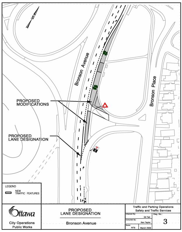
3. That
the proposed roadway modification, as shown in Document 3, be constructed to
physically prevent northbound motorists on Bronson Avenue in the curb lane on
the approach to the Colonel By Drive off-ramp, from proceeding through this
right-turn lane;
4. That
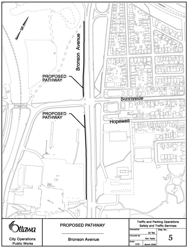
in 2009, staff undertake the preliminary design for an asphalt pathway, as
shown in Document 5, on the west side of Bronson Avenue, between Colonel By
Drive and Brewer Way, as outlined in this report; and,
5. That the funding required to undertake
the safety improvements for an asphalt pathway on the west side of Bronson
Avenue, between Colonel By Drive and Brewer Way, be included for consideration
in the draft 2010 budget.
Recommandations
du comité
Que le Conseil approuve, ce qui
suit :
1. Que le personnel finalise la mise en œuvre de toutes les
stratégies de coûts faibles, moyens et élevés désignées dans le rapport;
2. Que la voie en bordure en direction nord de l’avenue
Bronson, à l’approche de la bretelle de sortie de la promenade Colonel By, soit
conçue comme une voie de virage à droite seulement;
3. Que la modification du chemin proposée, comme le montre le
document 3, soit aménagée de façon à
interdire physiquement les automobilistes qui circulent en direction nord sur
l’avenue Bronson à l’approche de la courbe menant à la bretelle de sortie vers
la promenade Colonel-By de prendre la voie de tourne-à-droite;
4. Que le personnel entreprenne en 2009 la
conception préliminaire d’un sentier asphalté du côté ouest de l’avenue
Bronson, entre
la promenade Colonel-By et la voie Brewer, comme le montre le document 5, tel que mentionné
dans le présent rapport;
5. Que le financement nécessaire aux améliorations de la sécurité d’un
sentier asphalté du côté ouest de l’avenue Bronson entre la promenade Colonel-By et la voie
Brewer soit inclus afin d’être pris en compte dans les prévisions budgétaires
de 2010.
Documentation
1. Deputy
City Manager’s, City Operations report dated 1 April 2009 (ACS2009-COS-PWS-0007)
.
Report to/Rapport au:
Transportation Committee
and Council/ et au Conseil
1 April 2009 / le 1 avril 2009
Submitted by/Soumis par:
Steve Kanellakos, Deputy City
Manager/Directeur municipal adjoint
City Operations/Opérations municipales
Contact/Personne
ressource:
John
Manconi, General Manager/directeur générale, Public Works/Travaux publics
613-580-2424, extension 21110, John
Manconi@ottawa.ca
|
River/Rivière (16), Capital/Capitale (17) |
Ref N°: ACS2009-COS-PWS-0007 |
|
SUBJECT: |
bronson avenue IN-SERVICE road safety review |
|
|
|
|
OBJET: |
examen interne de la
sécurité routière sur l’avenue bronson |
REPORT RECOMMENDATIONS
That
Transportation Committee recommend and Council approve:
1.
That staff finalize the implementation of all low,
medium and high cost strategies identified in the report;
2.
That the northbound curb lane on Bronson Avenue on the
approach to the Colonel By Drive off-ramp be designated as right turn only;
3.
That the proposed roadway modification, as shown in
Document 3, be constructed to physically prevent northbound motorists on
Bronson Avenue in the curb lane on the approach to the Colonel By Drive
off-ramp, from proceeding through this right-turn lane;
4.
That in 2009, staff undertake the preliminary design
for an asphalt pathway, as shown in Document 5, on the west side of Bronson
Avenue, between Colonel By Drive and Brewer Way, as outlined in this report;
and,
5.
That the funding required to undertake the safety
improvements for an asphalt pathway on the west side of Bronson Avenue, between
Colonel By Drive and Brewer Way, be included for consideration in the draft
2010 budget.
RECOMMANDATIONS DU RAPPORT
Que le Comité des transports recommande,
et que le Conseil approuve, ce qui suit :
1.
Que
le personnel finalise la mise en œuvre de toutes les stratégies de coûts
faibles, moyens et élevés désignées dans le rapport;
2.
Que
la voie en bordure en direction nord de l’avenue Bronson, à l’approche de la
bretelle de sortie de la promenade Colonel By, soit conçue comme une voie de
virage à droite seulement;
3. Que
la modification du chemin proposée, comme le montre le document 3, soit aménagée de façon à interdire physiquement
les automobilistes qui circulent en direction nord sur l’avenue Bronson à
l’approche de la courbe menant à la bretelle de sortie vers la promenade
Colonel-By de prendre la voie de tourne-à-droite;
4. Que le personnel entreprenne en 2009 la
conception préliminaire d’un sentier asphalté du côté ouest de l’avenue
Bronson, entre
la promenade Colonel-By et la voie Brewer, comme le montre le document 5, tel que mentionné
dans le présent rapport;
5. Que le financement nécessaire aux
améliorations de la sécurité d’un sentier asphalté du côté ouest de l’avenue
Bronson entre la
promenade Colonel-By et la voie Brewer soit inclus afin d’être pris en compte
dans les prévisions budgétaires de 2010.
BACKGROUND
The City's
collision database reveals that, for the years 2002 to 2004 inclusive, there
were a total of 177 collisions along Bronson Avenue from the south end of the
George Dunbar Bridge to the north end of the Canal Bridge. Of the total number of collisions, 56
resulted in injuries and one fatal incident.
Further evaluation of the City's collision database also revealed that,
between 1990 and 2005, there were four fatalities on this corridor. Two of these were on the George Dunbar
Bridge itself (car occupants), one was at the Brewer Park Road (pedestrian) and
one was between Sunnyside Avenue and Brewer Way (pedestrian). Over that same period from 1990 to 2005,
there were seven collisions resulting in serious injuries, including three on
the George Dunbar Bridge (vehicle occupants), two at Brewer Park and Bronson intersection
(one bicyclist and one car occupant) and two in the vicinity of the Canal
Bridge (one bicyclist and one pedestrian).
As a result of these serious collisions, the consulting firm of Synectics Transportation Consultants Inc. was retained in March 2005 to conduct an In-Service Road Safety Review (ISSR) of Bronson Avenue between the Rideau River and the Rideau Canal. An ISSR is an in-depth, independent engineering study of an existing road using road safety principles to identify cost-effective measures to improve road safety.
DISCUSSION
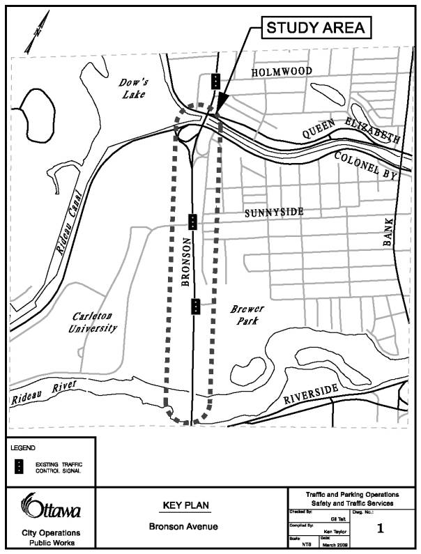
The study portion of Bronson Avenue is approximately 1.2 km in length, and is bounded by bridges over the Rideau Canal to the north, and the Rideau River to the south as illustrated in Document 1. The roadway possesses a six-lane cross-section, directional (on-street) cycling lanes, and is divided.
South of Brewer Way, Bronson Avenue is divided by a raised concrete median. The roadway cross-section is urban, with barrier curb and gutter. Between Brewer Way and Sunnyside Avenue/Campus Avenue, the roadway is divided by a raised concrete median. The cross-section is rural, with gravel shoulders and open drainage, except in the vicinity of the intersections. In the mid-block areas between Sunnyside Avenue/Campus Avenue and Colonel By Drive, the roadway is divided by a grass strip with barrier curb and gutter. The roadway cross-section is urban on the west side, with barrier curb and gutter, and rural on the east side, with gravel shoulders and open drainage.
The posted speed limit on Bronson Avenue south of the study portion is 80 km/h, dropping to 70 km/h as the roadway passes over the Rideau River. The posted speed limit drops to again 60 km/h approaching Sunnyside Avenue/Campus Avenue, and finally to 50 km/h approaching the Rideau Canal, and remains at 50 km/h north of the study area.
As part of the In-Service Safety Review, both a field investigation and office review were undertaken, from which the following problem statements were developed:
· Vehicle operating speeds are excessive for the mixed-use nature of the roadway, despite the presence of posted speed limits and enforcement;
· Rear-end collisions are over represented at the two signalized study intersections;
· Pedestrians and cyclists are displaying unsafe behaviour:
Ø Violation
rates among pedestrians and cyclists crossing Bronson Avenue at Brewer Way were
excessive; .
Ø Mid-block crossing of Bronson Avenue by pedestrians and cyclists was observed;
· Differences in configuration and traffic control strategies between the northbound and southbound ramps at Colonel By Drive increase the potential for road user error and conflicts.
The report proposes various
strategies to reduce the number and/or severity of collisions along Bronson
Avenue. In general, each main strategy
encompassed countermeasures that tackle areas of safety concerns identified in
the study area, from either a Vulnerable Road User or a
Bronson Avenue driver perspective.
Staff concluded the analysis of these safety strategies by preparing an implementation plan, which includes:
§ Upgrading/adding signs;
§ Increasing pavement friction along the corridor;
§ Reviewing lane designations for northbound traffic on Bronson at the approach to the Colonel By Drive ramps;
§ Relocating the existing northbound bus stop location, north of Brewer Way, from a far-side bus stop to a near-side bus stop;
§ Enhancing Pedestrian Environment by providing an asphalt pathway along west side of Bronson Avenue between Colonel By Drive and Brewer Way; and
§ Continuing the City’s Enforcement/Education Campaign (vehicular speeds and pedestrian crossing activities) through the Integrated Road Safety Program.
Strategies
The majority of these safety strategies have been, or are in the process of being, implemented.
New directional signage to Carleton University from Bronson Avenue will be installed and existing parking regulation signage (no-stopping) will be upgraded to emphasize that vehicles should not be stopping on Bronson Avenue to drop off passengers.
In June 2006, high friction asphalt was installed along the study corridor. A preliminary two-year review of the before and after collision history at the intersections revealed that rear-end collisions with road conditions other than dry have been reduced by 39%.
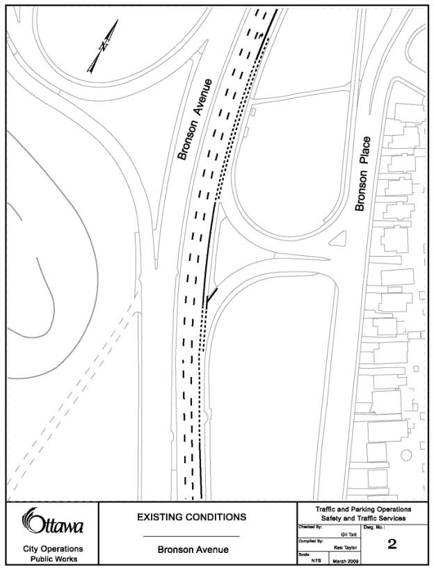
The designation of the northbound curb lane as a right turn lane to Colonel By Drive was, and continues to be, temporarily implemented during Phase 2 of the Bronson Avenue Canal Bridge Rehabilitation Project. This modification was implemented to make the ramps and the associated signs to/from Colonel By Drive on the east side of Bronson Avenue consistent with the ramps on the west side of Bronson Avenue. An internal traffic operational review was conducted with the following observations:
Before (Existing conditions
as shown in Document 2)
· Approximately 65% of vehicles in the curb lane exited to Colonel By Drive, of which many vehicles failed to signal the right-turn movement;
· Vehicles entering Bronson Avenue to head north from Colonel By Drive were, at times, unsure if they could proceed onto Bronson Avenue due to the absence of turn signals of vehicles exiting to Colonel By Drive; and,
· Vehicles were observed to use the curb lane as a “queue jump” to continue north on Bronson Avenue when the turn prohibitions at Findlay Avenue were in effect.
After
No safety concerns were noted during this evaluation period. In fact, it was observed that there was less weaving of northbound vehicles, the elimination of “queue jump” noted above, and fewer vehicles in the curb lane between Colonel By Drive and Findlay Avenue, providing a pedestrian friendly environment on the sidewalk across the Rideau Canal Bridge.
Based on the foregoing, and the fact that the impact to
the operation of the roadway for vehicles is minimal, staff recommends that the
northbound curb lane on Bronson Avenue,
on the approach to the Colonel By Drive off-ramp, be permanently designated as
right turn only and that the roadway modification, as shown in Document 3, be
constructed to ensure that motorists in this curb lane turn right.
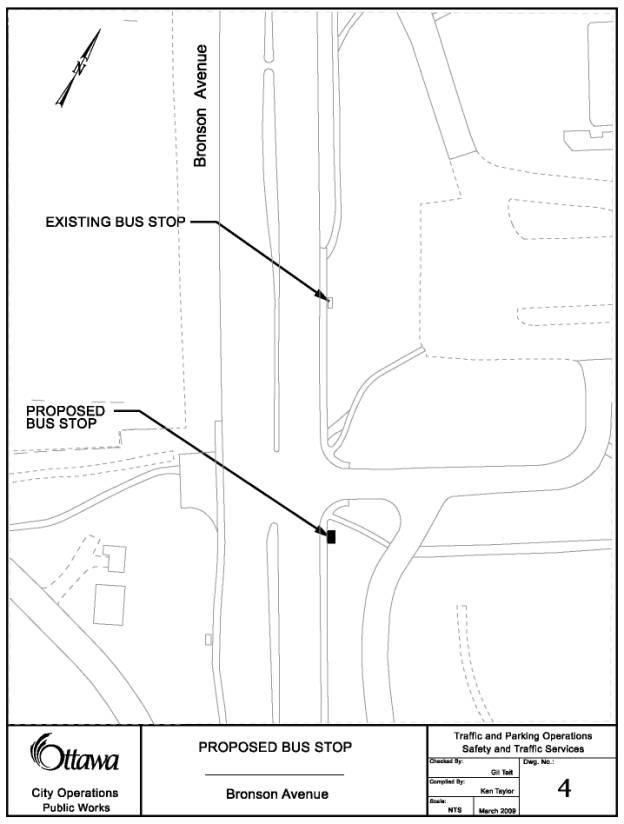
The relocation of the bus stop at Brewer Way from far side to near side, as shown in Document 4, was proposed to minimize the potential of pedestrians to cross mid-block between Sunnyside Avenue and Brewer Way. At the current location of the bus stop on Bronson Avenue, Transit users were observed exiting the bus and crossing Bronson Avenue mid-block, at the bus stop, rather than walking to Brewer Way to cross at the signalized intersection. By moving the bus stop to the near side of Brewer Way, transit users exiting the bus would find themselves at the traffic signal. Staff are currently in discussions with OC Transpo with regards to implementing this measure.
The report mentioned that a number of pedestrians were observed crossing the six lane section of Bronson Avenue between Sunnyside Drive and Brewer Way due to the lack of a pedestrian facility on the west side of Bronson Avenue. There is a high risk of serious injury to pedestrians associated with this type of crossing activity. As a result, the construction of an asphalt pathway, as shown in Document 5, on the west side of Bronson Avenue between Colonel By Drive and Brewer Way is proposed to provide direct connection to the two signalized intersections and to minimize the need for mid-block crossings.
Staff also proposes scheduling the education and enforcement recommendations as part of the 2009 Integrated Road Safety Program and the Selective Traffic Enforcement Program.
Although it was not mentioned in the ISSR report, Pedestrian Countdown Signals were installed in the Fall of 2008 at the signalized intersection of Brewer Way and Bronson Avenue to provide information to pedestrians on the time remaining to cross Bronson Avenue when the flashing “don’t walk” interval is displayed.
City Strategic Directions
The actions recommended in the
report are consistent with the City of Ottawa’s strategic directions for 2007
to 2010, specifically:
- Transportation Priority, Objective 1 Continue to undertake Road Safety Audits along major corridors in order to address traffic safety issues.
Transportation Master Plan
The principles of the Ottawa 20/20 Transportation Master Plan (TMP), Section 9.4 Road Safety are reflected in the safety strategies recommended in this report.
CONSULTATION
Early in the study, consultation was conducted with
stakeholders for their input on existing conditions along Bronson Avenue. Stakeholders included Ward Councillors, who
forwarded study information to members
of their communities, who then provided comments; and
representatives from Carleton University, Ottawa Police Service and the City of
Ottawa.
The Ward Councillors have been briefed on the findings of
the In-Service Safety Review and concur with the implementation plan set out in
this report.
LEGAL/RISK MANAGEMENT IMPLICATIONS
There are no legal/risk management implications to implementing the report recommendations.
FINANCIAL IMPLICATIONS
Low cost strategies, including sign upgrades and the designation of the northbound Bronson Avenue curb lane, between Sunnyside Avenue and the Colonel By Drive off ramp, as a right turn lane only, are an estimated cost of $60,000 to be charged to capital account, 903781, 2006 Safety Improvement Program. To minimize costs we expect to coordinate the construction with the on-going Bronson Avenue Canal Bridge Rehabilitation Project.
Currently, there is no funding to
construct an asphalt pathway along the west side of Bronson Avenue between Colonel By Drive and Brewer Way.
Staff will undertake a preliminary design in 2009 and request funding for
the construction of this safety improvement in the 2010 Capital Budget.
SUPPORTING DOCUMENTATION
Document 1 – Study Area - Bronson Avenue
Document 2
- Existing Conditions - Northbound
Bronson Avenue Curb Lane
Document 3 - Proposed
Lane Designation - Northbound Bronson Avenue Curb Lane
Document 4
- Proposed Bus Stop Relocation
Document 5 - Proposed Pathway
DISPOSITION
The following work will be included in the work plan for the next two years:
§ Complete upgrade and addition of signs identified in the report by the end of 2009;
§ Permanently designate the northbound curb lane, between Sunnyside Avenue and the Colonel By Drive ramp, as a right turn only lane and undertake the construction of the roadway modification in 2009;
§ Undertake a preliminary design for an asphalt pathway along the west side of Bronson Avenue, between Colonel By Drive and Brewer Way, by 2009;
§ Construction of an asphalt pathway along the west side of Bronson Avenue, between Colonel By Drive and Brewer Way, by 2010; and,
§ Conduct a new five-year collision analysis to assess the results of the implementation plan by 2013.
DOCUMENT 1 – STUDY AREA
DOCUMENT 2 – EXISTING CONDITIONS
DOCUMENT 3 – PROPOSED LANE DESIGNATION
DOCUMENT 4 – PROPOSED BUS STOP RELOCATION
DOCUMENT 5 – PROPOSED PATHWAY