|
6. COMPREHENSIVE ZONING BY-LAW
2008-250 – ANOMALies – 20 FRank nighbor road and 613 hazeldean road
ANOMALIES DANS LE RÈGLEMENT DE ZONAGE 2008-250 AU 20,
CHEMIN FRANK NIGHBOR et AU 613, chemin Hazeldean
|
Committee recommendations
(This
matter is subject to Bill 51)
That
Council:
1. Repeal By-laws 2008-458 and 2008-459;
and
2. Approve
the amendments recommended in Document 1, and as shown on Documents 3 and 5
with respect to 20 Frank Nighbor Road and 613 Hazeldean Road.
3. Authorize
the City Clerk and Solicitor to implement Recommendations 1 and 2 either
through by-law enacted by Council or through Orders of the Ontario Municipal
Board.
RecommandationS DU Comité
(Cette demande
est assujettie au Règlement 51)
Que le Conseil :
1.
abroge les règlements municipaux 2008-458
et 2008-459; et
2.
approuve les modifications recommandées
dans le document 1, et illustrées dans les documents 3 et 5 concernant le no
20, chemin Frank Nighbor et le no 613, chemin Hazeldean.
3. autorise le greffier
municipal et chef du contentieux à mettre en oeuvre les recommandations 1 et 2
en vertu de règlements municipaux adoptés par le Conseil ou d’ordonnances de la
Commission des affaires municipales.
Documentation
1.
Deputy
City Manager’s report, Infrastructure Services and Community Sustainability
dated 14 March 2009 (ACS2009-ICS-PLA-0063).
2. Extract of Draft Minute, 14 April 2009.
Report to/Rapport au :
Planning and Environment
Committee
Comité de l'urbanisme et de l'environnement
and Council / et au Conseil
March 14, 2009 / le 14 mars 2009
Submitted
by/Soumis par : Nancy Schepers, Deputy City Manager
Directrice municipale adjointe,
Infrastructure
Services and Community Sustainability
Services d'infrastructure et Viabilité des collectivités
Richard
Kilstrom, Manager/Gestionnaire, Community Planning and Design/Aménagement et
conception communautaire, Planning and Growth Management/
Urbanisme et
Gestion de la croissance
(613) 580-2424
x22653, Richard.Kilstrom@ottawa.ca
|
|
Ref N°: ACS2009-ICS-PLA-0063
|
SUBJECT:
|
COMPREHENSIVE
ZONING BY-LAW 2008-250 – ANOMALies – 20 FRank nighbor road and 613
hazeldean road
|
|
|
|
OBJET :
|
ANOMALIES
DANS LE RÈGLEMENT DE ZONAGE 2008-250 AU 20, CHEMIN FRANK NIGHBOR et AU 613,
chemin Hazeldean
|
REPORT RECOMMENDATIONS
2. Approve the amendments recommended in Document 1, and as
shown on Documents 3 and 5 with respect to 20 Frank Nighbor Road and 613
Hazeldean Road.
3. Authorize
the City Clerk and Solicitor to implement Recommendations 1 and 2 either
through by-law enacted by Council or through Orders of the Ontario Municipal
Board.
RECOMMANDATIONS DU RAPPORT
Que le Comité de l’urbanisme et de l’environnement recommande au
Conseil :
1.
d’abroger les règlements municipaux
2008-458 et 2008-459; et
2. d’approuver les
modifications recommandées dans le document 1, et illustrées dans les documents
3 et 5 concernant le no 20, chemin Frank Nighbor et le no
613, chemin Hazeldean.
3. d’autoriser le greffier municipal et
chef du contentieux à mettre en oeuvre les recommandations 1 et 2 en vertu de
règlements municipaux adoptés par le Conseil ou d’ordonnances de la Commission
des affaires municipales.
BACKGROUND
On June
25, 2008 City Council adopted the new Comprehensive Zoning By-law 2008-250
which affects all properties within Ottawa. By-law 2008-250 replaces the 36
Zoning By-laws of the former municipalities that were amalgamated in 2001. Since the adoption of the Zoning By-law,
staff have been identifying anomalies that require correction, and reports to
correct the anomalies are being forwarded to Committee and Council on a regular
basis.
On November 25,
2008 when Planning and Environment Committee was considering a report
recommending corrections to By-law 2008-250 to resolve a number of anomalies,
including anomalies affecting 20 Frank Nighbor and 613 Hazeldean, staff was
given direction to review the following matter as part of a next anomaly
report:
“that 613 Hazeldean Road and 20
Frank Nighbor Road be included as area specific zones in Section 58 of the
Comprehensive Zoning By-law 2008-250 and that staff keep Committee informed
regarding MTO’s concerns about the floodplain”.
Staff was also
directed to notify interested parties of that public hearing when this report
was to be considered.
The amendments
to the two properties were reflected in By-laws 2008-458 and 2008-459. These
by-laws were subsequently appealed and an Ontario Municipal Board hearing has
been set for end of April 2009.
DISCUSSION
In order to
respond to the motion passed by Planning and Environment Committee, it is first
necessary to explain the overall approach of the Comprehensive Zoning By-law
with respect to the regulation of development within the floodplain. The
“principle of development” is established through the Planning Act
approval processes and Conservation Authorities implement regulations, under
Section 28 of the Conservation Authorities Act, which address the
technical aspects (e.g. floodproofing) of development in the floodplain.
The Official
Plan also directs that the City’s Zoning By-law to regulate permitted uses and
the location and size of buildings in the flood plain. Most municipalities in
Ontario do incorporate the flood plain mapping into their Zoning By-laws in
order to better co-ordinate the provision of flood plain information to the
public, development review and building permit issuance. It should be noted
however, that zoning by-laws cannot regulate such activities as filling and
grading of lands, and any such activities being considered within the flood
plain are under the authority of the Conservation Authorities. The regulations
contained in Section 58 of By‑law 2008-250 were designed in
consultation with the three Conservation Authorities in order to harmonize the
approach used to implement the Official Plan’s Flood Plains policy 4.8.1 on a
city-wide basis.
The former
municipalities used different approaches to identify flood plain areas and
associated regulations. Many former municipalities applied a “HAZ”, hazard,
“O2” open space, “EP” environmental protection or “FP”, floodplain zone
designations to the affected lands.
Former Ottawa, Gloucester and Nepean applied an overlay approach (i.e. a
hatched marking) over the lands with a base zone designation; typically with
the overlay applying more restrictive regulation. Former Kanata and Goulbourn
generally zoned the flood plain as open space but were also the only former
municipalities that used a suffix “f” to any zone designation to indicate
development was allowed in the flood fringe, but with flood proofing provisions
and subject to Conservation Authority approval. Vanier didn’t regulate flood
plains through their Zoning By‑law.
The
new Zoning By-law adopted the overlay approach because the flood plain data
from the Conservation Authorities could be easily imported into the new
electronic zoning map, meaning there was no need to create and map separate
zone designations. There are two types
of flood plain overlays in the Comprehensive Zoning By-law:
- “Flood Plain” Overlay - this is
shown on the zoning maps with diagonal lines, and represents the 100 year
flood plain. Development is not permitted within the lands affected by
this overlay, regardless of the underlying zone designation, other than
minor additions and accessory structures for existing buildings, only as
outlined in Section 58(1), (2) and (3) of the Zoning By-law.
- “Flood Plain – Area Specific
Provisions” Overlay - shown with broken diagonal lines, which represents
part of the flood plain where development is permitted in accordance with
the underlying zone designation, but subject to the Conservation Authority
approval to ensure flood-proofing measures are applied, as stated in
Section 58(4) of the Zoning By-law.
This particular overlay is limited to the existing developed areas
including Constance Bay, Brewer Park, Kingsview Park and Windsor Park –
areas that correspond with the area-specific flood plain areas identified
in the draft of the revision to the Official Plan currently under
consideration.
There were also
four instances in the former Kanata and Goulbourn Zoning By-laws, where
development was permitted in the flood plain on a site-specific basis, as
identified by an “f” suffix on the zoning map. The “f” suffix meant that the
lands or part of the lands were within the flood fringe and standard
flood-proofing construction measures applied with conservation authority
approval. Instead of continuing with an “f” suffix, the Comprehensive Zoning
By-law reflected the “f” provisions in
an exception zone (as shown by “[xxx]” on the zoning maps).
In response to
Committee’s direction that staff review the inclusion of 20 Frank Nighbor and
613 Hazeldean Roads as area-specific zones, if the intent is to have the
Flood Plain – Area Specific Provisions Overlay applied to these two properties;
staff recommend against this principally because the intent of this particular
overlay is to implement the “Two Zone Flood Plain” Policy Area designation in
the City’s Official Plan. This overlay applies only to those areas identified
in the Official Plan as a “two zone flood plain”, and at present only four
areas are proposed in this designation.
Lands along the Carp River in the Kanata West development area are not
included in this particular Official Plan policy at this time.
However
to try to address Committee’s direction, it is proposed to repeal By-laws
2008-458 and 459, which are under appeal, and which modified the wording in the
exception to the zone dealing with development in the flood fringe. As a
replacement, it is recommended that the zoning for these properties more
closely resemble the Ontario Municipal Board approved zoning under the former
Kanata and Goulbourn Zoning By-laws, that is by introducing an “f” suffix,
adding the identical former flood fringe provisions in the exception and
associated definitions into the general provisions of By‑law 2008-250
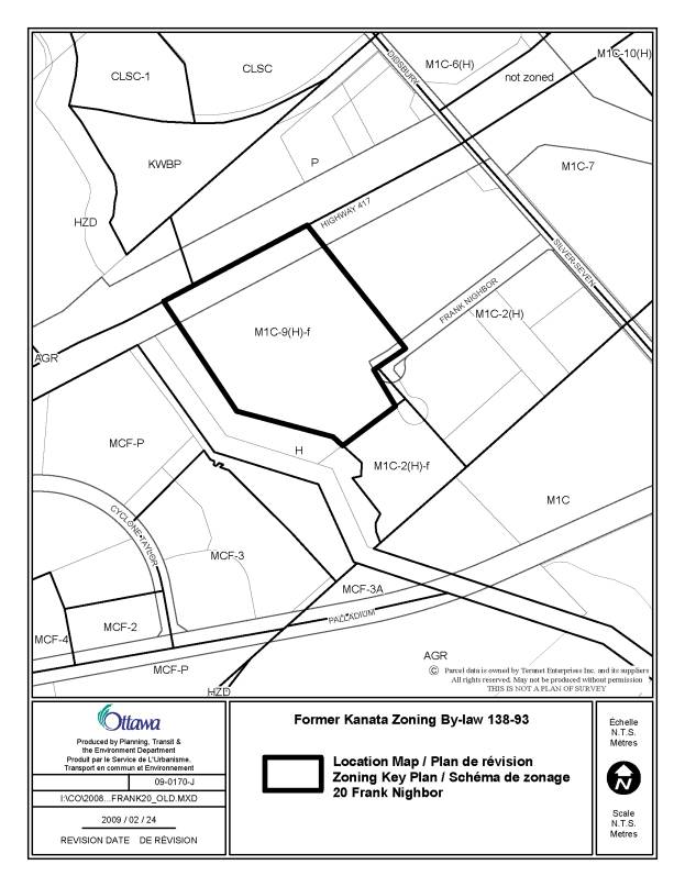
and applying the “f” suffix to these two properties. The former zoning
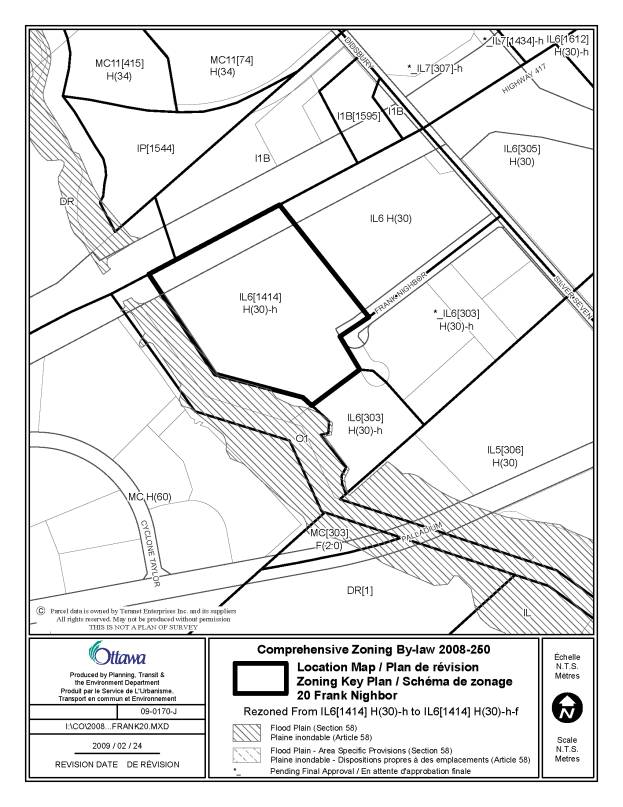
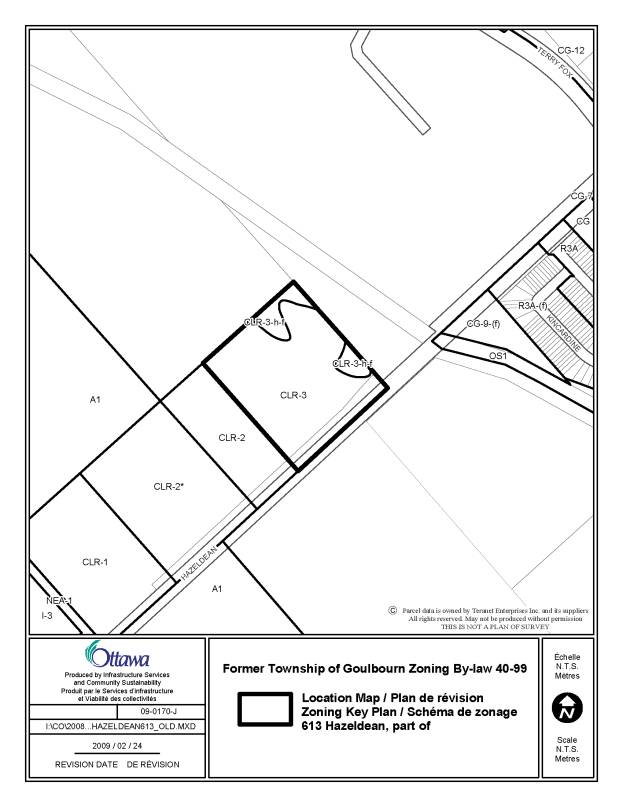
designations for these two properties are illustrated in Documents 2 and 4 and
the proposed change on the zoning maps of By-law 2008-250 is shown on Documents
3 and 5.
With
respect to Committee’s direction that staff keep them apprised of the MTO’s
concerns about the flood plain, it is noted that MTO did send the City a letter
dated November 12, 2008. A response was provided to the MTO explaining that the
Comprehensive Zoning By-law was not removing the flood fringe provisions of the
former by-laws. The proposed repeal of the more recent by-laws affecting these
two properties, and replacement with a zoning approach that looks more like the
previous zoning should alleviate concerns expressed about the zoning of these
lands.
CONSULTATION
Notice of the
public meeting to deal with these anomalies and corrections was provided in The
Citizen and Le Droit, with a listing of the addresses and provisions subject to
correction. As well, interested parties have been notified by individual mail,
including MTO.
LEGAL/RISK
MANAGEMENT IMPLICATIONS
These
recommendations, if carried, will allow the resolution of certain appeals
presently before the Ontario Municipal Board.
FINANCIAL
IMPLICATIONS
N/A
SUPPORTING
DOCUMENTATION
Document 1 Details of
Recommendation
Document 2 Location
Map - 20 Frank Nighbor Road, Former Kanata Zoning By-law Number 138-93
Document 3 Location Map -
20 Frank Nighbor Road, Comprehensive Zoning By-law 2008-250
Document 4 Location
Map - 613 Hazeldean Road, Former Goulbourn Zoning By-law Number 40-99
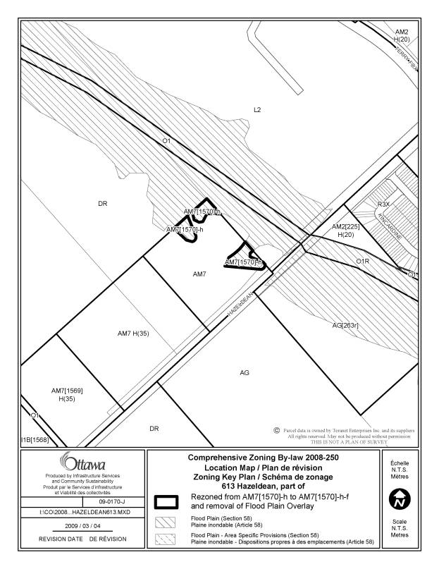
Document 5 Location Map -
613 Hazeldean Road, Comprehensive Zoning By-law Number 2008-250
DISPOSITION
Infrastructure
Services and Community Sustainability Department to prepare the implementing
by-law and forward it to Legal Services who will then forward the by-law to
City Council.
(v) Amend Section 239, exception [1570], Columns II and V by deleting the zone code “AM7[1570]-h” wherever it occurs and
replacing it with “AM7[1570]-h-f”, and Column V is amended by deleting the zone
code “AM7” where it occurs and replacing it with “AM7[1570]-h-f”.
LOCATION MAP - 20 FRANK NIGHBOR ROAD, COMPREHENSIVE
ZONING BY-LAW 2008-250 DOCUMENT
3
LOCATION MAP - 613 HAZELDEAN ROAD, FORMER GOULBOURN
ZONING BY-LAW 40-99 DOCUMENT
4
COMPREHENSIVE
ZONING BY-LAW 2008-250: APPEALS TO THE
ONTARIO MUNICIPAL
BOARD (THIRD REPORT)
RÈGLEMENT GÉNÉRAL DE ZONAGE 2008-250 : APPELS À LA COMMISSION DES
AFFAIRES MUNICIPALES DE L’ONTARIO (TROISIÈME RAPPORT)
ACS2009-ICS-PLA-0062 City Wide/à l'échelle de la Ville
(This
matter is subject to Bill 51)
Françoise
Jessop, Program Manager of Zoning Studies and Area Planning, provided a
PowerPoint presentation, which is held on file with the City Clerk.
Tim Marc,
Senior Legal Counsel, advised that there was no appeal on these two properties
with respect to the Comprehensive Zoning By-law. With respect to 20 Frank Nighbor Road, there was an appeal on the
amendment to the former City of Kanata by-law, which was withdrawn by the
appellant. With regard to 613 Hazeldean
Road, the Ontario Municipal Board (OMB) rendered a decision in the City’s
favour. He indicated that by-law
2008-250 did not accurately reflect these properties. Planning staff brought forward a report in November 2008 and
there was request that the language of the former Kanata by-law be
utilized. Staff are now attempting to
re-create the situation that existed after the two appeals had been dealt with
in the Spring of 2008. Almost the same
language would be used in the hope that this matter could be resolved without
the necessity for a hearing.
In
response to questions from Councillor Holmes, Ms. Jessop indicated that
Documents 3 and 5 reflect the zoning found in the Comprehensive Zoning
by-law. The flood plain overlay is
normally based on the 100-year floodplain, but in this case, because of the
flood fringe area on Document 3 for 20 Frank Nighbor Road, the map shows were
development would not be permitted at all.
Mr. Marc
confirmed that the maps are based on conservation authority (CA) mapping dating
back to 1983. He countered the alleged
inconsistency between the City’s position before the OMB, where the City stood
by the 1983 floodplain mapping and the position of the City before the
Court. In the litigation arising from
the Glen Cairn flooding that occurred in 1996 and 2002, there is a position
that the incorrect storm was used for 1996.
Floodplain mapping is dictated by the province through guidelines that
say that the 100-year storm must be used, which has been done by the
Mississippi Valley Conservation Authority (MVCA). With respect to the design of culverts, he advised it involves
engineering judgement with respect to the sort of storm to use. The consultant in the 1996 flood report
chose one storm and the consultant in 2002 chose a different storm. Mr. Marc clarified that it is the basis of
that difference in choice of storms with respect to culvert design that was the
allegation in the litigation against the 1996 consultant that the City is
pursuing. The decision from the Court
in January 2009 deals with this specific issue. Mr. Marc stated that he has read the 2002 report and found
therein no criticism of the MVCA. In
his view, the issues are apples and oranges, involving different storms for
different purposes. He posited that
there is no inconsistency between the City’s positions before the OMB and the
Court.
Mr. Marc
undertook to determine if a report came forward to Corporate Services and
Economic Development Committee on the Superior Court case. With regard to the case, he indicated that a
motion for summary judgement was dismissed; therefore, the matter is on going
and being handled by outside counsel.
The City Clerk and Solicitor will provide information on the requested
damages in the case.
Councillor
Holmes asked if water run-off from the Fernbank lands was taken into account in
the floodplain mapping shown in the proposed by-law. Mr. Marc repeated answers provided at the briefing on the results
of the Carp River Third Party Review.
At the time of the 1983 floodplain mapping, the area would not have been
developed. The answer provided by
Donald Moss of Greenland Consulting Engineers was that Fernbank will have to
take the situation as a given (i.e. the proponents will have to address the
floodplain as it is and not add water to increase the floodplain).
Ted Cooper spoke
from a PowerPoint presentation, which is held on file with his detailed
submission that included an email dated 13 April 13 2009, letter to the OMB
dated 27 March 27 2009, and copy of Superior Court of Justice Decision (Court
Files 02-CV021270 and 02-CV-21270A).
Mr. Cooper raised the following matters, which are developed in detail in
his submissions:
·
There exists an error in the extent of the
floodplain shown in the proposed by-law for 20 Frank Nighbor Road.
·
The flood lines used in the proposed by-law are
out-of-date, as they are based on 1983 floodplain mapping from the MVCA. Flood flows should be based on a more
appropriate design storm – the 24-hour Chicago Storm.
·
The 1983 flood flows were calculated using a 12-hour
SCS Design Storm. These flows are more
appropriate for rural watersheds but land use has changed in the area and is
now mostly urban.
·
The Third Party Review released on 9 April 2009 is
inconsistent with the CCL Report used by the City in its defence of the Class
Action Lawsuit after flooding had occurred in Glen Cairn. It does not provide any resolution to
previously raised concerns about the proposed zoning by-law. The design storm used by Greenland
Consulting Engineers in floodplain analysis was the 12-hour SCS Design Storm.
The City of Ottawa’s position in Superior Court is that it is negligent to
calculate the 100-year flood flows using a 12-hour SCSC Design Storm because of
urbanization.
·
The use of site-specific two-zone policy does not
meet the intent of the Natural Hazard policies of the Provincial Policy
Statement (PPS).
·
The proposed by-law sets no conditions that are
recommended in the Third Party Review.
Notably, each development should provide additional at source volume
prorated on contributing area based on 100 to 120 cubic metres per
hectare. Limitations on the extent of
interim development allowed should be set out in the zoning by-law.
·
The proposed by-law proposes zoning of flood fringe
(a two-zone policy); while, the Third Party Review states that a modified one
zone policy is being used.
·
As the appellant to two OMB appeals, he has not
received confirmation from the Board or from property owners that they agree
that the zoning by-laws current under appeal should be repealed; furthermore,
it is uncertain whether the proposed process is consistent with Planning Act requirements.
·
Mr. Cooper has a filed a request with the OMB Chair
to allow a Motion for Rescission of the 25 April 2008 Order to be heard due to
contradictory testimony by the City at the February 2008 OMB Hearing and May
2008 Ontario Superior Court Hearing.
He made
the following six recommendations:
1. Not
approve the zoning by-law as proposed, as it will be appealed to the OMB.
2. Seek
adjournment of the April 23-23 OMB Hearing regarding 613 Hazeldean Road.
3. Consider
the application of Section 3.1.3 (b) of the PPS.
4. Reconcile
the proposed zoning by-law amendment with other Carp River processes.
5. Organize a
meeting with the CA, provincial ministries about floodplain policies and
whether a modified one zone policy is consistent with the PPS.
6. Move
forward with the zoning by-law only after issues with the Third Party Review
and Minister’s Order are resolved.
Michael Polowin, on behalf of the TDL Group Corp,
the operator of Tim Horton restaurants, agreed with some of the submissions
brought forward by Mr. Cooper. He
stated the following:
§
TDL
has appealed, among other provisions, Section 58 of the new Comprehensive
Zoning By-law, which prohibits development in lands mapped as being in the
floodplain.
§
Section
58 should be repealed, as it is not the place of the City to be dealing with
these matters. This provision did not
exist in most of the former municipalities, including the former City of Ottawa
and the former City of Vanier.
§
The
provision is completely unnecessary, as it duplicates the authority of the
relevant CA granted by the Province. Each CA is empowered to map the relevant
floodplains and to pass regulations that prohibit, regulate, or require the
permission of the authority for development.
This is not reflected in the staff report.
§
The
provision also represents hardship on individual property owners. If a property owner proposes to develop in a
floodplain, he/she must meet with the relevant CA, and work out whether or not
that is in fact possible. If an
accommodation can be reached with the CA, Section 58 obligates the property
owner to bring forth an application for rezoning. Under the City’s fee schedule, a major rezoning application fee
represents $12,610. In addition, the
applicant, in the event of an appeal to the OMB, must cover the City’s legal
fees. In addition, costs would be
accrued by the proponent for the assistance of planners, engineers, and
lawyers.
§
He
contended that staff acknowledged the potential duplication and hardship, but
were proceeding to ensure that Building Code branch staff would have greater
notice and not allow things to fall between the cracks.
§
The proposed
change that allows a distinction to be made between the floodway, where fast
moving water in the 1:100-year flood will flow, and in the flood fringe, where
such water will pool at low levels, should be extended to the entire city, if
not deleted entirely.
§
Section
58 will lead to repeated OMB appeals and should be repealed.
In response to questions from the
Chair regarding changes to floodplain mapping, Mr. Marc confirmed that if
a proponent receives a cut or fill permit from the CA to proceed with
development in the floodplain, a zoning amendment would also be required.
Mr. Polowin also added that it is
also within the realm of possibility that a property owner could bring
engineering information to the CA that proves that the 1983 mapping is inaccurate
in certain circumstances. If the CA
agrees, a rezoning application would still be required.
Ms. Jessop responded that the City
would proceed with a City-initiated zoning amendment for broad mapping
corrections brought forward by the CA.
The Planning branch intent would be to keep the zoning by-law current
with the most up-to-date mapping available.
Mr. Polowin countered that a
zoning amendment would still be required for cut and fill permits issued by the
CA. He suggested time and money could be
saved if the City simply repealed Section 58, as responsibility for the
floodplain is vested with the CA.
Ms. Jessop clarified that the
former City of Ottawa did have a similar overlay that restricted what could be
developed in the floodplain, as did every single former municipality with the
exception of Vanier. She suggested
staff applied a consistent approach citywide to implement the policies of the
Official Plan (OP). She agreed that the
CA deals with some of the technical aspects, but it is appropriate for someone
who wants to develop in that floodplain to go through a site-specific review.
Mr. Polowin did not agree with
this reasoning that supports repeating the mistake of over regulation in the
first instance. He reiterated that
there is an unfortunate burden that has been placed on property owners and the
best alternative would be to simply repeal Section 58 of the by-law.
Greg Winters, Novatech Engineering
Consultants,
spoke on behalf of 764703 Ontario Inc, owners of 20 Frank Nighbor
Road. He expressed support for some of
the concerns raised by Mr. Polowin and the staff report. He recalled that the provisions originated
through an amendment in 2002 supported by the City and the MVCA, following a
thorough review of the floodplain area adjacent to the site. A more recent study has been completed, and
the conclusions show that there is no change to the flood elevations adjacent
to the site immediately adjacent to the 417.
The proposed by-law merely carries forward the exact same provisions that
were in the former City of Kanata by-law and better reflects the provisions
that should be in place.
Mr. Winters agreed with
Mr. Polowin that the burden under provincial law rests with the MVCA, the
recognized approval authority for floodplains.
He pointed out that City staff have indicated that they could not use
the floodplain overlay designation in the zoning mapping because it prohibits
development on the sight. He said staff
correctly showed the overlay to be limited to the hazard portion of the
floodplain. The hatching follows the
exact line of the hazard limit that was in the original Kanata zoning
by-law. To demonstrate the rest of the
floodplain on the remaining balance of the site, staff used the “F” suffix,
which is a method that has been approved by the Province of Ontario for use by
municipalities in zoning by-laws. In
doing so, staff are respecting the flood elevation from the MVCA shown on the
1983 mapping of the site.
In response to a question from the
Chair, Mr. Winters confirmed the Cantor family, who hired the Regional Group of
Companies to represent them with the support of Novatech Engineering
Consultants, owns the lands.
Miguel Tremblay, FoTenn, was present on behalf of Riotrin
Properties (Hazeldean) Inc. c/o Trinity Development Inc. He submitted a letter dated 13 April 2009,
which is held on file with the City Clerk.
He viewed the amendment as a housekeeping
matter, bringing some consistency with the language of the Comprehensive Zoning
By-law and recently OMB-approved zoning. He confirmed support for staff’s
efforts and RioTrin will be moving forward with the April 2009 OMB hearing to
resolve outstanding issues.
Councillor Holmes brought forward a motion for government
stakeholders to meet to resolve on-going issues with the 1983 mapping. Chair Hume suggested it could be dealt with
as a staff direction.
John Moser, General Manager of Planning and Growth Management,
accepted the motion as direction.
That
Planning and Environment Committee recommend that Council:
1. Repeal By-laws 2008-458 and 2008-459
2. Approve the amendments recommended in
Document 1, and as shown on Documents 3 and 5 with respect to 20 Frank Nighbor
Road and 613 Hazeldean Road.
3. Authorize the City Clerk and Solicitor
to implement Recommendations 1 and 2 either through by-law enacted by Council
or through Orders of the Ontario Municipal Board.
CARRIED
DIRECTIONS TO STAFF:
1. The City of Ottawa,
Conservation Authorities, Ministries of Natural Resources and Municipal Affairs
and Housing will meet to discuss Ottawa flood plain and flood fringe mapping,
zoning and potential development.
2. The City Clerk and
Solicitor will provide the report on the Superior Court case, as well as the
cost of the litigation.