|
2. Sale of
property – 113 Mcarthur Avenue vente de propriété – 113 avenue mcarthur |
COMMITTEE RECOMMENDATIONS
That
Council:
1. Declare
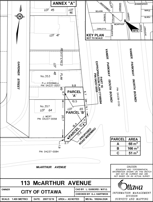
the properties shown as Parcels “A” and “B” on Annex “A” attached, containing
approximately 234 m2 (2,518.83 square feet), municipally known as
113 McArthur Avenue and described as part of lot 65, Registered Plan 49, being
part of part 18 Expropriation Plan CT166094, former City of Vanier now in the
City of Ottawa, as surplus to the City’s needs; and
2.
Approve the sale of Parcel “A” on Annex “A” attached,
containing an area of 68 m2 (731.96 square feet) municipally known
as part of 113 McArthur Avenue, described as part of lot 65, Registered Plan
49, being part of part 18, Expropriation Plan CT166094, former City of Vanier
now in the City of Ottawa, subject to any easements that may be required to
Pamela O’Donnell for the amount of $7,320 plus survey costs and GST, pursuant
to an Agreement of Purchase and Sale that has been received.
RECOMMENDATIONS DU COMITÉ
Que le Conseil :
1.
déclare excédentaires aux besoins de
la Ville les propriétés indiquées comme les parcelles « A » et
« B » dans l’Annexe « A » ci-jointe, d’une superficie
d’environ 234 m2 (2,518.83 pieds carrés) et dont la désignation
civique est le 113, avenue McArthur, décrites comme une partie du lot 65, Plan
49, partie de la partie 18, plan d’expropriation CT166094, ancienne ville de Vanier; maintenant dans la
ville D’Ottawa; et
2.
approuve la vente de la propriété
indiquée comme la parcelle « A » dans l’Annexe « A »
ci-jointe, d’une superficie d’environ 68 m2 (731,96 pieds carrés) et
dont la désignation civique est le 113, avenue McArthur, décrite comme une
partie du lot 65, Plan 49, sous réserve de toute servitude qui pourrait être
requise, à Pamela O’Donnell pour la somme de 7,320 $, TPS en sus, plus les
frais du plan de levé, conformément à la convention d’achat-vente reçue.
DOCUMENTATION
1. City
Manager’s report dated 10 February (ACS2008-CMR-CPO-0009).
Report to/Rapport au:
Corporate Services and
Economic Development Committee
Comité des services organisationnels et du
développement économique
and Council / et au Conseil
10 February 2009/ le 10 février 2009
Submitted by/Soumis par: Kent Kirpatrick, City Manager / directeur municipal
Contact Person/Personne ressource : Gordon MacNair, Manager, Real
Estate Services
Corporate Project Office /
gestionnaire, Services immobiliers,
Bureau des projects municipaux
(613)
580-2424 x 21217, Gordon.MacNair@ottawa.ca
|
SUBJECT: |
|
|
|
|
|
OBJET : |
REPORT RECOMMENDATIONS
That
the Corporate Services and Economic Development Committee recommend Council:
1. Declare
the properties shown as Parcels “A” and “B” on Annex “A” attached, containing
approximately 234 m2 (2,518.83 square feet), municipally known as
113 McArthur Avenue and described as part of lot 65, Registered Plan 49, being
part of part 18 Expropriation Plan CT166094, former City of Vanier now in the
City of Ottawa, as surplus to the City’s needs; and
2. Approve the sale of Parcel “A” on Annex “A” attached, containing an area of 68 m2 (731.96 square feet) municipally known as part of 113 McArthur Avenue, described as part of lot 65, Registered Plan 49, being part of part 18, Expropriation Plan CT166094, former City of Vanier now in the City of Ottawa, subject to any easements that may be required to Pamela O’Donnell for the amount of $7,320 plus survey costs and GST, pursuant to an Agreement of Purchase and Sale that has been received.
RECOMMANDATIONS DU RAPPORT
Que le Comité des
services organisationnels et du développement économique recommande au
Conseil :
1.
de déclarer excédentaires aux
besoins de la Ville les propriétés indiquées comme les parcelles
« A » et « B » dans l’Annexe « A » ci-jointe,
d’une superficie d’environ 234 m2 (2,518.83 pieds carrés) et dont la
désignation civique est le 113, avenue McArthur, décrites comme une partie du
lot 65, Plan 49, partie de la partie 18, plan d’expropriation CT166094, ancienne ville de Vanier; maintenant dans la
ville D’Ottawa; et
2.
d’approuver la vente de la propriété
indiquée comme la parcelle « A » dans l’Annexe « A »
ci-jointe, d’une superficie d’environ 68 m2 (731,96 pieds carrés) et
dont la désignation civique est le 113, avenue McArthur, décrite comme une
partie du lot 65, Plan 49, sous réserve de toute servitude qui pourrait être
requise, à Pamela O’Donnell pour la somme de 7,320 $, TPS en sus, plus les
frais du plan de levé, conformément à la convention d’achat-vente reçue.
BACKGROUND
As a result of an inquiry from the abutting owner
expressing interest in purchasing the subject property, a circulation was
undertaken to City departments to determine if the property could be potentially
surplus to the City’s requirements. The
subject property is a vacant parcel of land, legally described as part lot 65,
Registered Plan 49 shown as part of part 18, Expropriation Plan CT166094. The property is rectangular in shape and
contains an area of approximately 234 m2 (2,518.83 square feet) and is
located at the northwest corner of the Vanier Parkway and McArthur Avenue.
The
subject property is a residual parcel that was expropriated by the Regional
Municipality of Ottawa-Carleton in 1973 for the construction of the Vanier
Parkway. Although Parcels “A”
and “B” are being declared surplus, only the northerly portion, shown as Parcel
“A” on the Annex “A” attached having an area of 68 m2 (731.96 square feet), is being
sold at this time.
DISCUSSION
A circulation was sent to all City departments and utility agencies in April 2007 to determine if there was any requirement for the property. No City departments or utility agencies expressed any interest. As this was an expropriated property, an attempt was made to contact the original owner but it was confirmed that the original owner of Parcels “A” and “B” is deceased. This property was determined to be a non-viable property pursuant to an internal appraisal and was offered for sale to the two abutting owners at 353 and 357 Gardner Street. The parcel being sold is shown as Parcel “A” on Annex “A” attached and abuts 353 Gardner Street. The owner of the property at 357 Gardner Street had shown an interest in purchasing Parcel “B” but recently decided not to pursue the acquisition at this time.
An asking price of $7,320 was established for Parcel “A” based on the findings of an internal appraisal dated October 2008. The offer received by Pamela O’Donnell in the amount of $7,320 is considered fair and reasonable and is supported by the internal appraisal.
The zoning designation for this property is R5D (H 25) Residential First Density Zone, City of Ottawa, Zoning By-law 2008-250 and permits single detached dwellings, apartments and row dwellings. The purchaser intends to use the property to enlarge the backyard of her single detached dwelling.
CONSULTATION
In accordance with policies approved by City Council on 14 November 2001, the availability of the property was circulated to all client City Departments, including the Affordable Housing Division, Infrastructure Services and Community Sustainability, City Operations, to determine if the property should be retained for a City-mandated program. The Environmental Sustainability Division of the Infrastructure Services and Community Sustainability Department was consulted with respect to the Urban Natural Area Environmental Evaluation Study and Greenspace Master Plan. Their comments are indicated under the Environmental Implications section of this report. Neither the Affordable Housing Division nor any City Department expressed interest in retaining the property.
The following Advisory Committees have been circulated:
Local Architectural Conservation Advisory Committee (LACAC)
Ottawa Forests and Greenspace Advisory Committee (OFGAC)
Environmental Advisory Committee (EAC)
Parks and Recreation Advisory Committee (PRAC)
Roads and Cycling Advisory Committee (RCAC)
Pedestrian and Transit Advisory Committee (PTAC)
Rural Issues Advisory Committee (RIAC)
No concerns were expressed with respect to the sale of the subject property.
The ward Councillor was made aware of the proposed sale and supports staff’s recommendation to sell the property. As this is a non-viable property, no community consultation was undertaken with respect to its disposal and the ward Councillor concurs with this process.
ENVIRONMENTAL IMPLICATIONS
The subject property does not contain significant natural environment lands and has not been identified in the Urban Natural Areas Environmental Evaluation Study (March 2006). No implications to the natural environment have been identified for the proposed sale of this property.
HOUSING FIRST POLICY
The Official Plan policy directs
that the City make land available for affordable housing and give priority for
the sale or lease of surplus City-owned property for this purpose. The Housing First Policy, approved by
Council on 13 July 2005, establishes priority consideration to the Housing
Branch, in the identification of potentially surplus City-owned property, to be
used in achieving the City’s affordable housing program targets. The policy also requires that the Official
Plan target of 25% affordable housing, be met on any City-owned property sold
for residential development. Where
viable, residential properties are disposed of without a condition requiring an
affordable housing component, 25% of the proceeds from the sale are to be
credited to a housing fund, to be used for the development of affordable
housing elsewhere in the City.
The subject is a non-viable residential property and is being sold without a condition requiring an affordable housing component.
LEGAL/RISK MANAGEMENT IMPLICATIONS:
There are no
legal/risk management impediments to implementing any of the Recommendations
arising from this Report.
FINANCIAL IMPLICATIONS
This transaction represents revenue of $7,320 to the Corporation, to be credited to the City’s Sale of Surplus Land Account.
SUPPORTING DOCUMENTATION
Attached, as Annex "A" is a sketch showing the surplus property.
DISPOSITION
Following Council’s approval, Corporate Project Office and Legal Services will finalize the transaction.