|
2. ESCARPMENT AREA DISTRICT
PLAN PLAN DE
DISTRICT DE LA ZONE DE L'ESCARPEMENT |
Committee recommendation
That Council approve Document 2 - Escarpment
Area District Plan, a Community Design Plan to implement the Downtown Ottawa
Urban Design Strategy as Council's direction on the future development of the
area in accordance with the provisions set out in Document 4.
Recommandation du Comité
Que le Conseil
approuve le document 2, intitulé Plan de district de la zone de l’Escarpement,
plan de conception communautaire pour la mise en place de la Stratégie
d’aménagement urbain du centre-ville d’Ottawa, en tant que directive du Conseil
pour l’aménagement futur de cette zone en conformité avec les dispositions
énoncées dans le Document 4.
Documentation
1.
Deputy
City Manager's report, Infrastructure Services and Community Sustainability,
dated 12 November 2008 (ACS2008-ICS-PLA-0081).
2. Extract
of Minutes 45, 25 November 2008.
Report to/Rapport au :
Planning and Environment
Committee
Comité de l'urbanisme et de
l'environnement
and Council / et au Conseil
12 November 2008 / 12 novembre 2008
Submitted by/Soumis par : Nancy
Schepers, Deputy City Manager
Directrice municipale adjointe,
Infrastructure
Services and Community Sustainability
Services
d’infrastructure et Viabilité des collectivités
Contact Person/Personne ressource : Richard
Kilstrom, Manager/Gestionnaire, Community Planning and Design/Aménagement et
conception communautaire, Planning Branch/Direction de l’urbanisme
(613) 580-2424 x 22653 Richard Kilstrom@ottawa.ca
|
SUBJECT: |
|
|
|
|
|
OBJET : |
REPORT
RECOMMENDATION
That Planning
and Environment Committee recommend that Council approve Document 2 - Escarpment Area
District Plan, a Community Design Plan to implement the Downtown Ottawa Urban
Design Strategy as Council's direction on the future development of the area in
accordance with the provisions set out in Document 4.
RECOMMANDATION DU RAPPORT
Que le Comité de l'urbanisme et de l'environnement recommande au Conseil d’approuver le Document 2, intitulé Plan de district
de la zone de l’Escarpement, plan de conception communautaire pour la mise en
place de la Stratégie d’aménagement urbain du centre-ville d’Ottawa, en tant
que directive du Conseil pour l’aménagement futur de cette zone en conformité
avec les dispositions énoncées dans le Document 4.
BACKGROUND
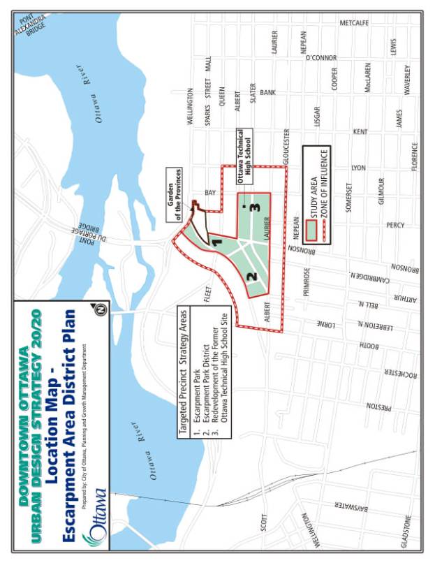
On November 22, 2005 Planning and Environment Committee approved the terms of reference for the Escarpment Area District Plan study, which is a Phase II implementation plan of the Downtown Ottawa Urban Design Strategy (DOUDS) approved by City Council in March 2004. The District Plan addresses three of the targeted precinct strategies of DOUDS, including Escarpment Park, Escarpment Park District and the Redevelopment of the Former Ottawa Technical High School Site.
The goal of the study was to:
- Identify potential development parcels and establish guidelines to ensure a quality built form;
- Prepare design proposals for the public realm, green links and propose new major open spaces, including a community park;
- Prepare design guidelines on a block-by-block basis to guide site-specific development applications and public realm improvement plans;
- Reach a consensus with the affected major property owners and the adjacent community on the future development of the area.
The study area (Document 1 - Location Map) is irregularly shaped and is generally bounded by LeBreton Flats on the west, the Garden of the Provinces on the north and east, Bay Street on the east and Laurier Avenue on the south. Three public agencies own most of the lands within the study area – the City of Ottawa, the National Capital Commission (NCC) and the Ottawa-Carleton District School Board (OCDSB). A zone of influence encompasses the immediate blocks/areas adjoining the study area. Its existing character and planned future development were considered in the development of the District Plan's recommendations.
DISCUSSION
The
recommendation is to approve the Escarpment Area District Plan as Council's policy
for the future development of the area.
This document is intended to be a Community Design Plan to implement the
Downtown Ottawa Urban Design Strategy.
Following approval of this report, as was done following Council
approval of the Downtown Ottawa Urban Design Strategy, staff will prepare an
Official Plan Amendment (OPA) to the Central Area Secondary Plan, primarily its
Upper Town chapter, to update the text so as to incorporate the main policy
directions of the District Plan. A
Zoning By-law Amendment to implement the District Plan recommendations will
follow the finalization of agreements with the OCDSB to create the new
community park.
Planning Strategy
The
planning strategy/vision for the Escarpment Area provides a framework for
change that will see the area become a diverse and attractive downtown
community celebrated for its natural features, the quality and character of its
open spaces, public realm and new buildings.
At its heart, a new central park will act as a neighbourhood focus. New high quality mixed-use buildings and an
enhanced greenspace network will help bridge the gap between the emerging
LeBreton Flats community and the downtown core.
The
District Plan also seeks to establish a new benchmark for high-density built
form in the city that is more pedestrian-friendly, addresses the street better,
and results in a more visually appealing development. Development must break from the traditional slab-style building,
which has characterized this area since the 1970s, to a more slender
"point tower" form to help preserve views and access to sunlight,
substantially reduce shadow impacts, maintain privacy and eliminate blank walls
and inanimate facades. This is a major concern of area residents.
At
the foot of these towers, a strong podium base will be pedestrian-scaled and
articulated, emphasizing street-oriented residential units or local commercial
uses, to help animate the street and reduce the impact of taller
structures. The point tower and podium
combination has been successfully used in many other cities and helps create
liveable environments that can be well integrated with existing neighbourhoods.
Downtown Ottawa Transit Tunnel
Environmental Assessment Study
The original draft 2006 Escarpment Area District Plan was based on the North-South LRT proposal. When City Council in December 2006 decided not to proceed with the initiative, the Plan needed to be revised to accommodate Council's new rapid transit plan, in particular the downtown transit tunnel. The District Plan being presented for approval in Document 2 reflects the objectives for the Downtown Ottawa Transit Tunnel Environmental Assessment (EA) study now underway. Of critical importance is that the EA include the principle of maximizing the development potential of the City-owned lands, located east of Booth Street and north of Albert Street at the base of the escarpment, in the selection of a preferred transit alignment and the location of the downtown tunnel portal.
Escarpment District Area Plan Key
Proposals
A number of key proposals make up the framework plan that, once completed, will help realize the vision, as follows:
Central Park
(known in the community as Uppertown Commons)
This new proposed central park, which is approximately 0.9 hectares in area, is located on the western half of the block bounded by Slater and Bay Streets and Laurier and Bronson Avenues. The proposed park site presently has two owners - the Ottawa-Carleton District School Board, with approximately 0.5 hectares (57%); and, the City, with approximately 0.4 hectares (43%), the latter currently composed primarily of community gardens on a temporary license of occupation at nominal cost to the Nanny Goat Hill Community Garden Association. Although the existing recreational, open space and community garden uses are proposed to continue occupying this central park area, it is not officially a City park at present and the lands could be developed for buildings in the three- to 12-storey height range under the existing zoning. During the public consultation for the Escarpment Area District Plan, strong community support was voiced for retention of the community gardens, thus the District Plan includes the gardens as a part of the park's continuing activities.
Discussions have been held with OCDSB staff regarding dedication of the school lands for the park at no cost to the City in return for increased development rights on the remainder of the Board's lands. Approval of this report will allow this negotiation process to continue with the OCDSB to secure the lands as park space as outlined in Document 4.
The
OCDSB's most recent comments, in June 2007, stated that they share the common
vision with the City for a park.
However, in the OCDSB's view the size of the park could be smaller, with
the boundary shifted westward to line up with Percy Street, as a rationale has
not been provided for its proposed size.
The OCDSB's land area for development and the number of residential
units could potentially thus be increased.
Some
area residents would have preferred a larger park, as detailed in Document 3,
that would have included all of the OCDSB lands on the block bounded by Slater
and Bay Streets and Bronson and Laurier Avenues. However, the proposed park will be the largest new City park
spaces to be created in the downtown.
Its size and location were established in the Downtown Ottawa Urban
Design Strategy, which had extensive public consultation and Council approval
in 2004.
Further, the most easterly 0.4 hectares of the parcel owned by the OCDSB in this block is not presently open space, as it contains one of the Technical High School's gymnasiums and the school parking lot. As noted previously, in order for the OCDSB to agree to dedicate a portion of their lands for the park at no cost to the City, increased development rights will need to be granted on the remainder of their lands.
The proposed park will be the focal point for community activity and will help offset any potential impacts of new development on the adjacent neighbourhood. As intensification continues in the downtown and inner city area, it is crucial that public amenities, in particular park space, correspondingly increase if intensification is to be successful. Key to the park’s success will be its ability to support both a range of existing activities (e.g., community gardens, Tech or Piece Wall, and playing field), and new activities that will complement the existing ones. Once the park space is secured, the City will need to engage in a community design process to determine the specific design, type of facilities and official name for the new park.
Technical High School Site North Parcel
The District Plan
proposes four development options for the Technical High School site north
parcel, bounded by Slater, Albert and Bay Streets. The four options are: entirely residential; residential and
office towers; residential and existing Technical High School auditorium; and,
residential, office and auditorium, all with ground floor commercial along the
street frontage. For the existing
school building, the auditorium, with a gymnasium below, appears to have the
most significant heritage value, and a heritage impact assessment will be
required before site redevelopment can move forward. Maximum building heights of 72 metres are proposed in the
District Plan along Bay Street, with the remainder of the site proposed to have
a maximum tower height up to 56 metres, with connecting podiums of three to six
storeys.
The office option, with or without the auditorium, could potentially accommodate a new central library and City archives should this parcel be considered for further study as a candidate site for that purpose.
Technical High School Site South Parcel
The strategy for the south parcel (between Slater Street and Laurier Avenue) redistributes potential density to the east in order to provide the new park to the west. East of the park, four residential point towers will step up in height towards Bay Street from 56 to 72 metres, with a three- to six-storey podium. This building form will help define the streets and the new park, and will maximize views towards the park and LeBreton Flats. Ground floor retail, including such uses as a grocery store, restaurants and convenience commercial as well as street-oriented residential units, can be accommodated in this location along the street frontage.
North/South
Pedestrian Mews
A mid-block pedestrian mews will define the western edge of the site, running north-south from Slater Street to Laurier Avenue. The mews will provide a transition between the park and the new residential development, as well as an important front-door address for that development. It will facilitate pedestrian movement though the district and provide a link from Percy Street to the transit stops on Albert and Slater Streets. Once completed, the mews would be dedicated to the City as a public right-of-way.
Bronson Park
Improvements
The NCC-owned Bronson Park, at the western end of Queen and Sparks Streets, is located at the top of the escarpment overlooking LeBreton Flats. The District Plan proposes to enhance this underused park space with a combination of hard and soft landscape elements. Pedestrian movement along Sparks Street could be extended to eventually link through Bronson Park to LeBreton Flats via a vertical connection down to the base of the escarpment.
Escarpment
Park
The Escarpment Park area is an important greenspace link located mid-way between Upper Town, LeBreton Flats and the Ottawa River. Through extensive landscaping and use of stone retaining walls, the visual presence of the limestone escarpment will be reinforced and will provide the main greenspace entry point to LeBreton Flats. Both Bronson Park and Escarpment Park would be joint NCC/City projects.
Albert,
Bronson and Slater Block
The remainder of the block west of the Technical High School north parcel, bounded by Slater Street, Bronson Avenue and Albert Street, provides an opportunity for the introduction of some new high-rise and low-rise developments, as shown in the Escarpment Area District Plan, while retaining existing heritage buildings. For redevelopment in this block to occur, some of the affected properties would need to be consolidated and an arrangement entered into between the owners of the land and the adjacent properties to the north where existing heritage buildings would be retained.
South
LeBreton
Only a conceptual design has been developed in the Escarpment Area District Plan for the South LeBreton lands (south of the LeBreton Flats neighbourhood and east of Booth Street at the base of the escarpment), because of the uncertainty over the future rapid transit alignment and downtown tunnel portal location. The concept proposes to integrate the northern portion of LeBreton Flats with the historic neighbourhoods to the south by creating a more continuous form, scale and character of development across the entire area.
Key Intersection and Streetscape
Improvements
The objective of the proposed streetscaping improvements is to strengthen both external and internal linkages in order to increase pedestrian safety and to create a more pleasant pedestrian experience. Streetscape improvements could be undertaken in partnership with adjacent development and co-ordinated with the development of the central park. Primary pedestrian crossing improvements would include special pavement over the entire intersection, while secondary crossing improvements would include special markings in the pedestrian crossing zone.
STRATEGIC DIRECTIONS
This report satisfies the following City Strategic Directions:
· Become leading edge in community and urban design, including housing creation for those in the city living on low incomes and residents at large.
· Respect the existing urban fabric, neighbourhood form and the limits of hard services so that new growth is integrated seamlessly with established communities.
· Establish greenspace retention and acquisition policy and budget.
ENVIRONMENTAL IMPLICATIONS
Implementation of the Escarpment Area District Plan will lead to the development of a new central park, a new escarpment park, enhancement of Bronson Park, and streetscape improvements. Pedestrian safety and access will also be enhanced though new linkages and intersection improvements.
CONSULTATION
A summary of the public consultation, including the comments received, is detailed in Document 3. The most frequent comment was that the new central park should be larger than currently shown in the District Plan and that there be correspondingly less development than currently shown.
FINANCIAL IMPLICATIONS
The Escarpment Area District Plan contains several initiatives that will move the implementation of the Plan forward. When these initiatives come forward in future work programs, each will have budget implications that will be addressed at that time.
SUPPORTING DOCUMENTATION
Document 1 Location Map
Document 2 Escarpment Area District Plan
(Previously distributed and on file with the City Clerk)
Document 3 Consultation Details
Document 4 City Council Approval Directions
DISPOSITION
Infrastructure Services and Community Sustainability to undertake the Official Plan amendment process.
LOCATION
MAP DOCUMENT 1
CONSULTATION DETAILS DOCUMENT 3
The Escarpment Area District Plan featured an extensive public consultation program including three public open houses, a design workshop, personal interviews with 30 stakeholders in the area, and two meetings with a Public Advisory Committee made up of local residents and community association representatives.
The three open house and presentation/comment sessions involved the following:
- First Open House – Issue Identification – May 11, 2006
- Second Open House – Review of Options – July 6, 2006
- Third Open House - Draft Plan - May 17, 2007
Approximately 75-100 people attended the first two open houses and over 130 attended the third open house.
The following table summarizes the public comments received based on the draft Escarpment Area District Plan presented at the May 17, 2007 Open House.
|
Summary of 64 Comment Sheets from the May 17, 2007 Open House |
||
Comment
|
No. |
Staff Response |
|
Want whole site as park or keep as much green space as possible, more than proposed in the Plan. |
45 |
The Plan proposes to create one of the biggest City parks in the downtown area. In order to secure the School Board's agreement to dedicate part of their lands for a new central park to the City at no cost, it will be necessary to provide them with increased development rights on their remaining lands. The size and location of the park is consistent with the concept in the Downtown Ottawa Urban Design Strategy, which had extensive public consultation and Council approval. |
|
Do not need high-rise condominium towers, too many now in the area. If there must be high-rises confine them to the present footprint of the school |
26 1 |
The Official Plan calls for compatible intensification in the Central Area to take advantage of existing infrastructure and nearby employment opportunities. |
|
Need comprehensive park on the former Ottawa Technical High School playing field. |
2 |
A new central park is included in the Plan. |
|
Good location for the new central library. |
4 |
The Plan can accommodate a new library should the area be considered for one. |
|
Need full–sized soccer field or City- owned sports centre and not just grass. Park should be at least the size of something like Dundonald Park. |
1 1 |
The proposed central park incorporates the existing active uses in the space and adds to them. Following approval of the Plan and securing of the park space, the City will engage in a community-based design exercise to determine the exact uses and configuration for the park. The proposed central park, at 0.90 hectares, including the community gardens, is slightly larger than Dundonald Park at 0.85 hectares. |
|
Want an open space park that is not too structured. |
1 |
The proposed central park accommodates many of the existing activities including the play field for informal games. |
|
Bringing the “scraps” of green space together interlaced with walkways and bike trails to make them usable was exciting and perhaps justified the term “vision”. |
1 |
An interconnected greenspace network is an integral part of the Plan’s vision. |
|
Limit buildings to a maximum of 4-6 storeys. |
2 |
This is a high-rise neighbourhood; much of the existing zoning allows 12 storey buildings. |
|
The maze of towers will negatively affect my privacy, access to sunlight, views and the value of my condominium. |
4 |
The point tower and podium concept, with a minimum 20-23 metre separation distance between towers and smaller tower floor plates, has been designed to minimize the impact on existing views, shadowing and privacy. More detailed design analysis to help achieve this objective will be undertaken at the time of the Zoning By-law amendment and site plan applications. |
|
Mixing commercial and housing in a tall building is an acceptable intensification. |
1 |
Mixed-use is an integral part of the Plan. |
|
Retain a sufficient play area, |
2 |
The central park concept retains a children’s and teenagers' play area as well as the playing field. |
|
Do not locate buildings too close to the street. |
1 |
The Plan calls for a 3 to 3.5-metre setback from the property line. |
|
Want a good, large grocery store and other neighbourhood-oriented commercial services. |
4 |
The Plan can accommodate a grocery store as part of the ground level retail. |
|
Don’t mess with the streets that allow access from Albert Street to Wellington under the Escarpment (Commissioners). |
1 |
These streets create a wide expanse of concrete that makes the green space at the base of Escarpment unusable. The Plan calls for the restoration of this green space as Escarpment Park. |
|
There are no parking areas, including visitor parking, and do not permit cash-in-lieu of parking. |
1 |
Parking would be provided internal to the buildings. Cash-in-lieu of parking would be considered at the time of a development application, if any. |
|
All the parking should be underground and should include public parking. |
1 |
Parking issues such as these would be addressed at the time of a development application. |
|
Glass or glued-on marble facades are earthquake hazards. |
1 |
Such issues would be addressed at the time of a development application and are regulated by the Building Code. |
|
Support retention of community gardens and adding trees for privacy. |
5 |
Retention of these gardens is part of the Plan. |
|
Do not like the community garden plots with green space at a premium. |
2 |
There is strong community support for the retention of the community gardens, but it is recognized that there is a need for additional multi-purpose greenspace. |
|
Flat low-rise roof areas should be green eco -roofs. |
1 |
Such issues can be considered at the time of a development application. |
|
Preserve auditorium. |
2 |
Two of the options for the north parcel retain the auditorium. |
|
Support preservation of “art/graffiti wall”. |
3 |
This wall is an integral part of the proposed central park. |
|
Green space could be made more inviting by adding picnic tables and flowers, do not make a concrete jungle. Need outdoor pool/skating rink, tennis courts, teen skateboarding place. Need a fountain - provide space by shrinking community gardens. |
1 1 1 |
Once the park space is secured, a design for the park will be developed. |
|
Please remove the utility posts. |
1 |
This would require hydro wires underground, which could be considered when the streets are reconstructed. |
|
Please find another name for the central park. |
1 |
Central park is just a temporary name and once the park space is secured and designed there would be a naming process. One name that has been in informal use is “Uppertown Commons”. |
|
The Plan would give a pleasant walking option if the linkages were made to LeBreton. |
1 |
These linkages are proposed in the Plan |
|
Like the idea of the development being more street-friendly, retaining greenspace and the mews. |
2 |
These are all important components of the Plan. |
|
Should be expanding school to provide for skilled labour. |
1 |
The Plan can include space for adult educational programs should the School Board need this. |
|
Why would the City expropriate the beautifully preserved townhouses on Bay Street and replace them with a condominium building. |
1 |
The City would not expropriate the townhouses. They would become part of the redevelopment scheme only if their owners chose to sell to a developer. |
|
The area needs families and children. |
1 |
The Plan accommodates both condominium towers and more street- oriented stacked townhouses that could accommodate families with children |
|
I strongly support the concept. In particular the way the new towers will be spaced out and the new central park location. |
2 |
A successful high-rise residential environment requires careful spacing of towers to preserve access to sunlight and views, as the Plan proposes. |
|
Concept will add more traffic on already congested streets |
3 |
The traffic study undertaken for the Escarpment Plan stated that surplus road capacity exists and traffic considerations are not a constraint in selecting among the development options. |
National Capital Commission
The following comments were received from the NCC on the 2007 Area Plan:
1. The parcel owned by the NCC between Albert and Slater Streets west of Bronson Avenue (Parcel "G" in the Plan) is shown as open space while the Downtown Urban Design Strategy (DOUDS) showed a residential infill site. The NCC questions the successfulness of this site as a truly usable open space surrounded by arterial roadways.
2. The NCC would like to clarify that Escarpment Area District Plan is not a plan for LeBreton Flats.
3. The Plan aptly describes the beauty of Bronson Park and the unrealized opportunities it presents. However, the details provided for the proposed improvements to Bronson Park are premature.
Staff Response
1. The wording of the Plan has been revised to note that residential infill could be considered as a longer-term option for this site. In the meantime it will be shown on the Plan as part of the Escarpment Park open space area.
2. The Escarpment Area District Plan is not a plan for LeBreton Flats and no zoning by-law amendments are being proposed as part of the Plan. An Official Plan Amendment process to add the main principles and policies of the Escarpment Area District Plan to the Official Plan will follow Council approval of this report, with amendments to the Central Area Secondary Plan (primarily the Upper Town chapter), similar to what was done for DOUDS, being contemplated. Any minor amendments to the LeBreton chapter, if required, will be worked out in advance with the NCC.
3. It is recognized that improvements to Bronson Park may take a number of years to implement and will require further detailed study in collaboration with the NCC. The Plan's intent is to provide policy guidance for how the park could be improved to realize its full potential.
COUNCIL APPROVAL DIRECTIONS DOCUMENT 4
The Escarpment Area District Plan shall be used, in conjunction with the Downtown Ottawa Urban Design Strategy (DOUDS) as Council's direction to staff to:
1. Amend the Official Plan, Volume 2A, Central Area Secondary Plan, to incorporate the general principles and policies of the Escarpment Area District Plan;
2. Negotiate the acquisition of the Ottawa-Carleton District School Board (OCDSB) lands required for the proposed central park in exchange for increased development rights on the remainder of the OCDSB lands;
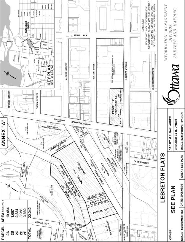
3. Guide the Environmental Assessment process for the downtown transit tunnel with respect to minimizing adverse impacts on the development potential and use of Parcel 2, as shown on the attached Annex “A,” in order to maximize the City’s opportunities to implement development and uses consistent with that shown in the DOUDS and, thereby address the City’s program/community needs for both the short and long-term in this area including, but not necessarily limited, to the following:
i. Transit and transportation requirements
ii. Municipal servicing requirements
iii. Parks and open space
iv. Housing First Policy
v. City Manager's mandate of leveraging assets
vi. Major downtown program property requirements
vii. Intensification
viii. Community gardens;
4. Once the downtown transit tunnel EA has better established the potential of the City-owned Parcels 1 and 2, as shown on the attached Annex “A”, to meet the City’s program/community needs described above, undertake any amendments that may be required to Parcel 1 and 2's Official Plan land use designations and/or comprehensive Zoning By-law codes in order to help fulfill those needs.