Report to/Rapport au :
Agriculture and Rural Affairs Committee
Comité d'agriculture et des questions rurales
and Council / et au Conseil
12 November 2008 / le 12
novembre 2008
Submitted by/Soumis par : Nancy Schepers, Deputy City Manager/
Directrice municipale adjointe,
Infrastructure Services and Community
Sustainability/
Services d’infrastructure et Viabilité des
collectivités
Contact Person/Personne ressource : Danny Page,
Acting Manager/
Gestionnaire intérimaire, Development
Approvals/
Approbation des demandes d'aménagement,
Planning Branch/
Direction de l’urbanisme
(613) 580-2424, 27595 Danny.Page@ottawa.ca
|
SUBJECT: |
ZONING - 1120 MaNotick station road (file no. D02-02-08-0076) |
|
|
|
|
OBJET : |
REPORT RECOMMENDATIONS
That the Agriculture
and Rural Affairs Committee recommend Council:
1. Approve
an amendment to Zoning By-law 2008-250 to change the zoning of part of 1120
Manotick Station Road from Rural Residential Subzone 2 (RR2) and Rural Countryside Zone (RU) to Rural
Residential Subzone 2 Exception 620r (RR2 [620r]) and Rural Residential Subzone
2 Exception XXXr (RR2 [XXXr]) as shown on Document 1 and as detailed in
Document 2.
2. Approve an amendment to the former
Township of Osgoode Zoning By-law to change the zoning of part of 1120 Manotick
Station Road from Rural
Zone (RU), Hazard Zone (HAZ) and Country Estate (CE) to Country Estate Zone
Exception 360(CE[360]) and Country Estate Zone Exception xxx (CE[xxx]) as shown on Document 1 and as detailed in
Document 2.
RECOMMANDATIONS DU RAPPORT
Que le Comité de recommande au Conseil
1.
D’approuver une modification
au Règlement de zonage 2008-250 de la Ville d’Ottawa visant à faire passer la
désignation de zonage d’une partie de la propriété située au 1120, chemin
Manotick Station, de Sous-zone résidentielle rurale 2 (RR2) et Zone d’espace
rural (RU) à Sous-zone résidentielle rurale 2, Exception 620r (RR2 [620r])
et Sous-zone résidentielle rurale 2, Exception XXXr (RR2 [XXXr]), comme
l’illustre le document 1 et le précise le document 2.
2.
D’approuver une modification
au Règlement de zonage de l’ancien Canton d’Osgoode visant à faire passer la
désignation de zonage d’une partie du 1120, chemin Manotick Station, de
Zone rurale (RU), Zone à risque (HAZ) et Zone de domaine de campagne (CE) à
Zone de domaine de campagne, Exception 360 (CE[360]) et Zone de domaine de
campagne, Exception xxx (CE[xxx]), comme l’illustre le document 1 et le précise
le document 2.
BACKGROUND
The subject site is located at 1120 Manotick Station
Road and is situated southwest of the intersection of Manotick Station Road and
Mitch Owens Road. The site is Phase 8
of the draft approved plan of subdivision known as Rideau Forest. This
Phase has an area of 34 hectares. An
existing estate lot residential development abuts the property to the west.
The subdivision and
original Zoning By-law amendment applications for Rideau Forest – Phases 7
to 11 were filed prior to July 23, 2003 and consequently, were reviewed on the
basis of the former Regional and Osgoode Official Plans. As such, this permits
the applicant to have a reduced lot size of less than 0.8 hectares if a
recreational facility such as a special landscape feature is provided. A 13-hectare nature preserve was provided to
meet this requirement. The development also complies with the policy requiring
an average lot size of not less than 0.8 hectares per dwelling unit when
averaged over all the land in the development.
The engineering reports, including the Hydrogeological Report, that were
provided as part of draft approval of subdivision established that the
servicing needs could be met with the reduced lot size. However, in accordance
with the Official Plan, a Performance Report must be submitted to demonstrate
that the previous subdivision phase is performing as predicted in the
Hydrogeological Report. The Performance Report is a pre-requisite of
registration of Phase 8.
The draft plan of
subdivision for Rideau Forest - Phases 7 to 11 was approved August 25, 2006. In
February 2007, Council approved the Zoning By-law amendment required for the
first phase, Phase 7, to proceed with registration. Phase 7 was registered in
December 2007 and construction has subsequently begun.
Purpose of
Zoning Amendment
An amendment to the
Zoning By-laws to permit country estate lot development is one of the
conditions of draft plan of subdivision approval that is to be satisfied prior
to commencement of each of the phases of the Rideau Forest Subdivision.
Changes to Zoning By-law 2008-250
The applicant is requesting a change under
Zoning By-law 2008-250 from Rural Countryside Zone (RU) to Rural Residential
Exception Zone (RR2 [XXXr]) and from Rural Residential Subzone 2 (RR2) to Rural
Residential Exception Zone (RR2 [XXXr]).
The Rural Countryside Zone (RU) permits
the development of detached
dwellings on country residential lots created by severance having a minimum lot
area of 0.8 hectares and a minimum lot frontage of 50 metres. The purpose of
the Rural Residential Zone (RR) is to permit residential development in planned
subdivisions. The Rural Residential Subzone 2 (RR2) similarly permits
development of detached dwellings on lots having the same lot area and
frontage. The amendment is required to permit development of single detached
dwellings on a smaller minimum lot size within a planned subdivision. The exception would reduce the minimum lot
frontage from 50 metres to 43 metres and the minimum lot area from 0.8 hectares
to 0.59 hectares.
Changes to the former Township of Osgoode
Zoning By-law
The applicant is requesting a change under the former
Township of Osgoode Zoning By-law from Rural (RU), Hazard (HAZ) and Country
Estate (CE) to Country Estate Exception Zone (CE[XXXr]). The Rural (RU) zone
permits the development of single detached dwellings on lots having a minimum
lot area of 10.0 hectares and a minimum lot frontage of 182.8 metres. The
Hazard (HAZ) zone is limited to agricultural, forestry, game preserve,
sanctuary and park uses.
The amendment is required to permit development of
single detached dwellings on country estate lots. The Country Estate (CE) zone
permits development of single detached dwellings on lots having a minimum lot
frontage of 54 metres and a minimum lot area of 0.8 hectares. The exception
would reduce the minimum lot frontage from 54 metres to 43 metres, and the
minimum lot area from 0.8 to 0.59 hectares.
The
amendment also includes a parcel of land within a future phase of the Rideau
Forest North Subdivision. On June 18, 2008, the Committee of Adjustment granted
approval to Consent and Minor Variance applications to convey a portion of land
within the future phase of the Rideau Forest Subdivision to 5809 Lancer Avenue,
which is within Phase 7. The parcel is zoned RU under Zoning By-law 2008-250
and RU and HAZ under the former Township of Osgoode Zoning By-law, and will be
changed to RR2[620r] and CE[360], respectively. The minor variance application was necessary to enable the
development of a two-storey dwelling on these lands to proceed before the
zoning was amended. The subject Zoning By-law amendment would bring the parcel
into conformity with the existing Zoning By-law designation for Phase 7.
DISCUSSION
Official Plan
The subject site is designated as ‘Rural Natural
Features’ under the Official Plan as is most of the Rideau Forest Subdivision,
including the previously registered phase. The purpose of this designation is
to protect locally significant natural areas and the City’s tree cover.
Uses permitted in the General Rural Area may be
permitted on land designated Rural Natural Features. The General Rural Area
allows for a variety of uses including country estate lot subdivisions,
subject to a rezoning and compliance with the applicable policies. The
policies support subdivision development in the form of country estate lots
within the Rural Natural Feature designation as long as it is sensitive to the
surrounding landscape and environment. Any proposed development is to be
supported by an Environmental Impact Statement (EIS), which must demonstrate
that development can occur without adversely impacting the recognized
ecological features and their functions.
The area encompassing the Rideau Forest - Phases 7 to
11 subdivision underwent extensive review as part of the subdivision process
before draft approval. The environmental sensitivity of the Manotick Station
Natural Area has been documented in the EIS that was provided during the
subdivision review process. It acknowledged that the proposed development would
have some impact upon natural functions of this area, however the impacts could
be minimized through mitigating measures. Conditions were imposed within the
draft approved plan of subdivision to ensure the appropriate mitigating
measures are implemented prior to, during and after site development.
Conclusion
The proposed Zoning By-law amendment is consistent
with the country estate residential development that has occurred over the
years in this area of the former Township of Osgoode, including within previous
phases of Rideau Forest. The amendment
complies with the official Plan policies in place at the time of draft plan of
subdivision approval, which permitted country estate residential development on
lots smaller than 0.8 hectares, subject to the provision of a special landscape
feature, the achievement of an overall average lot size of not less than
0.8 hectares, and the establishment through proper engineering analysis
that the servicing requirements can be met. The Department recommends approval of an amendment to the
Zoning By-laws to permit the country estate lot development of Phase 8 of the Rideau
Forest subdivision, as outlined in Document 2.
ENVIRONMENTAL IMPLICATIONS
The environmental sensitivity of the Manotick Station Natural Area has been documented in an Environmental Impact Statement. Draft subdivision conditions have been imposed to ensure that appropriate mitigating measures are implemented prior to, during and after the development of the site.
CONSULTATION
Notice of this application was carried out in accordance with the City's Public Notification and Consultation Policy. The Ward Councillor is aware of this application and the staff recommendation. Details of the public consultation can be found in Document 3.
FINANCIAL IMPLICATIONS
APPLICATION PROCESS TIMELINE STATUS
The application was not processed by the "On Time Decision Date" established for the processing of Zoning By-law amendments due to the issues associated with the required engineering related submissions.
SUPPORTING DOCUMENTATION
Document 1 Location Map
Document 2 Details of Recommended Zoning
Document 3 Consultation Details
DISPOSITION
City Clerk’s Branch, Council and Committee Services to notify the owner, Ken Gordon P.O. Box 1172, Manotick, ON K0A 2N0; applicant, Bliss Edwards, J.L. Richards & Associates Ltd., 864 Lady Ellen Place, Ottawa, ON K1Z 5M2; OttawaScene.com, 174 Colonnade Road, Unit #33, Ottawa, ON K2E 7J5; Ghislain Lamarche, Program Manager, Assessment, Financial Services Branch (Mail Code: 26-76) of City Council’s decision.
Infrastructure Services and Community Sustainability Department to prepare the implementing by-law, forward to Legal Services Branch and undertake the statutory notification.
Legal Services Branch to forward the implementing by-law to City Council.
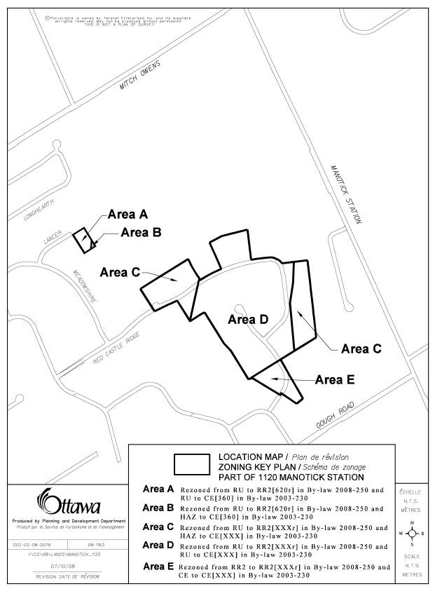 LOCATION MAP DOCUMENT
1
LOCATION MAP DOCUMENT
1
DETAILS OF RECOMMENDED ZONING DOCUMENT 2
Proposed
Changes to the Comprehensive Zoning By-law
- The subject lands, being part of 1120 Manotick Station Road, Block 58 and 60 and part of Block 59 of Plan 4M-850 and part of Lot 4 Concession 2 shall be rezoned from RU and RR2 to RR2[620r] and RR2 [XXXr] as shown on Document 1.
- Section 240 Rural Exceptions will be amended by adding a new Exception [XXXr] including the following provisions:
-
minimum lot width is 43 m
- minimum lot area is 0.59 hectares
Proposed
Changes to By-law the former Township of Osgoode Zoning By-law 2003-230
- The subject lands, being part of 1120 Manotick Station Road, Block 58 and 60 and part of Block 59 of Plan 4M-850 and part of Lot 4 Concession 2 shall be rezoned from RU, HAZ and CE to CE[360] and CE[xxx] as shown on Document 1.
- Section 124, Table 33 will be amended by adding a new Exception [xxx] including the following provisions:
-
minimum lot width is 43 m
- minimum lot area is 0.59 hectares
CONSULTATION DETAILS DOCUMENT
3
NOTIFICATION AND CONSULTATION PROCESS
Notification and public consultation was undertaken in accordance with the Public Notification and Public Consultation Policy approved by City Council for Zoning By-law amendments.
SUMMARY OF PUBLIC COMMENTS
Three members of the public provided comments. The following is a summary of comments received and the staff response:
- Traffic related concerns were expressed in relation
to increased traffic in the area and access to Mitch Owens Road and
whether a traffic light is planned at the intersection of Manotick Station
Road and Mitch Owens Road. Also, it was questioned whether the subdivision
will have any new connections to Mitch Owens Road.
Staff reply: A
traffic study was provided and reviewed during the draft approval of the
Subdivision. No modifications to the existing road networks were warranted.
However, staff has been monitoring the referenced intersection independent of
the proposed development and traffic lights have been planned in the Long Range
Financial Plan to be installed by the City in 2010, subject to Council approval
of funding. The draft subdivision approval of Rideau Forest Phase 7-11 does not
propose any new connections to Mitch Owens Road.
- Questions were
received regarding the former Township of Osgoode Hazard zone, the
presence of organic soils (peat) in Phase 8, and the appropriateness of
homes being built in this area. Also, it was suggested that the natural
feature within the subject lands should be preserved and the area of peat
should be surveyed and kept as a nature preserve.
Staff reply: The
draft plan of subdivision for Rideau Forest Phases 7 to 11 was draft approved
August 25, 2006. The area underwent extensive review as part of the subdivision
process before approval. Staff and the developer had regard to the 'Hazard'
zoning, in this particular case, to ensure that the lands can indeed support
country estate lots. Development is permitted in these areas in compliance with
the Official Plan Policies. The policies allow for development in areas where
'organic soils' have been identified with the support of a Geotechnical Report
indicating that the soils are suitable or can be made suitable for development.
The Geotechnical Report in support
of Phase 8 of the Rideau Forest Subdivision has been provided and has
demonstrated how organic soils will be managed, removed if needed and replaced
with engineered fill. Staff have agreed with the report.
The environmental sensitivity of
the Manotick Station Natural Area has
been documented in an Environmental Impact Statement which was provided during
the subdivision review process.
While the report acknowledged that
the proposed development will have some impact upon natural functions of this
natural area, the impacts nonetheless could be minimized through mitigating
measures.
Conditions were imposed within the
Draft Approved Plan of Subdivision to ensure the appropriate mitigating
measures are implemented prior to, during and after site development.
ADVISORY COMMITTEE COMMENTS
Ottawa Forests and Greenspace Advisory Committee (OFGAC)
OFGAC had no objection to the requested zoning amendment. However, the Committee did provide comments on issues that should be reviewed or addressed before building approvals are concluded. They are as follows.
1. The impact of building(s) on wetlands and forest habitats.
2. The identification of the tree inventory. The area currently appears to be a mixed forest with maples, birch, some coniferous and a significant percentage of ash trees.
3. The potential impact of the Emerald Ash Borer. Given the percentage of ash trees in the forested area, it needs to be confirmed that this area is free of the Emerald Ash Borer. If there is evidence of an infestation, restrictions in the felling of trees and transportation of wood products must be observed in order to contain the infestation. The site plan should then address how the forest will be managed to offset any damage done by the Emerald Ash Borer.
Also, it should be noted that residents (and
builders) within Rideau Forest are encouraged to preserve the natural forested
areas.
Staff reply: These issues will be reviewed
during the clearance of draft conditions for registration of Phase 8 of the
subdivision. A tree preservation plan must be provided as a condition of
approval. A condition will be added in the subdivision agreement regarding the
mitigating measures to combat the Emerald Ash Borer. As noted
above, based on the conclusions of the Environmental Impact Statement
conditions were imposed within the Draft Approved Plan of Subdivision to ensure
the appropriate mitigating measures are implemented prior to, during and after
site development.