Report to/Rapport au :
Planning and Environment Committee
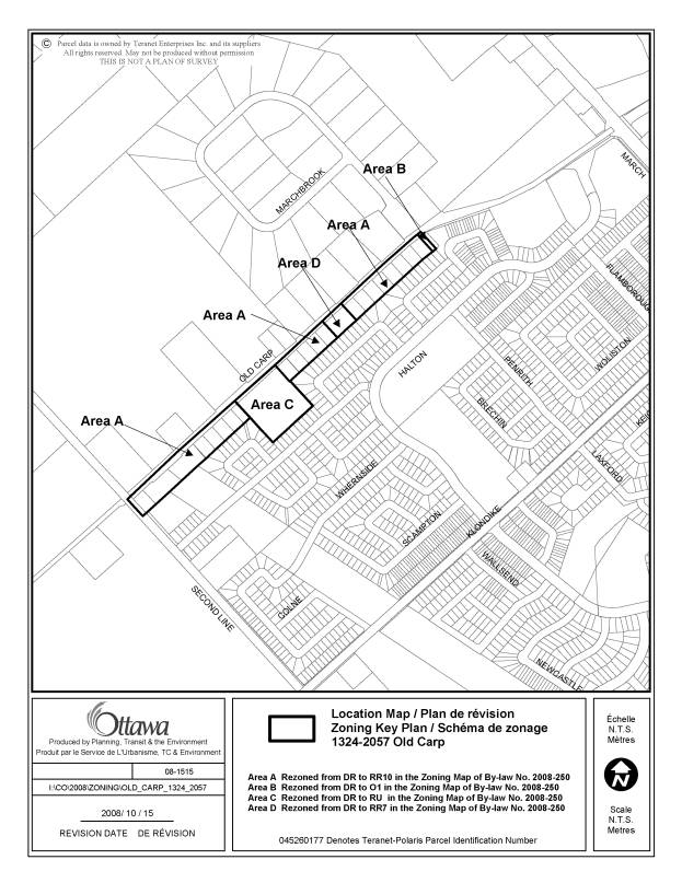
Comité de l'urbanisme et de l'environnement
and / et
Agriculture and Rural Affairs Committee
Comité de l'agriculture et des questions rurales
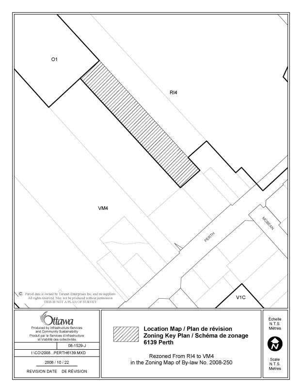
and Council / et au Conseil
November 6, 2008/le 06 novembre 2008
Submitted by/Soumis par : Nancy Schepers, Deputy City Manager
Directrice municipale adjointe,
Infrastructure Services and
Community Sustainability
Services d’infrastructure et
Viabilité des collectivités
Contact Person/Personne-ressource : Richard Kilstrom, Manager/Gestionnaire, Community Planning and Design/Aménagement et conception communautaire, Planning Branch/
Direction de l’urbanisme
(613)
580-2424 x22653, Richard.Kilstrom@ottawa.ca
SUBJECT:
|
COMPREHENSIVE ZONING BY-LAW 2008-250:
ANOMALIES AND MINOR CORRECTION - THIRD REPORT |
|
|
|
OBJET :
|
RÈGLEMENT
DE ZONAGE 2008-250 : ANOMALIES ET CORRECTIONS MINEURES – TROISIÈME RAPPORT |
REPORT RECOMMENDATIONS
1. That
Planning and Environment Committee recommend that Council approve the amendments
recommended in Column 4 of Document 1, to correct anomalies in Zoning By-law
2008-250; and
2. That Agriculture and Rural Affairs Committee recommend that Council approve the amendments recommended in Column 4 of Document 2, to correct anomalies in Zoning By-law 2008-250.
RECOMMANDATIONS DU RAPPORT
1. Que
le Comité de l’urbanisme et de l’environnement recommande au Conseil
d’approuver les modifications recommandées dans la Colonne 4 du Document 1 afin
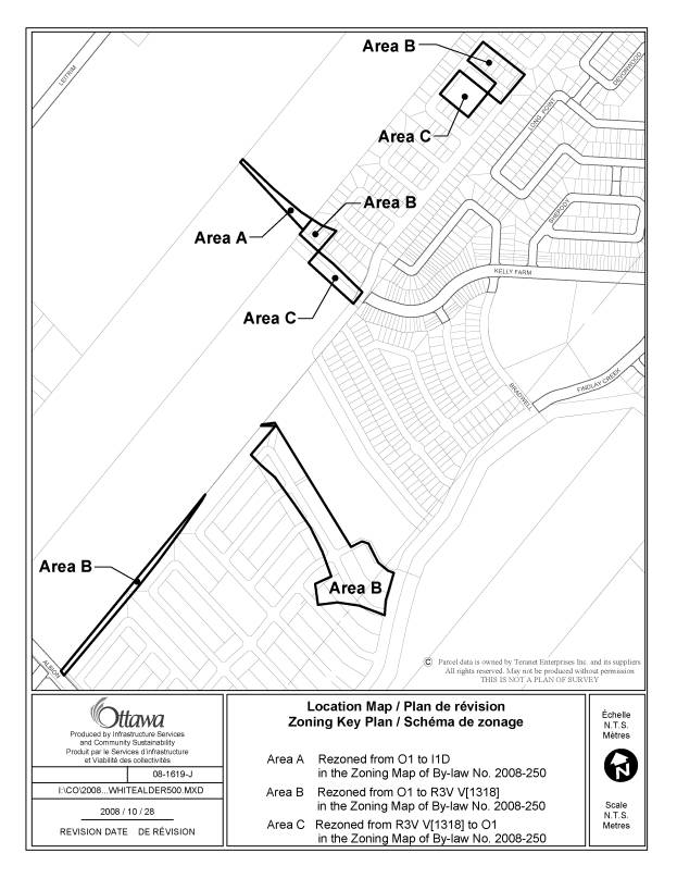
de corriger des anomalies dans le Règlement de zonage 2008-250;
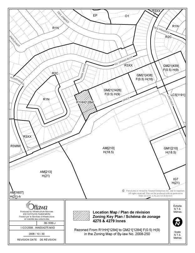
2. Que
le Comité de l’agriculture et des affaires rurales recommande au Conseil
d’approuver les modifications recommandées dans la Colonne 4 du Document 2 afin
de corriger des anomalies dans le Règlement de zonage 2008-250.
BACKGROUND
On June 25, 2008 City Council adopted the new Comprehensive Zoning By-law 2008-250 which affects all properties within Ottawa. By-law 2008-250 replaces the 36 Zoning By laws of the former municipalities that were amalgamated in 2001. Since the adoption of the Zoning By-law, staff have been identifying anomalies that require correction, and reports to correct the anomalies are being forwarded to Committee and Council on a regular basis. This report details recommended amendments to correct a number of the identified anomalies.
DISCUSSION
Since
the adoption of the Zoning By-law 2008-250, staff have monitored the new by-law
and have identified certain anomalies that are being recommended for
correction. Documents 1 and 2 provide staff recommendations to Planning and
Environment Committee and Agriculture and Rural Affairs Committee on the
anomalies, and include details of the recommended amendments in the urban area
in Column 4 of Document 1, and amendments to the rural or greenbelt areas in
Column 4 of Document 2. Document 3
contains the maps showing the location of zoning map corrections. The
amendments are intended to correct mapping and text reference errors in the
implementation of Council-approved changes which were not accurately reflected
in the Comprehensive Zoning By-law.
Further, at their meeting of August 21, 2008, in considering the first anomaly report for By‑law 2008-250 with respect to proposed changes to 2485 Carp Road; the Agriculture and Rural Affairs Committee recommended that Council hold off approving the recommended changes identified in Item 2 of Document 2 of report ACS2008-PTE-PLA-0176, in order for staff to review whether or not a “conservation use” definition should be inserted into the Zoning By-law. Specifically, Mr. Gary Marshall in speaking to Committee that day, suggested that the former West Carleton definition be adopted.
The definition in the former West Carleton Zoning By-law for conservation use was as follows:
"Conservation use" means the maintenance of the natural environment for the purposes of preservation, research, observation and outdoor uses such as hiking, hunting and fishing. This definition may include the erection and use of trail shelters and other similar structures ancillary to the foregoing uses but shall not include the use of a dwelling house, a mobile home, a tourist vehicle or a tourist trailer".
Under the new Comprehensive Zoning By-law, the corresponding land use is now called an "Environmental preserve and education area". Not all land uses are defined in zoning by-laws as a definition is only required if the natural meaning of the words are not clear.
This particular land use is not defined in By-law 2008-250 and it is felt that it is not necessary to provide a definition for this use, nor is it necessary to add a new land use, that being "Conservation use" since there is a new land use replacing this term. Document 2 does propose to add the land use "Environmental preserve and education area" to the permitted uses for 2485 Carp Road, which replaces the previous "conservation use" permitted on these lands, but without the need for a definition.
CONSULTATION
Notice of the public meeting to deal with these anomalies and corrections was provided in The Citizen and Le Droit, with a listing of the addresses and provisions subject to correction. As well, interested parties have been notified by first class or electronic mail.
FINANCIAL IMPLICATIONS
SUPPORTING DOCUMENTATION
Document
1 List of Anomalies and Modifications
to Zoning By-law 2008-250 for consideration by Planning and Environment
Committee
Document 2 List of Anomalies and Modifications to Zoning By-law 2008-250
for consideration by Agriculture and Rural Affairs Committee
Document 3 Location Maps
DISPOSITION
Infrastructure
Services and Community Sustainability Department to prepare the implementing
by-law, forward it to Legal Services Branch
Legal
Services Branch to bring forward report and by-law to Ontario Municipal Board.
LIST OF ANOMALIES
AND MODIFICATIONS
TO ZONING BY-LAW
2008-250 FOR CONSIDERATION
BY PLANNING AND ENVIRONMENT COMMITTEE DOCUMENT 1
|
Item No. |
Reference |
Objective of Amendment |
Proposed Amendment |
|
1 |
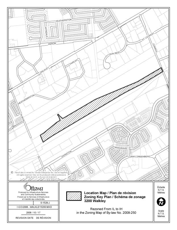
3200 Walkley Road |
The zoning of the Walkley Yards, the area between Albion
and Conroy which under the former Ottawa Zoning By-law was zoned for Heavy
Industrial uses, was inadvertenly changed from IH - Heavy Industrial to IL -
Light Industrial, between the May 2007 draft of the zoning by-law and the
final adopting by-law. |
Change the zoning map to rezone the lands from IL to IH,
as shown in Document 3 |
|
2 |
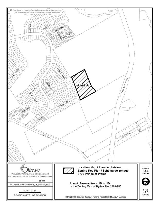
3702 Prince of Wales Drive |
This portion of the existing cemetery lands is zoned I1B -
Minor Institutional, which does not recognize the current land use. The
remainder of the cemetery (3700 Prince of Wales) has been correctly zoned I1D
in a recent amendment, and this site should be placed in the same zoning. |
Change the zoning map to rezone the lands from I1B to I1D,
as shown in Document 3 |
|
3 |
Section 133 - Secondary Dwelling Units |
When the clauses detailing the interpretation of density
counts, including maximum number of units per hectare and maximum number of
dwelling units, secondary dwelling units and garden suites from such counts
were inadvertently deleted. To ensure the implementation of the secondary dwelling
unit report and zoning amendment, staff recommend a modification to Section
133, to specify that secondary dwelling units are excluded from any density
regulations and counts. |
Amend Section 133 to add a new clause (17) immediately
following clause (16), as follows: "(17) Secondary dwelling units must not be limited
by, nor included in, any density control requirement, including the maximum
number of dwelling units, or maximum unit per hectare." |
|
4 |
Exceptions to Section 125 (c) - Group Homes |
Exception zones were created or modified to include a
provision that indicates that "Section 125 (c) does not apply",
prior to revisions being made to Section 125. Paragraph (d) is the correct reference indicating that the
minimuim separation area does not apply. |
Modify Exceptions [6], [1115], [1269], [1338], [1339],
[1340], [1346] and [1347] to replace (c) with (d). |
|
5 |
Exception [1636] |
Exception [1636] should be revised to correct an anomaly
in a recent omnibus amendment by deleting the contents of Columns III and V,
and adding the words "Minimum front yard setback for a multiple attached
dwelling: 3 metres" to Column V. |
Delete the contents of Columns III and V of Exception
[1636], and add the words "Minimum front yard setback for a multiple
attached dwelling: 3 metres" to Column V |
|
6 |
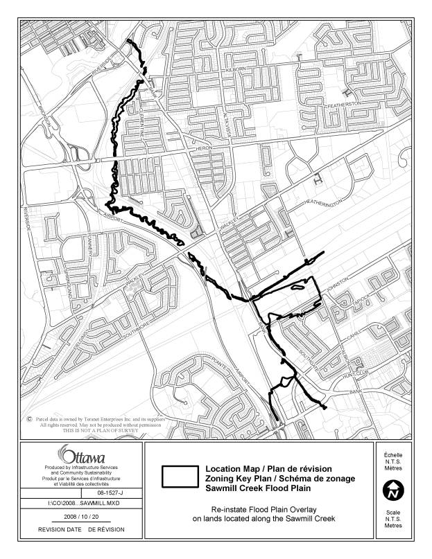
Sawmill Creek, from the Rideau River to Hunt Club Road |
The location of the floodplain overlay is missing from the
Sawmill Creek area, as it was not included in the floodplain data received
from the Rideau Valley Conservation Authority, since the mapping is part of
the separate Sawmill Creek Watershed study. The RVCA have advised the mapping
should have been included. The floodplain overlay is similar to that mapped
in the former Ottawa Zoning By-law. |
Re-instate the floodplain overlay, on the zoning map,as it
affects the lands located along the Sawmill Creek, as shown in Document 3. |
|
7 |
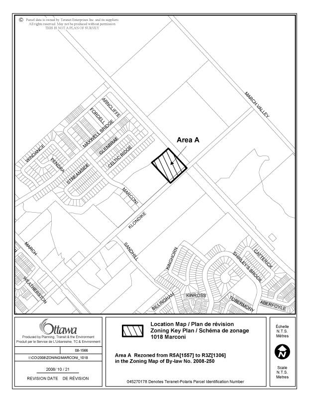
1018
Marconi Avenue |
Rezone the eastern portion of 1018 Marconi Avenue from the
current R5A[1557] to R3Z[1306] to implement By-law 2007-188 |
Change the zoning map to rezone the lands along the
eastern portion of 1018 Marconi Avenue from R5A[1557] to R3Z[1306], as shown
in Document 3 |
|
8 |
348 Woodroffe Avenue |
Delete incorrect reference to "tp"- (added in
error- this terminology is not used in new by-law) |
Change the zoning map to rezone the lands from R4D[984]-tp
to R4D[984], as shown in Document 3 |
|
9 |
4101 and 5025 Innovation Drive |
An error was made during the incorporation of By-law
2006-358 into former Kanata Zoning By-law 132-93 consolidation, and since
those consolidations were used during the preparation of the Comprehensive
Zoning By-law, the anomaly was replicated. As well, By-law 2006-358 permitted
a restaurant, and a restaurant- take out, and those are interpreted to mean a
restaurant is permitted under the Comprehensive Zoning By-law, but without a
drive through facility. |
Change the zoning map to rezone 4101 Innovation Drive from IG6[218]H(44) to IG6 H(44) and 5025
Innovation Drive from IG6 H(44) to IG6[218]H(44), as shown in Document 3. Add the following use as an additional permitted use in
Exception 218: restaurant. |
|
10 |
Part of 1941 Ogilvie Road |
In former Gloucester, these lands were zoned a Government
zone and had no height limit or floor area controls. Because they were
designated Employment area in the Official Plan, they were assigned an IL - light industrial zone with exception
[249] limiting the uses to office type development. The IL zone has a standard
height of 18 metres and it has been identified that there is an existing
building on site that is higher than this height. The zoning should reflect
this existing building height at 32 m. The density control in the IL zone
will continue to apply. |
Change the zoning map to rezone the lands from IL[249] to
IL[249]H(32), as shown in Document 3. |
|
11 |
20 Frank Nighbour Place |
The existing zoning in the former Kanata Zoning By-law
included a "f" suffix which indicated flood proofing requirements
within the flood fringe. While these requirements were orignially inserted
into exception [303] for this site, when a site specific amendment for this
property was approved, a new exception [1414] was created and the flood
proofing provisions should have been carried over since this was a site
specific amendment. |
Add the following to Column V of Exception [1414]: - for those lands located within the flood fringe, which
are defined as any lands at a ground elevation of 94.2 metres or less, the
following provisions apply: (1) all dwelling units, rooming units, secondary dwelling
units and garden suites and any related major building service such as
mechanical or electrical services, and all additions or alterations which
expand a non-complying building or structure must be at least 0.3 metres
above the regulatory flood level, and (2) all non-residential uses must be flood proofed to at
least the regulatory flood level of 94.4 metres G.S.C.D.. |
|
12 |
15 Frank Nighbor Place, 737 and 777 Silver Seven |
The existing zoning in the former Kanata Zoning By-law did
not include an "f" suffix on these properties, but they are
currently zoned with exception [303] which does carry over flood proofing
provisions but which should only apply to 50 Frank Nighbor Place, in addition
to 20 Frank Nighbor Place. |
Change the zoning map, as shown in Document 3, to rezone
the lands from IL6[303]H(30)-h to IL6[xxx]H(30)-h; an exception that
replicates the provisions of Exception [303], except for the flood proofing
provisions contained in exception [303]. |
|
13 |
613 Hazeldean Road |
These two small parcels of land are zoned AM7[1570]-h,
with a floodplain overlay. In the former Kanata zoning for these properties,
reference is made to applying the flood proofing measures once they are
removed from the floodplain after the "f" suffix is removed. This
provision was not reflected in exception [1570] in accordance with the site
specific amendment for these lands. |
Modify exception [1570] to: - add "[1570]-h" after the letters
"AM7", and - add the provision after the last provision in the
exception that states has the effect of inserting the following provision
upon removal of the flood plain overlay: " -the lands are located in the flood fringe, which
are defined as lands at a ground level elevation of 95.2 metres or less, and all permitted uses must be flood
proofed in accordance with the following provisions: (a) any building and related major building services such
as mechanical or electrical services, must be located at least 0.3 metres
above the regulatory flood level; (b) all residential and non-residential uses must be flood
proofed to 0.3 metres above the regulatory flood level" |
|
14 |
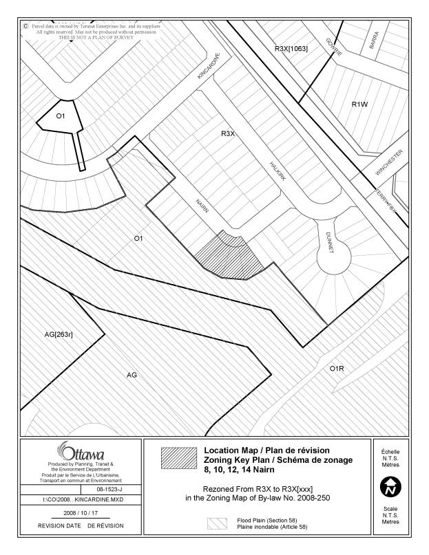
8, 10, 12 and 14 Nairn Street |
The area in Westcreek Meadows along parts of
Kincardine, Nairn and Dunnet, which
is now developed with detached and townhouse dwellings had an
"f"suffix under the former Kanata Zoning By-law indicating
flood-proofing measures applied. These were not carried over in the
Comprehensive Zoning By-law, however part of the lands should have retained the
flood proofing provisions as the lands are still within the flood fringe.
However, the rest of the area is no longer in the flood fringe and therefore
it is appropriate not to have applied the flood proofing measures to the
other lands. |
Change the zoning map affecting the lands to R3X[xxx], as
shown in Document 3, with the exception indicating the following: "-the lands are partially located in the flood
fringe, as defined by lands located at a ground elevation of 95.2 metres or
less, and all permitted uses must be flood-proofed in accordance with the
following provisions: (a) any dwelling unit and related major building services,
such as mechanical or electrical services, shall be located at least 0.3
metres above the regulatory flood level. (b) all residential uses must be flood proofed to 0.3
metres above the regulatory flood level. |
|
15 |
Section 3.(3) Non-Conformity and Non-Compliance |
Revise the wording to clarify the intent that all
buildings, structures and facilities are subject to these provisions
(including septic and other servicing systems) |
Revise Section 3.(3) to state "When a building,
structure, facility or otherwise, including septic and other servicing
systems, used in connection..." |
|
16 |
Section 198(9)(a) |
Delete "place of assembly" from TM9 Subzone
permitted uses, as it is redundant since this use is already permitted in the
TM primary zone |
Delete "place of assembly" from Section
198(9)(a) |
|
17 |
Section 204(7)(h) |
Revise wording to reflect the intent of the former By-law
142-93 for the Kanata Town Centre Special Employment Area. |
Delete the words "office is not a permitted primary
use on lots greater than 5500 m2 in area" and replace with
the words "maximum gross floor area of 5500 m2 is permitted
for office use that is the primary use of the lot". |
|
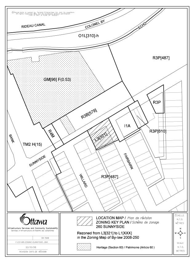
18 |
260 Sunnyside Avenue |
Rezone these lands from L3[321] to L1 with a new exception
to reflect the intent of the former Ottawa zoning. |
Rezone these lands from L3[321] to L1[xxx], as shown in
Document 3 , with a new exception that states "3 parking spaces to be
provided, each with a minimum width of 2.7 metres" |
|
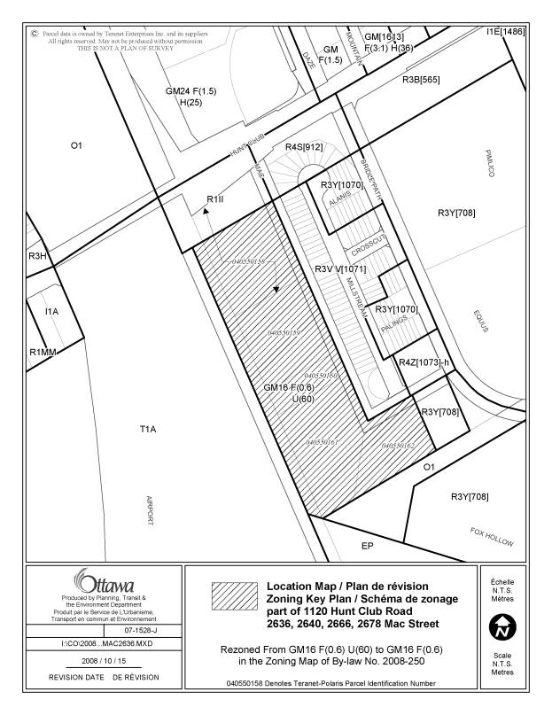
19 |
2636 Mac
Street |
The unit
per hectare suffix U(60) should be removed from the zoning map, as the U
suffix is no longer used. |
Amend the
zoning map, for 2636 Mac Street , as shown in Document 3, so that the zoning is GM16 F(0.6). |
|
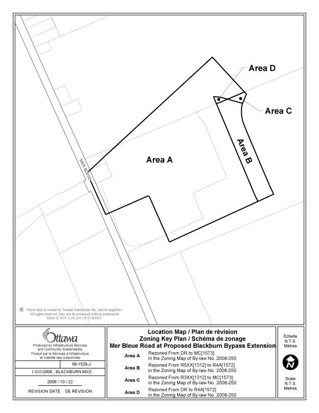
20 |
Mer Bleue
Road at Proposed Blackburn Bypass Extension |
Implement
amending By-law 2006-439 in the new Zoning By-law |
Change the zoning map to rezone the lands from partially DR, R5XX[1312] and
R3XX[1312] to MC[1573] and R4A[1572] as shown in Document 3. |
|
21 |
Section
106(5) |
Clarify
that the permission for small vehicle parking spaces only applies in the case
of a parking lot (4 or more parking spaces) |
Add
Section 106(5)(d) which states “the parking space must be located in a parking
lot” |
|
22 |
Residential
Zone Endnotes - interior side yard requirements on corner lots |
Where a
minimum total interior side yard setback has been noted in the Residential
Subzone Tables as "varies", it refers the reader to specified
Endnotes. The Endnotes apply a
minimum total interior side yard, with at least a specified amount per side
yard. This minimum is too large when
applied in its totality on the only one interior side yard on corner lots. Suggest
clarifying that the minimum required for the only interior side yard setback
on a corner lot is reduced by 50%, in recognition of the already larger
corner side yard requirment. |
Amend the
following Endnotes in Part 6 and listed below by revising and adding new
wording as detailed below. 1.Replace
the words “with no yard less than…” or “with one yard at least” with the
following: “…with one minimum yard, no less than…”; and 2. Adding
an additional sentence: “In the
case of a corner lot, the minimum required interior side yard setback equals
the minimum stated herein for one yard. Affects
Endnotes: R1 -
Endnotes 3, 5, 6, 7, 8, 10; Table 156
B R2 -
Endnotes 7, 8; Table 158 B R3 -
Endnotes 3, 4, 5, 6; Table 160 B R4 - Endnotes 5, 6, 7, 8; Table 162 B R5 -
Endnote 16; Table 164 B |
|
23 |
IL1
subzone - Kanata Town Centre, Hearst Way |
In the
IL1 Subzone, provisions (i) and (ii) of Sections 204 were intended to be
deleted since they do not reflect the current Kanata Town Centre provisions,
but a technical problem with the track changes tool to make changes to the
text meant that the words were not deleted
in the production of the final document. |
Delete
subclauses (i) and (ii) from Section 204(1)(a); and replace the word “does”
with “do”in Section 204 (1) (a). |
|
24 |
Part of
200 Besserer Street |
The
zoning boundary bisects this property - it should, in fact, follow the
property line between 200 and 222 Besserer Street |
Change the zoning map to rezone the lands from R5F S270 to R5F[986]H(36), as
shown in Document 3. |
|
25 |
Table 55
– Provisions for Accessory Uses, Buildings or Structures |
Clarify
intent that the minimum required setback of an accessory use, building, or
structure from a front lot line is the same as the setback required for the
principal dwelling |
Revise
wording of row (2) to state "Same as required for principal building” |
|
26 |
Table 65
- Permitted Projections Into Required Yards |
Specify
that uncovered, unenclosed features such as decks or platforms are not
subject to a setback, but only in cases where the walking surface is not
higher than 0.6 m above adjacent grade. This is intended to mirror the
building permit exemption for decks where the walking surface is 0.6m or less
above the adjacent grade. In all other cases, decks and platforms would be
subject to a setback. |
Revise
wording of Row (6)(a) to state that the required setback for “uncovered,
unenclosed features such as decks or platforms where the walking surface is
not higher than 0.6 m above adjacent grade- no limit” |
|
27 |
Exception
[1332], Stittsville Main Street |
Exception
[1332] which applies only to Stittsville Main Street is redundant as it
repeats the provisions already applicable to the TM9- Stittsville Main Street
Subzone |
Delete
the text of Exception [1332] in Section 239 and delete references to
Exception [1332] on Stittsville Main Street on the zoning maps, as shown in
Document 3 |
|
28 |
1491
Stittsville Main Street |
Property
is zoned TM[465] H(15), but should have been rezoned to TM9[465] H(11) as per
Council’s direction at the draft Zoning By-law public hearings (all of
Stittsville Main Street was to be zoned TM9 with a maximum 11 metre height).
This change will not affect the conformity of the existing development. |
Change the zoning map to rezone the lands from TM[465] H(15) to TM9[465]
H(11), as shown in Document 3. |
|
29 |
2298
Midway Avenue |
The site
is developed with a number of residential dwellings, of which the most
northern dwelling was not captured within the R3A zone that covers the
remainder of the site. |
This
anomaly was created during the development of former Ottawa’s Zoning By-law
93-98 and should be corrected to ensure that all of the dwellings at 2298
Midway are zoned in the same R3A subzone.
Amend the
zoning map to correct the anomaly, as shown in Document 3. |
|
30 |
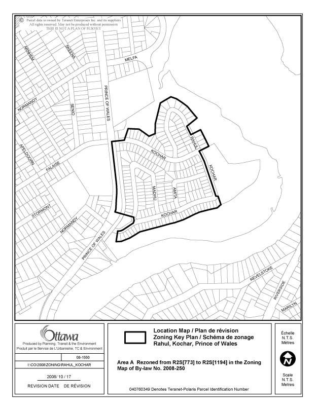
Area
zoned R2S[773] extending north to Rahul Crescent, south and east to the back
of lots fronting on Kochar Drive, and west to Prince of Wales Drive |
The
exception number should be [1194] and not [773] |
Amend the
zoning map to replace the exception number [773] with [1194] and apply to
lands zoned R2S and generally bounded by Rahual Crescent, Kochar Drive and
Prince of Wales Drive, as shown in Document 3. |
|
31 |
4401 and
4451 Fallowfield Road |
The
address noted in the Exception was changed following the adoption of the
site-specific zoning amendment, which meant that the original property (4401)
was permitted the additional uses, but the applicable site should be 4451
Fallowfield, the site that was severed post-site-specific zoning by-law
adoption |
Modify Exception [1219], Column III by
replacing the address 4401 Fallowfield with 4451 Fallowfield. |
|
32 |
Definition
of front lot line and side lot line |
Revise
definition of front and side lot line to clarify that a corner sight triangle
does not qualify as the front or side lot line. It was not intended that
these “corner cut-offs” would serve as the lot line |
Revise
the definition of front lot line and side lot line to specify that a corner
sight triangle does not qualify as the lot line. |
|
33 |
940
Belfast Road |
Former
Ottawa IL[272]F(1.0) zoning is not reflected in the new IL[446] zone. Revise
Exception [446] provisions to implement former Ottawa zoning (exception [446] applies only to this
site) |
Revise
Exception [446] to state as follows: 1.
Applicable Zone- IL[446] 2. Land
Uses Prohibited- medical facility 3.
Provisions- office limited to 2726 square metres |
|
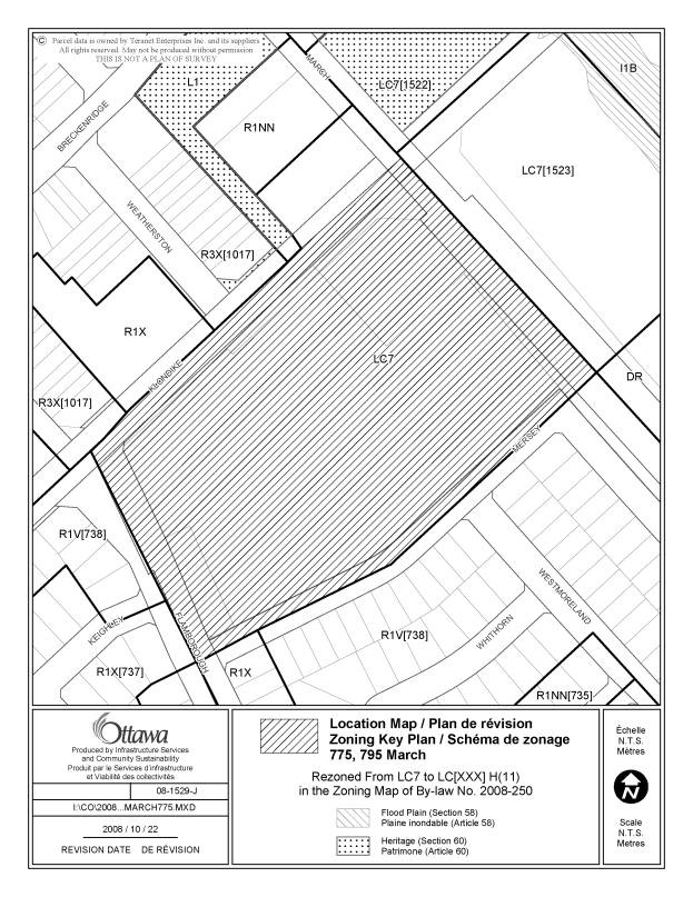
34 |
775-795
March Road |
This
anomaly correction is intended to address an appeal to Comprehensive Zoning
By-law 2008-250. Reinstate the LC H(11) zoning and applicable exception
provisions for this site shown in the March, 2008 version of the new Zoning
By-law, which reflects the former Kanata CG Zoning (note that the holding
symbol shown in the March, 2008 draft is no longer required as the holding
provisions were lifted from the former Kanata Zoning By-law by City Council;
also note that take-out restaurants with drive-throughs are permitted in the
former CG Zone for this property) |
|
|
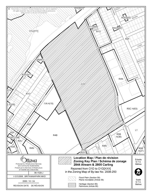
35 |
2844
Ahearn and 2805 Carling Britannia
Park (Tennis Centre West Ottawa) |
O1D
Zoning does not recognize the indoor (inflatable domed) tennis facility, whereas the former Ottawa LIB Zoning does
(recreational and athletic facility) |
Change the zoning map to rezone the lands from O1D to O1D-Exception[XXX], as
shown in Document 3, that
permits a "recreational and athletic facility" as an additional
permitted land use |
|
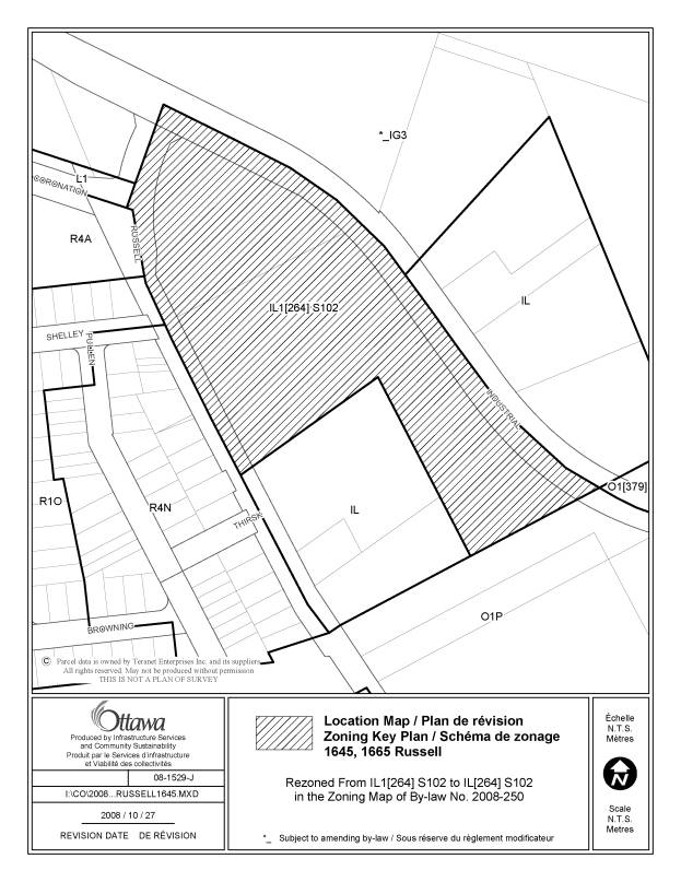
36 |
1645 and
1665 Russell Road |
Rezone
lands from IL1[264] S102 to IL[264] S102 as IL1 Subzone should not apply to
this site (applies only to Hearst Way lands) |
Change the zoning map to rezone the lands from IL1[264]S102 to IL[264] S102,
as shown in Document 3. |
|
37 |
Exception
[1627] |
Amend
Exception [1627] to permit a 0.0 metre setback from the lot line at a corner
sight triangle, as indicated in amending By-law 2008-209, approved in May,
2008 |
Amend
Exception [1627], Column V-Provisions to add the provision "0.0 metre
setback required from the lot line at a corner sight triangle" |
|
38 |
280
Didsbury Road/45 Goulbourn Forced Road |
The site
is zoned "IL7[1412] H(24)-h" in the Comprehensive Zoning By-law. A
Council decision for an Official Plan Amendment to the former City of Kanata
Town Centre Secondary Plan and Zoning By-law Amendment to the former City of
Kanata Zoning By-law to allow warehouse and retail store (and to address
other policy and zone provisions), was approved on August 29th, 2007 for
lands municipally known as 280 Didsbury Road/45 Goulbourn Forced Road. The Light
Industrial Subzone 7 (LI7) in the City's Comprehensive Zoning By-law does not
allow the full range of uses permitted by way of the above noted amendments. Specifically, the definition of a retail
use in the IL Subzone limits retail uses to the sale of appliances,
furniture, floor covering, paint and wall coverings, doors, windows, building
materials supplies, plumbing supplies, electrical supplies, heating and
cooling supplies, kitchen and bathroom cabinets and fixtures, specialty
tools, garden supplies and any products directly relating to the
foregoing. The
definition would limit the use of the land to a home improvement store,
which: i) is not
the developers vision for the lands, ii) is
not consistent with the current tenants on the lands, and iii) is contrary to
private covenants on the lands (restricting a home improvement store to avoid
a conflict with the Canadian Tire store to the north, along Campeau Drive). The main
or short-term concern is that the optical retail outlet could be considered
legal non-conforming, although transition policies in Section 9 of the new
Comprehensive By-law may provide some relief. |
Section
204(7)(d) is deleted and replaced with the following: - for a
retail store, the maximum gross floor area is 4,999 m2 The
following provision is added immediately following Section 204(7)(d) and the
subsequent sections are renumbered accordingly: - for a
retail store with a minimum gross floor area of 1,858 m2 and a
maximum gross floor area of 4,999 m2, there are no limitations on
the types of products sold except that supermarket and department store uses
are prohibited The
provisions for Exception [1412 ]are deleted and replaced with the following: - for a
retail store with a gross floor area of 0 to 600 m2 and 1,858 to
4,999 m2, there are no limitations on the types of products sold - a
maximum of one warehouse building is permitted with a maximum ground floor
area of 2,500 m2 - minimum
front and corner side yard setback is 3 m - minimum
interior side yard setback of 2 m, which may be reduced to 0 m abutting an
existing or future rapid transit corridor- minimum parking rate for warehouse
of 0.121 spaces per 100 m2 of gross floor area - no
parking lot landscape buffer required adjacent to an existing or future rapid
transit corridor - a
retail store with a gross floor area of 1,858 to 4,999 m2 is
permitted only after the ‘h’ symbol has been removed by City Council following
City approval of a traffic study that identifies the roadway/intersection
modifications required to support the scale of the proposed development |
|
39 |
4784 and
4786 Bank and 500 White Alder |
A number
of minor adjustments are required to the zoning map to reflect the approved
plan of subdivision and By-law 2006-380 and 2007-498. These changes are
primarily to reflect the proper locations for the open space zones. |
|
|
40 |
4275 and
4279 Innes Road |
Amend the
zoning maps to reflect the GM21[1284] F(0.5) H(9) zoning already shown for
these lands in Column II of Exception [1284], to implement the former
Cumberland zoning |
1.
Change the zoning map to rezone 4275 and 4279 Innes Road from R1HH[1284] to GM21[1284] F(0.5) H(9),
as shown in Document 3. 2. Revise
Section 239, Exception [1284], Column II to refer to GM21[1284] F(0.5) H(9). |
|
41 |
R4K
Subzone |
An error
occurred in the original draft of the Comprehensive Zoning By-law, wherein
the incorrect lot width and lot area were applied to multiple dwellings and
semi-detached dwellings. The R4K
Subzone should reflect the former Ottawa 93-98 R4F subzone, and not the
former R4E subzone. |
Amend the
R4K subzone, Column IV – Minimum Lot Width (m) to replace the “5.6” with
“4.5” and Column V – Minimum Lot Area (m2 ) to replace “170” with
“110”. |
LIST OF ANOMALIES
AND MODIFICATIONS
|
Item No. |
Reference |
Objective of Amendment |
Proposed Amendment |
|
1 |
Exception [588r] |
Add reference to V1H[588r] zone in Column II |
Add "V1H[588r]" to Column II of Exception [588r] |
|
2 |
South side of Old Carp Road, between March Road and Second Line Road, 1324 to 2057 Old Carp Road |
While the properties on the south side of Old Carp Road appear to be included in the urban area on Schedule B of the Official Plan, technically they are in the rural area. As a result, they were incorrectly zoned DR - development reserve, and should instead be zoned an appropriate rural zone or open space zone. |
Change the zoning map to rezone the lands from DR to RR7, RR10, RU and O1 as shown on the map in Document 3. |
|
3 |
Section
240, Exception [512r] |
Revise
Column II to refer to RR4[512r] instead of RR6[512r] to indicate the correct
applicable zoning category |
Revise
Column II of Exception [512r] to refer only to RR4[512r] |
|
4 |
2485 Carp
Road |
The owner
of the lands has appealed By-law 2008-250 to the Ontario Municipal Board. One
of the requests is to re-instate a number of uses previously permitted in the
zoning for the property under the West Carleton Zoning By-law. Staff concur
however these uses should be utilizing the new terminology, that is for
"conservation use", the equivalent term is now "environmental
preserve and education area"; for "forestry use", the new term
is "forestry operation"; and for” home occupation”, the term has
been changed to “home-based business”. |
Modify
exception [275r] to add the following
uses after "agricultural use": -
environmental preserve and education area -
forestry operation -
home-based business |
|
5 |
Purpose
Statements AG and RU
zones |
The
Official Plan sets out the conditions under which severances are
permitted. Some of the rural subzones
in the Comprehensive Zoning By-law reflect the lot sizes of existing lots,
and this has caused some confusion amongst the public, as the Official Plan
requires larger lot sizes when severances are contemplated. To help the
public understand better the lot sizes identified in the Comprehensive Zoning
By-law, and the lot sizes required for the creation of new lots in accordance
with the Official Plan, a note will be placed in the appropriate place in the
AG - agricultural and RU - rural countryside zones to ensure the public
refers to Official Plan policy with respect to severance policy. |
That
Table 211 - AG Zone Provisions be
amended by adding after the "0.2" in "(b) Minimum lot area
(ha)" under column "IV - Other uses", the followings words
"see provision 6 below" That
Section 211 be amended to add a new provision 6 as follows: (6) The
minimum lot area stated reflects that of many existing smaller sized
lots. New residential lot severances
are only permitted for an existing residence made surplus to a farming
operation, as per Official Plan requirements, and as such will have a minimum
lot area of 0.4 ha. That
Table 227 - RU Zone Provisions be amended by adding after the "0.8"
in "(b) Minimum lot area (ha)" under column "IV - Other
uses", the followings words "see provision 6 below" That
Section 227 be amended to add a new provision 6 as follows: (6) The
minimum lot area for a lot created by a consent application (severance
process) is guided by Official Plan policy that requires a minimum lot area
of 0.8 ha for the severed lot and 10.0 ha for the retained lot. One lot severance only is permitted. |
|
6 |
6139
Perth Street (Village of Richmond) |
Rezone
the eastern portion of this site to VM4 - Village Mixed Use to eliminate an
anomaly that exists under both the former Goulbourn and new Zoning By-laws
(lands are now zoned RI4- Rural Institutional, but have been approved for
residential development). The remainder of the site is zoned VM4. |
Change the zoning map to rezone the lands from RI4 to VM4 |
|
7 |
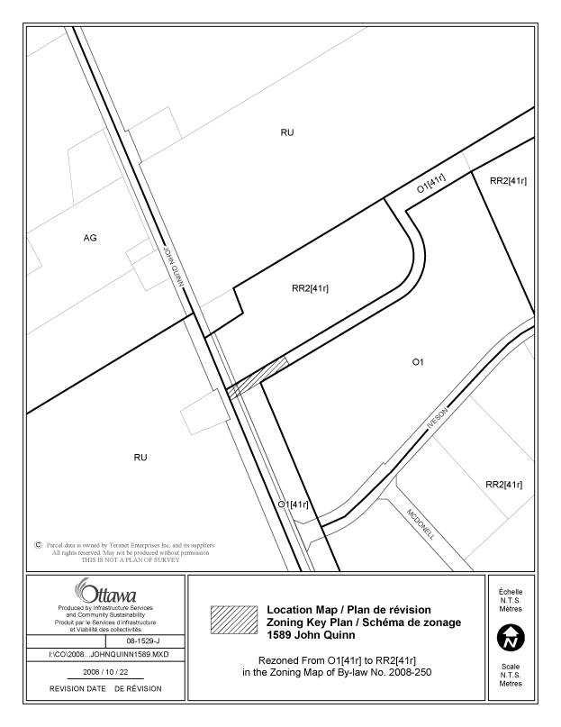
1589 John
Quinn Road |
A small
area of land that was originally part of a subdivision’s open space buffer
(riding path) was sold to the owner of the adjacent property at 1589 John
Quinn Road by the former Township of Osgoode. Consequently, this small area
of land was intended to be used in conjunction with the dwelling and should
be in the same RR2[41r] zone as the dwelling, instead of in an O1[41r] zone
as is the remainder of the buffer |
Change the zoning map to rezone the lands from O1[41r] to RR2[41r] |
|
8 |
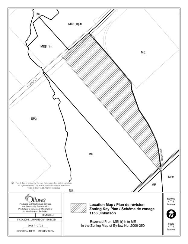
1156
Jinkinson Road |
Henderson
Quarry is licensed, and the license and rezoning applications were supported
with an EIS. Consequently, the holding symbol and conditions have been
fulfilled and are no longer required and the site can be placed in an ME
Zone. |
Change the zoning map to rezone the lands from ME[1r]-h to ME |
|
9 |
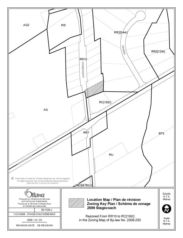
2599
Stagecoach Road |
Rezone
lands from RR10 to RC[192r] as per motion passed at A.R.A.C. to reflect the V
Zoning under the previous Osgoode Zoning By-law (an application to expand
Osgoode Tire Shop to the south onto these lands has been submitted- existing
business is already zoned RC[192r]) |
Change the zoning map to rezone the lands from RR10 to RC[192r] |
|
10 |
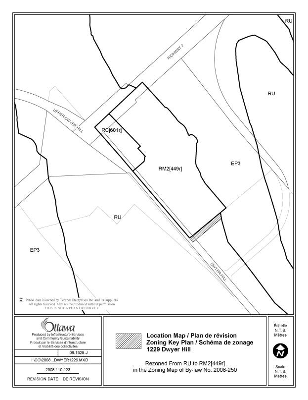
1229
Dwyer Hill Road |
Adjust
the RM2[449r] zoning boundary to reflect the boundary in the former Goulbourn
Zoning By-law. The Comprehensive Zoning By-law does not capture a small area
of the south portion of the site. |
Change the zoning map to revise the lands’ RM2[449r] southern zoning
boundary to reflect former Goulbourn zoning boundary. |
|
11 |
5736 Bank
Street |
Narrow
strip of land fronting on Bank Street now zoned DR1 should be zoned ME2 as is
the remainder of this lot. |
Change the zoning map to rezone the lands entirely to ME2 |
|
12 |
RC11
Subzone, Table 218C, Row (e) |
Revise
the RC11 Subzone minimum corner side yard setback requirement to state
"6 metres" instead of "16 metres" to correct a
typographical error (6 metres reflects the former Goulbourn C- General
Commercial Zone requirement) |
Amend
Table 218C, Row (e), minimum corner side yard setback, to state "6
metres". |
|
13 |
Lands
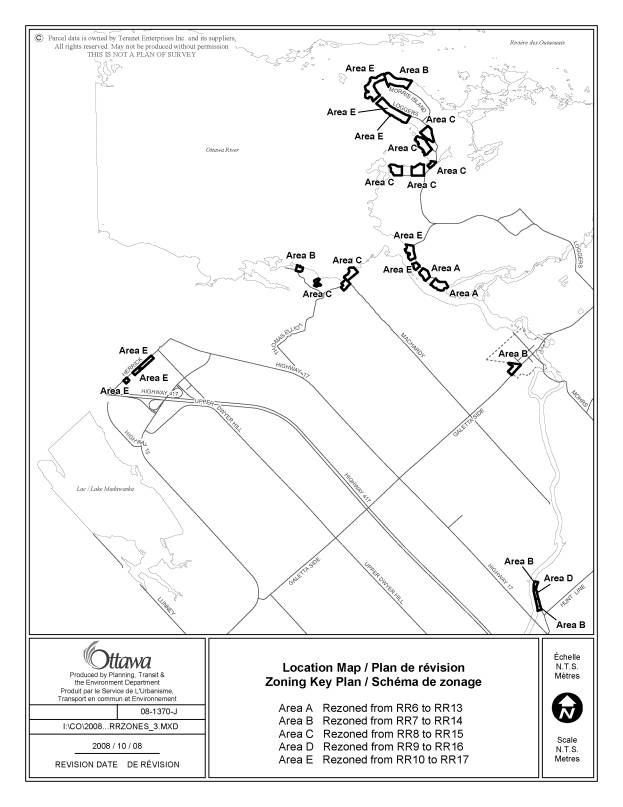
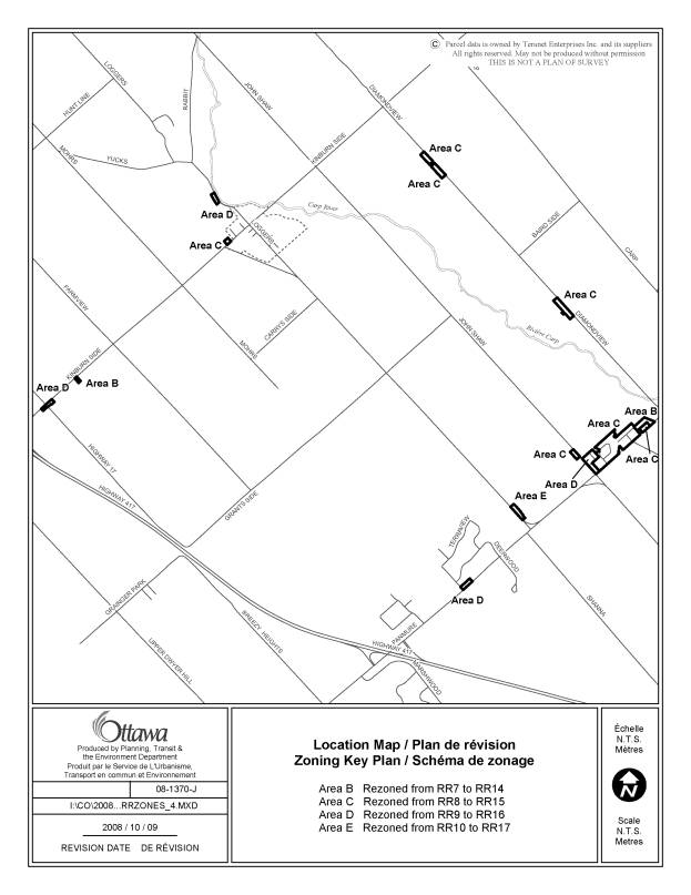
zoned Rural Residential, RR6, RR7, RR8, RR9 and RR10 subzones in Ward 5 (West
Carleton) See
Document 3 affected maps for West Carleton |
The
former West Carleton Zoning By-law had a provision (Section 16d) for
undersized lot areas and lot frontages, whereby minimum interior side yard
requirements were smaller and maximum lot coverages larger than the former
West Carleton standard RR and RL zone requirements, in order to accommodate
development on smaller actual lot sizes. While
this special provision was eliminated through the creation of the harmonized
new RR zones, lots were placed into subzones that generally reflected the
size of existing lots. This
affects principally the RR6, RR7 and RR 8 zones, and to a lesser extent the
RR9 and RR10 subzones in West Carleton. Regardless, it is felt that it would
be appropriate to just reinstate the interior side yard setbacks and lot
coverages as they previously existed in former West Carleton RR and RL zones. It should
be noted that while the interior side yard requirement will be reduced and
maximum lot coverage will increase, the front yard and corner side yard
setbacks will retain the smaller harmonized setbacks for the front yard and
corner side yard, and in one case, for the rear yard. The reason for this is
that many of these lots are affected by the larger watercourse setback in
former West Carleton that now applies city wide, and the harmonized front
yard, corner side yard and rear yard is less than what it was under former
West Carleton, thus providing more flexibility for building siting in order
to meet the 30 or 15 metre watercourse setback. |
Create a
new RR13 subzone which is identical to the RR6 subzone except that: - the
minimum front yard setback is 9 m - the
minimum interior side yard setback is 3 m - the
maximum lot coverage is 20% Create a
new RR14 subzone which is identical to subzone RR7 except that: - the
minimum interior sideyard setback is 3 m - the
maximum lot coverage is 20 m Create a
new RR15 subzone which is identical to the RR8 subzone except that: - the
minimum interior side yard setback is 3 m - maximum lot coverage is 20 % Create
new RR16 and RR17 subzones which are identical to the RR9 and RR10 subzones respectively, except
that: - the maximum lot coverage is 20% |
|
14 |
2880
Barlow Crescent |
The
floodplain overlay on this property is incorrect as changes in grading were
made to the property many years ago. The Mississippi Valley Conservation
Authority has advised that the overlay should be modified to reflect the
existing floodplain. |
Modify
the floodplain overlay on the zoning map, as shown on the map on Document 3. |
|
15 |
Part Lot
2, Concession A North
Gower |
These
lands contain three zone categories.
The first, and largest part of the parcel, is zoned DR1. Mud Creek runs along the width of the lot
and is zoned EP. Beyond the EP zone
is the small area which provides all of the frontage. This easterly part of the lot was zoned
residential along with the remainder of the subdivision within which the
lands are located. In drafting the
new zoning by-law, these easterly lands were omitted from the residential
zone, V1G[557r], in error. |
Amend the
zoning map to rezone the most easterly portion of the lot containing the lot
frontage, from DR1 to the V1G[557r] zone. |
|
16 |
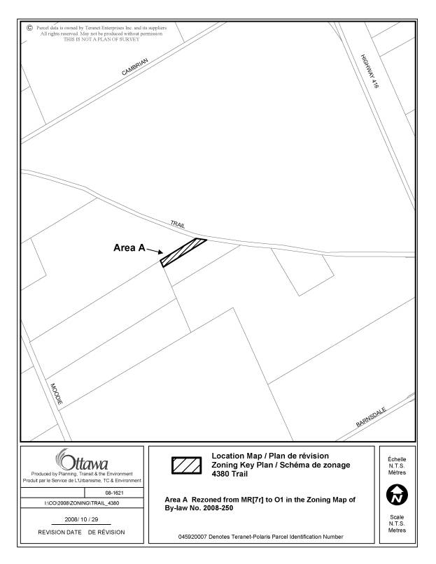
4380
Trail Road |
This
parcel is the remnant piece of a conveyance that occurred in 1967 in
violation of the severance provisions under the Planning Act for which the
owner cannot be presently found. A
certificate of validation is being sought to legalize the larger parcel that
was conveyed. In order to be able to
clearly proceed with this application, the remnant and larger parcel should
comply with zoning. By rezoning the
smaller parcel to open space, it will be in compliance as there is no minimum
lot size. At such time as a
development proposal comes forward, likely involving adjacent lands, the
remnant parcel can be rezoned. |
Change the zoning map to rezone the lands to O1 |
LANDS AFFECTED MAPS DOCUMENT
3
Location
Maps
3200
Walkley Road
3702 Prince
of Wales Drive
Sawmill
Creek, from the Rideau River to Hunt Club Road
1018
Marconi Avenue
348
Woodroffe Avenue
4101 and
5025 Innovation Drive
Part of
1941 Ogilvie Drive
15 Frank
Nighbor Place, 737 and 777 Silver Screen
8, 10, 12,
14 Nairn
260
Sunnyside Avenue
2636 Mac
Street
Mer Bleue
Road at Proposed Blackburn Bypass Extension
200
Besserer Street
Stittsville
Main Street
1491
Stittsville Main Street
2298 Midway
Avenue
Rahul
Crescent, Kochar Drive, Prince of Wales Drive
775-795
March Road
2844 Ahearn
and 2805 Carling
1645 and
1665 Russell Road
4784 and
4786 Bank and 500 White Alder
4275 and
4279 Innes Road
1324 to
2057 Old Carp Road
6139 Perth
Street
1589 John
Quinn Road
1156
Jinkinson Road
2599
Stagecoach Road
1229 Dwyer
Hill Road
5736 Bank
Street
RR6 to RR10
zones Ward 5 (5 maps)
2880 Barlow
Crescent
Part of Lot
2, Concession A, North Gower
4380 Trail
Road