|
1. BEECHWOOD
CEMETERY VIEW PROTECTION - OFFICIAL PLAN AND ZONING AMENDMENT LA
PROTECTION DES VUES DU CIMITIÈRE BEECHWOOD – MODIFICATION DU PLAN OFFICIEL ET
DU RÈGLEMENT DE ZONAGE |
Committee recommendations as
amended
(This
matter is subject to Bill 51)
That
Council:
1.
Approve the proposed changes to the Zoning By-law 2008-250 as
detailed in Document 2-10 with the exception of 222 Beechwood Avenue, which
will be considered on November 14, 2008.
2.
Approve the proposed changes to the former City of Ottawa Zoning
By-law as detailed in Document 2-10.
3.
Approve the proposed changes to the former Village of Rockcliffe
Park Zoning By-law as detailed in Document 2-10.
4. Approve the Official Plan Amendment as contained in Document
11.
Recommandations modifiÉeS du Comité
(Cette question
est assujettie au Règlement 51)
Que le Conseil :
1.
approuve les modifications proposées au
Règlement de zonage 2008-250, comme il est expliqué en détail dans les
Documents 2 à 10; sauf pour ce qui concerne la propriété située au 222,
avenue Beechwood, qui fera l’objet d’un examen le 14 novembre 2008;
2.
approuve les modifications proposées au
Règlement de zonage de l’ancienne Ville d’Ottawa, comme il est expliqué en
détail dans les Documents 2 à 10;
3.
approuve les modifications proposées au
Règlement de zonage de l’ancien Village de Rockcliffe Park, comme il est
expliqué en détail dans les Documents 2 à 10;
4. approuve la modification au
Plan officiel, telle qu’elle est exposée dans le Document 11.
Documentation
1.
Deputy
City Manager's report, Infrastructure Services and Community Sustainability,
dated 14 October 2008 (ACS2008-ICS-PLA-0216).
2. Extract of Draft Minutes, 28 October
2008.
Report to/Rapport au :
Planning and Environment
Committee
Comité de l'urbanisme et de
l'environnement
and Council / et au Conseil
14 October 2008/14 octobre 2008
Submitted by/Soumis par : Nancy
Schepers, Deputy City Manager
Directrice municipale adjointe,
Infrastructure
Services and Community Sustainability
Services
d’infrastructure et Viabilité des collectivités
Contact Person/Personne-ressource : Richard
Kilstrom, Manager/Gestionnaire, Community Planning and Design/Aménagement
et conception communautaire, Planning Branch/Direction de l’urbanisme
(613)
580-2424 x22653, Richard.Kilstrom@ottawa.ca
|
Ref N°: ACS2008-ICS-PLA-0216 |
|
SUBJECT: |
BEECHWOOD
CEMETERY VIEW PROTECTION - OFFICIAL PLAN AND ZONING |
|
|
|
|
OBJET : |
La protection des vues du cimetiÈre beechwood –plan
officiel et zonage |
REPORT RECOMMENDATION
That Planning
and Environment Committee recommend that Council:
1. Approve the proposed changes to the
Zoning By-law 2008-250 as detailed in Document 2-10.
2. Approve the proposed changes to the
former City of Ottawa Zoning By-law as detailed in Document 2-10.
3. Approve the proposed changes to the
former City of Vanier Zoning By-law as detailed in Document 2-10.
4. Approve the proposed changes to the
former Village of Rockcliffe Park Zoning By-law as detailed in Document 2-10.
5. Approve
the Official Plan Amendment as contained in Document 11.
RECOMMANDATION DU RAPPORT
Que le Comité de l'urbanisme et de l'environnement recommande au Conseil :
1. d’approuver
les modifications proposées au Règlement de zonage 2008-250, comme il est
expliqué en détail dans les Documents 2 à 10;
2. d’approuver
les modifications proposées au Règlement de zonage de l’ancienne Ville
d’Ottawa, comme il est expliqué en détail dans les Documents 2 à 10;
3. d’approuver
les modifications proposées au Règlement de zonage de l’ancienne Ville de
Vanier, comme il est expliqué en détail dans le Document 2 et indiqué dans les
Documents 2 à 10;
4. d’approuver
les modifications proposées au Règlement de zonage de l’ancien Village de
Rockcliffe Park, comme il est expliqué en détail dans les Documents 2 à 10;
4.
d’approuver la modification au Plan
officiel, telle qu’elle est exposée dans le Document 11.
EXECUTIVE SUMMARY
Assumptions and Analysis:
This report recommends approval of an Official Plan amendment that provides the policy framework for the protection of the existing views of Parliament Hill from two locations in Beechwood Cemetery – the Tommy Douglas Memorial and Poet’s Hill. It also recommends approval of the zoning changes required to ensure the views are protected.
Council directed staff to undertake this work in the staff report for the Beechwood Community Design Plan. There is a strong tradition in Ottawa for protecting the views of our national symbols like the Parliament Buildings. The first step was the preparation of a detailed and accurate 3D Model of the viewshed. All existing buildings and maximum permitted building heights were plotted onto the Model and it was determined that the maximum building height of the following properties needed to be reduced:
- 280 Beechwood Avenue (Beechwood Cemetery)
- 256 King Edward Avenue (The Shepherds of Good Hope)
- 231 Clarence Street (Condominium Corporation 664)
- 384 Wellington Street (the National Capital Commission and Public Works Canada)
For other properties, the building height was increased because it was determined that the maximum building height, as described in the Beechwood Community Design Plan, can be achieved without encroaching into the viewshed.
Financial Implications:
N/A
Public Consultation/Input:
Staff consulted with owner representatives of all the properties affected by the zoning changes. Discussions and verbal responses indicated that there are no major concerns with the proposed amendments.
RÉSUMÉ
Hypothèses et analyse :
Le présent rapport recommande d’approuver une
modification au Plan officiel qui établit le cadre stratégique de la protection
des vues sur la colline du Parlement depuis deux endroits dans
le Cimetière Beechwood, soit le monument commémoratif de Tommy Douglas et
l’Aire des poètes. Il est également recommandé d’approuver les modifications au
zonage nécessaires pour assurer la protection des vues.
Le Conseil a chargé le personnel
d’approuver ces modifications dans le rapport du personnel du Plan de
conception communautaire de Beechwood. Il existe, à Ottawa, une tradition
de longue date qui permet d’assurer la protection des vues sur les symboles
nationaux comme les édifices du Parlement. La première étape consistait à
préparer un modèle tridimensionnel détaillé et précis du panorama. Tous les
édifices existants figuraient dans le modèle, et selon la hauteur maximale
autorisée des édifices, il a été déterminé que la hauteur maximale des
propriétés suivantes devait être réduite :
- 280, avenue Beechwood (Cimetière Beechwood)
- 256,
avenue King Edward (Bergers de l’espoir)
- 231,
rue Clarence (Condominium Corporation 664)
- 384,
rue Wellington (Commission de la capitale nationale et Travaux publics et
Services gouvernementaux Canada)
La hauteur des autres édifices a été augmentée,
car il a été déterminé que la hauteur maximale autorisée (établie dans le Plan de conception communautaire de
Beechwood) est adéquate pour ces édifices car ils ne cachent pas le
panorama.
Répercussions financières :
S.O
Consultation publique / commentaires :
Le personnel a consulté les représentants des
propriétaires de l’ensemble des propriétés touchées par les modifications au
zonage. À la lumière des discussions, il semble n’y avoir aucune préoccupation
importante quant aux modifications proposées.
BACKGROUND
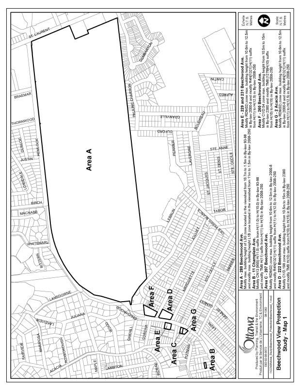
The purpose of the amendments is to establish a policy framework and zoning regulations necessary to protect the views of Parliament Hill from two points within Beechwood Cemetery – the Tommy Douglas Memorial and Poet’s Hill. Representatives of Beechwood Cemetery first presented this concept to Councillor Legendre and Councillor Bédard and to the Steering Committee established for the Beechwood Community Design Plan project in the summer of 2006. The Steering Committee and City Council agreed that there was merit in this concept and modified the Beechwood Community Design Plan so that the new provisions would not establish development guidelines that might affect the viewshed. As a result, the following recommendations were adopted by City Council on September 27, 2006:
- The Beechwood Community Design Plan “…should be amended if the view protection study for Beechwood Cemetery indicates that the properties in the Planning Area will not be able to achieve the levels of intensification as contained in the Plan.”
- The proposed building height increases at 11 Champlain Avenue, 207, 222, 229, 231 and 260 Beechwood Avenue and 2 Acacia Avenue be removed until such time as the view protection study for Beechwood Cemetery ascertains that the building height can be achieved without affecting the view to be protected.
- Direct staff to prepare an Official Plan Amendment and Zoning By-law Amendments that would result in the protection of the view of Parliament Hill from Poet’s Hill and the Tommy Douglas Memorial at Beechwood Cemetery.
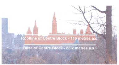
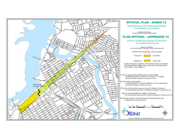
View from Poet’s Hill at Beechwood Cemetery
Existing Planning Framework for View Protection
The concept of protecting views of our national symbols has a strong tradition in Ottawa. Work started in the early 1990s by the National Capital Commission and the City of Ottawa. It culminated in the adoption of a planning framework by the former City of Ottawa and the adoption of those same policies in the Official Plan for the City of Ottawa (2003). Section 3.6.6 of the Official Plan establishes the policy framework for protecting views of Parliament Hill and other national symbols. The cornerstone policy states:
“The City will support the Central Area’s role as
the…symbolic heart of the nation by protecting the visual integrity and
symbolic primacy of the Parliament Buildings and other national symbols as seen
from Confederation Boulevard and the main approach routes to the Central Area…”
Annex 8A of the Official Plan describes the location of the key fixed viewpoints and identifies viewpoints and view sequences, maximum building heights and foreground control planes on a series of maps.
In November 2007, the National Capital Commission published “Canada’s Capital Views Protection”, a study that summarized the work done to date in partnership with the City of Ottawa, du Toit Allsopp Hillier and the Centre for Landscape Research at the University of Toronto.
DISCUSSION
Overall Approach
The overall approach to view protection is based on a model of the viewshed as prepared by the Surveys and Mapping Division of the City of Ottawa. The two viewpoints were geographically identified and a viewshed from both points was extended across the existing built fabric of the city to the base of Parliament Hill. An accurate, geographically referenced 3D Model was prepared and the maximum building heights as contained in By-law 2008-250 and in the Zoning By-laws for the former municipalities were plotted onto the Model. This information was used to determine if any existing buildings or maximum building heights encroached into the viewshed. Based on this detailed analysis, it was determined that the following properties will require downzoning:
- 280 Beechwood Avenue (Beechwood Cemetery)
- 256 King Edward Avenue (The Shepherds of Good Hope)
- 231 Clarence Street (Condominium Corporation 664)
- 384 Wellington Street (the National Capital Commission and Public Works Canada)
Staff met with owner representatives for each of the above, explained the concept and showed the extent of the downzoning.
Recommendation 1
Recommendation 1 is to approve the proposed changes
to By-law 2008-250 based on the Details of Recommended Zoning contained in
Documents 2-10. The following is a summary of the properties affected:
280 Beechwood
Avenue (Beechwood Cemetery)
The maximum building height within the affected
portion of the Cemetery lands will be reduced from 11.0 metres to 1.5 metres.
This will require that if and when Beechwood Cemetery builds new buildings and
structures, they will be required to avoid the portion of land within the
viewshed as shown in Document 3.
256 King Edward Avenue (The Shepherds of Good Hope)
The maximum building height will be reduced from
approximately 12 storeys (36.6 metres) to eight storeys (24 metres). Staff are
not concerned with this downzoning as the present owners (the Shepherds of Good
Hope) will be able to achieve their business objective of adding a fourth
storey to the existing three storey building.
231 Clarence Street (Condominium Corporation 664)
The maximum building height will be reduced from
approximately 12 storeys (36.6 metres) to eight storeys (24 metres). Staff is
not concerned with this downzoning as the likelihood of the existing owners
(Condominium Corporation 664) tearing down the existing, recently built
building and replacing it with something in the order of 12 storeys is remote.
384 Wellington Street (The National Capital Commission and Public Works
Canada)
The maximum building height will be reduced from
approximately 35 storeys (176 metres above sea level) to 12 storeys (108 meters
metres above sea level). Staff are not concerned with this change as it is not
realistic or desirable to replace the existing park, Garden of the Provinces
and the land beside it with a high rise building.
11 Champlain Avenue
The maximum building height will be increased from
approximately three and one half storeys (11 metres) to five storeys (15
metres). This is being done because it has been determined that the maximum building
height, as described in the Beechwood Community Design Plan, can be achieved
without encroaching into the viewshed.
222 Beechwood Avenue
The maximum building height will be increased from
approximately three storeys (10 metres) to five storeys (15 metres). This is
being done because it has been determined that the maximum building height, as
described in the Beechwood Community Design Plan, can be achieved without
encroaching into the viewshed.
260 Beechwood Avenue
The maximum building height will be increased from
approximately three storeys (10 metres) to five storeys (15 metres). This is
being done because it has been determined that the maximum building height, as
described in the Beechwood Community Design Plan, can be achieved without encroaching
into the viewshed.
2 Acacia Avenue
The maximum building height will be increased from
approximately three and one half storeys (11 metres) to four storeys (12.5
metres). This is being done because it has been determined that the maximum
building height, as described in the Beechwood Community Design Plan, can be
achieved without encroaching into the viewshed.
207 Beechwood Avenue
The maximum building height will be increased from
approximately three and one half storeys (11 metres) to four storeys (12.5
metres). This is being done because it has been determined that the maximum
building height, as described in the Beechwood Community Design Plan, can be
achieved without encroaching into the viewshed.
229-231 Beechwood Avenue
The maximum building height will be increased from
approximately three and one half storeys (11 metres) to four storeys (12.5
metres). This is being done because it has been determined that the maximum
building height, as described in the Beechwood Community Design Plan, can be
achieved without encroaching into the viewshed.
Recommendation 2
Recommendation 2 is to approve the proposed changes to the former
City of Ottawa Zoning By-law based on the Details of Recommended Zoning as
contained in Document 2-10. The properties affected are 280 Beechwood Avenue,
256 King Edward Avenue, 231 Clarence Street, 384 Wellington Street, 11
Champlain Avenue and the effects are identical to those mentioned in
Recommendation 1 of this section.
Recommendation 3
Recommendation 3 is to approve the proposed changes to the former
City of Vanier Zoning By-law based on the Details of Recommended Zoning
contained in Document 2-10. The properties affected are 222 and 260 Beechwood
Avenue and the effects are identical to those mentioned in Recommendation 1 of
this section.
Recommendation 4
Recommendation 4 is to approve the proposed changes to the former
Village of Rockcliffe Park Zoning By-law based on the Details of Recommended
Zoning contained in Document 2-10. The properties affected are 2 Acacia Avenue
and 207, 229 and 231 Beechwood Avenue and the effects are identical to those
mentioned in Recommendation 1 of this section.
Recommendation 5
Recommendation 5 is
to approve the Official Plan Amendment as contained in Document 11. The effect
of the amendment is to add a new Annex 12 to the Official Plan that identifies
the Viewshed Area and to add the following policy at the appropriate places in
the Official Plan:
“The City will protect the views of the
Parliament Buildings from two locations in Beechwood Cemetery. The view area,
or viewshed, and the two locations, the Tommy Douglas Memorial and Poet’s Hill,
are identified in Annex 12. A building or structure is deemed to obstruct the
view if it visually blocks the foreground view or visually mars the background
silhouette view of the Parliament Buildings.
a) For each property in the viewshed, no Zoning By-law amendment or minor variance shall be permitted that would obstruct the view
b) Site plan control approval, other regulations and City maintenance practices may also be adjusted to ensure that fences, signs, trees and other elements do not obstruct the view.”
ENVIRONMENTAL IMPLICATIONS
Adoption
of the Official Plan amendment will enhance the area for residents and visitors
to the Beechwood Cemetery and will enhance the national symbols within Ottawa.
Otherwise, there are no environmental implications resulting from these
amendments.
CONSULTATION
Staff consulted with owners or owner representatives for all the properties affected by a downzoning. Discussions and verbal responses indicated that there are no major concerns with the proposed amendments. A summary of the written comments is contained in Document 12.
FINANCIAL IMPLICATIONS
N/A
SUPPORTING DOCUMENTATION
Document 2 Details of Recommended Zoning
Document 3-10 Maps
Document 11 Official Plan Amendment
Document 12 Consultation Details
DISPOSITION
Infrastructure Services and Community Sustainability to prepare the implementing Zoning By-law and the By-law adopting the Official Plan Amendment, forward to Legal Services Branch and undertake the statutory notification.
Legal Services Branch to forward implementing By-laws to City Council.
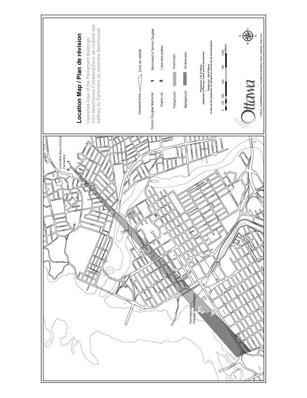
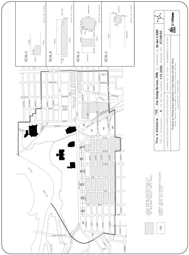
LOCATION MAP DOCUMENT 1
DETAILS OF RECOMMENDED ZONING DOCUMENT 2
Details of the Proposed Zoning Changes relating to the City of Ottawa Zoning By-law 2008‑250:
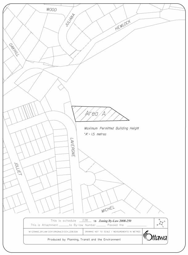
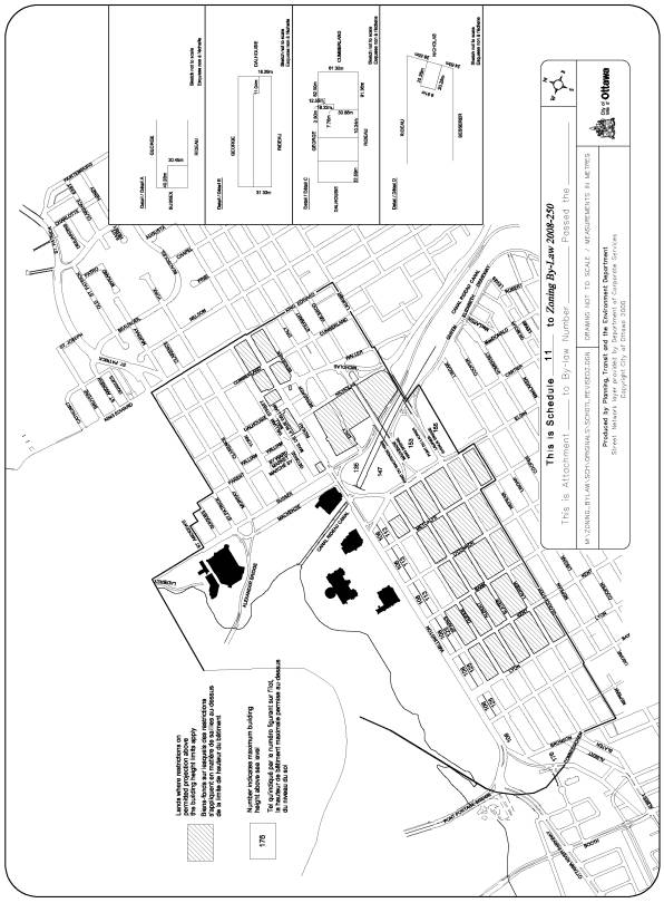
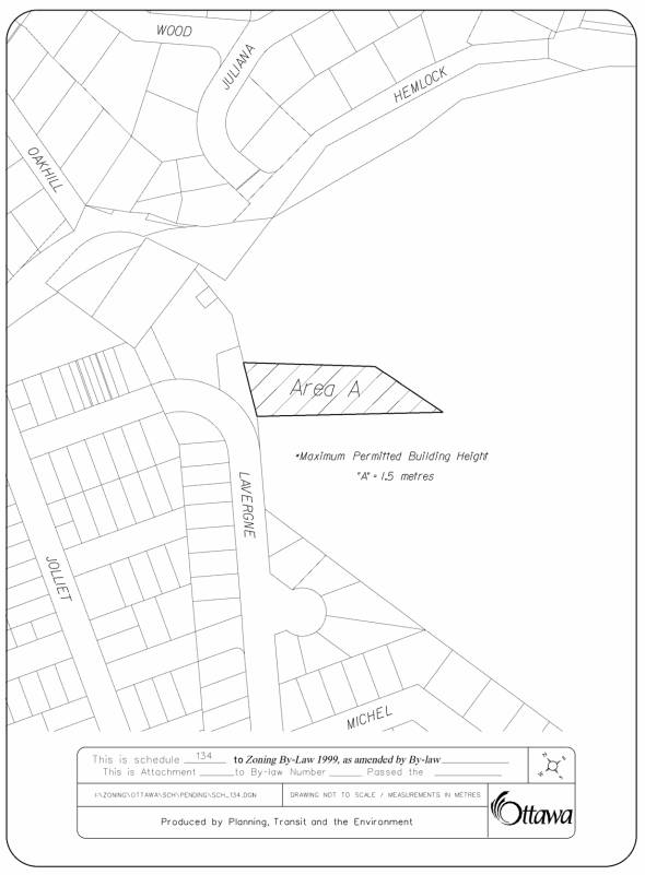
1. For part of the land known municipally as 280 Beechwood Avenue zoned L1B Community Leisure Facility Zone, the maximum building height is reduced from 11.0 m to 1.5 m for that portion of land between the Tommy Douglas Memorial/Poet’s Hill and the eastern property line contained within the Parliament Hill viewshed, as identified in Annex 13 of the Official Plan and shown as Area A on Document 3. The subject land will be rezoned from L1B to L1B S238.
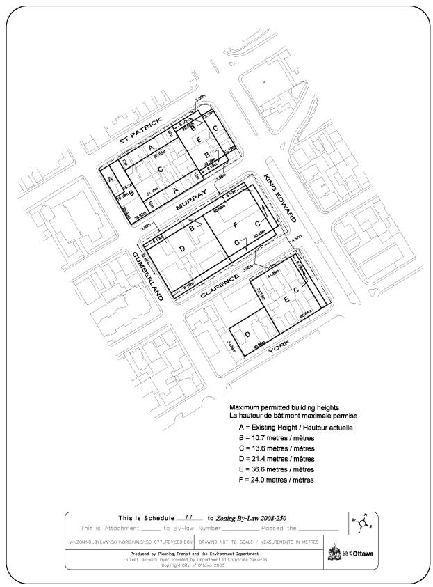
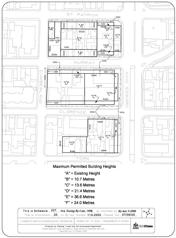
2. For the lands within the block south of Murray Street, north of Clarence Street and west of King Edward Avenue zoned R5S S77 and R5S [1667] S77, shown on Document 4, Schedule 77 is amended as follows:
(a) the said lands currently identified as area “E” will be assigned the letter “F” on the map
(b) a new line entry will be added to the list of maximum permitted building heights that states: “F” = 24.0 metres / mètres
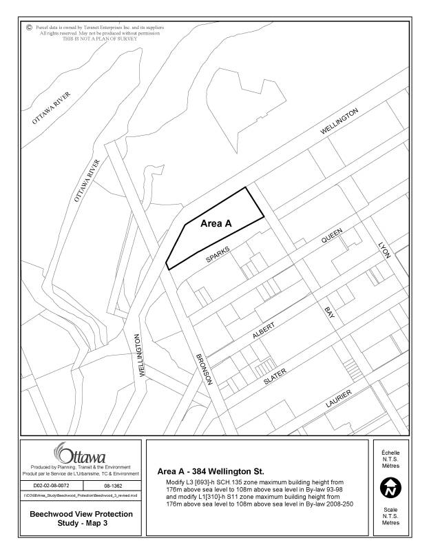
3. For the lands known municipally as 384 Wellington Street shown as Area A on Document 10 zoned L1[310]-h S11 Leisure and Open Space Zone, Schedule 11 is amended such that the maximum building height is reduced from 176 m above sea level to 108 m above sea level, shown on Document 5.
4. The land known municipally as 11 Champlain Street shown as Area B on Document 6 and zoned TM8 H(11) Traditional Mainstreet Zone, is rezoned to TM8 H(15) to reflect a maximum building height increase from 11 m to 15 m shown on Document 6.
5. The land known municipally as 222 Beechwood Avenue shown as Area D on Document 6 and zoned TM8 H(10) Traditional Mainstreet Zone, is rezoned to TM8 H(15) to reflect a maximum building height increase from 10 m to 15 m.
6. The land known municipally as 260 Beechwood Avenue shown as Area F on Document 6 and zoned TM8[1279] H(10) Traditional Mainstreet Zone, is rezoned to TM8[1279] H(15) to reflect a maximum building height increase from 10 m to 15 m.
7. The lands known municipally as 2 Acacia Avenue and 207, 229 and 231 Beechwood Avenue shown as Areas G, C and E respectively on Document 6 and zoned R4N[1321] H(11) Residential Fourth Density Zone, are rezoned to R4N[1321] H(12.5), to reflect a maximum building height increase from 11 m to 12.5 m.
Details of the Proposed Zoning Changes relating to the former City of Ottawa Zoning By‑law:
8. For part of the land known municipally as 280 Beechwood Avenue shown as Area A on Document 6 and zoned L3G Leisure and Open Space Zone, the maximum building height is reduced from 10.7 m to 1.5 m for that portion of land between the Tommy Douglas Memorial/Poet’s Hill and the eastern property line contained within the Parliament Hill viewshed, as identified in Annex 11 of the Official Plan. The subject land will be rezoned from L3G to L3G SCH 134.
9. For the lands within the block south of Murray Street, north of Clarence Street and west of King Edward Avenue and zoned R7C F(5.0) SCH 207 and R7C [1009] F(5.0) SCH 207, shown on Document 8, Schedule 207 is amended as follows:
(a) the said lands currently identified as area “E” will be assigned the letter “F” on the map
(b) a new line entry will be added to the list of maximum permitted building heights that states: “F” = 24.0 Metres
10. For the lands known municipally as 384 Wellington Street shown as Area A on Document 10 zoned L3 [693]-h Sch.135 Leisure and Open Space Zone; Schedule 135 is amended such that the maximum building height is reduced from 176 m above sea level to 108 m above sea level, as shown on Document 9.
11. The land known municipally as 11 Champlain Street zoned CN13 [955] H(11.0) Neighbourhood Commercial Zone, is rezoned to CN13 [955] H(15) to reflect a maximum building height increase from 11 m to 15 m as shown on Document 6.
Details of the Proposed Zoning Changes relating to the former City of Vanier Zoning By‑law:
12. For the land known municipally as 222 Beechwood Avenue and zoned C1/D.198 District Commercial Zone, and the land known municipally as 260 Beechwood Avenue and zoned C1/D.54 District Commercial Zone, clause 16.2(i) is amended to by deleting the words “but excluding 222 and 260 Beechwood Avenue” so that the maximum building height is 15 metres as shown as Areas D and F on Document 6.
Details of
the Proposed Zoning Changes relating to the former Village of Rockcliffe Park
Zoning By-law:
13. For the lands known municipally as 2 Acacia Avenue and 207, 229 and 231 Beechwood Avenue shown as Areas G, C and E respectively on Document 6 and zoned RD9(02) Residential Multiple Family Zone, subclause 6.9.4.2 is amended by deleting the words “except for 2 Acacia Street and 207, 229 and 231 Beechwood Avenue”.
DOCUMENT 3
DOCUMENT 4
DOCUMENT 5
DOCUMENT 6
DOCUMENT 7
DOCUMENT 8
DOCUMENT 9
DOCUMENT 10
OFFICIAL PLAN AMENDMENT DOCUMENT 11
Official
Plan Amendment **Insert Amendment # here
to the Official Plan for the City of Ottawa
Index
|
|
|
|
|
|
||
|
|
|
|
|
|
||
|
|
|
|
|
|
|
|
|
|
|
|
|
|
|
|
|
|
||
|
|
|
|
|
|
|
|
|
|
|
|
|
|
|
|
|
|
|
|
|
|
||
The Statement of Components
Part A – The Preamble, introduces the actual Amendment but does not constitute part of the Amendment No. **Enter Amendment # here to the Official Plan for the City of Ottawa.
Part B – The Amendment, consisting of the following text and schedules constitutes the actual Amendment No. **Enter Amendment # here to the Official Plan for the City of Ottawa.
Part C – The Appendices, does not form part of the Amendment but is provided to clarify the intent and to supply background information related to the Amendment.
Part A – The Preamble
1.0 Purpose
The purpose of this amendment is to establish a policy framework designed to protect the views of Parliament Hill from two locations in Canada’s National Military Cemetery - Beechwood Cemetery. The two locations are the Tommy Douglas Memorial and Poets Hill. The policy framework will lead to the establishment of land use and other regulatory provisions that prohibit the encroachment of buildings and/or other structures into the viewshed.
2.0 Location
This amendment applies to the land between Beechwood Cemetery and Parliament Hill, contained in the viewshed as shown in Figure 1, and includes land:
·
In Vanier, Rockcliffe Park and New Edinburgh near Beechwood
Avenue
- On the southern portion of Porter Island
- Around the intersection of St. Patrick Street and Cobourg Street
- Between the above mentioned intersection and King Edward Avenue near Murray Street and St. Patrick Street
- Between King Edward Avenue and the Rideau Canal including those lands in the By Ward Market abutting St. Patrick Street, Murray Street, Clarence Street and York Street,
- On Parliament Hill, and
- In the Parliamentary Precinct, west of Parliament Hill, up to the Ottawa River Parkway and the intersection of Bronson Avenue and Sparks Street.
3.0 Basis
This Amendment is consistent with the Strategic
Direction contained in Section 2 of the Official Plan, which “supports the
overall image of Ottawa as the Nation’s capital” and which contributes to the
creation of “attractive public spaces
and important vistas”.
The Amendment is also consistent with the land use policies in Section 3.6.6 of the Official Plan which supports “…protecting the visual integrity and symbolic primacy of the Parliament Buildings and other national symbols…and that buildings constructed in the area…do not visually mar the silhouette of the Parliament Buildings and do not visually dominate the Parliament Buildings and other national symbols.” It is also consistent with the provisions of the Central Area Secondary Plan, which contain provisions on view protection and building height.
Part B – The Amendment
1.0 Introduction
All of this part of this document, entitled Part B – The Amendment consisting of the following text and the attached Schedule 1 constitutes Amendment No. to the Official Plan.
2.0 Details of Amendment
The following changes are hereby made to the
Official Plan:
2.1
Add the following phrase after 8D in the first introductory sentence in
Section 7 Annexes in Volume 1:
“…and Annex 12,…”,
And renumber Annex 12 as Annex 13 at the end of the Annex list and add the following before Annex 13: Annex 12 Viewshed Area of the Parliament Buildings from Beechwood Cemetery
2.2 Add the following provisions at three locations in Volume 1: City of Ottawa Official Plan:
· At the end of the policy section under 3.6.1 – General Urban Area as policy 11
· At the end of the policy section under 3.6.3 – Mainstreets as policy 14, and
· At the end of the policy section under 3.6.6 – Central Area as policy 10:
“The City will protect the views of the Parliament Buildings from two locations in Beechwood Cemetery. The view area, or viewshed, and the two locations, the Tommy Douglas Memorial and Poet’s Hill, are identified in Annex 12. A building or structure is deemed to obstruct the view if it visually blocks the foreground view or visually mars the background silhouette view of the Parliament Buildings.
c) For each property in the viewshed, no zoning by-law amendment or minor variance shall be permitted that would obstruct the view
d) Site plan control approval, other regulations and City maintenance practices may also be adjusted to ensure that fences, signs, trees and other elements do not obstruct the view.”
2.3 Add Schedule 1 attached as Annex 12 in Section 7 in Volume 1 and rename the existing Annex 12 – Official Plan Amendments as Annex 13.
2.4 Add the following provision at six locations in Volume 2A: Secondary Plans:
·
At the end of section 1.4.3 i) View from Downtown Streets in
the former City of Ottawa Official Plan – Central Area, Parliamentary Precinct,
·
At the end of section 1.5.3 n) Views in the former City of
Ottawa Official Plan – Central Area, By Ward Market,
·
At the end of section 1.7.3 g) Vantage Points in the former
City of Ottawa Official Plan – Central Area, The Canal,
·
At the end of section 1.8.3 k) Views in the former City of
Ottawa Official Plan – Central Area, Lowertown,
·
At the end of section 1.10.3 f) Views in the former City of
Ottawa Official Plan – Central Area, Upper Town,
·
At the end of section 1.13.3 m) View in the former City of
Ottawa Official Plan – Central Area, Sparks Street:
“City Council shall protect the views of the Parliament Buildings from two locations at Beechwood Cemetery, as identified in Annex 12 in Volume 1 of this Plan.”
3.0 Implementation and Interpretation
Implementation and interpretation of this Amendment shall be in accordance with the policies of the City of Ottawa Official Plan.
CONSULTATION DETAILS DOCUMENT 12
The Official Plan Amendment and the proposed list of zoning changes were included in the public and technical circulations. The notice of the applications was included in the advertisement, which appeared in the Citizen and Le Droit on October 17, 2008. In response to the public and technical circulation of the Official Plan and Zoning By-law Amendment in July 2008, the following comments were received.
11 Champlain
Avenue
For 11 Champlain Avenue, the “existing residential uses” should be included in the zoning in accordance with the planning report for the Beechwood Community Design Plan (May 18, 2006).
Staff Response
The zoning has been checked and it is confirmed that the existing use (a 4-unit apartment) is a permitted use in the TM8 Zone so no changes are required.
National Capital Commission (NCC).
“The NCC does support the principle of extending the protection of important viewsheds to the key National Symbols from outside of the core area. In order to be consistent with the methodology used in other existing Views Protection, we wish to make some recommendations for the final amendments. We commend the City’s planning staff for initiating this OP amendment to further protect the views of National Symbols and the Parliamentary silhouette from locations in the City outside of the central area. Beechwood Cemetery itself also has National Significance and the identification of a link between the Cemetery and Parliament is proactive and confirms the positive long term civic vision to preserve this valuable symbol.
1. We suggest the final amendments be more precise as to the actual view to be protected from the two (2) points at the cemetery; and perhaps identifying a tangible view point or series of views (for example, is it just the area above the eaves line, all the view between the Library of Parliament and the East Block, just the Peace Tower?). It is appropriate to also note the benchmark elevation/ coordinates representing points 1 and 2 on draft OP annex 11.
2. The proposed OP Annex 11 notes the foreground and background area in the viewshed cone. The areas of Parliament Hill, the Federal Judicial Precinct and the specific federal properties identified in the Beechwood Viewpoint study are already protected, because they are either subject to a lower height restriction than the recommended maximum height controls needed for the protection of the National Symbols and/or they are in the Central Capital landscape area of foreground controls in the existing central area views protected by the Views Study and the existing OP Annex 8A provisions. These portions of the Parliamentary Precinct are well governed with respect to height limits for the protection of views in both the previously noted federal plans and the OP. We suggest that it may be suitable to consider re-labelling the proposed Annex 11 legend to replace “background control” with “Area under regulation of Parliamentary Precinct and Ottawa Views Study”.
3. Given a review of the model, we can support the principle that the municipal zoning provisions may be suitable for a reduction from the permitted 176 masl to the proposed 108masl for the NCC site at 84 Bronson. However, the model limits seem to exclude the entire 84 Bronson site.
4. As noted above, 384 Wellington is owned by PWGSC. We reiterate our position that in this instance, formal comments should be sought directly from our federal partner on these applications.”
Staff
Response