1. STREET CLOSURE –
ROAD ALLOWANCE, CONCESSION 4, BETWEEN LOTS 10 AND 11, TORBOLTON, FORMER
TOWNSHIP OF WEST CARLETON FERMETURE
DE RUE – EMPRISE ROUTIERE, CONCESSION 4, ENTRE LES LOTS 10 ET 11, RUE
TORBOLTON, ANCIEN CANTON DE WEST CARLETON |
Committee recommendation as amended
That Council confirm the status of the above-noted land as an unopened
road allowance.
Recommandation MODIFIÉE du Comité
Que le Conseil confirme la
désignation du terrain susmentionné d’emprise routière non ouverte.
Documentation
1.
Deputy
City Manager's report Planning, Transit
and the Environment dated 11 August 2008 (ACS2008-PTE-PLA-0173).
2.
Extract
of Draft Minutes, 11 September 2008.
Report
to/Rapport au:
Agriculture and Rural Affairs Committee
Comité d'agriculture et des questions rurales
and Council / et au Conseil
11 August 2008 / le 11 aôut 2008
Submitted by/Soumis par : Nancy Schepers, Deputy City Manager/
Directrice municipale adjointe,
Planning, Transit and the Environment/Urbanisme,
Transport en commun et Environnement
Contact
Person/Personne-ressource : Grant Lindsay, Manager/Gestionnaire,
Development Approvals/Approbation des demandes d'aménagement
(613)
580-2424, 13242 Grant.Lindsay@ottawa.ca
REPORT RECOMMENDATION
That the Agriculture and Rural
Affairs Committee recommend Council approve a Street Closure application for
the lands legally known as Concession 4, Part of Lots 10 and 11, Torbolton,
Former Township of West Carleton, as shown in Document 1.
RECOMMANDATION DU RAPPORT
Que le Comité de l'agriculture et des affaires
rurales recommande au Conseil d’approuver la demande de fermeture de rue pour
les terrains connus comme la concession 4, qui fait partie des lots 10 et 11,
rue Torbolton, dans l’ancien Canton de West Carleton, comme le montre le
document 1.
BACKGROUND
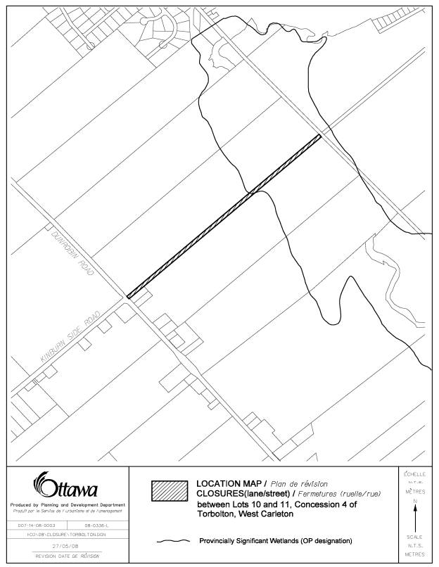
The subject site is a legally open and untravelled road allowance between Lots 10 and 11, Concession 4, Torbolton. The untravelled road allowance abuts municipal address 3796 Dunrobin Road to the south, in the hamlet of Woodlawn. Furthermore, this road allowance begins at the intersection of Kinburn Side Road and Dunrobin Road, and extends approximately 1.5 kilometres northeast to the next intersecting untravelled road allowance in Concession 5 (see Document 1).
The applicant, and owner of 3796 Dunrobin Road, proposes closing the subject road allowance for the purpose of purchasing all or a portion of this land such that the existing gas bar at 3796 Dunrobin Road can be redeveloped.
Staff, through a Delegated Authority Report, approved the initial Street Closure application on April 25, 2008. During the subsequent 20-day ‘notice of approval’ period objections were received from both a local resident and Councillor Eli El-Chantiry. City Council approved procedures for Street Closure applications require a report be brought forward, by staff, to either the Planning and Environment Committee or the Agriculture and Rural Affairs Committee when objections are made to the staff decision.
DISCUSSION
Official Plan Policies
The Official Plan does not designate this road allowance as either a proposed or conceptual public road within Schedule G (Rural Road Network). A portion of the subject road allowance dissects a Significant Wetland Designation within the Official Plan, and due to the restrictive development policies within this designation the likelihood of utilizing the land as a future road is negligible.
Utilities, Access, and Transit
There are no utility installations identified within the subject lands, therefore from a utility perspective no issues exist with closing the subject road allowance.
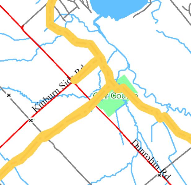
No formal accesses are impacted by the closure of this untravelled road allowance. The gas bar located at 3976 Dunrobin Road currently utilizes the road allowance as a secondary access but does not depend on this access for formal entry into the site (see Document 2).
The West Carleton Snowmobile Trails Association Inc. (WCSTA) has identified a snowmobile trail on the subject lands linking into their network of trails within West Carleton (see Document 3). Despite this identified trail, no legally binding agreement has been established between the City and the WCSTA to utilize the City-owned road allowance as a snowmobile trail. The closure of the road allowance and possible sale does not prevent the WCSTA from seeking an agreement with the City or any future landowner.
The untravelled road allowance has been utilized in the past as a rural transit stop, as part of the Rural Partners Transit Service. Transport Thom provided a service from Woodlawn (specifically Nicholl’s Store) on Route 501 of OC Transpo’s Rural Transit Service. This service, however, has been discontinued.
Conclusion
The subject street closure will not adversely impact future rural transportation options, specifically for the use of a transit stop, and for the protection of an identified future road. The open, untravelled road allowance, if closed and sold, can retain options on title to have a local transit stop situated on site, if desired by Council. Furthermore, this road allowance has not been identified in the City’s Official Plan (Schedule G) as being a long-term potential or planned transportation corridor, thus there is no need to protect it for future use.
CONSULTATION
Notice of this application was carried out in accordance with the City's Public Notification and Consultation Policy. The Ward Councillor objects to staff’s recommendation.
Public notification was not a requirement, however comments were received from the public during the notification of closing period and are contained in Document 4.
APPLICATION PROCESS TIMELINE STATUS
This application was not processed by the "On Time Decision Date" established for the processing of Street/Lane Closure applications. The application has been objected to, thus requiring it to be brought before the Agriculture and Rural Affairs Committee meeting.
SUPPORTING DOCUMENTATION
Document 1 Location Map
Document 2 Access (Air Photo)
Document 3 WCSTA Snowmobile Trail
Document 4 Consultation Details
DISPOSITION
City Clerk’s Branch, Council and Committee Services to notify the owner, Dave Sellers, 119 Langstaff Drive, Carp, ON, K1P 6L8, Program Manager, Assessment, Financial Services Branch (Mail Code: 26-76) of City Council’s decision.
Planning, Transit and the Environment Department to prepare the implementing by-law, forward to Legal Services Branch and undertake the statutory notification.
Legal Services Branch to forward the implementing by-law to City Council.
LOCATION MAP DOCUMENT
1
ACCESS (AIR PHOTO) DOCUMENT 2
WCSTA SNOWMOBILE TRAIL DOCUMENT
3
![]() Snowmobile
Trail
Snowmobile
Trail
CONSULTATION DETAILS DOCUMENT 4
NOTIFICATION AND CONSULTATION PROCESS
Notification and public consultation was undertaken in accordance with the Public Notification and Public Consultation Policy approved by City Council.
PUBLIC COMMENTS
An adjacent resident expressed his objection to the road closure due to the negative implications it will have on the surrounding community, and on any future developments the area may experience.
COUNCILLORS COMMENTS
The Councillor has objected to the subject application on the basis that the open, untravelled road allowance is utilized as a carpool parking lot, a local snowmobile route and has been used in the past as a Rural Transit Service stop (Route 501). The closure and sale of this City owned property would compromise the use of the carpool lot, the snowmobile route and future use of a local transit service, and should remain in City ownership.
RESPONSE
In regards to the carpool parking lot, the Transportation Master Plan does not identify the subject location as a formal carpool parking lot. Those identified include:
Hwy 7 at Cemetery Road, near Carleton Place
Hwy 7 and Dwyer Hill Road
Hwy 17 at Kinburn Side Road
Hwy 417 at Panmure Road
Ottawa Road 49 and Ottawa Road 3, Dwyer Hill
Hwy 416 at Bankfield Road (Ottawa Road 8)
Hwy 416 at Rideau River Road (Ottawa Road 19)
Hwy 417 at Ottawa Road 5, near Limoges
The closure of this road
allowance does not inhibit public access, but only declassifies this portion of
land as a road right of way. In the
event that the street is closed, the land will remain under the ownership of
the City. If the City decides to sell
the land, the Real Property Asset Management Branch (RPAM) will initiate a property
disposal circulation to City Departments, the Ward Councillor, affected
agencies, and abutting owners. As part of the property disposal circulation
process, staff will consider and comment on the merit of retaining the property
or a section of it for creating a formal carpool parking lot, under the
direction of the Ward Councillor and City Council.
If there are no comments on RPAM’s circulation the applicant of the
Street Closing application will be given the opportunity to purchase the closed
street, at a price to be determined by City Council (usually market
value).