5. ZONING - 416, 418 AND PART OF 424 RICHMOND ROAD, PART
OF 579 BYRON AVENUE AND 414 ROOSEVELT AVENUE ZONAGE
- 416, 418 ET PARTIE DU 424, CHEMIN RICHMOND, PARTIE DU 579, AVENUE BYRON ET
414, AVENUE ROOSEVELT |
Committee recommendationS AS
AMENDED
(This application
is subject to Bill 51)
That
Council:
1. Approve
an amendment to the Zoning By-law 2008-250, to change the zoning of 416, 418
and Part of 424 Richmond Road, Part of 579 Byron Avenue and 414 Roosevelt
Avenue from Traditional Mainstreet TM and TM[83] to a new Traditional
Mainstreet TM zone as shown in Document 1 and detailed in Documents 3 and 4.
2. Approve
an amendment to the former City of Ottawa Zoning By-law, to change the zoning
of 416, 418 and part of 424 Richmond Road, Part of 579 Byron Avenue and 414
Roosevelt Avenue from Neighbourhood Commercial CNF(2.0), CN[848]F(2.0),
CN[498]F(2.0) and Leisure L2 to a new Neighbourhood Commercial CN exception
Zone as shown in Document 2 and as detailed in Documents 3 and 4.
3. That the strip of parkland currently
designated and dedicated by by-law that is located along the north side of
Byron Avenue between Golden Avenue and Roosevelt Avenue be declared potentially
surplus as park and removed from the City’s park inventory and formally
dedicated by by-law as part of the Byron Avenue right-of-way and that the
Department of Planning, Transit and the Environment undertake the formal public
consultation as required by the Former City of Ottawa policy regarding
City-owned parkland and report back to Committee and Council with
recommendations related to removing the parkland dedication applicable to the
subject property and re-dedicated as part of the Byron Avenue
right of way.
4. That
an interim License of Occupation be granted to the owner of the property,
subject to the standard administration fee, to allow the owner to have legal
access to the subject property from Byron Avenue in order that a building
permit can be issued for Phase One, which interim License of Occupation shall
be in effect until such time as Council gives formal approval to having the
subject strip of parkland re-dedicated as part of the Byron Avenue right of
way, failing which the Owner shall secure a permanent easement at market value
in accordance with the Agreement of Purchase and Sale dated 16 June 2008
previously provided to the owner.
RecommandationS modifiÉeS du Comité
(Cette
demande est assujettie au Règlement 51)
Que le Conseil :
1. approuve une modification au Règlement
de zonage 2008-250 visant à remplacer la désignation de zonage du 416, du 418
et d’une partie du 424, chemin Richmond, d’une partie du 579, avenue Byron et
du 414, avenue Roosevelt, soit Zone de rue principale traditionnelle (TM et
TM[83]), par une nouvelle zone de rue principale traditionnelle (TM), comme
l’illustre le document 1 et le précisent les documents 3 et 4.
2. approuve une modification au Règlement de zonage de
l’ancienne Ville d’Ottawa visant à remplacer la désignation de zonage du 416,
du 418 et d’une partie du 424, chemin Richmond, d’une partie du 579, avenue
Byron et du 414, avenue Roosevelt, soit Zone commerciale de quartier (CNF(2.0),
CN[848]F(2.0), CN[498]F(2.0)) et Zone de loisirs (L2), par une Zone d’exception
à une zone commerciale de quartier, comme l’illustre le document 2 et le précisent
les documents 3 et 4.
3. que
la lisière située du côté nord de l’avenue Byron entre les avenues Golden et
Roosevelt, qui est actuellement désignée comme un terrain à vocation de parc
aux termes d’un règlement municipal, soit déclarée potentiellement excédentaire
en tant que parc, retirée de l’inventaire des parcs de la Ville et
officiellement désignée en vertu d’un règlement municipal comme une partie de
l’emprise de l’avenue Byron; et que le Service de l’urbanisme, du transport en
commun et de l’environnement mène une consultation publique officielle, comme
l’exige la politique de l’ancienne Ville d’Ottawa concernant les terrains à
vocation de parc appartenant à la Ville, et soumette au Comité et au Conseil un
rapport assorti de recommandations sur la suppression de la désignation de parc
s’appliquant à la propriété en cause et sa nouvelle désignation comme une
partie de l’emprise de l’avenue Byron.
4. qu’une
licence d’occupation provisoire soit accordée au propriétaire du terrain, sous
réserve des frais d’administration courants, afin de lui permettre d’avoir
légalement accès au terrain à partir de l’avenue Byron, de façon qu’un permis
de construire puisse être délivré pour la réalisation de la phase 1; cette
licence d’occupation demeurera en vigueur jusqu’à ce que le Conseil approuve
officiellement le changement de désignation de la lisière de terrain en cause
et son inclusion dans l’emprise routière de l’avenue Byron, à défaut de quoi le
propriétaire devra acquérir une servitude permanente au prix du marché
conformément à la convention d’achat datée du 16 juin 2008 qu’il a déjà
produite.
Documentation
1.
Deputy
City Manager, Planning, Transit and the Environment report dated 1 August 2008
(ACS2008-PTE-PLA-0168).
2. Extract of Draft Minutes, 18 August 2008.
Report to/Rapport au:
Planning
and Environment Committee
Comité de l'urbanisme et de
l'environnement
and Council / et au Conseil
1 August 2008 / le 1 août 2008
Submitted by/Soumis par : Nancy
Schepers, Deputy City Manager
Directrice municipale adjointe
Planning, Transit and the Environment
Urbanisme, Transport en commun et Environnement
Contact Person/Personne Ressource : Grant Lindsay,
Manager/Gestionnaire, Development Approvals/Approbation des demandes
d'aménagement,
Planning Branch/Direction de
l’urbanisme
(613)
580-2424, 13242 Grant.Lindsay@ottawa.ca
REPORT RECOMMENDATIONS
That the Planning and Environment Committee recommend
Council:
1. Approve
an amendment to the Zoning By-law 2008-250, to change the zoning of 416, 418
and Part of 424 Richmond Road, Part of 579 Byron Avenue and 414 Roosevelt
Avenue from Traditional Mainstreet TM and TM[83] to a new Traditional
Mainstreet TM zone as shown in Document 1 and detailed in Documents 3 and 4.
2. Approve an amendment to the former City
of Ottawa Zoning By-law, to change the zoning of 416, 418 and part of 424
Richmond Road, Part of 579 Byron Avenue and 414 Roosevelt Avenue from
Neighbourhood Commercial CNF(2.0), CN[848]F(2.0), CN[498]F(2.0) and Leisure L2
to a new Neighbourhood Commercial CN exception Zone as shown in Document 2 and
as detailed in Documents 3 and 4.
RECOMMANDATIONS DU RAPPORT
Que le Comité de recommande au Conseil :
1. d’approuver
une modification au Règlement de zonage 2008-250 visant à remplacer la
désignation de zonage du 416, du 418 et d’une partie du 424, chemin Richmond,
d’une partie du 579, avenue Byron et du 414, avenue Roosevelt, soit Zone de rue
principale traditionnelle (TM et TM[83]), par une nouvelle zone de rue
principale traditionnelle (TM), comme l’illustre le document 1 et le précisent
les documents 3 et 4.
2.
d’approuver une modification au
Règlement de zonage de l’ancienne Ville d’Ottawa visant à remplacer la
désignation de zonage du 416, du 418 et d’une partie du 424, chemin Richmond,
d’une partie du 579, avenue Byron et du 414, avenue Roosevelt, soit Zone
commerciale de quartier (CNF(2.0), CN[848]F(2.0), CN[498]F(2.0)) et Zone de
loisirs (L2), par une Zone d’exception à une zone commerciale de quartier,
comme l’illustre le document 2 et le précisent les documents 3 et 4.
BACKGROUND
The subject property is located in the block of land bounded by Richmond Road, Roosevelt Avenue, Byron Avenue and Golden Avenue. The applicant owns the entire block and has recently received Site Plan Control approval to construct a new 31-metre high (10-storey) building on approximately the western 25 percent of the lands. This new development will be mixed-use, with commercial uses on the ground floor and residential above. There will be two levels of underground parking and access to the underground parking garage will be provided from Byron Avenue.
This rezoning application relates to the remainder (approximately 75 percent) of the property. The majority of this land is presently occupied with low-rise (one to four storey) commercial buildings with surface parking. The applicant is proposing to rezone this portion of the block to allow another mixed-use building having a height of 28 metres (eight storeys) with commercial uses on the ground floor and residential above. Two levels of underground parking are also proposed with approximately 60 spaces being provided for public parking. Vehicular access will be provided from Byron Avenue and shared with the building approved on the other portion of the site.
Existing Zoning/Proposed Zoning
The zoning under the Zoning By-law
2008-250 is a Traditional Mainstreet zoning while the zoning of the former City
of Ottawa Zoning By-law is Neighbourhood Commercial (CN) and Leisure (L2). Both the Neighbourhood Commercial (CN) and
the Traditional Mainstreet (TM) zones allow the uses proposed, however, the
Department is recommending changes to specific performance standards, to allow
the proposed development. In relation
to the Comprehensive Zoning By-law, the proposed changes include:
- Changes
in the yard setback provisions and the height provisions to correspond to the
Schedule contained in Document 4;
- A
reduction in the number of commercial parking spaces provided from 81 to 78.
- Exception
83, which allows automotive uses, no longer applies to the subject property.
In relation to the former City of Ottawa
Zoning By-law the proposed modifications to the performance standards include:
- A
reduction in the number of loading spaces from three to two;
- A
reduction in the number of commercial parking spaces required from 94 to 78.
- To
allow the commercial parking spaces provided to be made available for use by
any other land use located either on or off site.
- Increase
in Floor Space Index from 2.0 to 2.5.
- Changes
in the yard setback provisions and the height provisions to correspond to the
Schedule contained in Document 4;
In addition to these performance standard revisions, the applicant is also proposing to close and purchase an excess and untravelled portion of the City's Road Allowance at the corner of Byron and Roosevelt Avenues. This portion of Road Allowance is currently zoned Leisure (L2) in the former City of Ottawa Zoning By-law. These lands are proposed to be rezoned to Neighbourhood Commercial (CN[XX] F(2.5)). This rezoning is not required in the Zoning By‑law 2008-250.
RECOMMENDATIONS
1 AND 2
DISCUSSION
Official Plan
The Official Plan designates the subject property as Traditional Mainstreet. Lands with this designation offer some of the most significant opportunities in the city for intensification through more compact forms of development, a lively mix of uses and a pedestrian-friendly environment. The Official Plan encourages intensification along Mainstreets primarily through the redevelopment of sites and additions to buildings. The most common feature of all Mainstreets is their function as a mixed-use corridor with their ability to provide a wide range of goods and services for neighbouring communities and beyond. Development along Mainstreets is intended to increase support to the public transit system, to enhance a community focus and to minimize travel and disruption to existing neighbourhoods. Redevelopment and infill are encouraged on Traditional and Arterial Mainstreets in order to optimize the use of land through increased building height and density. The Official Plan supports building heights in a range of four to six storeys along Traditional Mainstreets with greater heights being considered if a proposal meets any one of five certain criteria. These are:
1. Where larger building heights are established through a Community Design Plan.
2. Where proposed heights conform with prevailing building heights or provides a transition between existing buildings.
3. Where a development fosters the creation of a community focus where the proposal is on a corner lot or a gateway location or at a location where there are opportunities to support transit at a transit stop or station.
4. Where a development incorporates facilities, services that in the opinion of the City advances the vision of Mainstreets.
5. Where the application of the provisions of the compatibility policies of the Official Plan determine that additional height is appropriate.
In considering the applicant's request for an increase in height, the Department notes that while only having to satisfy one of any five criteria related to height increase, the proposal satisfies all but one. In this regard, the proposed height of 28 metres provides an excellent transition between the 35-metre height limit of the Exchange building on the north side of Richmond Road, opposite Phase I, the 31-metre height of the building contained in Phase I of the redevelopment of this block and the 24 metre height limit allowed by both the former and current Zoning By law in the block immediately to the east of the property, on both the north and south side of Richmond Road.
Phase I of the development of this block and the proposed development are located on a block of land at the western edge of Westboro Village, and represents a gateway location to this area. The proposed zoning will help define the entrance and boundary to the neighbourhood along Richmond Road, from the lands to the west. It will also complement the nine-storey Exchange building on the north side of Richmond Road and the 10-storey Phase I development for this site. As well, the subject property is a corner lot, having access on three streets and there is a transit stop along the Richmond Road frontage of the lands, with a transit station located approximately 400 metres to the north.
The proposed Zoning By-law amendment will allow commercial uses at grade, with a larger setback from Richmond Road, with a large patio area between the proposed development and Phase I. These commercial uses, a wider sidewalk and patio area will enhance the pedestrian friendly atmosphere of this neighbourhood and increase the animation at ground level. In particular, the outdoor patio area will create a public space for interaction amongst people who live, work or are visiting the area.
Finally, the proposed development satisfies the Official Plan compatibility policies in Sections 2.5.1. and 4.11. In this regard, Section 2.5.1. indicates that development should be designed in a manner that connects public to private space. The physical environment should be enlivened and complemented by new development. As indicated above, the new building, with commercial uses on the ground floor, a wider sidewalk and the proposed patio area, will help create a development that satisfies these policies.
With respect to Section 4.11, it is recognized that when accessing the relationship between existing and new development and the appropriateness of new development, prominent considerations include such things as noise, light spill over, parking, vehicular access, shadowing, height, bulk or mass, the relationship of a building's scale to the street, the distance between buildings and micro-climate conditions. The Plan indicates that often, to address these issues and arrive at a compatibility of scale and use, a careful design response will be required. While all of these issues are important considerations in reviewing a Site Plan Control application, issues related to vehicular parking, sun shadowing, height, bulk, building proximity, building scale and micro climate also need to be addressed at the Zoning By-law amendment stage to achieve that design response.
With regard to building height, the Official Plan indicates that new buildings should have regard to the area context, being the massing and height of existing buildings and the planned function of the area. This is similar to the policies in the Official Plan relating to Traditional Mainstreets and as mentioned above, the proposed building is immediately east of an approved 31-metre high building and opposite a building (the Exchange) with an approved height of 35 metres. As well, the planned function of the properties to the east is, through the zoning approved by City Council, to allow a building having a height of 24 metres. It is the Department's position that the proposed height of 28 metres is compatible with the height of existing buildings and buildings anticipated by the current zoning.
In relation to the bulk and massing, the applicant is proposing a building that has an increasing terraced setback along Richmond Road, as the building gets higher. This terraced setback decreases the massing and bulk of the building as well as any detrimental effect the building would have on the streetscape. It enhances the sense of human scale and thus eliminates an overpowering building presence along the street edge that can result from massing. It should be noted that the zoning of other lands along Richmond Road, with height limits of 24, 31 and 35 metres, do not require terraced setbacks as proposed by the applicant for this proposal.
In addition to terracing the setback of the building to decrease the impact of massing and bulk, the applicant is also proposing a landscaped public plaza along Richmond Road and a separation distance of approximately 8.0 metres between Phase I and Phase II. The plaza and separation distance will emphasize that the development of the block is two separate buildings and provides a desirable pedestrian walkway linking the community to the south with Richmond Road.
With respect to traffic, the proposed development is anticipated to generate 38 new vehicle trips during the AM peak and 48 trips during the PM peak. These “New Trips” are expected to be distributed along the adjacent roads, such as Richmond Road and Byron Avenue. The traffic study submitted in support of this zoning application has examined the operation of nearby intersections, namely Byron/Golden, Byron/Roosevelt, Richmond/Golden, Richmond/Roosevelt, and Byron/Churchill. The analysis has determined that all intersections would continue to operate at a good level of service following the development of Phase II of the site.
In relation to the proposed reduction in commercial parking by three parking spaces from the requirement of the Zoning By-law 2008-250, site checks conducted at the peak times indicate that there is adequate on-street capacity to accommodate the reduction. As well, it is anticipated that many clients who will travel to the proposed commercial uses on the ground floor of the building will live in the area and will have the opportunity to use forms of transportation other than a private vehicle.
A Sun Shadow Study completed for the proposed development indicates that buildings to the north will be slightly affected by the proposed development in winter months while the building adjacent to the east is expected to be impacted only late in the day, with the greatest impact being in the winter months. The proposed building proximity to the property line along Richmond Road and terracing of the building will mitigate these impacts and the overall effect is expected to be minimal and typical of urban settings. The terracing of the building is also expected to help mitigate microclimate effects related to such things as wind and snow drifting, by avoiding the effect that is created by a straight wall along the property edge.
A Community Design Plan (CDP) was recently undertaken by the City for the lands generally bounded by the Ottawa River Parkway in the west, Richmond Road in the south, Island Park Drive in the east and the Ottawa River in the north. The purpose of the CDP is to help guide development in a specific geographical area by translating the principles, objectives and policies of the Official Plan to the community scale.
The proposed development will help satisfy objectives of the CDP, such as creating an attractive pedestrian-friendly streetscape that is well designed. It will also balance the transportation needs among pedestrians, cyclists, transit and motorists and it will help solidify and enhance the Traditional Mainstreet character of Westboro Village. The one deviation from the CDP relates to building height. Under the CDP, it is suggested that building heights on the subject portion of the property be limited to six storeys. The development as proposed is intended to be eight storeys.
While the CDP suggests a six storey height limit, as indicated, the City's Official Plan recognizes that heights on lands designated Traditional Mainstreets are typically up to six storeys but as well, that there are circumstances where the height can be increased. It is also noted that this proposal satisfies four of the criteria where larger building heights can be considered. Further, the CDP, which was considered by Committee and Council last year recognized that there were circumstances where increases in height may be appropriate. The staff report states: "With respect to the Westboro CDP, development proposals may be submitted that are consistent with the spirit and direction of the CDP but that may not be consistent with the specific built form direction provided in the CDP for the property in questions". Given this statement and the arguments presented in this submission, it is the Department's position that the proposal satisfies the spirit and intent of the Westboro CDP and that the increase in height, as proposed, is appropriate.
CONSULTATION
Notice of this application was carried out in accordance with the City's Public Notification and Consultation Policy. The Ward Councillor is aware of this application and the staff recommendation. The City received 25 comments from the notification process. Of these comments, 13 respondents expressed concerns to the proposal, nine wanted more information and three expressed approval. A comment was also received from the local Community Association. Concerns expressed by the public and Community Association centred on issues of height, massing and traffic. The Ward Councillor also held a public meeting in the community, which was attended by over 100 people. Sixteen comments expressing concerns were received from this meeting. Issues raised at the public meeting were similar to those expressed through the City's Notification process. The details of the consultation process can be seen in Document 5.
FINANCIAL IMPLICATIONS
APPLICATION PROCESS TIMELINE
STATUS
This application was processed by the "On Time Decision Date" established for the processing of Zoning By-law amendment applications.
SUPPORTING DOCUMENTATION
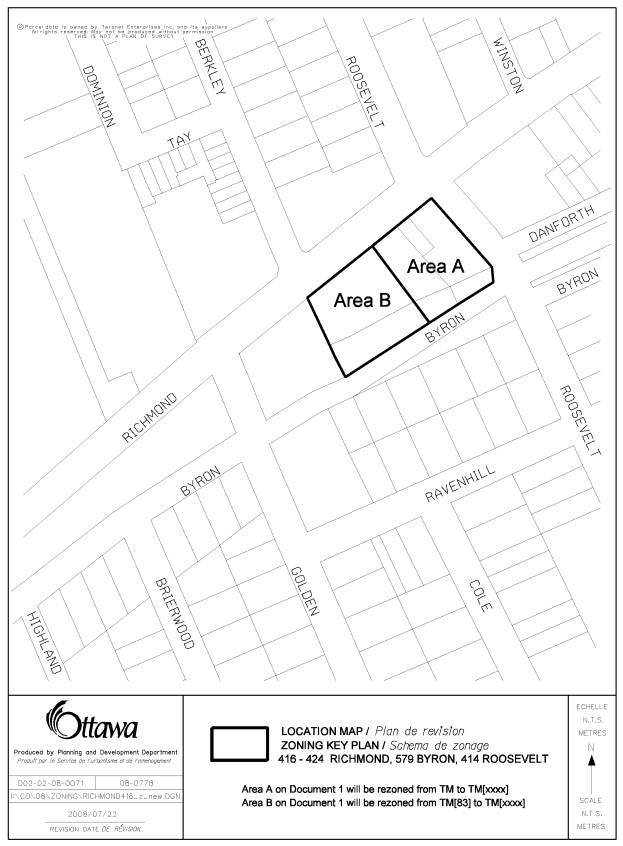
Document 1 Location Map for City’s Zoning By-law (2008-250)
Document 2 Location Map for the former City of Ottawa Zoning By-law
Document 3 Details of Recommended Zoning
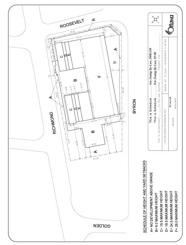
Document 4 Schedule of Height Limits and Setback Requirements
Document 5 Consultation Details
DISPOSITION
City Clerk’s Branch, Council and Committee Services to notify the owner, Bill Bourk/Bourk Family, 135 Walgreen Road Ottawa, Ontario K0A 1L0, applicant, FoTenn Consultants 223 McLeod Street, Ottawa, K2P 0Z8 Attention: Natalie Hughes, OttawaScene.com, 174 Colonnade Road, Unit #33, Ottawa, ON K2E 7J5, Ghislain Lamarche, Program Manager, Assessment, Financial Services Branch (Mail Code: 26-76) of City Council’s decision.
Planning, Transit and the Environment Department to prepare the implementing by-law, forward to Legal Services Branch and undertake the statutory notification.
Legal Services Branch to forward the implementing by-law to City Council.
LOCATION MAP FOR CITY’S ZONING BY-LAW
(2008-250) DOCUMENT 1
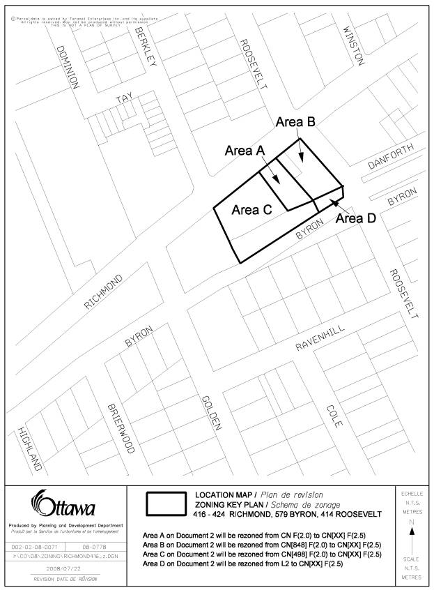
LOCATION MAP FOR THE FORMER CITY OF OTTAWA
ZONING BY-LAW DOCUMENT 2
DETAILS OF RECOMMENDED ZONING DOCUMENT 3
By-law No. 2008-250 – The subject lands will be rezoned as follows:
Area A on Document 1 will be rezoned from TM to TM[xxxx],
Area B on Document 1 will be rezoned from TM[83] to TM[xxxx],
And the lands zoned TM[xxxx] will be subject to the following zoning provisions:
- All yards and building heights shall be in accordance with Document 4.
- Despite the parking requirements, a minimum of 78 parking spaces for commercial uses must be provided on site.
Former City of Ottawa Zoning By-law (By-law No. 93-98)
Area A on Document 2 will be rezoned from CN F(2.0) to CN[XX] F(2.5)
Area B on Document 2 will be rezoned from CN[848] F(2.0) to CN[XX] F(2.5)
Area C on Document 2 will be rezoned from CN[498] F(2.0) to CN[XX] F(2.5)
Area D on Document 2 will be rezoned from L2 to CN[XX] F(2.5)
- All yards and building heights shall be in accordance with Documents 4.
- Section viii of Table 298 does not apply.
- Two loading spaces shall be required.
- Despite the parking requirements, a minimum of 78 parking spaces shall be provided for commercial uses.
5. Commercial
Parking spaces provided maybe available to anyone for parking purposes.
SCHEDULE OF HEIGHT LIMITS AND SETBACK REQUIREMENTS DOCUMENT 4
CONSULTATION DETAILS DOCUMENT
5
NOTIFICATION AND CONSULTATION PROCESS
Notification and public consultation was undertaken in accordance with the Public Notification and Public Consultation Policy approved by City Council for Zoning By-law amendments. One public meeting was also held in the community.
PUBLIC COMMENTS
The Ward Councillor is aware of this application and the staff recommendation. The City received 25 comments from the notification process. Of these comments, 13 respondents expressed concerns to the proposal, nine wanted more information and three expressed approval. A comment was also received from the local Community Association. Concerns expressed by the public and Community Association centred on issues of height, massing and traffic. The Ward Councillor also held a public meeting in the community, which was attended by over 100 people. Sixteen comments expressing concerns were received by staff from the public meeting. Issues raised at the public meeting were similar to those expressed through the City's Notification process. A summary of the comments received and a response to those comments are presented below.
SUMMARY OF PUBLIC INPUT
Reasons in Opposition
1. I object to any application to reduce the parking required by this proposal.
Response
With respect to the Zoning By-law 2008-250, while the applicant is proposing to provide three parking spaces less than the requirement for commercial parking, they are proposing to provide approximately 33 more parking spaces for residential parking. This results in a net total increase of 30 parking spaces above zoning requirements. It is the Department's position that the three commercial spaces not provided will not have a detrimental effect on the on-street parking situation.
2. How much and where will bicycle parking will be provided?
Response
The applicant is proposing to provide parking for 170 bicycles. Seventy-two of these are intended to be in spaces while 98 will be in lockers. The Zoning By-law 2008-250 requires 62 spaces.
3. When the applicant received minor variances to allow a 31-metre high building on the western portion of the property, they promised they would limit the height of any new building on the eastern portion to only six stories, with the central portion of the block being limited to two storeys. How can they be allowed to renege on their promise?
Response
The subject application heard by the Committee of Adjustment dealt only with Phase I. The applicant has the right to ask for an amendment to the current zoning for Phase II, despite any reference that may have been made to maintaining the zoning for Phase II of the development. Development proposals are often changed with building modifications coming forward to address such things as planning, engineering and financial objectives.
4. These high walls along the street edge will be covered in graffiti.
Response
To create a pedestrian friendly environment, the walls along the street are intended to consist of many windows.
5. The Developers are not following the Community Design Plan recently approved for this neighbourhood.
Response
As stated in this submission, it is the Department's position that the proposed development is consistent with the spirit and intent of the Community Design Plan.
6. This development is too big; the character of Westboro is being threatened.
Response
As presented in this submission, the proposed development is expected to add to the vitality of Westboro as well as its character. The terraced setback of the building will mitigate the impact expected from the proposed additional two storeys.
7. This development will worsen the already bad traffic situation in the area. The intersection at Byron and Roosevelt needs to be signalized.
Response
The traffic brief submitted in support of the zoning application indicates that the expected traffic generated from the proposed development is low and will have minimal effect on the adjacent roads/intersections. The traffic study does not identify the requirement of traffic signals at Byron/Roosevelt intersection. Nevertheless this option will be reviewed again at the time of Site Plan application and if the traffic counts warrant traffic signals, it would be installed.
8. More efforts should have been taken to preserve the access to sun exposure.
Response
A sun/shadow study undertaken for this proposal indicates that the shadowing impact on surrounding properties will be minimal and is in keeping with the impact typically found in an urban setting.
9. I'm afraid that this proposal will set a precedent for even higher buildings, which will result in Richmond Road becoming a canyon.
Response
It is the Department's position that the terraced setbacks proposed along Richmond Road, as the building gets higher, will help mitigate the "canyon effect" along that street. As well, while there are sound planning reasons why an increase in height is appropriate for this property, it does not mean that any future requests for an increase in height will necessarily be appropriate. Each application must be evaluated on its own merits.
10. This proposal will place even more strain on the already bad on-street parking situation.
Response
Under the Zoning By-law 2008-250, along Mainstreets, onsite parking may be provided for anyone, not just the uses located on the site. The applicant is planning up to 60 spaces for public use. It is anticipated that this will reduce the amount of demand for on-street parking.
Reasons in Favour
1. The proposed design fits in with the overall neighbourhood.
2. The stepping back of the building will allow for sunlight to reach street level.
3. I look forward to the new addition to the streetscape and the vibrancy it will add to the retail development in the village.
4. This proposal follows the City's mandate for increased density within the Greenbelt, to lessen suburban sprawl.
5. This proposal will allow people to walk to work and take public transit to decrease the amount of personal vehicles on the road at peak times.
6. The design of this development has been well thought out and is sensitive to the community.
7. We support the higher building (eight storeys) as it will result in a building that is less boxy than if it were only six storeys.
8. We support intensification as an environmentally, socially and economically sound policy for Ottawa.
June 17, 2008 - PUBLIC MEETING COMMENTS
The Ward Councillor held a public meeting in the local community on June 17, 2008. Over 100 people attended this meeting. Sixteen comments expressing concern were received. Concerns raised at the meeting were similar to those expressed by the City’s Public Notification process.
COUNCILLOR’S COMMENTS
Councillor Leadman is aware of the application.
COMMUNITY ORGANIZATION COMMENTS
The Westboro Community Association provided the following comments:
The WCA wishes to make the following comments on this application:
Building height: A majority of community members have expressed
clear opposition to the building’s proposed height (28 metres/8 storeys) and
have requested that the current limit of 18‑20 metres/6 storeys as
provided under the City of Ottawa Zoning By-Law, Draft Comprehensive Zoning
By-Law and Richmond Road/Westboro Community Design Plan be maintained. This
would also respect the provisions of the original Committee of Adjustment
decision granting a 13-metre height variance for phase 1 of the Westboro
Station project (attached). The WCA strongly concurs.
Traffic: Many community members have raised concerns
about traffic, particularly potential impacts on adjacent local streets
including Golden, Roosevelt and the Roosevelt/Byron intersection which the
ongoing Westboro/Highland Park Area Traffic Management Study has identified as
having the highest accident rate of any in the area. The WCA shares this
concern. Furthermore, the WCA questions the assumption made in the applicant’s
transportation brief (see p. 20, Findings & Recommendations,) that there
will be no net increase in commercial/retail-generated traffic. Future traffic
volumes will depend entirely on what kind of retail operations locate in
building and, given recent and current trends in Westboro Village, these will
inevitably include “destination shopping” stores and services that will
generate more traffic than any of the existing businesses.
Pedestrian environment: Some community members expressed concern about
potential wind-tunnel effects on Richmond Road when combined with Phase 1 of
this project as well higher-rise buildings across the street. The WCA concurs
and requests that an analysis of current and potential street-level wind
conditions be undertaken and the results made public before this application
goes to Planning & Environment Committee.
Questions and concerns have also been raised regarding
certain design aspects of the proposal, including the lack of elevation
drawings for the Roosevelt and Byron Avenue sides of the proposal. It is our
understanding that this will be addressed during the site plan control process.
Could you please confirm whether the WCA will have access to, and be able to
comment on, design issues at that time.
Response to Comments from the Westboro Community Association
As indicated in this submission, it is the Department’s
position that the proposed development represents an excellent example of
compatible intensification that will allow a development that will enhance the
streetscape and overall character of Westboro.
The proposed height increase is in keeping with the Mainstreet policies
of the Official Plan as well as the spirit and intent of the Community Design
Plan. Staff has reviewed the submitted
traffic report for this zoning application.
The expected traffic generated by the proposed development will have
minimal effect on the adjacent roadway network. As well, the setbacks recommended for the proposed building will
help ensure that the proposal does not create undesirable wind conditions.