|
2. OFFICIAL PLAN AND ZONING -
100, 300 AND 645 LONGFIELDS DRIVE PLAN OFFICIEL ET
ZONAGE – 100, 300 ET 645, PROMENADE LONGFIELDS |
Committee recommendationS AS
AMENDED
(This application is subject to Bill 51)
That Council:
1. Approve and adopt an amendment to the
Longfields, Davidson Heights Communities, South Merivale Business Park
Secondary Plan - Area 1, 2 and 3, Volume 2A of the Official Plan for lands
located at Part of 100 and 645 Longfields Drive as shown in Document 1 and
detailed in Document 3;
2. Approve an amendment to the former City
of Nepean Zoning By-law to change the zoning of 100, 300 and 645 Longfields
Drive as shown in Document 4 and 5 and as further detailed in Document 6;
3. Approve an amendment to the
Comprehensive Zoning By-law to change the zoning of 100, 300 and 645 Longfields
Drive as shown in Document 7and 8 and as further detailed in Document 9; and
4. Approve
that Document 3 be amended in order that the area along the north side of
Highbury Park Drive west of Longfields Drive, equivalent to a row of single
family lots, be redesignated from “Urban Natural Feature” to “General Urban
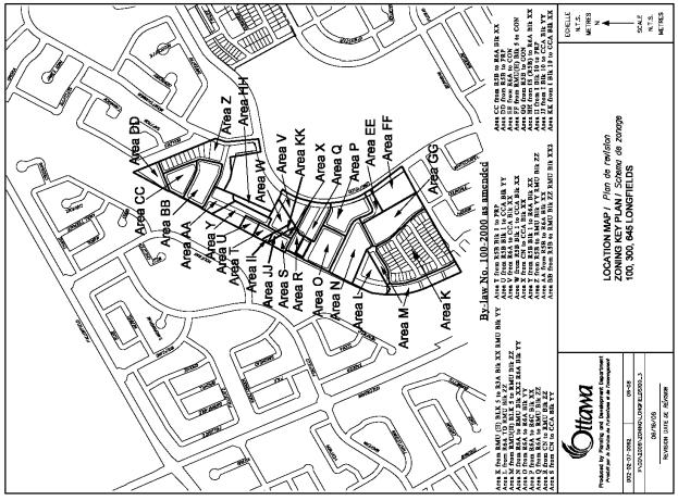
Area” and that Document 5 and 8, Zoning Key Plans, be amended by extending Area
K along the north side of Highbury Park Drive west of Longfields
Drive for a depth of one row of single family lots.
RecommandationS modifiÉeS du Comité
(Cette demande est assujettie au Règlement 51)
Que le Conseil:
1. approuve
et d’adopter une modification au Plan secondaire pour les quartiers de
Longfields et de Davidson Heights ainsi que pour le parc commercial de
Merivale-Sud – secteurs 1, 2 et 3, Volume 2A du Plan officiel, pour les
terrains occupant une partie du 100 et du 645, promenade Longfields, comme
l’illustre le document 1 et le précise le document 3;
2. approuve
une modification au Règlement de zonage de l’ancienne Ville de Nepean visant à
changer la désignation de zonage des propriétés situées aux 100, 300 et 645,
promenade Longfields, comme l’illustrent les documents 4 et 5 et le précise le
document 6;
3. approuve
une modification au Règlement de zonage général visant à changer la désignation
de zonage des propriétés situées aux 100, 300 et 645, promenade Longfields,
comme l’illustrent les documents 7 et 8 et le précise le document 9; et
4. approuve
que le Document 3 soit modifié afin que la désignation de zonage du secteur
situé le long du côté nord de la promenade Highbury Park, à l’ouest de la
promenade Longfields, et équivalant à une rangée de maisons unifamiliales, soit
changée de « Caractéristiques naturelles urbaines » à « Secteur
urbain général », et que les Documents 5 et 8, plans de zonage clés,
soient modifiés en agrandissant le secteur K situé le long du côté nord de la
promenade Highbury Park, à l’ouest de la promenade Longfields, d’une profondeur
égale à une rangée de maisons unifamiliales.
Documentation
1.
Deputy
City Manager's report Planning, Transit
and the Environment dated 26 June 2008 (ACS2008-PTE-PLA-0135).
Report to/Rapport au :
Planning and
Environment Committee
Comité de l'urbanisme et de l'environnement
and Council / et au Conseil
26 June 2008 / le 26 juin 2008
Submitted by/Soumis par : Nancy Schepers, Deputy City Manager
Directrice
municipale adjointe,
Planning,
Transit and the Environment
Urbanisme,
Transport en commun et Environnement
Contact Person/Personne ressource : Karen Currie,
Manager / Gestionnaire, Development Approvals / Approbation des demandes
d'aménagement, Planning Branch/ Direction de l'urbanisme
(613) 580-2424, 28310 Karen.Currie@ottawa.ca
SUBJECT:
|
Official plan and zoning - 100, 300
and 645 Longfields drive (file no. d01-01-07-0006 and D02-02-07-0062) |
|
|
|
OBJET :
|
Plan officiel et zonage – 100, 300 et 645,
promenade longfields |
REPORT RECOMMENDATIONS
That the Planning and Environment
Committee recommend Council:
1. Approve
and adopt an amendment to the Longfields, Davidson Heights Communities, South
Merivale Business Park Secondary Plan - Area 1, 2 and 3, Volume 2A of the
Official Plan for lands located at Part of 100 and 645 Longfields Drive as
shown in Document 1 and detailed in Document 3;
2. Approve
an amendment to the former City of Nepean Zoning By-law to change the zoning of
100, 300 and 645 Longfields Drive as shown in Document 4 and 5 and as further
detailed in Document 6; and
3. Approve an amendment to the Comprehensive Zoning By-law to change the zoning of 100, 300 and 645 Longfields Drive as shown in Document 7and 8 and as further detailed in Document 9.
RECOMMANDATIONS DU RAPPORT
Que le Comité de l’urbanisme et de
l’environnement recommande au Conseil :
1. d’approuver et d’adopter
une modification au Plan secondaire pour les quartiers de Longfields et de
Davidson Heights ainsi que pour le parc commercial de Merivale-Sud – secteurs
1, 2 et 3, Volume 2A du Plan officiel, pour les terrains occupant une partie du
100 et du 645, promenade Longfields, comme l’illustre le document 1 et le
précise le document 3;
2. d’approuver une
modification au Règlement de zonage de l’ancienne Ville de Nepean visant à
changer la désignation de zonage des propriétés situées aux 100, 300 et 645,
promenade Longfields, comme l’illustrent les documents 4 et 5 et le précise le
document 6; et
3. d’approuver une
modification au Règlement de zonage général visant à changer la désignation de
zonage des propriétés situées aux 100, 300 et 645, promenade Longfields, comme
l’illustrent les documents 7 et 8 et le précise le document 9.
BACKGROUND
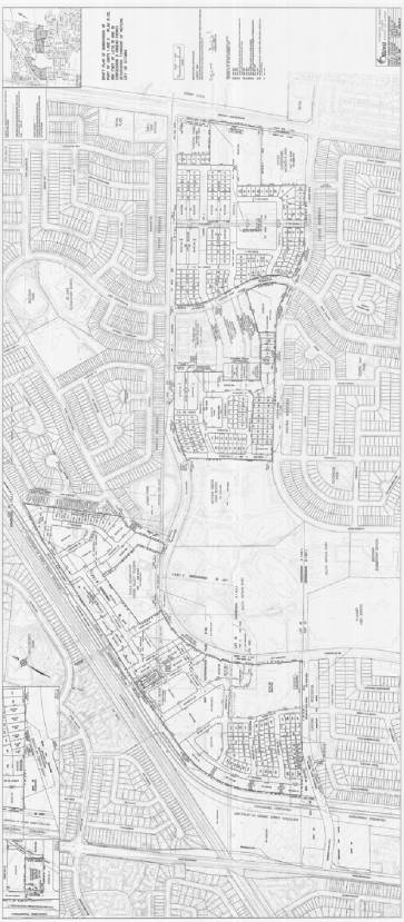
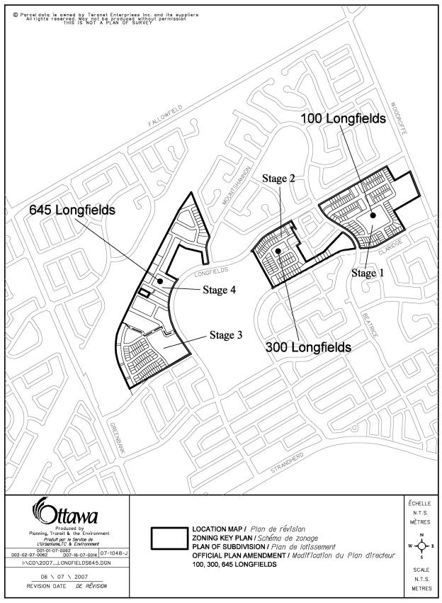
The subject site, known as the City of Ottawa's Longfields Subdivision, consists of approximately 50 hectares located within the South Nepean Community of Barrhaven. The subject property, shown in Document 1, abuts Woodroffe Avenue to the east, the CN rail line to the west and existing residential development to the south and north. The proposed development has four neighbourhoods (called stages) which are also shown on Document 1. The subject property is currently vacant, reasonably flat and with the exception of the Highbury woodlot in the western portion of the site, is somewhat featureless. The area surrounding the subject property has largely been developed as a low to medium density residential community over the last 20 years.
In the 1970s, the property was part of a larger 108.0-hectare parcel acquired by the former City of Nepean for economic development purposes. In 1989 the City of Nepean Official Plan and the Regional Municipality of Ottawa-Carleton Official Plan were amended to permit residential development on the subject property. The property was granted Draft Approval on May 25, 1998 for the development of a residential subdivision. The draft plan effectively divided the property into large blocks for re-subdivision and created the key road allowances including Longfields Drive, Highbury Park Drive and Beatrice Drive. In 2002 the new City of Ottawa approved a concept plan which proposed the development of some 1300 residential units. Between the period of 1998 and 2007, approximately 58.0 hectares of the 108.0 hectares, have been developed or reserved for many uses including two high schools, three elementary schools, non-profit housing, a Funeral Home, South Nepean Community Park and land for the south-west transitway corridor.
The Proposal
The applicant, on behalf of the City of Ottawa, has submitted applications for amendments to the Longfields, Davidson Heights Communities, South Merivale Business Park Secondary Plan and Zoning By-law which are the subject of this report. An application for a Plan of Subdivision has also been submitted and reviewed concurrently with the Official Plan and Zoning By-law amendment applications. The proposed concept plan, which forms the basis for the proposed Secondary Plan and Zoning By-law Amendments and Draft Plan of Subdivision, is estimated to yield approximately 1400 residential units of which 25 per cent are single detached units and semi-detached units, 25 per cent street townhouse units and 50 per cent multiples such as stacked townhouses and low and medium rise apartments. The current plan as developed by the City is seen as a smart growth demonstration community showcasing 20/20 growth management principles, innovative planning and design elements and sustainable development practices.
The Secondary Plan amendment proposes a change in policy to allow for low rise apartments up to four floors in a portion of the subject lands designated as Low Density Residential and medium rise apartment buildings up to eight floors in a portion of the lands designated as Mixed Density Residential.
Although the subject lands are already zoned to permit a wide range of residential and commercial development, in order to achieve the type of development and streetscape desired in keeping with the current plan, an amendment is required to both the former City of Nepean Zoning By-law and Comprehensive Zoning By-law to permit different or additional uses and new zoning standards.
DISCUSSION
On October 10, 2007, City Council approved the implementation strategy for Community Lands Development Projects including the Longfields Subdivision project. This approval was based on a Business Plan, as approved by Council on September 28, 2005, which provided the Real Property Asset Management Branch with the following mandate:
Longfields Subdivision
"Develop a framework and implement a smart growth demonstration community on the City-owned lands in Longfields. Within the guidelines established by the Council approved " Longfields Concept Plan", the development will focus on a balanced return on investment, affordable housing and the environment. With the intent to provide a greater range of development opportunities with the private sector, this project will embrace innovative planning principles and design standards that are in line with the 20/20 Vision."
To this end, a concept plan was developed which requires any proposed development to reflect the following principles:
- a modified grid road network complemented by a rapid bus corridor;
- compact development;
- four distinct neighbourhoods embracing highly visible open spaces and parks in each neighourhood;
- an array of housing types for all income ranges;
- neighbourhood conveniences and integration of a future transitway station with the new community via a public courtyard;
- a network of pathways for pedestrians and cyclists;
- extensive landscaping and the preservation of environmental features including the Highbury woodlot;
- selective use of rear laneways to showcase alternative development forms and to take advantage of subject property's Longfields Drive frontage which cannot be accessed directly with driveways.
The proposed plan calls for four neighbourhoods (called stages) of development described as follows:
Stage 1 located east of Beatrice Drive is intended to be the area where the main objective is to create a neighbourhood of high quality urban/architectural design. This provides for lots where garages will be largely unseen from the street; specifically the intent here is to create a streetscape dominated by strong housing elevations and to try and minimize the view of the garage doors from the street. To achieve this, a combination of residential unit types will be built that will be accessed via rear laneways thus enabling the positioning of the garages behind the homes. Other streets in Stage 1 are intended to be built with front loaded singles where the garage will be either attached or detached at the rear of the lot. Along Woodroffe Avenue, between the existing funeral home and elementary school, the plan calls for the creation of a multiple residential block and institutional uses such as a church. The focal point of this neighbourhood will a 2.2-hectare park centrally located and highly visible from most streets in the neighbourhood.
Stage 2, located between Mother Theresa High School and Beatrice Drive, has been designed to incorporate a complementary transition between the existing non-profit development and new development. The treatment of Longfields Drive continues as per Stage 1 along with the placement of residential units facing this important edge.
Stage 3, located north of future Highbury Drive and Stage 4, will be a pocket of more conventional singles, semis and street townhouses with the main objective being to provide buildings that are designed to a high standard of environmental sustainability. The buildings are to be oriented around a series of roads accessing the area's primary feature being the Highbury woodlot which in turn is intended to be preserved and made accessible via an internal pedestrian pathway system yet to be designed. This neighbourhood abuts the transitway recreational corridor proposed to the west; to this end, three pedestrian links are provided to enable the residents of this neighbourhood to access this recreational corridor running north south at this location.
Stage 4, located adjacent to the future transitway and Boulder Way, is designed to provide a "Village Centre" for this subdivision. It will encompass a series of public streets providing strong connections from Longfields Drive and the proposed transitway station as well as the mixed use node proposed along and abutting the main street bisecting the public courtyard. The commercial component (up to 2323 square metres) of this neighbourhood is intended to be integrated with some of the multiple residential buildings.
Another important feature of this neighbourhood will be the integration of the recreational pathway running along the transitway corridor with the new community. The said recreational pathway is intended to intersect with the existing east west recreational pathway running under the CN rail line at the public courtyard and will then continue further east into the new community.
Recommendation 1 - Secondary Plan Amendment
The lands are designated mainly as General Urban Area in the Official Plan, with the exception of the Highbury Woods which are designated urban natural feature (UNA No. 48). According to Schedule A of the Longfields, Davidson Heights Communities, South Merivale Business Park Secondary Plan, the subject property is designated for Low Density Residential east of Beatrice Drive and Mixed Density Residential west of Beatrice Drive. The Low Density Residential designation is intended to permit singles, townhouses and stacked townhouses within a maximum net density of 30 units per hectare. The Mixed Density Residential designation is intended to permit all of the uses allowed in the Low Density Residential designation as well as low rise apartment buildings up to four floors and is intended to accommodate 900 units west of on the lands so designated on the subject property. This designation also permits neighbourhood commercial uses.
The Secondary Plan amendment requests a modification to Section 2.4.2 - Low Density Residential to permit the proposed low rise apartments up to four floors in height for the proposed multiple dwelling block facing Woodroffe Avenue. Section 2.3.2 establishes policies for those lands designated Mixed Density Residential which affects Stages 2-4 lands. Under this section, a maximum building height of four floors is permitted whereas the proposed plan contemplates some buildings in the Stage 4 lands to reach up to eight floors. Therefore an amendment is required to recognize this additional height limit on the Stage 4 lands.
The Department is satisfied that the proposed amendment is consistent with the policies of the Official Plan for General Urban Areas and is consistent with the policies of the Longfields Secondary Plan. Given the location of the proposed apartment buildings adjacent to the future transitway station and a major arterial, the application will allow for an appropriate form of development that is in keeping with the Official Plan's policies on intensification and increasing the variety of residential types offered in the South Nepean Community.
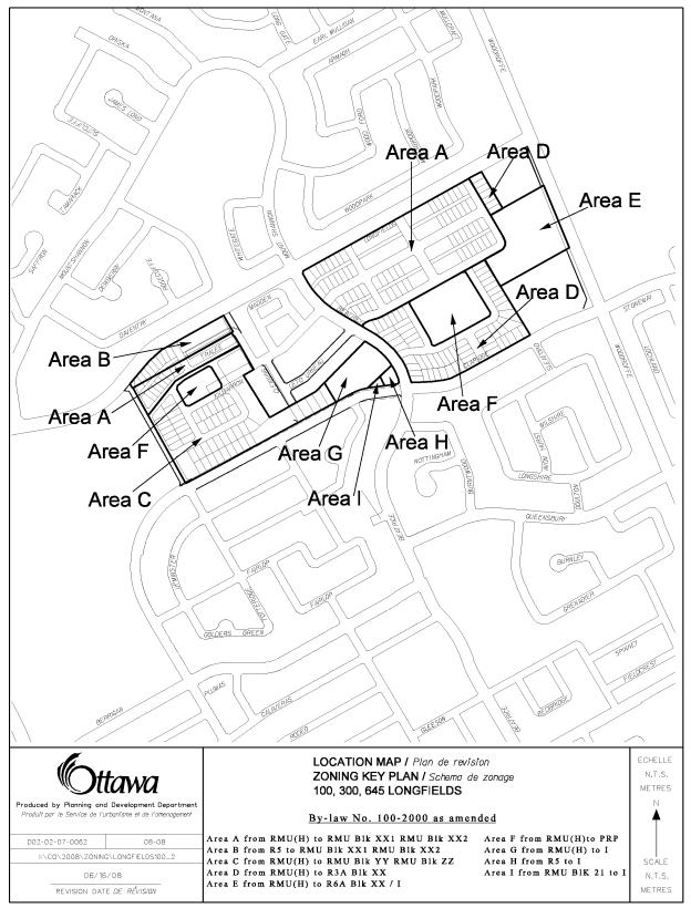
Recommendation 2 - Former City of Nepean Zoning By-law
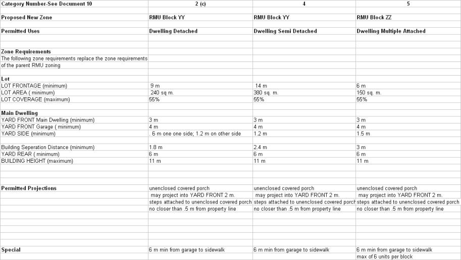
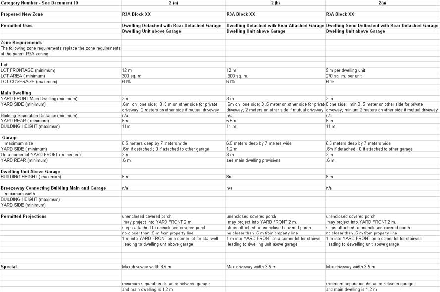
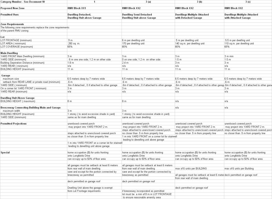
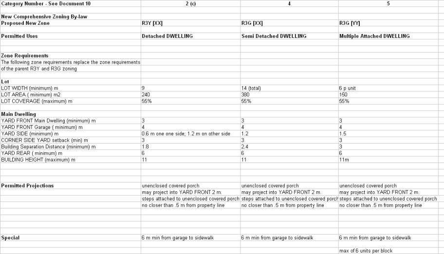
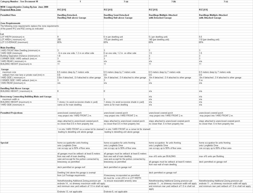
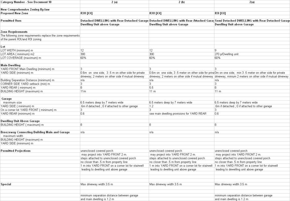
In order to meet the intent of the various new urbanism features previously discussed and the proposed plan, several amendments to the former City of Nepean Zoning By-law are proposed. The Zoning By-law amendment proposes a range of residential zones from a single detached dwelling zone (R3A) up to an apartment zone (R6B). Special zoning provisions that cover the development of three housing types including single detached, semis and townhouses on rear lanes are also being recommended. Included in the rear lane development product is the provision to allow an accessory residential unit on top of garages. For garages which are accessed from the street and not a rear lane, provisions are being recommended to ensure the garages are setback from the main dwelling to reduce their impact on the street and are of a minimum size to ensure an adequate amenity area is maintained.
Side yards are proposed to be only wide enough to ensure good access to the back yard on one side which will enable the development of an efficient lotting pattern without compromising the streetscape.
Other zone categories proposed is a Commercial Core Area zone (CCA) which is applicable to the three commercial blocks located around the public courtyard adjacent to the transitway station in Stage 4. Provisions have been incorporated to allow up to 2323 square metres of commercial space in mixed use buildings which will also contain employment and residential uses. An Institutional/Residential Multiple Attached Dwelling/Low Rise apartment zone is planned for the block located on west side of Woodroffe Avenue between the funeral home and elementary school to allow for the possible construction of a church and seniors' residence.
Finally, three additional zones are proposed including a Conservation (Con) zone applicable to the Highbury Woodlot, a Parks and Recreation (PRP) zone applicable to all public parks and an Institutional (I) zone applicable to the institutional block on the north west corner of Claridge Drive and Longfields Drive in keeping with the 2002 Concept Plan.
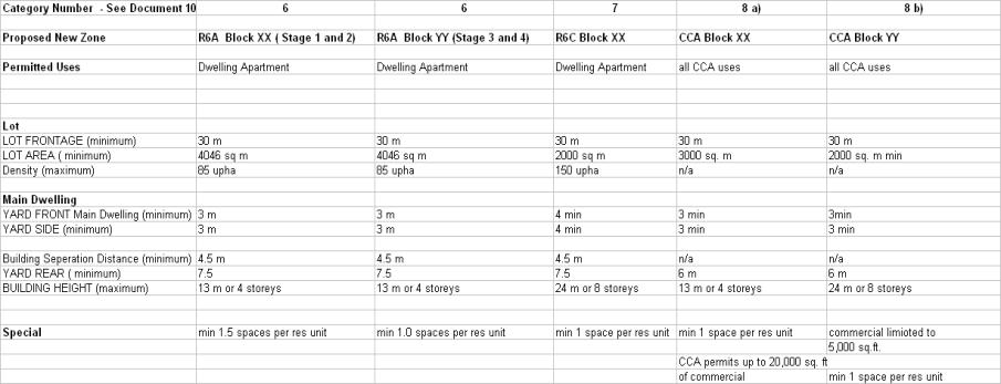
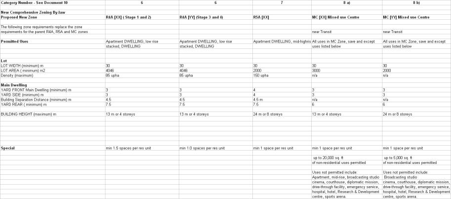
Recommendation 3 - Comprehensive Zoning By-law
The Comprehensive Zoning By-law was passed by City Council on June 25, 2008. It is recommended that the relevant zoning provisions in this new Zoning By-law be amended as shown in Document 7 and 8 and detailed in Document 9. The Comprehensive Zoning By-law will maintain similar corresponding zone designations, as amended, of the former City of Nepean Zoning By-law.
Conclusion
In summary, the Department supports the Secondary Plan and Zoning By-law amendment applications because they respond to the policies in the Official Plan that speak to the creation of unique, compact and innovative developments that in the long term result in more efficient use of the City infrastructure and resources. The proposal is a definite movement towards the creation of a environmentally sustainable community that is in line with the 20/20 vision.
ENVIRONMENTAL
IMPLICATIONS
As documented in the Environmental Impact Statement and Preliminary Tree Preservation Reports, the subject property is dominated by open field habitat, with some young forest and shrub thickets. The vegetation communities generally reflect disturbed conditions with limited ecological features and functions. The Highbury Woodlot which is designated as an Urban Natural Feature (UNA No. 48), will be preserved even though it is considered by the environmental consultant to have limited features and functions and considered as having low to moderate value.
CONSULTATION
Notice of the applications were carried out in accordance with the City's Public Notification and Consultation Policy. In addition, four public open houses regarding the concept/subdivision plan for the proposed subdivision were held at the Walter Baker Centre on:
· March 6, 2007,
· October 17, 2007, ( Public Meeting for Subdivision Application)
· January 14, 2008,
· May 7, 2008.
The City received both positive and negative comments to the applications at the open houses and through written correspondence. Many people asked questions with respect to the height of buildings, the location of affordable housing, amount of greenspace and increased traffic. After looking at the presentation boards and getting more information, most people were very positive about the enhanced concept plan and many liked the modified grid layout, well-spaced parks, integration with rapid transit, mix of housing types, and the "European flavour" of the proposed development in the vicinity of the transit station. The presentation board that showed the relative heights of buildings in the vicinity of the proposed transit station courtyard helped allay many of the concerns about building height in this area. With respect to concerns regarding increased traffic, the Traffic Impact Study concluded that increased traffic volumes and any intersection impacts as a result of the proposed development, would be minor. The proposed development was taken into consideration when the existing and future roads, including the soon to be built Highbury Park Drive, were designed. The traffic study also concluded that the area is well served by existing sidewalks, bicycle systems and transit service. These will all be enhanced by the time the project is built out.
The ability to provide for affordable housing units on an inclusionary basis within Neighbourhood 4 without reserving specific blocks for affordable housing was well received by all including social housing group representatives. Finally, in response to concerns regarding loss of open space, overall on the proposed subdivision, there will be an over-dedication of lands for park purposes.
Comments were also received from the Ottawa Forests and Greenspace Advisory Committee indicating that a larger area of the wooded portions of the proposed subdivision should be retained and protected. As well, they requested that any wooded areas to be retained be zoned EP- (Environmental Protection).
Staff are recommending an EP zoning for the Highbury Woodlot, however, the area to be preserved is not being expanded beyond the boundaries, as identified in the Official Plan, of the designated Urban Natural Feature (UNA No. 48).
The Ward Councillor is aware of this application and the staff recommendation.
FINANCIAL IMPLICATIONS
SUPPORTING DOCUMENTATION
Document 2 Plan of Subdivision
Document 3 Proposed Official Plan Amendment
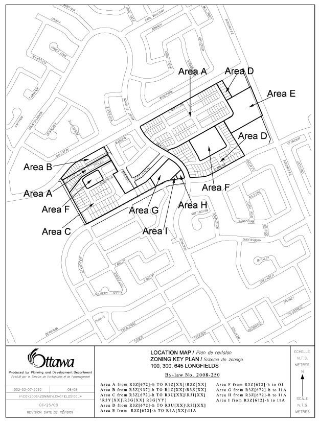
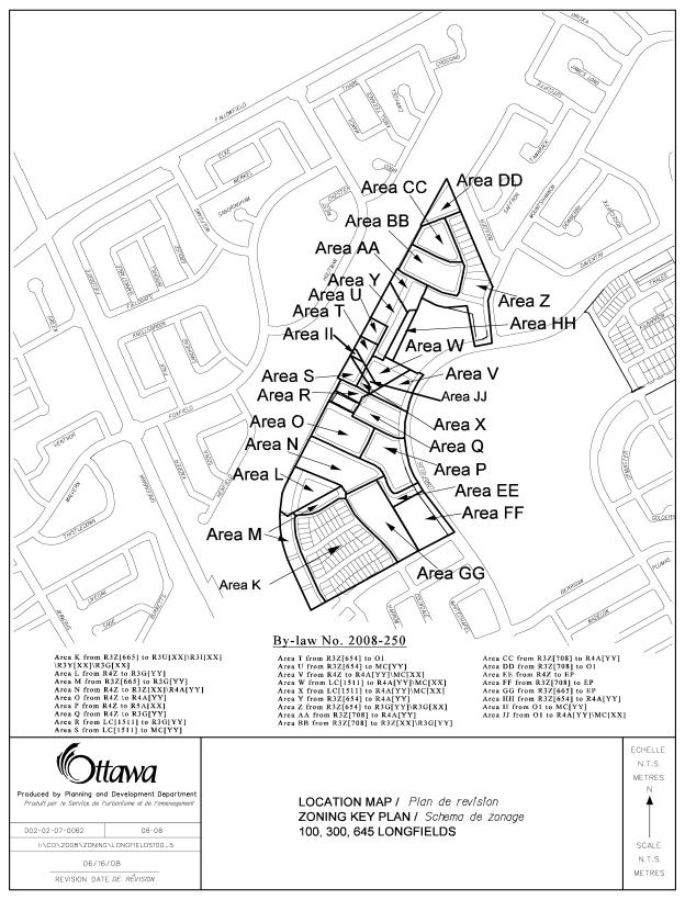
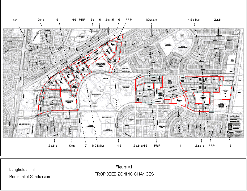
Document 4 and 5 Zoning Key Plan - Former City of Nepean Zoning By-law
Document 6 Details of Recommended Zoning - Former City of Nepean Zoning By-law
Document 7 and 8 Zoning Key Plan - Comprehensive Zoning By-law
Document 9 Details of Recommended Zoning - Comprehensive Zoning By-law
Document 10 Development Plan - Proposed Zoning Changes
DISPOSITION
City Clerk's Branch, Council and Committee Services to notify the owner, City of Ottawa (RPAM), applicant, Daniel Paquette, Paquette Planning Associates Ltd., 56 Hutchison Avenue, Ottawa, Ontario, K1Y 4A3, Ottawa Scene. com, 174 Colonnade Road, Unite #33, Ottawa, ON K2E 7J5, Ghislain Lamarche, Program Manager, Assessment, Financial Services Branch (Mail code: 26-72 of City Council's decision.
Planning, Transit and the Environment Department to prepare the by-law adopting the Official Plan Amendment and the implementing Zoning By-law, forward to Legal Services Branch, and undertake the statutory notification.
Legal Services Branch to forward the adopting and implementing by-laws to City Council.
LOCATION MAP DOCUMENT 1

PLAN OF SUBDIVISION DOCUMENT 2
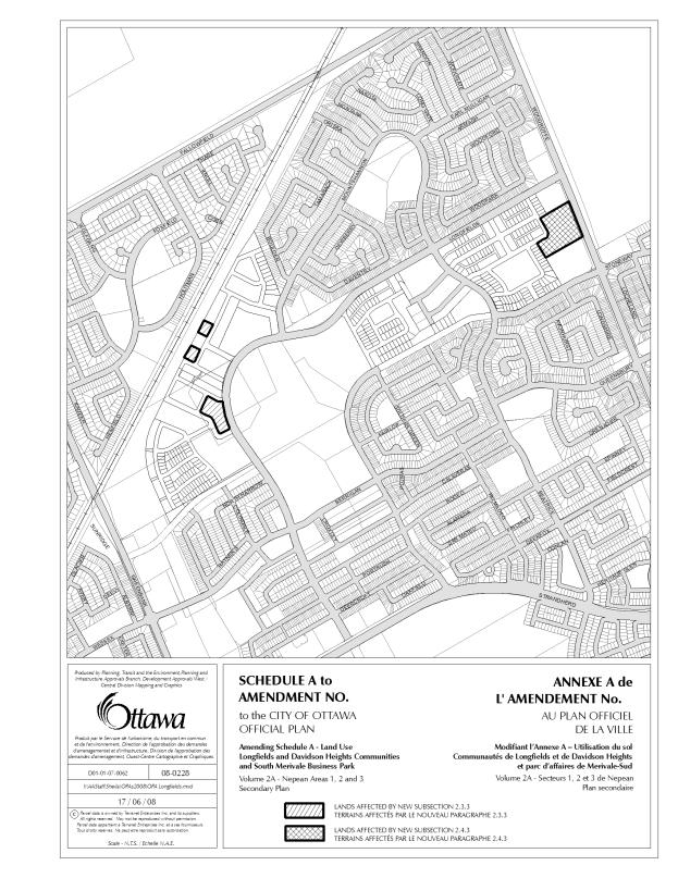
PROPOSED OFFICIAL PLAN AMENDMENT DOCUMENT 3
|
|

Official Plan Amendment XX/Modifications du Plan
directeur
To the Official Plan of the City of Ottawa
OFFICIAL PLAN AMENDMENT
AMENDMENT No. TO THE CITY OF OTTAWA OFFICIAL PLAN
INDEX
COMPONENTS
PART A THE PREAMBLE
PART B – THE AMENDMENT
1.0 Introduction
2.0 Details
3.0 Implementation
COMPONENTS
PART A - THE PREAMBLE does not constitute part of this amendment.
PART B - THE AMENDMENT, consisting of the following text constitutes
Amendment No.XX to the City of Ottawa Official Plan.
PART A - THE PREAMBLE
1.0 PURPOSE:
The purpose of this Official Plan Amendment is to amend the policies of the Longfields, Davidson Heights Communities, South Merivale Business Park Secondary Plan - Areas 1, 2 & 3 contained in Volume 2A of the City of Ottawa Official Plan for land located in the City of Ottawa’s Longfields Subdivision at 100 and 645 Longfields Drive. Specifically the proposal is to amend Sections 2.3 and 2.4 to allow for a proposed low rise apartment building of up to four fours in height on a portion of the land designated as Low Density Residential and to allow for medium rise apartment buildings up to eight stories on some portions of the land designated as Mixed Density Residential.
2.0 LOCATION
The subject site, shown on the attached Location Map, consists of approximately 50 hectares and is located within the South Nepean Community of Barrhaven, in the area also known as the Longfields community. The subject property abuts Woodroffe Avenue to the east, the CN rail line to the west and existing residential development to the south and north.
3.0 BASIS
Background
The City of Ottawa's Longfields
Subdivision consists of approximately 50 hectares located within the South
Nepean Community of Barrhaven, in the area also known as the Longfields
community. The subject property is
currently vacant, resonably flat and with the exception of the Highbury woodlot
in the western portion of the site, is somewhat featureless. The area surrounding the subject property
has largely been developed as a low to medium density residential community
over the last 20 years.
In the 1970s, the property was part of a larger 108.0
hectare parcel acquired by the former City of Nepean for economic development
purposes. In 1989 the City of Nepean
Official Plan and the Regional Municipality of Ottawa-Carleton Official Plan
were amended to permit residential development on the subject property. The property was granted Draft Approval on
May 25, 1998 for the development of a residential subdivision. The draft plan
effectively divided the property into large blocks for re-subdivision and
created the key road allowances including Longfields Drive, Highbury Park Drive
and Beatrice Drive. In 2002 the new
City of Ottawa approved a concept plan which proposed the development of some
1300 residential units. Between the
period of 1998 and 2007, approximately 58.0 hectares of the 108.0 hectares,
have been developed or reserved for many uses including two high schools, three
elementary schools, non-profit housing, ag Funeral Home, South Nepean Community
Park and land for the south-west transitway corridor.
The applicant, on behalf of the
City of Ottawa, has submitted applications for amendments to the Longfields, Davidson Heights Communities,
South Merivale Business Park Secondary Plan and Zoning By-law. An application
for a Plan of Subdivision has also been submitted and reviewed concurrently
with the Official Plan and Zoning By-law amendment applications.
The proposed concept plan, which
forms the basis for the proposed Secondary Plan and Zoning By-law Amendments
and Draft Plan of Subdivision, is estimated to yIeld approximately 1400
residential units of which 25% are single detached units and semi-detached
units, 25% street townhouse units and 50% multiples such as stacked townhouses
and low and medium rise apartments. The
Longfields Subdivision current plan as developed by the City's Real Estate
Services Division of RPAM, is seen as a smart growth demonstration community
showcasing 20/20 growth management principles, innovative planning and design
elements and sustainable development practices.
Rationale
The lands are designated mainly as General Urban Area in the Official Plan, with the exception of Highbury Woods, which are, designated urban natural feature (UNA No. 48). According to Schedule A of the Longfields, Davidson Heights Communities, South Merivale Business Park Secondary Plan, the subject property is designated for Low Density Residential east of Beatrice Drive and Mixed Density Residential west of Beatrice Drive. The Low Density Residential designation is intended to permit singles, townhouses and stacked townhouses within a maximum net density of 30 units per hectare. The Mixed Density Residential designation is intended to permit all of the uses permitted in the Low Density Residential designation as well as low-rise apartment buildings up to four floors and is intended to accommodate 900 units west of on the lands so designated on the subject property. This designation also permits neighbourhood commercial uses.
The Secondary Plan amendment requests a modification to Section 2.4.2 - Low Density Residential to permit the proposed low-rise apartments up to four floors in height for the proposed multiple dwelling block facing Woodroffe Avenue. Section 2.3.2 establishes policies for those lands designated Mixed Density Residential, which affects Stages 2-4 lands. Under this section, a maximum building height of four floors is permitted whereas the proposed plan contemplates some buildings in the Stage 4 lands to reach up to eight floors. There are three blocks, as identified on Schedule A to this amendment, within the Mixed Density Residential designation where the development of mixed used and residential apartment buildings could have a height of up to eight floors. Therefore an amendment is required to recognize this additional height limit on this portion of the subject lands.
The Department is satisfied that the proposed amendment is consistent with the policies of the Official Plan for General Urban Areas and is consistent with the policies of the Longfields Secondary Plan. Given the location of the proposed apartment buildings adjacent to the future transitway station and a major arterial, Woodroffe Avenue, the application will allow for an appropriate form of development that is in keeping with the Official Plan's policies on intensification and increasing the variety of residential types and affordability offered in the South Nepean Community.
PART B - THE AMENDMENT
1. INTRODUCTION
All
of this part of the document entitled Part B - The Amendment, consisting of the
following text constitutes Amendment No. XX to the City Council
Approved Official Plan.
2. DETAILS
That the Longfields, Davidson Heights Communities, South Merivale Business Park Secondary Plan - Areas 1, 2 & 3 in Volume 2A of City of Ottawa Official Plan is hereby amended as follows:
1. Section 2.3 of the Secondary Plan is hereby amended by adding the following new policy Subsection 2.3.3 Special Policies at the end of Subsection 2.3.2:
“Notwithstanding the permitted uses in Subsection 2.3.1, and the policies of Subsection 2.3.2 to the contrary, on the Mixed Density Residential lands identified on the attached Schedule A, a medium rise apartment building with a maximum building height of eight stories is permitted.”
2.
Section 2.4 of the
Secondary Plan is hereby amended by adding the following new policy Subsection
2.4.3 Special Policies at the end of Subsection 2.4.2:
“Notwithstanding the
permitted uses in Subsection 2.4.1 and the policies of Subsection 2.4.2 to the
contrary, on the Low Density Residential lands identified on the attached
Schedule A, a low rise apartment building of four stories is permitted”
3. IMPLEMENTATION
The implementation of this
Amendment to the Official Plan document shall be in accordance with the
respective policies of the Official Plan of the City of Ottawa.
ZONING KEY PLAN – FORMER CITY OF NEPEAN
ZONING BY-LAW DOCUMENT 4
ZONING KEY PLAN – FORMER CITY OF NEPEAN
ZONING BY-LAW DOCUMENT 5