|
4. ZONING
- 741 BLAIR ROAD ZONAGE
- 741, CHEMIN BLAIR |
Committee recommendationS AS AMENDED
(This
application is subject to Bill 51)
That Council:
1.
Approve
an amendment to the former City of Gloucester Zoning By-law to change the
zoning of 741 Blair Road from Rs4-Residential, Single Dwelling to Rr1-X, Row
Dwelling Zone, Exception 'X' as detailed in Document 2.
2. Approve an amendment to the new
Comprehensive Zoning By-law to change the zoning of 741 Blair Road from
R1WW[637], Residential First Density Zone Subzone WW, Exception 637 to
R3K[XXX]-Residential Third Density Subzone K[XXX] as detailed in Document 2.
3. BE
IT RESOLVED THAT the number of units be set at eight (8) and that the south set
back on commercial side be 3 metres.
4. That
the zoning by-law not be adopted by Council until a site plan application has
been approved.
RecommandationS modifiÉeS du Comité
(Cette demande est
assujettie à la Loi 51.)
Que le Conseil :
1.
approuve une modification au Règlement de zonage
de l’ancienne Ville de Gloucester visant à faire passer le zonage de la
propriété située au 741, chemin Blair, de Rs4 (Zone résidentielle, maisons
unifamiliales) à Rr1-X (Zone résidentielle, maisons en rangée, assortie de
l’exception « X »), comme l’explique le document 2.
2.
approuve une modification au nouveau Règlement
de zonage général visant à faire passer le zonage de la propriété située au
741, chemin Blair, de R1WW[637] (Zone résidentielle de densité 1, sous-zone WW,
assortie de l’exception 637) à R3K[XXX] (Zone résidentielle de densité 3,
sous-zone K, assortie de l’exception « XXX »), comme l’explique le
document 2.
3. IL EST RÉSOLU DE fixer le nombre de
logements à huit (8) et la largeur de la marge de retrait sud, du côté
commercial, à 3 mètres.
4. Que le Conseil n’adopte pas le
règlement de zonage tant qu’une demande visant le plan d’implantation n’aura
pas été approuvée.
Documentation
1.
Deputy
City Manager's report Planning, Transit
and the Environment dated 29 May 2008 (ACS2008-PTE-PLA-0062).
2. Extract of Draft Minutes, 10 June 2008 to be
distributed prior to Council.
Report to/Rapport au :
Planning and Environment Committee
Comité de l'urbanisme et de l'environnement
Submitted by/Soumis par : Nancy Schepers, Deputy City Manager
Directrice municipale adjointe,
Planning, Transit and the Environment
Urbanisme, Transport en commun et Environnement
Contact Person/Personne ressource : Karen Currie,
Manager / Gestionnaire, Development Approvals / Approbation des demandes
d'aménagement
(613) 580-2424, 28310 Karen.Currie@ottawa.ca
|
SUBJECT: |
|
|
|
|
|
OBJET: |
REPORT RECOMMENDATION
That the Planning and Environment Committee recommend
Council:
1.
Approve
an amendment to the former City of Gloucester Zoning By-law to change the
zoning of 741 Blair Road from Rs4-Residential, Single Dwelling to Rr1-X, Row
Dwelling Zone, Exception 'X' as
detailed in Document 2.
2.
Approve an
amendment to the new Comprehensive Zoning By-law to change the zoning of 741
Blair Road from R1WW[637], Residential First Density Zone Subzone WW, Exception
637 to R3K[XXX]-Residential Third Density Subzone K[XXX] as detailed in
Document 2.
RECOMMANDATION DU RAPPORT
Que le Comité de l’urbanisme et de
l’environnement recommande au Conseil :
1.
d'approuver une modification au Règlement de
zonage de l'ancienne Ville de Gloucester en vue de changer le zonage du 741,
chemin Blair, de Rs4 (Zone résidentielle, maisons unifamiliales) à Rr1-X (Zone
résidentielle, maisons en rangée, assortie d'une exception « X »,
comme l'explique le document 2.
2.
d'approuver une modification au nouveau
Règlement de zonage général en vue de changer le zonage du 741, chemin Blair,
de R1WW[637] (Zone résidentielle de densité 1, Sous-zone WW, assortie de
l'exception 637 à R3K[XXX] (Zone résidentielle de densité 3, Sous-zone K[XXX],
comme l'explique le document 2.
BACKGROUND
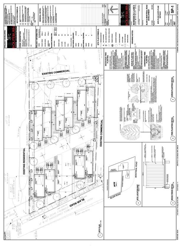
The site is located on the east side of Blair Road, north of Montreal Road. The total area of the site is 2903 square metres with approximately 43 metres of frontage along Blair Road. A single detached dwelling and accessory garage are currently located on the site and will be removed in order to accommodate the proposed development.
Surrounding land uses include residential uses in the form of single detached dwellings to the north, a service garage to the south, commercial and residential uses to the east, and the National Research Council campus to the west.
A rock outcrop is located in the north-east and east portion of the site, with an elevation change of approximately 3.5 metres between the top and bottom of bank. Another rock outcrop results in an elevation change between the rear yards of the abutting residential properties to the north and the site of between 1.3 metres and 4.1 metres (increasing from west to east). The remainder of the site is generally flat. A variety of trees are located on the site and are mainly situated along the perimeter. The property is generally fenced on all sides.
Purpose of Zoning Amendment
A rezoning has been requested in order to accommodate five semi-detached dwellings accessed by an internal private road. The private road will be accessed from Blair Road.
A conceptual plan has been submitted in support of the application. The plan proposes the development of 10 dwelling units, resulting in a density of 34 dwelling units per hectare and a lot coverage of approximately 30 per cent. Parking for each unit is accommodated through garages and surface parking and three visitor parking spaces are provided. The existing water, storm and sanitary sewer infrastructure will provide services to the site.
In order to accommodate the proposal, the applicants have requested a number of site specific exceptions to the Row Dwelling Rr-1 Zone. These exceptions include a decrease in the number of visitor parking spaces and a reduction of the laneway widths.
Existing Zoning
The current Rs-4 zoning permits single dwellings
on lots having a minimum area of 555 square metres and frontage of nine metres.
Under this zone, the site could accommodate the creation of four single
dwelling lots.
Proposed Zoning
The proposed zoning would permit the development of five semi-detached dwellings, for a total of 10 dwelling units, subject to specific development requirements.
DISCUSSION
The site is designated “General Urban Area”. This designation permits the development of a full range and choice of housing types to meet the needs of residents as well as employment, retail, service, cultural, leisure, entertainment and institutional uses. The Official Plan indicates that residential intensification is subject to Section 3.6.1.3 and subsequently Sections 2.5.1 and 4.11. Together, these policies contain criteria to ensure that infill development is compatible with the existing urban fabric. Growth of the City includes intensifying development in the urban area where the use of serviced lands can be maximized and consumption of greenfields are reduced. Infill development requires good design for achieving quality development at higher densities.
Pursuant to the direction of the Official Plan,
the City has developed the Urban Design Guidelines for Low-Medium Density
Infill Housing to support the development of compatible housing designs.
Analysis
The subject site is a gateway to the single detached residential area to the north and a transition area between residential and non-residential uses. This location, although considered part of Rothwell Heights, is also separated, but not isolated, from the other residential uses by the topography and through having frontage on Blair Road. This property is the only site fronting on Blair Road for the block between Montreal Road and Nichol Street, approximately 150 metres north of the site.
Semi-detached dwellings are
appropriate at this location, providing for intensification of the site with an
appropriate change in land use between single detached dwellings and
non-residential uses. Although this introduces a new housing form in the
neighbourhood, semi-detached dwellings provide opportunities for the
development to be at an appropriate and human scale, are compatible with single
detached dwellings and offer landscaping which respects the character of lower
density development. The 10 units which are proposed create a small community. The configuration of the development
makes it possible for the driveways and garage doors to be less visible from
the main road and the single entrance reduces the number of individual driveway
accesses to Blair Road. This also increases the landscaped areas abutting Blair
Road, providing for a higher quality public streetscape.
The proposed infill development provides
a housing option and makes use
of existing serviced lands adjacent to existing infrastructure and
transportation networks. The site is accessible to the downtown core and other
employment areas, namely the National Research Council (NRC) Campus and the
Montreal Road commercial corridor.
There are also commercial amenities within
walking distance along Montreal Road and St. Laurent Shopping Centre is in
proximity. Within the vicinity of the site, there are a number of schools
offering education up to the high school level. Two parks, Quarry Park and
Birdland Park, are within walking distance of this site and contain a number of
active and passive recreation facilities.
The concept plan demonstrates that the development can be appropriately buffered from the adjoining uses. Fencing at a minimum height of two metres will be required where the site abuts a residential use to define the boundary, maintain privacy and mitigate the potential impacts of vehicle headlight glare on the abutting properties. A three-metre landscaping strip along the north property line has been shown to provide a buffer and landscaping opportunity between the proposed and existing developments.
Traffic Considerations
The proposal does not trigger the need for a Transportation Impact Assessment as outlined in the Council approved Transportation Impact Assessment Guidelines. The traffic generated from this site to the adjacent transportation network can be accommodated. The Official Plan classifies Montreal Road and Blair Road (south of Montreal Road) as Arterial roads which are designed to carry large volumes of traffic over long distances, accommodating car, truck, pedestrian, cyclist, and public transit traffic. Blair Road north of Montreal Road is considered a Major Collector and functions to connect communities and distribute traffic between the arterial system and the local road system. Access details will be refined confirmed at the time of site plan control approval.
A Serviceability Report was submitted in support of the proposal. Existing storm, sanitary and watermain services are available within the Blair Road right-of-way. The Report concludes that these services are adequate to service the re-development of the site. Stormwater management will reduce the peak flows to allowable approved levels. Detailed engineering design of the systems will be addressed at site plan approval stage.
On-Site Parking
Under Zoning By-law 333 of 1999, two parking spaces are required for each unit of a semi-detached dwelling, resulting in 20 required parking spaces. The proposal indicates 26 spaces will be provided through a combination of surface and garage parking. The proposed new Zoning By‑law requires one parking space per unit. Under either by-law, therefore, the current proposal provides the required parking.
The former City of Gloucester Zoning By-law requires designated visitor parking at a rate of 20 per cent of the required parking. In its present form, the development would require four visitor parking spaces, creating a deficiency of one space, as only three spaces are provided in the proposed plan. Although the total parking provided is in excess of the required parking, the excess parking benefits only specific units and is not available for visitors of the units which provide only the required number of parking spaces.
Blair Road in this vicinity provides for
traffic on one lane in either direction and must also accommodate a public
transit route. As such, on-street parking should be kept to a minimum as much
as possible. Cars should also not park
on the nearby commercial sites without the prior consent of the landowner.
Accordingly, staff are not recommending a reduction in the number of required
visitor parking spaces. It is noted, however, that the consolidated by-law does
not require visitor parking for semi-detached dwelling developments. Depending
on the timing of the application for site plan approval, it will be required to
comply with the more restrictive provision. In the case of parking, this will
result in the project being required to provide two spaces per unit plus
visitor parking.
Aisle Width
Staff have concluded that the requested
reduction in the aisle width from 7.5 metres to 6.0 metres provides adequate
manoeuvring area. The
reduction in aisle width is intended to apply only to the private road portion
where there are no driveway accesses to the individual dwelling units. The road
widens to 7.5 metres at the access at Blair Road, providing sufficient turning
and sight area. The portion of the private road with access to the driveways is
7.5 metres in width. Fire vehicles are able to maneuver within the area
provided.
The proposed Comprehensive Zoning By-law allows
parallel visitor parking on a private way within a Planned Unit Development,
provided the private way is a minimum width of 8.5 metres. The site plan
indicates a private lane way width of 8.6 metres, consisting of the 6.0 metres
travelled portion and 2.6 metres of parking space width.
Former City of Gloucester Zoning By-law 333 of 1999
Sections 6.2.16.1.6 and 7 require that where there is more than one dwelling on a lot, each parcel is to meet the minimum frontage and lot area of the zone. However, the zone does not specify an appropriate frontage and lot area for semi-detached dwellings and therefore, these have been specified in the site specific zone. Each dwelling unit is to have a minimum lot frontage of 6.5 metres and area of 170 square metres.
Section 6.13.2.6 requires a minimum distance of 5.0 metres between the driving aisle parcel boundary and the dwelling unit. This distance cannot be satisfied for the units on either side of the entrance and it is appropriate to reduce this requirement to 1.4 metres. This reduction in the distance would be between the side of the dwelling units and the driving aisle, rather than the front of the dwelling, where privacy and headlight glare would be more of a concern. Landscaping is indicated in this area and the driving aisle abuts the sides of the dwelling unit, of which a portion is the garage.
Draft Comprehensive Zoning By-law
This development is considered a Planned Unit Development in the draft Comprehensive Zoning By-law and subject to requirements specific to this type of development. The minimum setback of a wall of a residential use building to a private way is reduced from 1.8 metres to 1.4 metres.
Further, the minimum lot width and area requirements are increased to recognize the existing width and area requirements of approximately 40 metres and 2900 square metres respectively for the entire parcel. The maximum building height is also reduced from the general residential height of 11 metres to 10.7 metres. The minimum rear yard required is 6.0 metres and the interior side yard of 3.0 metres is required abutting the north lot line and 1.4 metres abutting the south property line.
Further Approvals
Development of the site is subject to further
review through the Site Plan Control approval process. At that time, a Noise
Study, Geotechnical Report, Serviceability Report, site plan, landscaping plan
and engineering plans will be required. As comments were received from the
public regarding concerns of shadowing on their properties, a Shadowing Study
will also be required. Any recommendations of the reports are to be implemented
through the Site Plan approval.
Conclusion
Staff recommend a modified zone with limits on the site development to minimize the potential for impacts on neighbours while meeting the objectives of the Official Plan. The proposed zoning allows for denser development, but also requires adequate landscaping and buffering to mitigate negative impacts with the existing development.
ENVIRONMENTAL IMPLICATIONS
A Phase II Environmental Site Assessment was prepared in support of the application. The Assessment was to address any potential impact on the site as a result of the use on the adjacent property located at 1649 Montreal Road (immediately south of the subject site) as a service garage and historical use as a retail fuel outlet/service garage. Both soil and water samples were analysed and it was concluded that the adjacent use did not appear to have impacted the soil or groundwater of the subject site. It was also concluded that no further environmental investigation or site remediation program is required at this time.
CONSULTATION
Notice of this application was carried out in accordance with the City's Public Notification and Consultation Policy. Approximately 15 written submissions were made expressing concern that the proposal was not in keeping with the character of the area, the proposed density was too high, lack of buffer with the residential uses, insufficient visitor parking, the impact of increase in traffic on the road network and loss of privacy. The public consultation session held on February 28, 2008 reiterated these concerns. A summary and discussion of the concerns is provided in Document 3.
The Ward Councillor is aware of this application and the staff recommendation.
FINANCIAL IMPLICATIONS
APPLICATION PROCESS
TIMELINE STATUS
The application was not processed by the "On
Time Decision Date" established for the processing of Zoning By-law
amendments due to the complexity of the issues associated with the
compatibility of the proposal and the need for a Community Information and
Comment Session.
SUPPORTING DOCUMENTATION
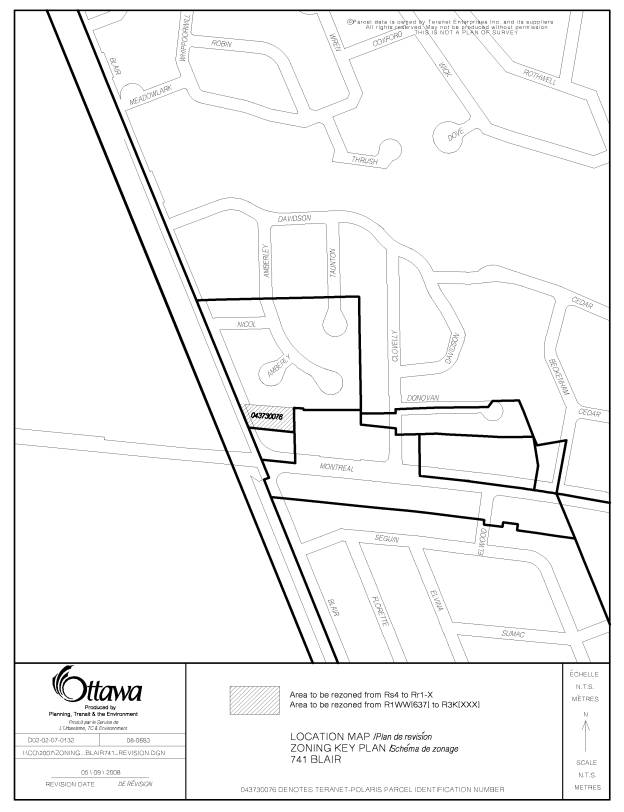
Document 1 Location Map
Document 2 Details
of Recommended Zoning
Document 3 Consultation Details
Document 4 Preliminary site plan
DISPOSITION
City Clerk’s Branch, Council and Committee
Services to notify the owner (Bill Metz, Routeburn Blair Corp., 446 Cloverdale
Road, Ottawa, ON K1M 0Y6), applicant
(Lloyd Phillips, Lloyd Phillips & Associates Ltd., 1501 Carling Avenue, Suite
200, Ottawa, ON K1Z 7M1), OttawaScene.com, 174 Colonnade Road, Unit #33, Ottawa, ON K2E 7J5,
Ghislain Lamarche, Program Manager, Assessment, Financial Services Branch (Mail
Code: 26-76) of City Council’s
decision.
Planning, Transit and the Environment
Department to prepare the implementing by-law, forward to Legal Services Branch
and undertake the statutory notification.
Legal Services Branch to forward the
implementing by-law to City Council.
LOCATION MAP DOCUMENT
1
DETAILS OF RECOMMENDED ZONING DOCUMENT
2
A. Former City of Gloucester Zoning By-law, By-law No. 333 of 1999
1. Map 1C of the Gloucester Zoning By-law will be amended by changing the zoning for 741 Blair Road from Residential, Single Dwelling (“Rs4”) to Row Dwelling Zone Exception (X) (“Rr1(EX)”) as shown on Document 1.
2. A new exception, number X, will be added to Section 6.18-Exceptions to Urban Residential Zones to include the following special provision:
Despite any provision in this By-law to the contrary, on lands zoned Rr1(EX) the following exceptions apply:
1) Despite Section 6.13.1, the only permitted main uses are private semi-detached dwelling and single dwelling
2) Maximum net residential density: 34 dwelling units per hectare
3) Despite Section 6.13.2.6, building line requirement for dwelling to driving aisle parcel boundary is 1.4 metres
4) Despite Section 3.17.1, a driving aisle a minimum of 6.0 metres in width must be provided where it is the private road and there is no driveway access to a dwelling unit
5) Despite Section 6.2.16.1.6, where more than one private semi-detached dwelling is developed on a lot, each exclusive use residential parcel must have a minimum parcel frontage of 6.5 metres.
6) Despite Section 6.2.16.1.7, where more than one private semi-detached dwelling is developed on a lot, each exclusive use residential parcel must have a minimum area of 170 square metres.
B. Proposed Comprehensive City of Ottawa Zoning By-law
1. The zoning map of the Comprehensive City of Ottawa Zoning By-law will be amended by changing the zoning for 741 Blair Road from Residential First Density Zone, Exception 637, R1WW[637] to Residential Third Density Zone, Subzone K, Exception [xxx], R3K[xxx] as shown on Document 1.
2. A new exception will be added to Section 239-Exceptions to include the following special provisions:
1) Despite Table 131(2), the minimum setback for any wall of a residential use building to a private way is 1.4 metres
2) Only permitted principal dwelling types are: Planned Unit Development, detached dwelling, semi-detached dwelling
3) Maximum number of dwelling units: 10
4) Minimum lot width: 40 metres
5) Minimum lot area: 2900 square metres
6) Maximum building height: 10.7 metres
7) Minimum front yard: 6.0 metres
8) Minimum rear yard: 6.0 metres
9) Minimum interior side yard abutting a residential use or zone: 3.0 metres
10) Minimum interior side yard abutting any other zone: 1.4 metres
CONSULTATION DETAILS DOCUMENT
3
NOTIFICATION AND CONSULTATION
PROCESS
Notification and public consultation
was undertaken in accordance with the Public Notification and Public
Consultation Policy approved by City Council for Zoning By-law amendments.
PUBLIC COMMENTS
Public consultation consisted of a Community Information and Comment Session on February 28, 2008. Approximately 32 residents attended.
SUMMARY OF PUBLIC INPUT
The following concerns were expressed both through the written submissions and at the Community Information and Comment Session:
1) The number of units proposed causes the development to be too dense.
2) The proposed setbacks and fencing are inadequate to buffer the development from the existing residential uses.
3) The proposed visitor parking is insufficient, causing concerns that this will result in parking on the local streets or on the adjacent commercial property.
4) On-site snow storage area is insufficient.
5) Concerns were raised regarding the amount of excavation which may be required to develop the property, impact of blasting, hammer drilling and digging and the resulting potential damage to adjoining properties during construction.
6) Questions were raised regarding the height of buildings and elevation as seen from the north side of the property and the resulting impact on the residential properties and their privacy. Further, there was concern regarding the increase in noise and traffic from the development on the existing residential area.
7) Concerns were raised regarding the traffic impact of the proposal on Blair Road and the ability of the existing intersection at Blair and Montreal Roads to accommodate the increase in traffic. Pedestrian safety was also raised as a concern.
8) Comments were made that the proposal is not in keeping with the character of or compatible with the area and its location at the entrance to Rothwell Heights.
9) Lack of integration of the development in the ‘park-like’ setting of the area and the general lack of trees/vegetation proposed.
10) Information was requested concerning the location of outside storage and collection of garbage/recycling.
RESPONSE TO PUBLIC INPUT
1) to 4) Concerns expressed by the community regarding density, buffering and parking are addressed in the discussions in the main report. Snow will be required to be removed from the site as a condition of site plan approval.
5) The site plan control agreement will address site specific construction issues.
6) It has been indicated that the buildings would be up to three storeys in height, to a maximum of 10.7 metres. It is expected that the north-east units will have walkouts at the rear to respect the rock outcrop, and therefore will give the appearance of a two or one and a half storey structure from the north-east and east. A height limit of 10.7 metres is appropriate, as it reflects the typical height limit within a residential zone. The grade change provides a natural buffer and given that this site is lower than the surrounding residential uses, the proposed structures will have the appearance of a two-storey building from the north, but three from the road.
Through the design and the strategic placement of doors, the intention is to provide the appearance of a single detached dwelling along Blair Road, to be more in character with the existing single detached dwellings in the community. Walkways are provided linking the entrances to the sidewalk on Blair Road, providing a relationship between the private space and public space. This area is also proposed to be landscaped, softening the transition between the street and the residential development, enhancing the entrance into the community and providing amenity space for the residents.
The design of the roof will be reviewed during site plan control.
7)
The
proposal does not trigger the need for a Transportation Impact Assessment. An
assessment is required where greater than 75 vehicles per hour (peak hour,
two-direction site generated trips) is expected to be generated as a result of
a proposal. Traffic signals are currently located at the intersection of Blair
and Montreal Roads. Based on the traffic counts at Montreal and Blair Roads,
the Level of Service during the peak period is B and at other times at A. Given the size of this development, impact
to Level of Service will be negligible.
Sidewalks are provided on both Blair Road and Montreal Road.
8) It has been indicated that the buildings will be designed to appear as a single detached dwelling and are to be reviewed in greater detail at the site plan control stage. The massing of the buildings is reduced by the staggering of the units which visually breaks up a wall into smaller sections.
9) The landscaping plan is to be reviewed as site plan control stage. A fence with a minimum height of two metres is to be provided where it abuts a residential use.
10) The location, design and landscaping of garbage/recycling storage space to be reviewed at site plan control stage. Concrete pads have been requested at the entrance, to allow for municipal collection.
COMMUNITY ORGANIZATION COMMENTS
Rothwell Heights Property Owner’s Association
The Association has taken the view that development on this site may be suitable subject to the conditions: that the total number of residential units is restricted to six, the front and side setbacks are increased from those shown on the initial proposal and a substantial landscaped buffer is provided within the side and front yards.
Subsequently, in response to the revised plan, the Association supported the increase in side yard setback, but raised questions whether landscaping can occur because of the prevalence of surface rock. They also indicated that there was insufficient information on trees or their protection and that the visitor parking and driveway width should comply with the by-law requirements.
PRELIMINARY SITE PLAN DOCUMENT
4