|
2. zONING - 6911 through 6950
Mary Anne Drive, 6735 through zONAGE - Du 6911 au 6950, promenade Mary Anne, du 6735 |
Committee
Recommendations
That Council:
1.
Approve an
amendment to the former Township of Osgoode Zoning By-law to alter the
provisions of the R(246), R(247) and R(248) zones which apply to 6911 through
6950 Mary Anne Drive, 6735 through 6850 Breanna Cardill Street and
1640 through 1664 Curly Lane as shown in Document 1 and as detailed in
Document 2.
2. Approve an amendment to the new Comprehensive Zoning By-law to alter the provisions of the V1I(610r), V2D(612r) and V3G(612r) zones which apply to 6911 through 6950 Mary Anne Drive, 6735 through 6850 Breanna Cardill Street and 1640 through 1664 Curly Lane as shown in Document 1 and as detailed in Document 2.
Recommandations
du comité
Que le Conseil :
1. approuve une modification au
Règlement de zonage de l'ancien Canton de Osgoode, de manière à changer les
dispositions des zones R(246), R(247) et R(248) s'appliquant aux 6911 à 6950,
promenade Mary Anne, aux 6735 à 6850, rue Breanna Cardill et aux 1640 à
1664, allée Curly, tel qu'illustré dans le Document 1 et exposé en détail dans
le Document 2.
2. approuve une modification au nouveau Règlement de zonage général,
de manière à changer les dispositions des zones V1I(610r), V2D(612r) et
V3G(612r) s’appliquant aux 6911 à 6950, promenade Mary Anne, aux 6735 à
6850, rue Breanna Cardill et aux 1640 à 1664, allée Curly, tel qu’illustré
dans le Document 1 et exposé en détail dans le Document 2.
Documentation
1. Deputy City Manager's report (Planning,
Transit and the Environment) dated
15 April 2008 (ACS2008-PTE-PLA-0085).
Report to/Rapport au :
Agriculture and Rural Affairs Committee
Comité d'agriculture et des questions rurales
and Council / et au Conseil
Submitted by/Soumis par : Nancy Schepers, Deputy City Manager/
Directrice municipale adjointe,
Planning, Transit and the Environment/
Urbanisme, Transport en commun et Environnement
Contact Person/Personne ressource : Karen Currie,
Manager / Gestionnaire, Development Approvals / Approbation des demandes
d'aménagement
(613) 580-2424, 28310 Karen.Currie@ottawa.ca
REPORT RECOMMENDATIONS
That the Agriculture and Rural Affairs Committee recommend Council:
1. Approve
an amendment to the former Township of Osgoode Zoning By-law to alter the
provisions of the R(246), R(247) and R(248) zones which apply to 6911 through
6950 Mary Anne Drive, 6735 through 6850 Breanna Cardill Street and
1640 through 1664 Curly Lane as shown in Document 1 and as detailed in
Document 2.
2. Approve an amendment to the new
Comprehensive Zoning By-law to alter the provisions of the V1I(610r), V2D(612r)
and V3G(612r) zones which apply to 6911 through 6950 Mary Anne Drive, 6735
through 6850 Breanna Cardill Street and 1640 through 1664 Curly Lane as
shown in Document 1 and as detailed in Document 2.
RECOMMANDATIONS DU RAPPORT
Que le Comité de l’agriculture et des
questions rurales recommande au Conseil :
1. d'approuver une
modification au Règlement de zonage de l'ancien Canton de Osgoode, de manière à
changer les dispositions des zones R(246), R(247) et R(248) s'appliquant aux
6911 à 6950, promenade Mary Anne, aux 6735 à 6850, rue Breanna Cardill et
aux 1640 à 1664, allée Curly, tel qu'illustré dans le Document 1 et exposé en
détail dans le Document 2.
2. d’approuver
une modification au nouveau Règlement de zonage général, de manière à changer
les dispositions des zones V1I(610r), V2D(612r) et V3G(612r) s’appliquant aux
6911 à 6950, promenade Mary Anne, aux 6735 à 6850, rue Breanna Cardill et
aux 1640 à 1664, allée Curly, tel qu’illustré dans le Document 1 et exposé
en détail dans le Document 2.
BACKGROUND
The site is located on the west side of Old Prescott Road south of Donwell Drive in the south end of the Village of Greely. It consists of properties within a registered subdivision that front on Mary Anne Drive, Breanna Cardill Street and Curly Lane.
This development, known as
Shadowridge, was approved on the basis of a municipally owned and operated
communal well and sewage disposal system.
Phase one of the subdivision was registered in 2007 and the communal systems
are pending commissioning, that will allow for building permits to be issued.
The subdivision is developing with a few model homes under construction. The existing residential exception zones for the development have smaller lot areas, frontages and setbacks than the typical Residential Zone.
Purpose of
Zoning Amendment
The lot coverage maximum of 15 percent was not changed when the original exception zones were introduced on the property. The zones did not reflect the reduction in lot sizes and setbacks from the standard Residential Zone. As a result, the single, semi-detached and row dwelling models cannot be built in compliance with the maximum lot coverage. The row dwellings are proposed to be carriage homes - a wider unit type and need to be closer to the interior and exterior side lot lines to reflect that built form.
Zoning
The existing zones in the former Township of Osgoode Zoning By-law are:
1) R(246) - Residential exception 246 for the singles along Mary Anne Drive;
2) R(247) - Residential exception 247 for the semi-detached dwellings on Curly Lane and the west side of Breanna Cardill Street, and
3) R(248) - Residential exception 248 for the row dwellings on Breanna Cardill Street
The proposed new Comprehensive Zoning By-law zones the lands:
1)
V1I(610r) - Village Residential First Density 610 rural
for the singles. It has a 15 per
cent maximum lot coverage;
2) V2D(611r) - Village Residential Second Density 611 rural for the semi-detached dwellings. It has a 40 per cent maximum lot coverage and an unspecified holding provision on the Zoning Map, and
3) V3G(612r) - Village Residential Third Density 612 rural for the row dwellings. It has no maximum lot coverage and an unspecified holding provision on the Zoning Map.
Osgoode Zoning By-law
1) To increase the maximum lot coverage for each exception zone to permit the construction of singles, semi-detached and row dwellings, within each respective zone.
2) To reduce side yard setbacks in the R(248) zone (for row dwellings) from 10.0 to 7.0 metres for the exterior side yard and from five to three metres for the interior side yard.
New Comprehensive Zoning By-law
It is anticipated that the draft
New Comprehensive Zoning By-law will be passed by City Council in the near
future. With this in mind, it is
recommended that the appropriate changes to the relevant zoning provisions in
the new by-law be made as soon as possible after the new by‑law has been
passed.
1) To increase the lot coverage in the V1I(610r) zone to 30 per cent.
2) To reduce the V3G(612r) zone minimum sideyard setbacks from 5.0 to 3.0 metres for the interior side yard and from 10.0 to 7.0 metres for the corner side yard setbacks.
3) The ‘- h’ shown on the Draft Zoning By-law for the V2D(612r) and the V3G(612r) zones on the subject lands should be removed from the Zoning Map.
DISCUSSION
The Official Plan designates the
site as being in the Village of Greely.
The Village of Greely Community Design Plan applies to these lands. That
plan identifies this subdivision as Residential and in addition permits
semi-detached and row dwellings.
When the original zoning for this development
was approved information on the units was not available. Exception zones were created for the
proposed single-family homes, semi-detached homes and row dwellings. There was an attempt to create zones
compatible with a Village setting, but with higher density to make the communal
servicing cost effective. In doing so,
the lot areas and frontages were reduced, and the setbacks altered
slightly. The lot coverage maximum of
15 percent was not changed.
The proposed single family and semi-detached
homes would exceed the coverage, but would comply with the setbacks in the
existing zoning. The row dwellings proposed
are carriage homes. Access to the rear yards would be through each unit’s
garage and not via the typical access easement through the adjacent
properties. This results in a wider
unit and the need to reduce the side yard requirements to implement this. The carriage homes would also exceed the
maximum lot coverage.
Although the requested zone change by the
applicant did not have a lot coverage maximum, staff consider it appropriate to
apply a maximum as this is still a Village setting and it is important that
this development fit with the existing residential development. The proposed coverages are listed in
Document 2. The development will still
be consistent with the original setbacks and village feel of Greely. Staff supports the recommended zoning
changes to reduce side yards for the row dwellings and to implement a more
generous maximum lot coverage for all three housing forms. The recommended changes to the Draft Zoning
By-law are consistent with the recommended changes to the Osgoode Zoning
By-law.
RURAL IMPLICATIONS
This Zoning By-law amendment will allow for additional housing forms to be built within a village while still being compatible with the village setting.
CONSULTATION
Notice of this application was carried out in accordance with the City's Public Notification and Consultation Policy. The Ward Councillor is aware of this application and the staff recommendation. The City did not receive any negative comments or opposition to this application.
FINANCIAL IMPLICATIONS
APPLICATION PROCESS
TIMELINE STATUS
This application was processed by the "On Time
Decision Date" established for the processing of Zoning By-law amendment
applications.
SUPPORTING DOCUMENTATION
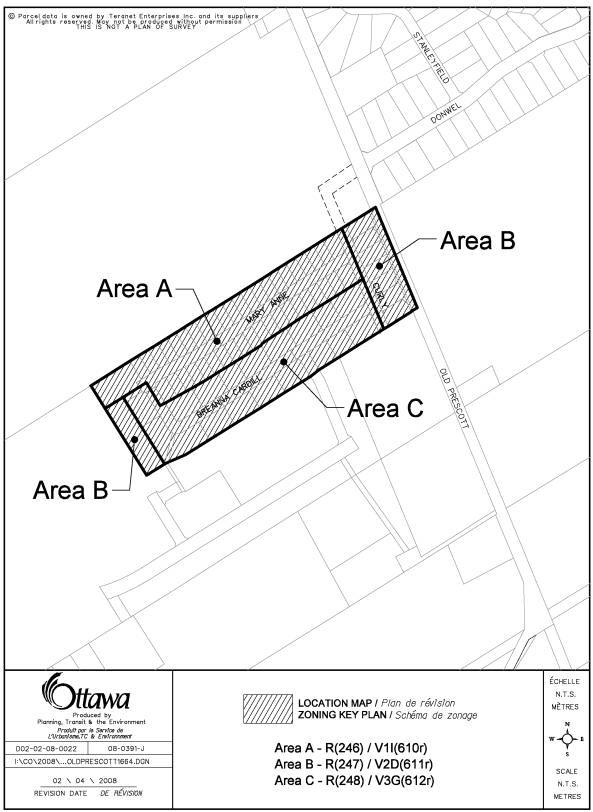
Document 1 Location Map
Document 2 Details
of Recommended Zoning
DISPOSITION
City Clerk’s Branch, Council and Committee
Services to notify the owner, Don Cardill Donwel Land Inc. 7015 Quinfield Way
Greely ON K4P 1N6, applicant, Paul Skvor DCR/Phoenix Group 18 Bentley Ave Nepean
ON K2E 6T8, OttawaScene.com, 174 Colonnade Road, Unit #33, Ottawa, ON K2E 7J5,
Ghislain Lamarche, Program Manager, Assessment, Financial Services Branch (Mail
Code: 26-76) of City Council’s
decision.
Planning, Transit and the Environment
Department to prepare the implementing by-law, forward to Legal Services Branch
and undertake the statutory notification.
Legal Services Branch to forward the implementing
by-law to City Council.
DOCUMENT 1
LOCATION MAP
DOCUMENT 2
DETAILS OF RECOMMENDED ZONING
1) The lands shown as Area A on Document 1 zoned
R(246) under By-law 2003-230 will be subject to the following text change to
the exception:
‘- maximum lot coverage shall be 30 per cent’
2) The lands shown as Area B on Document 1 zoned
R(247) under By-law 2003-230 will be subject to the following text change to
the exception:
‘- maximum lot coverage shall be 35 per cent’
3) The lands shown as Area C on Document 1 zoned
R(248) under By-law 2003-230 will be subject to the following text change to
the exception:
a) Removing the following clauses under Column IV
‘- minimum interior side yard of 5.0 metres
- minimum exterior side yard of 10.0 metres’
b) Adding the following clause under Column IV:
‘- maximum lot coverage shall be 40 per cent
- minimum interior side yard of 3.0 metres
- minimum exterior side yard of 7.0 metres’
4) The lands shown as Area A on Document 1 zoned
V1I(610r) under the new Comprehensive Zoning By-law will be subject to the
following text change to the exception:
‘- maximum lot coverage shall be 30 per cent.’’
5) The lands shown as Area C on Document 1 zoned
V3G(612r) under the new Comprehensive Zoning By-law will be subject to the
following text change to the exception:
‘- minimum interior side yard setback of three metres
- minimum corner side yard setback of seven metres’
6) The lands shown as Area B on Document 1 zoned V2D(611r) and Area C on Document 1 zoned V3G(612r) under the new Comprehensive Zoning By-law will be have the ‘- h’ removed from the Zoning Map.