|
3. ZONING – 400 PAUL METIVIER
DRIVE ZONAGE - 400, PROMENADE
PAUL METIVIER |
Committee recommendation as amended
(This matter is subject to Bill
51)
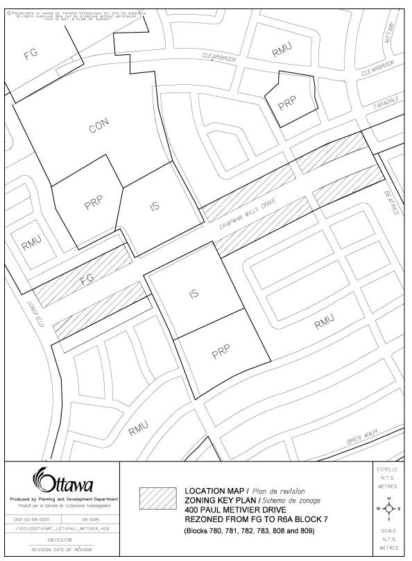
That Council approve an
amendment to the former City of Nepean Zoning By-law to change the zoning of portions
of the lands described as 400 Paul Metivier Drive from Future Growth - FG to
Residential Sixth “A” Density Exception Zone - R6A Block 7 as shown in Document
1, as amended.
Recommandation modifiÉe du Comité
(Cette question est assujettie au Règlement 51)
Que le Conseil approuve une modification au Règlement de zonage de
l'ancienne Ville de Nepean, de manière à faire passer le zonage des parties du
terrain décrit comme étant le 400, promenade Paul Metivier de Croissance future
- FG à zone résidentielle d'exception de sixième densité « A » - R6A îlot 7, tel
que modifié.
Documentation
1.
Deputy
City Manager's report Planning, Transit
and the Environment dated 20 March 2008 (ACS2008-PTE-PLA-0073).
2. Extract
of Draft Minutes, 22 April 2008.
Report to/Rapport au :
Planning and Environment Committee
Comité de l'urbanisme et de l'environnement
and Council / et au Conseil
20 March 2008 / le 20 mars 2008
Submitted by/Soumis par : Nancy Schepers, Deputy City Manager
Directrice municipale adjointe,
Planning, Transit and the Environment
Urbanisme, Transport en commun et Environnement
Contact Person/Personne ressource : Karen Currie,
Manager / Gestionnaire, Development Approvals / Approbation des demandes
d'aménagement
(613) 580-2424, 28310 Karen.Currie@ottawa.ca
|
SUBJECT: |
|
|
|
|
|
OBJET : |
REPORT RECOMMENDATION
That the Planning and
Environment Committee recommend Council approve an amendment to the former City
of Nepean Zoning By-law to change the zoning of portions of the lands described
as 400 Paul Metivier Drive from Future Growth - FG and Residential Mixed Unit Zone - RMU to Residential Sixth “A”
Density Exception Zone - R6A Block 7 as shown in Document 1.
RECOMMANDATION DU RAPPORT
Que le Comité de l'urbanisme et de l'environnement
recommande au Conseil d'approuver une modification au Règlement de zonage de
l'ancienne Ville de Nepean, de manière à faire passer le zonage des parties du
terrain décrit comme étant le 400, promenade Paul Metivier de Croissance future
- FG et zone résidentielle mixte - RMU à zone résidentielle d'exception de
sixième densité « A » - R6A îlot 7, tel qu'illustré dans le Document 1.
BACKGROUND
The
lands subject to this application are located at 400 Paul Metivier Drive within
the Chapman Mills Development on the west side of Woodroffe Avenue, south of
Strandherd Drive.
The
lands are vacant and total approximately 3.9 hectares. Surrounding lands are
vacant and subject to plans of subdivision for predominantly low to medium
density residential development. The
application is to permit the development of terraced townhouse units that will
contain main floor residential units with the option for accommodating business
office uses within the units.
DISCUSSION
Official
Plan
The
Official Plan designates the property as General Urban Area, which permits a
wide range of uses including the residential use proposed. The site also lies
within a detailed planning area, identified as Areas 4,5 and 6 in the Secondary
Plan for the former City of Nepean. This Secondary Plan designates the site as
a “Mixed Use” area.
Details
of Proposed Zoning
The
existing zoning has two components. Most of the subject lands are zoned Future
Growth - FG, which permits detached dwellings. A portion of the lands, near
the southeast corner of Longfields and Chapman Mills Drive, is zoned
Residential Mixed Unit Zone – RMU, which permits a range of single,
semi-detached and townhouses units.
The
proposed zoning is Residential Sixth “A” Density Exception Zone - R6A Block 7,
permitting stacked units, terraced units and apartments, including Business
Offices, Medical and Dental Offices, Retail Uses and Service
Establishments. The exception allows
for a a variation in setbacks, coverage
and parking. As well, the exception adds the proposed office and retail uses,
which are not permitted in the parent R6A zone.
The
proposed units front onto Chapman Mills Drive which is the
"Mainstreet" of the South Urban Community. The focus of this street
is for a broad mix of higher intensity land uses and to provide the spine of
the future transit network. The “Mixed Use” designation is intended to permit
medium and high-density residential development, in combination with community
level retail and office related development.
The
Secondary Plan for Areas 4, 5, and 6 has been developed based on design
standards that establish guidelines for the type of development that will front
onto Chapman Mills Drive and a road pattern and network that will foster a
vibrant South Urban Town Centre. The
reduced front yard setback of two metres and rear yard setback of 7.5 metres,
including the increased lot coverage of 35 per cent, are all in keeping with a
key objective of the Secondary Plan to bring buildings closer to the street.
The
development of medium density residential uses, and multi-storey buildings
ranging from two up to four storeys along Chapman Mills Drive is consistent
with the Urban Design Policies of the Secondary Plan. Staff is currently
processing a site plan application for these units that front directly on
Chapman Mills Drive with laneways at the rear to service the units.
Staff
recommends approval of this rezoning proposal based on the above-noted
considerations. This development supports the “Mainstreet” density and urban
design policies of both the Official Plan and Secondary Plan for Areas 4,5, and
6.
CONSULTATION
Notice
of this application was carried out in accordance with the City’s Public
Notification and Consultation Policy. The Ward Councillor is aware of this
application and the staff recommendation. The City has not received any
opposition to this application from the public circulation.
FINANCIAL IMPLICATIONS
APPLICATION PROCESS
TIMELINE STATUS
This application was processed by the "On Time
Decision Date" established for the processing of Zoning By-law amendment
applications.
SUPPORTING DOCUMENTATION
Document 1 Location Map
DISPOSITION
City Clerk’s Branch, Council and Committee
Services to notify the owner, Doug Smeathers, South Nepean Development
Corporation, 427 Laurier Ave. West, Suite 300, Ottawa. ON. K1R 7Y2, OttawaScene.com, 174 Colonnade Road, Unit #33, Ottawa, ON K2E 7J5,
Ghislain Lamarche, Program Manager, Assessment, Financial Services Branch (Mail
Code: 26-76) of City Council’s
decision.
Planning, Transit and the Environment
Department to prepare the implementing by-law, forward to Legal Services Branch
and undertake the statutory notification.
Legal Services Branch to forward the
implementing by-law to City Council.
LOCATION MAP REVISED
DOCUMENT 1