|
1.
ZONING - 1370 MURPHY SIDE
ROAD ZONAGE -
1370, CHEMIN MURPHY SIDE |
Committee recommendation
(This application is subject to Bill
51)
That Council approve an amendment to the former City of Kanata Zoning
By-law to change the zoning of 1370 Murphy Side Road from Agriculture (AGR) to
Rural Residential - special exception (RR-XX) as shown in Document 1 and
detailed in Document 2.
Recommandation dU ComitÉ
(Cette demande est assujettie au projet de loi 51)
Que le Conseil approuve une modification au Règlement de zonage de l’ancienne Ville de Kanata afin de changer la désignation de zonage du 1370, chemin Murphy Side de zone agricole (AGR) à zone rurale résidentielle – exception spéciale (RR-XX), tel qu’il est indiqué dans le Document 1 et expliqué en détail dans le Document 2.
Documentation
1.
Deputy City Manager, Planning, Transit and the
Environment report dated 25 September 2007
(ACS2007-PTE-APR-0128)
Report to/Rapport au :
Agriculture and Rural Affairs
Committee
Comité d'agriculture et des questions
rurales
and Council / et au Conseil
25 September 2007 / le 25 septembre 2007
Submitted by/Soumis par : Nancy Schepers, Deputy City Manager / Directrice
municipale adjointe,
Planning, Transit and the Environment /
Urbanisme, Transport en commun et Environnement
Contact Person/Personne
Ressource : Grant Lindsay, Manager / Gestionnaire, Development Approvals /
Approbation des demandes d'aménagement
(613) 580-2424, 13242 Grant.Lindsay@ottawa.ca
|
SUBJECT: |
|
|
|
|
|
OBJET : |
REPORT RECOMMENDATION
That the Agriculture and Rural Affairs Committee recommend Council approve an amendment to the former City of Kanata Zoning By-law to change the zoning of 1370 Murphy Side Road from Agriculture (AGR) to Rural Residential - special exception (RR-XX) as shown in Document 1 and detailed in Document 2.
RECOMMANDATION DU RAPPORT
Que le Comité de l’agriculture et des affaires
rurales recommande au Conseil d’approuver une modification au Règlement de
zonage de l’ancienne Ville de Kanata afin de changer la désignation de zonage
du 1370, chemin Murphy Side de zone agricole (AGR) à zone rurale résidentielle
– exception spéciale (RR-XX), tel qu’il est indiqué dans le Document 1 et
expliqué en détail dans le Document 2.
BACKGROUND
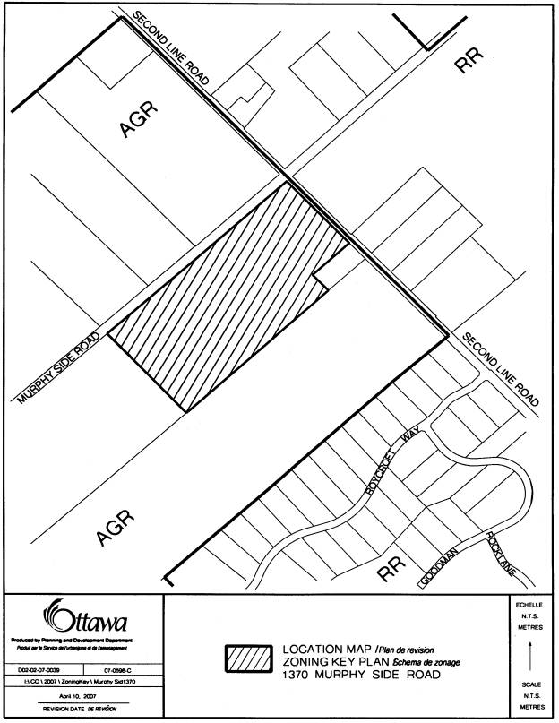
The subject property, 1370 Murphy Side Road, is shown in Document 1. The site is located on the west side of Second Line Road and is south of Murphy Side Road. There are farm fields north of Murphy Side Road and east of Second Line Road, however there is extensive country lot development half a concession width south and southeast of the property. The lands are currently vacant and cleared of vegetation.
An existing unnamed creek traverses the property and flows from the south to the north. Consideration must be made for the protection of this watercourse.
Draft Plan approval for a 21-lot subdivision was granted for this property on March 29, 2007.
Purpose of
Zoning Amendment
The purpose of this Zoning By-law amendment is to rezone the subject lands consistent with the recent draft plan approval for a country lot subdivision and to protect the watercourse.
The subject property is currently zoned ‘AGR’ (Agriculture). The Agriculture zone permits single-detached dwellings but only on lots large enough to support an agricultural type of activity or land uses that do not conflict and are compatible with the agricultural function of the area such as animal hospitals, kennels and catteries.
The applicant is proposing to rezone the lands ‘RR-XX’ (Rural Residential – special exception). The special exception is for the establishment of some zone requirements that are different from those of the Rural Residential zone. For instance, the minimum lot area would decrease from 0.81 hectares to 0.8 hectares and the minimum lot frontage would be reduced from 60 metres to 40 metres for all of the lots. A 35-metre-wide corridor is also being established by implementing a setback of 15 metres on each side of the creek from the normal highwater mark.
DISCUSSION
The lands are designated General Rural Area.
Residential uses in the form of country lot subdivisions are permitted in this
designation. The General Rural Area
policies outline the criteria against which country lot subdivisions are
evaluated. This proposal meets those
criteria.
The
applicant is proposing to rezone the property from AGR (Agriculture) to RR-XX
(Rural Residential – special exception). The Rural Residential zone is an
appropriate use for lands within the General Rural designation of the Official
Plan.
Staff is recommending that Schedule “A”, of By-law 74-79 of the former
City of Kanata be amended to create the proposed zone.
ENVIRONMENTAL IMPLICATIONS
The watercourse that traverses through the site as well as the fish habitat that accompanies it will be protected. The provision of a 15-metre setback from the existing top of bank offers sufficient protection and meets the minimum setback requirement identified in the Official Plan. A culvert crossing that will be required as part of the development of these lands may have an impact on the watercourse. The culvert design will be reviewed as part of the subdivision requirements prior to the registration of the Plan.
RURAL IMPLICATIONS
This area of rural Kanata has a number of country lot subdivisions in near proximity to the subject lands. An additional 21-lot subdivision at this location is considered a compatible use with the surrounding area.
CONSULTATION
Notice of this application was
carried out in accordance with the City's Public Notification and Consultation
Policy. Consultation details are noted
in Document 3. The Ward Councillor is
aware of this application and the staff recommendation.
FINANCIAL IMPLICATIONS
N/A
APPLICATION PROCESS
TIMELINE STATUS
The application was not processed by the
"On Time Decision Date" established for the processing of Zoning
By-law amendments due to the time required by the Mississippi Valley
Conservation Authority and the applicant to determine the most appropriate
means of dealing with the watercourse found on site.
SUPPORTING DOCUMENTATION
Document 1 Location Map
Document 2 Details
of Recommended Zoning
Document 3 Consultation Details
DISPOSITION
City Clerk’s Branch, Council and Committee
Services to notify the owner, Mr. Zbigniew Hauderowicz, 113 James Cummings
Avenue, Ottawa, Ontario, K2H 8E3, applicant, Mr. Bill Holzman, President, Holzman Consultants
Inc. 1076 Castle Hill Crescent, Ottawa, Ontario, K2C 2A8, OttawaScene.com, 174 Colonnade Road, Unit #33, Ottawa,
ON K2E 7J5,
Ghislain Lamarche, Program Manager, Assessment, Financial Services Branch (Mail
Code: 26-76) of City Council’s
decision.
Planning, Transit and the Environment
Department to prepare the implementing by-law, forward to Legal Services Branch
and undertake the statutory notification.
Legal Services Branch to forward the
implementing by-law to City Council.
LOCATION MAP DOCUMENT
1
DETAILS OF RECOMMENDED ZONING DOCUMENT
2
Schedule A of By-law Number 74-79 will be revised to show the subject lands will be rezoned from Agricultural Resource (AGR) to Rural Residential – special exception (RR-XX) as illustrated in Document 2. The following applies:
RR-XX:
· Lot Area New Lot (minimum): 0.8 ha
· Lot Frontage New Lot (minimum): 40 metres
· Lot Area Remaining Lot (minimum): does not apply
· Lot Frontage Remaining Lot (minimum): does not apply
· No construction is permitted within 15 metres of the normal highwater mark on each side of the creek as defined by the Mississippi Valley Conservation Authority
CONSULTATION DETAILS DOCUMENT
3
NOTIFICATION AND CONSULTATION PROCESS
Notification and public consultation
was undertaken in accordance with the Public Notification and Public
Consultation Policy approved by City Council for Zoning By-law amendments.
ADVISORY COMMITTEE COMMENTS
The Greenspace Alliance of Canada’s Capital objects to any rezoning of agricultural land as we cannot afford to lose such lands.
Response:
The existing zoning implemented the old City of Kanata Official Plan policies. This historical document designated the lands as Agricultural Resource. This designation was also established in the Official Plan of the Regional Municipality of Ottawa-Carleton (RMOC).
However, in 1997, the RMOC undertook a comprehensive review of their Official Plan and many designations were changed as a result of this review. The subject lands were redesignated from Agricultural Resource to General Rural Area. These designations were then carried forward into the City of Ottawa’s Official Plan following amalgamation. Once the new Official Plan for the City of Ottawa was adopted, the previous RMOC Official Plan as well as all the local Official Plans were repealed.