REPORT
TO COMMITTEE(S) OF COUNCIL
INTERNAL
ROUTING CHECKLIST
|
|
|
|
|
|
|
|
|
|
|
|
|
|
|
APPLICANT:
APPLICANT’S ADDRESS:
WARD:
Gloucester-Southgate (10)
|
|
||||
|
|
|||||
|
|
|||||
|
|
|||||
|
|
|||||
|
|
|||||
|
|
|
||||
|
|
|||||
|
|
|||||
|
|
|||||
|
|
|||||
|
|
|||||
|
|
|
||||
|
|
|
||||
|
|
||||
|
|
|
||||
|
|
|
||||
|
|
|
|
|||
|
|
|
|
|
||
|
|
|
|
|
||
|
|
|
|
|
||
|
|
|
|
|
||
|
|
|
|
|
||
|
|
|
|
|
||
|
|
|
|
|
||
|
3. Technical Evaluation of Albion Road at
Lester Road THROUGH Movements PROHIBITIONS ÉVALUATION TECHNIQUE DES INTERDICTIONS DE
CIRCULATION DE TRANSIT À L’INTERSECTION DES CHEMINS ALBION ET LESTER |
Committee
recommendation
That Council receive the “Technical
Evaluation of Albion Road and Lester Road through Movements Prohibitions
Report” for information, which confirms the appropriateness of maintaining
the north-south through movement prohibitions at the intersection of Albion
Road and Lester Road
Recommandation dU ComitÉ
Que le Conseil prenne connaissance du rapport
intitulé « Évaluation technique des interdictions de circulation de
transit à l’intersection des chemins Albion et Lester », qui confirme
le bien-fondé du maintien des interdictions de circulation de transit en
direction nord-sud à l’intersection des chemins Albion et Lester.
Documentation
1.
Deputy City Manager, Public Works and Services report dated 26 September 2007 (ACS2007-PWS-TRF-0017)
2.
Councillor
Doug Thompson’s report dated 17 September 2007 (ACS2007-CCS-TRC-0006)
3.
Extract
of Draft Minutes 12, Transportation Committee, 3 October 2007
Report to/Rapport au :
Comité des transports
260 September 2007 / le 260 septembre 2007
and Council / et au Conseil
R.G. Hewitt, Deputy City Manager/Directeur municipal
adjoint
Public Works and Services/Services et
Travaux publics
Contact Person/Personne ressource : Michael J. Flainek, M.Eng., P.Eng.,
Director/directeur
Traffic
and Parking Operations/Circulation de stationnement
(613)
580-2424 x 26882, Michael.Flainek@ottawa.ca
REPORT
RECOMMENDATION
That
the Transportation Committee and Council receive the “Technical Evaluation
of Albion Road and Lester Road through Movements Prohibitions Report” for
information, which confirms the appropriateness of maintaining the north-south
through movement prohibitions at the intersection of Albion Road and Lester
Road.
RECOMMANDATION DU RAPPORT
Que
le Comité des transports et le Conseil prennent connaissance du rapport
intitulé « Évaluation technique des interdictions de circulation de
transit à l’intersection des chemins Albion et Lester », qui confirme
le bien-fondé du maintien des interdictions de circulation de transit en
direction nord-sud à l’intersection des chemins Albion et Lester.
REPORT
RECOMMENDATION
That
the Transportation Committee and
Council:
Receive the “Technical
Evaluation of Albion Road and Lester Road through Movements Prohibitions” report for information.
RECOMMANDATION
DU RAPPORT
Que
le Comité des transports et
le
Conseil :
Prennent connaissance de
le
rapport « Évaluation technique des interdictions de
circulation de transit à l’intersection des chemins Albion et Lester ».
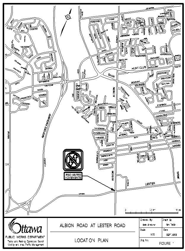
BACKGROUND
As directed by Council, in report
ACS2002-TUP-TRF-0038 (18 December 2002), staff are reporting back on the
impacts of the approval of the north-south straight through prohibitions at the
intersection of Albion Road and Lester Road.
This report provides the final assessment of the implementation of the
prohibition over the last three years.
This report:
- Provides an update on Council-approved prohibitions at the intersection of Albion Road and Lester Road;
- Summarizes the findings of the final technical evaluation of the traffic management measures that were implemented at the Albion Road and Lester Road intersection on 29 June 2004;
- Provides
information pertaining to the traffic levels and safety concerns
along Albion Road through the Blossom Park community; and;
- Confirms the appropriateness of the current north-south through movement prohibitions
at the intersection of Albion Road and Lester Road, in accordance with the
Council-approved Area Traffic Management Guidelines and the Transportation
Master Plan.
Assumptions and Analysis:
In July 2002, City
Council directed staff to undertake a focused Corridor Traffic Study for the
collector road section of Albion Road in the Blossom Park Community between
Lester Road and Bank Street, as a result of concerns brought forward by the
Blossom Park Community.
The study concluded
that measures to reduce traffic levels along Albion Road through the Blossom
Park community were justified in order to reduce traffic levels and to improve
community safety. After an evaluation
of the various alternatives for reducing traffic volumes, the prohibition of northbound
and southbound through traffic at the Albion Road at Lester Road intersection
was found to be the most appropriate action.
These prohibitions, as approved by Council, were implemented on 29 June
2004.
At the time of approval, Council directed staff to monitor the impacts of the prohibitions. This report details the final evaluation of the prohibitions approximately three years following the implementation.
l Traffic diversions to arterial streets without significantly affecting other community streets;
l No substantial impact on speeds along Albion Road (additional 1-1.5 minutes of travel time);
l No significant impact on travel times along the available alternative arterial routes;
l No significant safety or operational concerns for City of Ottawa service providers; and;
l Considerable reduction in the overall number of collisions on roadways within the Blossom Park Community since the implementation of the straight through prohibitions (a 23% reduction in the number of collisions)
l Reduced Level of Service at the Albion Road at Lester Road intersection,
l A significant number of complaints by the general public with respect to the prohibitions;
l Additional 1-1.5 minutes of travel time for commuters during peak periods; and;
l Increased collisions on the surrounding arterial road network (however, further analysis shows no discernable patterns for these collisions).
In the case of the implementation
of straight-through prohibitions at Albion and Lester Roads the education and enforcement
activities conducted by the police service have contributed to a very high rate
of compliance with the prohibitions of over 99%. Officers attending this location have also
noticed a change in driver behaviour, which has resulted in fewer requirements
for the police service to conduct education and enforcement activities at the
intersection.
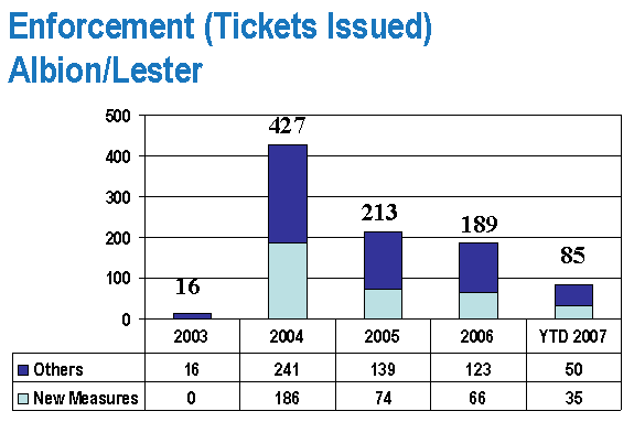
As expected, the number of traffic violations
issued increased significantly after the implementation of straight-through
prohibitions at Albion and Lester Roads.
For example, the number of Provincial Offence Notices (PONs) increased
in 2004 to 186 (offences that can be attributable to the new
prohibitions). The number of PON has
decreased every year since the implementation of the straight-through
prohibition and currently sits at 35 for the first six months of 2007.
In November 2004, Council approved the Area Traffic Management Guidelines after extensive consultation. The Guidelines suggest that turning movement and through movement prohibitions are appropriate tools in the overall plan in ensuring that community streets operate as intended; that is, in this case, for a collector road such as Albion Road to collect traffic from adjacent local roads in the community and direct them to/from arterial road network.
It should be noted that there are over 400 prohibited movements at various intersections currently listed in the City’s Traffic and Parking By-Law.
Prohibited movements are instituted to:
·
Minimize through
traffic on neighbourhood streets;
·
Address
intersection operational deficiencies; and/or,
·
Improve safety.
Examples of prohibitions include:
|
|
|
|
Jeanne D’Arc and Beausejour (East/West) |
Kimberley and Richmond (Westbound Left-turn) |
|
March and Teron (East) |
Innes and Pagé (Eastbound Left-turn) |
|
Corkstown and Moodie (East) |
Donald and North River Road (Southbound Left-turn) |
|
Moodie and Hunt Club West (North) |
Booth and Primrose (Eastbound Left-turn) |
|
Woodfield and Merivale (East/West) |
Westmount and Beverley (Westbound Right-turn) |
|
Bank and Cahill (East/West) Centrepointe and Baseline (North/South) |
Bank Street and Kitchener Avenue (Northbound Right-turn) |
This report provides a technical evaluation of
how effective the approved traffic management measures have been in terms of
fulfilling the recommendations of the Albion Road Corridor Study. This report is not intended to re-evaluate
the appropriateness of the Albion Road Corridor Study recommendations.
The attached Document 1: ‘Final Technical Evaluation: Albion Road at Lester Road Northbound and Southbound Through Movements Prohibitions’, summarizes the findings of the final technical evaluation of the traffic management measures that were implemented at the Albion Road and Lester Road intersection on 29 June 2004. This is the second of the two assessment reports that were prepared.
The initial technical evaluation report,
undertaken approximately one year following implementation, evaluated changes
in traffic patterns (and other factors as applicable) to gauge the degree to
which the project goals had been met, including the nature and extent of any
secondary impacts as a result of the project.
The final technical evaluation report, undertaken approximately three years following implementation, focuses on changes in collision patterns, frequency, and severity. It also evaluates changes in traffic patterns and considers operational or safety concerns with regard to Emergency Services, Transit Services, or Surface Operations activities.
Documents 2, 3, 4 and 5 provide further
background on the Albion Road Corridor Study process and the reasons behind the
north-south through movement prohibitions and Council’s previous considerations
of these prohibitions.
Document 2 is a copy of the Albion Road Corridor Study. The Study concluded that:
“…to address the issue of current and potential future “through” traffic volumes on Albion Road through Blossom Park, it is recommended that the northbound and southbound through movements at the Lester/Albion intersection be permanently restricted. This alternative most effectively minimizes non-local through traffic, while maintaining community accessibility to the extent possible. While the implementation of the preferred alternative results in pushing forward improvements to the area road network that might otherwise be deferred, unless through traffic is restricted, the subject section of Albion Road will not be able to function as its Official Plan designation and as the adjacent land uses imply it should.”
Document 3 is a copy of the staff report presented to the Transportation and Transit Committee on 4 December 2002 and approved by Council as amended on 18 December 2002.
Document 4 is a copy of a motion tabled by Osgoode Ward Councillor Doug Thompson. The motion was considered at the Transportation and Transit Committee on 2 June 2004 and again at Council on 9 June 2004. The motion requested that the implementation of the redesign of the Albion Road/Lester Road intersection to restrict north/north traffic movement on Albion Road not be initiated. This motion was not carried. Document 4 also contains the disposition by Council, the memorandum sent from the Deputy City Manager, Department of Public Works and Services, describing the project in detail and providing a complete chronology leading up to the Committee and Council approval of the straight through prohibitions.
Document 5 is a copy of an informational
package that was distributed to the public in the Spring of 2003, informing
them of the approved north-south straight through prohibitions as well as a
synopsis of the Albion Road Corridor Study.
TRANSPORTATION MASTER PLAN
The recommendation
to maintain the through movement prohibitions at the intersection Albion Road
and Lester Road is consistent with Transportation Master Plan, as stated in
Section 9.6:
- Area traffic management is a term that describes
both the process and techniques of preserving neighbourhood liveability by
mitigating undesirable effects of motor vehicle travel including excessive
volumes and speeds, aggressive driver behaviour and the creation of
unfavourable conditions for walking and cycling.
·
Consider a
wide range of area traffic management tools for application, including road
network modifications, traffic control devices, traffic calming measures,
streetscaping, enforcement, transportation demand management and public
education.
FINANCIAL IMPLICATIONS:
There are no financial implications as a result
of this report.
Of note, the original estimated cost of implementing the Albion/Lester straight through prohibition was $200,000, of which the actual cost to complete the works was $65,000. The remaining funding of $135,000 was transferred, with Council approval, to a separate project (904060) for the eastbound right turn lane on Lester Road at Albion Road. Further, an additional $150,000 was approved as part of the 2007 Capital Budget Network Modification Program for a total budget envelope of $285,000 to complete the eastbound right turn lane.
CONSULTATION:
No specific public consultations were undertaken in the preparation of this report. However, as part of the Final Technical Evaluation report a review of the impacts of the northbound and southbound through prohibitions on service providers was conducted for fire, police, emergency medical, public transit and surface operations.
In addition, the Final Technical Evaluation also reviewed communications received from the public since 29 June 2004. Although the vast majority of the communications were received within the first 2 to 3 months following implementation City staff and Councillors continue to receive communications from the public both in support and in opposition to the north-south straight through prohibition.
SUPPORTING DOCUMENTATION
Document 1 Final Technical Evaluation: Albion Road at Lester Road Northbound and Southbound Through Movements Prohibitions
Document 2 -
Albion Road Corridor Study, Delcan Corporation, February 2003
Document 3 Transportation and Transit Committee Report 33 on 4 December 2002 and Minutes of and Council Meeting of 18 December 2002
http://ottawa.ca/cgi-bin/docs.pl?Elist=2642&lang=en
Document 4 Transportation Committee Report 8 on 2 June
2004 and Minutes of Council Meeting of 9 June 2004 (Including the Memo
T08-01-ALBI from Deputy City Manager, Department of Public Works and Services
to the Chair and Members, Transportation Committee)
http://ottawa.ca/cgi-bin/docs.pl?Elist=3874&lang=en
Document 5 Information Package distributed to the Public in the Spring of 2003
Executive Summary
In July 2002, City Council directed staff to undertake a focused Corridor Traffic Study for the section of Albion Road in the Blossom Park Community between Lester Road and Bank Street, as a result of concerns brought forward by the Blossom Park Community. The study concluded that the combination of: the relatively high traffic levels using Albion Road through Blossom Park; the significant increase in these levels over the past few years; the relatively high percentage of this traffic that is through traffic; and the presence of arterial street alternatives to Albion Road provided justification for considering measures to reduce traffic levels along Albion Road through Blossom Park, and the redirecting of through traffic onto the surrounding arterial network. Of the various alternatives for reducing volumes that were evaluated, prohibiting northbound and southbound through movements at the Albion Road at Lester Road intersection was found to be the most appropriate. These prohibitions, as approved by Council, were implemented on 29 June 2004.
In terms of secondary impacts of the north-south prohibitions, those of note include: a reduced level of service at the Albion Road at Lester Road intersection; the significant number of complaints that have been raised by the general public with respect to the restrictions; and longer routes for commuters. In addition, there are a higher number of collisions on the surrounding arterial road network; however, a more detailed analysis of these collisions found that there is no identified trend or pattern for these collisions.
1.0 INTRODUCTION
This report provides a 3-year assessment of the northbound and
southbound straight-through movement restrictions that were implemented along
Albion Road at the Lester Road intersection on 29 June 2004. This is the second of two assessment
reports, as described below:
l
The initial
technical evaluation report undertaken approximately one year following
implementation evaluated changes in traffic patterns (and other factors as
applicable) to gauge the degree to which the project goals have been met,
including the nature and extent of any secondary impacts as a result of the
project.
l
This final
technical evaluation report undertaken approximately three years following
implementation focuses on changes in collision patterns and frequency. It also considers whether or not the traffic
management measures have created unacceptable operational or safety concerns
with regard to Emergency Services, Transit Services, or Surface Operations
activities.
This report represents the final technical evaluation of the measures that were implemented on 29 June 2004.
2.0 BACKGROUND
2.1 History
In July 2002, while considering a report on the potential relocation of the Central Canada Exhibition to a new site near the intersection of Albion Road at Rideau Road, Council approved a motion that included a requirement for a focused Corridor Traffic Study to be undertaken immediately for the section of Albion Road in the Blossom Park Community, between Lester Road and Bank Street. Residents of the area had raised a number of concerns, including:
l
Significant
growth in both peak hour and daily traffic volumes;
l
High proportions
of through traffic;
l
The speed of
traffic along Albion Road;
l
Safety concerns
for pedestrians, cyclists and motor vehicles travelling on or crossing Albion
Road; and,
l
The potential for
further increases due to continued urban growth of lands to the south.
Following both a technical review and a public consultation process the study concluded that the combination of:
l
The relatively
high traffic levels using Albion Road through Blossom Park;
l
The significant
increase in these levels over the past few years;
l
The relatively
high percentage of this traffic being through traffic; and,
l
The presence of
arterial street alternatives to Albion Road.
These conclusions provided the rationale for considering measures to reduce traffic levels along Albion Road through Blossom Park, and the redirecting of through traffic onto the surrounding arterial network. This conclusion is also in line with the City’s Area Traffic Management (ATM) Guidelines.
The project consultant evaluated a number of mitigation alternatives through the study process that could potentially limit through traffic within Blossom Park. Since both traffic volumes and through traffic were found to be at issue, each of the mitigation alternatives considered involved restrictions to entering or exiting the Blossom Park Community, and in particular to alternatives that were likely to be effective in reducing through traffic while at the same time minimizing impacts to community residents or to those who had specific destinations within the community. Of the alternatives evaluated, prohibiting northbound and southbound through movements at the Albion Road at Lester Road intersection was determined to be the most appropriate as these two movements made up between 85% and 95% of the total through traffic activity, and was found to have the least impact with respect to maintaining overall community accessibility. As per the ATM Guidelines, in addressing through traffic concerns, measures are considered if the proportion of through traffic exceeds 20% of the total traffic (with a minimum of 20 through vehicles per hour) and the solution is not expected to divert traffic to other streets of similar or lower classification.
Given the magnitude of the traffic affected by the proposed
prohibitions, the concept plan developed for the recommended alternative
included realignment and channelization of traffic lanes to prevent north-south
through movements and the construction of an eastbound right-turn lane to accommodate
traffic diverted to Lester Road. A
preliminary cost estimate for these modifications totalled approximately
$1.7M. In light of these substantial
costs, a lower cost, short-term derivative of the recommended alternative was
brought forward for consideration, which involved traffic control signal,
signage and pavement marking changes only, with funding for physical changes
being deferred for future budget consideration. This derivative was approved for implementation by City Council
in December 2002.
2.2 Street Characteristics
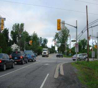
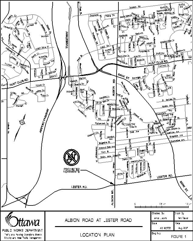
Albion Road and Lester Road have the following characteristics (see also
Figure 1):
l
In the City of
Ottawa’s Official Plan, Albion Road is classified as a collector road north of
Lester Road and an arterial road south of Lester Road. Lester Road is classified as an arterial
road;.
l
Both approaches
along Lester Road and the northbound approach along Albion Road are two-lane
roadways, built to rural standards (i.e. gravel shoulders, no-curbs, no
sidewalks). Albion Road north of the
intersection (leading to/from the Blossom Park Community) is also a two-lane
roadway but with curbs and sidewalks.
One additional turn lane is provided along each approach to the
intersection;
l
There are no
separate bike lanes on any of the approaches to the intersection;
l
Albion Road has a
posted speed limit of 50 km/h north of the intersection and a posted speed
limit of 80 km/h south of the intersection.
Lester Road has a posted speed limit of 80 km/h both east and west of
the intersection;
l
Parking is
restricted north of the intersection along the east side of Albion Road, and
within 15 m of the intersection for all other approaches;
l
All approaches to
the intersection currently have street lighting;
l
Lands on three of
the four adjacent quadrants (northwest, southwest and southeast) form part of
the NCC Greenbelt. Lands to the
northeast are currently being developed as residential; and,
l
An additional
eastbound right-turn lane along Lester Road is scheduled for construction
during the Summer of 2007.
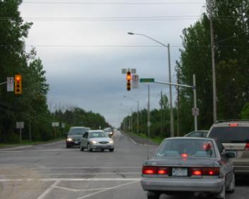
2.3 Description of Measures
On 29 June 2004, the following actions were taken:
l
At the
intersection of Albion Road and Lester Road northbound and southbound
straight-through vehicle movements were prohibited at all times of the day –
all other movements at the intersection continued to be permitted;
l
Authorized
vehicles were exempted from these prohibitions, including transit vehicles and
emergency services vehicles;
l
The prohibitions
were put into effect through the use of traffic control signals, signs and
pavement markings; and,
l
No physical
changes to these roadways were undertaken.
On 3 September 2004, “No U-Turn” signs were installed on Lester Road (to a point 150 m either side of Albion Road), in an effort to address safety concerns and respond to public concerns associated with drivers performing U-Turns on Lester Road. This action coincided with enhanced police monitoring and enforcement.
On 14 September 2004, a temporary
variable message sign was installed adjacent to 2496 Bank Street indicating “No
Through Traffic Albion at Lester ”.
This sign was in place for approximately three (3) weeks.
On 17 September 2004, additional No U-Turn signs were installed (to a point 500 m either side of Albion Road), based on continued concerns regarding both safety and drivers circumventing the intention of the through movement prohibitions.
On 3 December 2004 an advanced westbound left-turn arrow was added to the existing signal cycle, to reduce delays for this movement.
In
2006, a road closure was implemented by Carleton Condominium Corporation 164 on
Aladdin Lane (private road), immediately north of Lester Road, as a result of
concerns of increased through traffic using Aladdin Lane.
In August 2007 a new right-hand turn lane is scheduled for construction on Lester Road, at Albion Road, for eastbound traffic.
3.0 BEFORE AND
AFTER” TECHNICAL ANALYSIS
3.1 Traffic Volumes
Monitoring of the traffic volumes was carried
out to ascertain changes to traffic patterns in the surrounding area as a
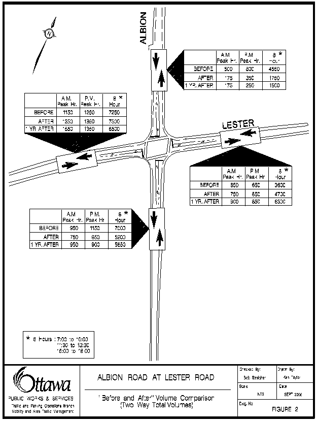
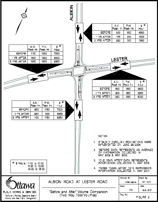
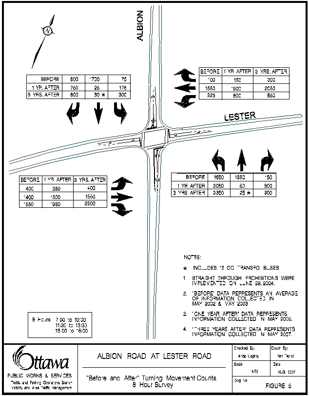
result of the measures implemented at Albion Road and Lester Road. Figures 2 through 5 summarize the results of
the comparative “before and after” volume surveys. The “Before” information in these figures represents an average
of 2002 and 2003 information collected during the spring period of these years;
the “1 Year After” information represents information collected during the
spring of 2005; and the “3 Year After” information
represents data collected during the Spring of 2007.
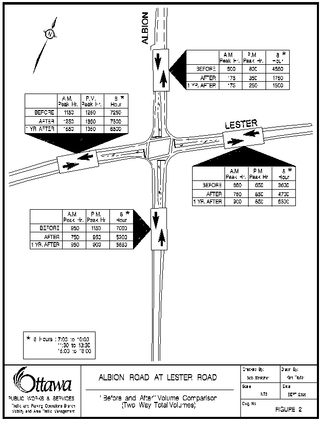
Figure 2 provides details of changes to link volumes along each of the
four approach legs of the Albion Road at Lester Road intersection. As expected, volumes along both legs of
Lester Road have increased since the implementation of the north/south through
movement restrictions. Also as expected,
volumes along Albion Road immediately north of Lester Road were reduced to
approximately one-third of previous levels in 2005 (1,500 vehicles over the
8-hour count period, compared to 4,550 vehicles previously), and in 2007 are at approximately 40% of the 2004 levels
(currently 1,850 vehicles over the 8-hour count period). Along Albion Road to the south of the
intersection, changes in volumes have been relatively minor.
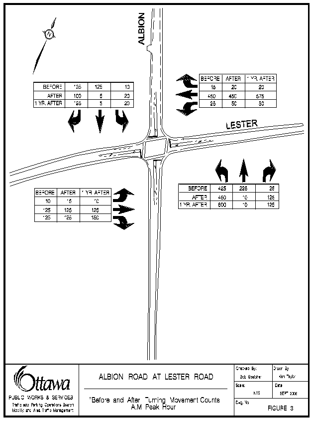
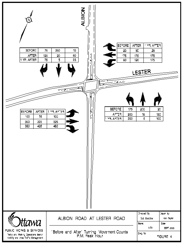
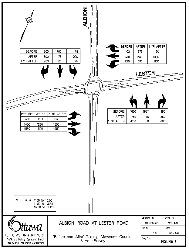
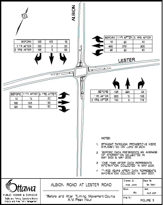
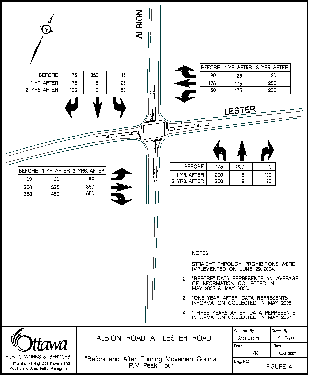
Figures 3, 4 and 5, provide details on how turning movements at the
Albion Road at Lester Road intersection have been affected for the AM commuter
peak hour, the PM commuter peak hour and for the 8 hour total survey period,
respectively. Over the total 8-hour
turning movement count survey period, 75 vehicles in 2005, and 55 in 2007, were recorded traveling
either northbound or southbound straight through the intersection. These include authorized vehicles such as
the 13 in-service OC Transpo buses, which are exempted from the restrictions. This represents in the range of 99 % compliance
(42 vehicles currently—excluding OC Transpo buses vs. 3,350 vehicles
previously). This level of compliance
is considered to be high given the lack of physical measures at the
intersection to restrict through movements.
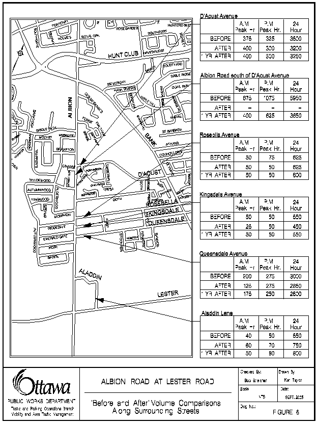
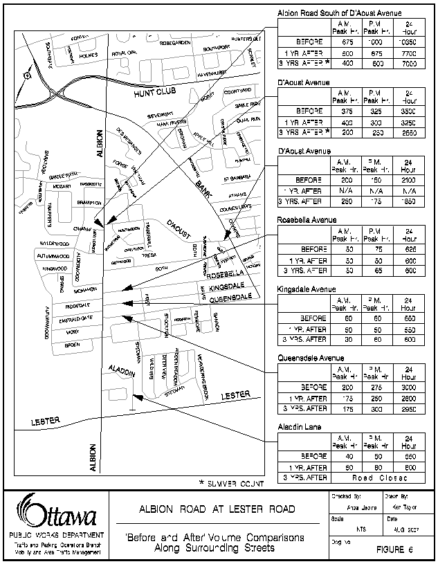
Figure 6 provides “Before” and “After” traffic volume details along
other community streets in the general area that could potentially have been
impacted by the prohibitions at the Albion Road at Lester Road
intersection. There does not appear to
have been any significant negative impacts along any of the alternative
community streets. Volumes along
Rosebella Avenue, Kingsdale Avenue, Queensdale Avenue, and D’Aoust Avenue
between Bank Street and Albion Road, have remained essentially unchanged.
3.2 Traffic Speeds
Table 1 provides details of before and after speed surveys along Albion Road through Blossom Park. Travel speeds of traffic along Albion Road have not changed significantly as a result of the northbound and southbound through movement restrictions at the Albion Road at Lester intersection.
Table 1 – Albion
Road Speed Analysis
|
Location |
Average (km/h) |
85th percentile*
(km/h) |
||||
|
Before (2002) |
After (2005) |
After (2007) |
Before (2002) |
After (2005) |
After (2007) |
|
|
Albion
Road between Lester Road and Aladdin Lane |
60 |
58 |
55 |
68 |
67 |
63 |
|
Albion
Road between McMahon Avenue and Goth Avenue Avenue |
59 |
58 |
57 |
67 |
66 |
64 |
|
Albion
Road between Des Mesanges Drive and Forge Street |
59 |
62 |
61 |
66 |
70 |
68 |
Note:
* – The 85th percentile is the speed at or
below which 85 % of the vehicles travel.
3.3 Levels of Service
Table 2 provides Level of Service (LOS) and volume to capacity ratio
(v/c) summaries of the major intersections in the area both before and after
the implementation of through movement restrictions.
Table 2 – “Before and After” Levels of Service
|
Intersection |
AM
Peak Hour |
PM
Peak Hour |
||||||||||
|
Before |
1
Year After |
3
Years After |
Before |
1
Year After |
3
Years After |
|||||||
|
LoS |
v/c |
LoS |
v/c |
LoS |
v/c |
LoS |
v/c |
LoS |
v/c |
LoS |
v/c |
|
|
Albion Road at Lester
Road |
C |
0.75 |
E |
0.95 |
E |
0.96 |
D |
0.86 |
E |
0.99 |
F* |
1.05 |
|
Bank Street at Lester
Road |
B |
0.68 |
B |
0.60 |
A |
0.47 |
C |
0.78 |
A |
0.59 |
A |
0.48 |
Note:
The Transportation Master
Plan indicates that intersections outside the Core area should operate at LOS D
or better during peak hours.
* The LOS is expected to
improve to C as a result of the implementation of an eastbound right-turn lane
on Lester Road at Albion Road.
The two
Lester Road/Uplands Drive intersections with the Airport Parkway ramps were
All-Way STOP controlled intersections until late 2005; both of these
intersections met warrants for conversion to traffic control signals in 2003
(i.e. previous to the through movement restrictions). Installation of traffic control signals at both of these
intersections occurred in the Fall of 2005/Spring of 2006 and these
intersections currently operate at the Level of Service A and C during the
morning and afternoon peak period, respectively.
The intersection of Albion Road and Lester Road is in an area where
increased traffic pressures have been occurring, and will continue to occur as
a result of development growth (the impact of this growth on the Blossom Park
Community was one of the reasons the through movement prohibitions on Albion
Road at the Lester Road intersection were seen as being justified). The Albion Road and Lester Road intersection
had previously been identified as potentially requiring an eastbound right-turn
lane due to growth, even before the through traffic restrictions were
approved. This right-turn
lane on Lester Road is scheduled for
construction starting in August 2007. Upon completion, the intersection operation is expected to improve to a
volume to capacity ratio of 0.77 (LOS C), for the PM peak hour; while the AM
peak hour volume to capacity ratio would not change, as the eastbound
right-turn movement is not one of the critical movements during the morning
peak period. Of particular note, during
the AM peak hour, volumes heading westbound along Lester Road, west of the
Albion Road intersection, are currently in the range of 1,300 vehicles per
hour, which is approaching the lane capacity of a two-lane arterial road.
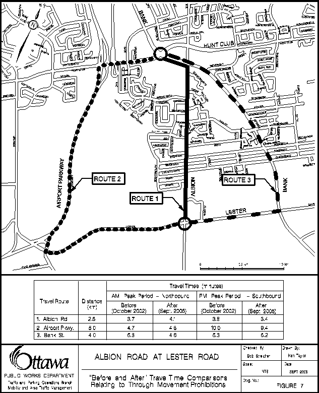
3.4 Travel Times
Figure 7 provides a comparison of travel time runs
of the two primary alternatives routes (the Airport Parkway and Bank Street)
with travel times associated with using Albion Road through the Blossom Park
Community. Each of the times that are
shown represent an average of three separate travel runs during the commuter
peak travel period in the peak travel direction. The common start and end points for each run were the Albion Road
at Lester Road intersection to the south, and the Bank Street and Hunt Club
Road intersection to the north. A
comparison of before and 1 year after travel times suggests little to no
additional delays along the two alternative arterial road routes than what existed
previous to the prohibitions being in place.
Table 3 illustrates the additional time that
commuters in the morning and afternoon peak hours experience by using the
Lester Road/Bank Street link as opposed to Albion Road.
Table 3 – Travel
Time Comparison
|
Route |
Travel time (minutes) |
|
|
AM peak northbound |
PM peak southbound |
|
|
Via
Albion Road (before) |
3.7 |
3.8 |
|
Via
Lester Road/Bank Street (after) |
4.6 |
5.2 |
The additional travel times are:
AM peak
northbound: 4.6-3.7 minutes = 54 seconds
PM peak southbound: 5.2 – 3.8 minutes = 84 seconds
3.5 Traffic Violations
The education and enforcement
activities conducted by the police service have contributed to a very high rate
of compliance with the prohibitions of over 99% (42 vehicles currently
vs. 3350 previously, as per the 8-hour tuning movements counts). Officers attending
this location have also noticed a change in driver behaviour, which has
resulted in fewer requirements for the police service to conduct education and
enforcement activities at the intersection.
A
number of vehicles have been noted making use of the former Aladdin Lane access
from Lester Road as a turn-around area when travelling along Lester road (60
vehicles over a 5 hour period in 2007).
Based on these observations, and as this movement presents a safety
risk, City staff have recently issued a work order for a “No Left-Turn” sign at
this location, which will make such movements illegal.
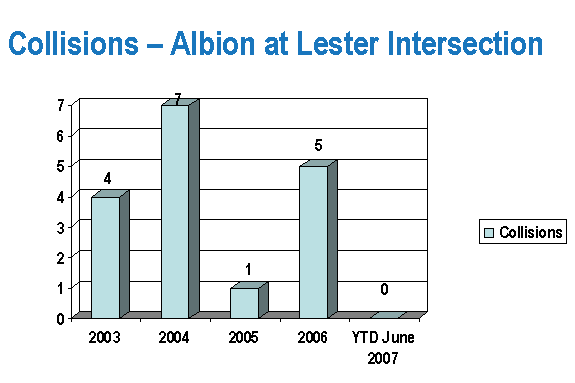
3.6 Collisions
A full assessment of
changes in collisions patterns normally includes 3 years of before and after
collision data. Due to constraints on
data availability, collisions were collected for both the 2½ year period
immediately preceding and immediately following the implementation of the
through movement restrictions (see Table 4).
All of the noted collisions were reported as involving property damage
only, or non-fatal injuries.
As one of the objectives of the through
movement restrictions had been to improve safety for residents within the
Blossom Park Community, a comparison of the total number of collisions that has
occurred within this Community is an appropriate indicator of the overall
effectiveness of these restrictions.
For the 2½ year period immediately preceding the implementation of the
through movement prohibitions, there were 70
reported collisions within the Blossom Park Community. This figure has been reduced considerably, to
54 collisions, during the 2½ year after period (a reduction of 23%). Along the section of Albion Road between
Lester Road and Bank Street, the number of collisions during the same time
period has also reduced, but to a lesser degree, from 27 before to 23 after.
While
the number of collisions within the Blossom Park Community has decreased, the
number of collisions on the surrounding arterial network has increased. Due to this increase, further analysis was carried
out to determine if there is a discernable pattern observed for these
collisions.
l
Albion
Road and
Lester Road intersection:
Of the 7 reported collisions during the 2.5 years before
the implementation of the through movement, three (3) involved rear-end
collisions, three (3) involved angle collisions, and one involved a left-turn
movement collision. Of the 10 reported collisions during the 2.5 years
following the implementation of the through movement, one involved a U-turn
manoeuvre, five (5) involved a rear-end, three (3) involved turning movements,
and one involved a single vehicle losing control. Of the seven (7) ‘before’ collisions, three (3) were attributed
to weather-related conditions (i.e., road surface being
wet/icy/snow-covered). For the ‘after’ period, six (6) out of the 10 collisions were
weather-related (four (4) out of these six (6) weather-related collisions
resulted in rear-end collisions). An assessment of the collisions at
this location has revealed no specific pattern to suggest any particular safety
issue at this intersection.
Table 4 – “Before and After” Collision Data
|
Location |
Date/Durative |
Total Collisions |
U-Turn
Collisions |
Pedestrian
Collisions |
Cyclist
Collisions |
|
Albion Road and Lester Road Intersection |
Before (2.5 years) |
7 |
0 |
0 |
0 |
|
After (2.5 years) |
10 |
1 |
0 |
0 |
|
|
Lester Road and Bank Street Intersection |
Before (2.5 years) |
2 |
0 |
0 |
0 |
|
After (2.5 years) |
16 |
0 |
0 |
0 |
|
|
Albion Road and Bank Street Intersection |
Before (2.5 years) |
16 |
0 |
0 |
0 |
|
After (2.5 years) |
13 |
0 |
0 |
0 |
|
|
Albion Road between Lester Road and Bank Street* |
Before (2.5 years) |
27 |
0 |
2 |
1 |
|
After (2.5 years) |
23 |
0 |
0 |
2 |
|
|
Lester Road between Albion Road and Bank Street** |
Before (2.5 years) |
1 |
0 |
0 |
0 |
|
After (2.5 years) |
6 |
2 |
0 |
0 |
|
|
Lester Road between Albion Road and Airport Pkwy*** |
Before (2.5 years) |
8 |
0 |
0 |
0 |
|
After (2.5 years) |
12 |
4 |
0 |
0 |
|
|
Roadways within Blossom Park Community**** |
Before (2.5 years) |
70 |
N/A |
5 |
4 |
|
After (2.5 years) |
54 |
N/A |
4 |
3 |
Note:
“Before”
represents collision data collected, for 2.5 years, between the dates 01
January 2002 to 28 June 2004.
“After”
represents collision data collected, for 2.5 years, between the dates 29 June
2004 to 01 January 2007.
*Excludes
collision data from the intersections of: Albion Road and Lester Road, and
Albion Road and Bank Street.
**Excludes collision data
from the intersections of: Lester Road and Albion Road, and Lester Road and
Bank Street.
***Excludes
collision data from the intersections of: Lester Road and Albion Road, and
Lester Road and Airport Pkwy.
****Excludes
collision data from all intersections along:
Lester Road, Bank Street, and Hunt Club Road.
l
Bank
Street and Lester Road intersection:
Of the 16 reported collisions during the 2.5 years
following the implementation of the through movement prohibitions at the Albion
Road and Lester Road intersection, only three (3) collisions involved eastbound
left turns from Lester Road or southbound right turns from Bank Street. These are the movements that one expects to
be attributable to the diverted traffic from the Albion Road and Lester Road
intersection. The remaining collisions
at this intersection included primarily sideswipe, rear-end, and angle
collisions. One of the major
contributory factors to the increase in collisions at this intersection could
be the significant growth in traffic along Bank Street in recent years. Turning movement counts from this
intersection indicate that the 8-hour daytime volumes along the south leg of
the Bank Street have increased 33% between 2001 and 2007. In fact, when considering the additional
evening activities associated with the recent expansion of the Rideau Carleton
Raceway, the growth in daily volumes is likely even higher, particularly at the
end of the week and during weekends. An assessment of the collisions at
this location has revealed no specific pattern to suggest any particular safety
issue at this intersection.
l
Lester Road:
Albion Road to Bank Street:
In the 2.5 year period preceding the implementation of the through movement prohibitions, the section of Lester Road between Albion Road and Bank Street experienced one (1) collision. This collision involved a vehicle and a deer. In the same period of time after the implementation of the through movement prohibitions there were six (6) collisions. Two (2) of these collisions involved vehicles striking a deer, two (2) collisions involved eastbound vehicles making U-turns (one with charges laid, and the other turning left onto Aladdin Lane to complete a U-turn), and two collisions involved a single vehicle losing control due in part to pavement conditions.
l
Lester Road:
Albion Road to Airport Parkway:
In the 2.5 year period preceding the implementation of the through movement prohibitions, the section of Lester Road between Albion Road and the Airport Parkway experienced eight (8) collisions. Two (2) of these collisions involved vehicles striking a deer, four (4) involved single vehicle collisions, and two (2) others involved rear end and sideswipe contacts. In the same period of time after the implementation of the through movement prohibitions there were 12 collisions. Two (2) of these collisions involved vehicles striking a deer, four (4) involved vehicles executing U-turns (two with charges laid), four (4) involved rear end or side-swipe contact, and two (2) involved a single vehicle.
When these additional factors are considered
while reviewing the collision statistics, the before and after numbers along
the surrounding arterial streets can be more readily justified. In each case, although the total number of
collisions was higher than the previous 2.5 year period, staff were unable to
identify a specific reason for the increases, or to determine a correlation
between the increased number of collisions and the through movement
prohibitions installed in June 2004, other than those relating to U-turn
movements along Lester Road.
It is
the City’s practice that a detailed analysis/study be undertaken when a
particular pattern of collisions (i.e., rear-end, right angle, etc.) is
observed to occur six (6) times or more at an intersection or a link over a
three (3) year period. While the number
of collisions has increased over the past 2.5 years, given there is no
identified collision pattern, no further evaluation is deemed to be warranted.
Surface Operations did not have any maintenance or
operational concerns. The prohibitions
at the intersection have had minimal impact on the maintenance and operation of
the road network in the area.
5.0 CONCERNS BROUGHT FORWARD
BY THE PUBLIC
Since the 29 June 2004, implementation of these through movement prohibitions City staff have received a significant number of communications from the public. As of October 2005, the Traffic and Parking Operations Branch received approximately 300 emails and/or letters and 40 telephone calls in opposition to these restrictions and approximately 10 letters and/or emails in support of these measures (the vast majority of these were received within the first 2 to 3 months following implementation). The concerns that were raised by the public could be generally grouped into the following areas:
l
The prohibitions
result in more circuitous routes for people living on Albion Road, or with
local destinations;
l
Albion Road has
been opened for many years and has always been used as a commuter route to and
from the south. People to the south used Albion Road to patronize businesses on
Albion Road, and at the intersection of Albion Road and Bank Street;
l
The intersection
configuration is confusing and unsafe;
l
A few people are receiving preferential
treatment at the expense of many others (urban vs. rural);
l
People living to
the south of the Albion Road and Lester Road intersection are being forced to
drive further and burn more fuel, and this is contrary to guidelines in the
City’s Official Plan regarding reducing CO2 emissions;
l
Delays traveling
through this intersection have increased causing vehicle queuing in both the
morning and afternoon peak hours;
l
The prohibitions
have resulted in traffic diverting to nearby local roads such as: Queensdale,
Kingsdale, Rosebella, and D’Aoust Avenues; and;
l
Residents from
Carleton Condominium Corporation 164, located just northeast of the
intersection had contacted staff, through their Property Management Director,
with concerns over increased through traffic along Aladdin Lane, which is a
private road. (In 2006 a road closure
was implemented along Aladdin Lane; immediately north of Lester Road, by
Carleton Condominium Corporation 164).
l
High compliance
levels with the current restrictions (and improved, when compared with the one
year evaluation);
l Traffic diversions to arterial streets without significantly affecting other community streets;
l No significant impacts on speeds along Albion Road;
l No significant impact on travel times along the available alternative arterial routes;
l No significant safety or operational concerns for City of Ottawa service providers; and,
l Considerable reduction in the overall number of collisions on roadways within the Blossom Park Community since the implementation of the straight through prohibitions.
l Reduced Level of Service at the Albion Road and Lester Road intersection (the construction of an eastbound right-turn lane on Lester Road at Albion Road is expected to be completed in Fall 2007, which will improve the LoS during the afternoon peak);
l Significant number of complaints that have been raised by the general public with respect to the prohibitions;
l Additional 1-1.5 minutes of travel time for commuters during peak periods; and,
l Increased collisions on the surrounding arterial road network (however, further analysis showed no discernable patterns for these collisions).
“BEFORE AND AFTER” VOLUME COMPARISONS
ALONG SURROUNDING STREETS
“BEFORE AND AFTER” TRAVEL TIME COMPARISONS
RELATING TO THROUGH MOVEMENT PROHIBITIONS
Document 2
Albion Road Corridor Study, Delcan Corporation,
February 2003
Table of Contents
Table 1 – Albion Road Speed
Analysis
Table 3 – Travel
Time Comparison
2.0 Recent
Area Traffic Growth
3.0 Quantification
of Non-Local “Through” Traffic
3.1 Racetrack
/ Slots Traffic Flows
4.0 Existing
Traffic Speed Data
5.0 Potential
Traffic Increases Due to Proposed Area Developments
5.1 Central
Canada Exhibition (CCE) Relocation
6.0 Summary
of Potential Mitigation Measures
6.1 Potential
Diverted
Traffic Impacts
7.0 Preliminary
Technical Recommendation
9.0 Potential
Traffic Impacts of Preliminary Technical Recommendation
Purpose
of Study and Background
Bank Street south of Albion Road
Evaluation of Potential Mitigation Measures
Monitoring and Evaluation Program
List of Figures
Figure 1: Origin-Destination Locations………………………………………………………………
List of Tables
Table 1: Non-Local “Through”
Traffic Flows Through Blossom Park
Table 2: Racetrack / Slots Traffic Traveling Through Blossom Park
Table 3: Speed Survey Summaries
Table 4: Range of Potential
Diverted Traffic Impacts
Table 5: Existing Levels of Service for Key Study Area Intersections
Table 6: Projected Levels of
Service Due to Traffic Reassignment (Year 2003)
Table 7: Projected Levels of
Service Due to Traffic Reassignment (Year 2008)
1.0
Background
As the Blossom Park community has developed out and as
through traffic on the local section of Albion Road continues to increase,
Albion Road’s current function and its adjacent land uses are beginning to
conflict. There are a number of recent development applications in the
immediate area (i.e. Canada Lands Company) and significant future urban and
rural growth is being planned to the south that could compound current traffic
issues.
Among the issues identified to date by community residents
and City staff are significant recent growth in both peak hour and daily
traffic volumes, a high perceived proportion of “non-local” traffic cutting through
the community and the speed of traffic on Albion Road. The combined volume and
speed of traffic creates safety concerns for local pedestrians, cyclists and
motor vehicles travelling on, or crossing, Albion Road and there is the
acknowledged potential for further traffic increases on Blossom Park roads due
to proposed new developments.
In July of 2002, in response to these ongoing concerns, City
Council directed their staff to undertake a focussed traffic study on the
residential portion of Albion Road between Bank Street and Lester Road to
address / resolve transportation-related issues along the corridor. Based on
the findings of this study, a number of options for controlling traffic volume
through Blossom Park were brought forward and are summarized herein.
2.0
Recent Area Traffic Growth
As part of the extensive data collection undertaken for this
Albion Road Corridor Review, the City conducted both an Origin-Destination
(O-D) Survey and Automatic Traffic Recorder (ATR) counts during the weeks of
August 27th, 2002 and September 25th, 2002. Spot speed
surveys and turning movement counts at key intersections were also reviewed.
Traffic counts and speed surveys were compared with historical data to assess
the trends in growth or decline.
Traffic volumes on the subject section of Albion Road
(Lester Road to Bank Street) have increased significantly since the last set of
available turning movement counts conducted in the Summer of 2000. Prior to
2000, traffic volumes had been, on average, somewhat stable after experiencing
some decline following completion of the Hunt Club / Airport Parkway
interchange. Between 2000 and 2002, traffic volumes immediately north of Lester
Road increased significantly by 64% and 59% in the AM and PM peak hours,
respectively. The absolute value of the hourly increase ranges from 200 to 300
vph depending on the section of road and the time period. Over a 24 hour
period, and after adjustment for seasonal variation, the daily increase over
this two-year period equates to approximately 1,660 vehicles (+35%) on Albion
Road north of Lester Road and approximately 1,240 vehicles (+14%) on Albion
Road south of Bank Street.
Based on the August 2002 ATR counts taken at a location
immediately north of Lester Road and at a location immediately south of Bank
Street, the total Albion Road (through Blossom Park) two-way peak hourly
traffic volumes are as follows:
•
immediately north of Lester Road: 500
vph AM peak
820
vph PM peak
•
immediately south of Bank Street: 680
vph AM peak
1,060 vph PM peak
The data was recorded between August
16th and August 28th, 2002. Although day-to-day volumes
varied naturally throughout the week of study, the above-noted volumes were
considered representative of the higher end of the weekday peaks recorded.
The subject section of Albion Road
through Blossom Park is designated as a collector road in the former City of
Gloucester Official Plan. It is important to understand the rationale behind
the roadway classification system. Most community traffic issues arise when a
roadway's designated function and actual function conflict.
Albion Road is designated as a collector road north of Lester Road and as an
arterial road south of Lester Road. A road's designation as
"collector" versus "arterial” does not necessarily reflect its physical
ability to carry / accommodate traffic (i.e. its capacity). A road's intended
function, however, does provide a guideline for what is considered to be a tolerable
level of traffic for the land uses that are adjacent to it. For example, the
function of an arterial is to primarily move high volumes of regional-type
traffic, with less emphasis on providing access to adjacent development. As
this is currently the case for Albion Road south of Lester Road, its intended
and actual functions are therefore compatible. A collector's function, on the
other hand, is to carry some traffic volume, primarily community-generated
traffic, as well as to provide access to adjacent land uses. When a road is
designated as a collector, it usually has more residential and neighbourhood
oriented land uses along it compared to an arterial, and there will be more
driveways and local street intersections. As such, there is lower tolerance for
higher traffic volumes and speeds due to safety, noise and convenience issues.
As total traffic volume and the amount of non-local “through” traffic
increases, a collector road actually functions more and more like an arterial
road and can cause growing conflict between its designated function and its
actual function. Traffic management solutions such as turning movement
restrictions and physical diversions can help to correct this type of conflict.
As mentioned, a second set of ATR
counts were collected in September, 2002 to determine if traffic flows changed
due to local schools being in session. The results of these updated counts
indicated that average traffic volumes during the morning peak hour had
increased approximately 20% over the section of Albion Road through Blossom
Park. During the afternoon peak and over the course of a weekday, volumes were
the same or slightly lower than in August. Weekend daily volumes increased up
to 20% immediately south of Bank Street.
The following are considered
representative of two-way peak hour traffic volumes during a typical weekday morning
peak while school is in session:
•
immediately north of Lester Road: 575
vph
·
immediately south of Bank Street: 790 vph
This Fall data is important for
highlighting the fact that commuter traffic volumes have generally increased
through Blossom Park, and cannot be explained simply by seasonal variation and
specific land uses such as area schools.
3.0
Quantification of Non-Local “Through” Traffic
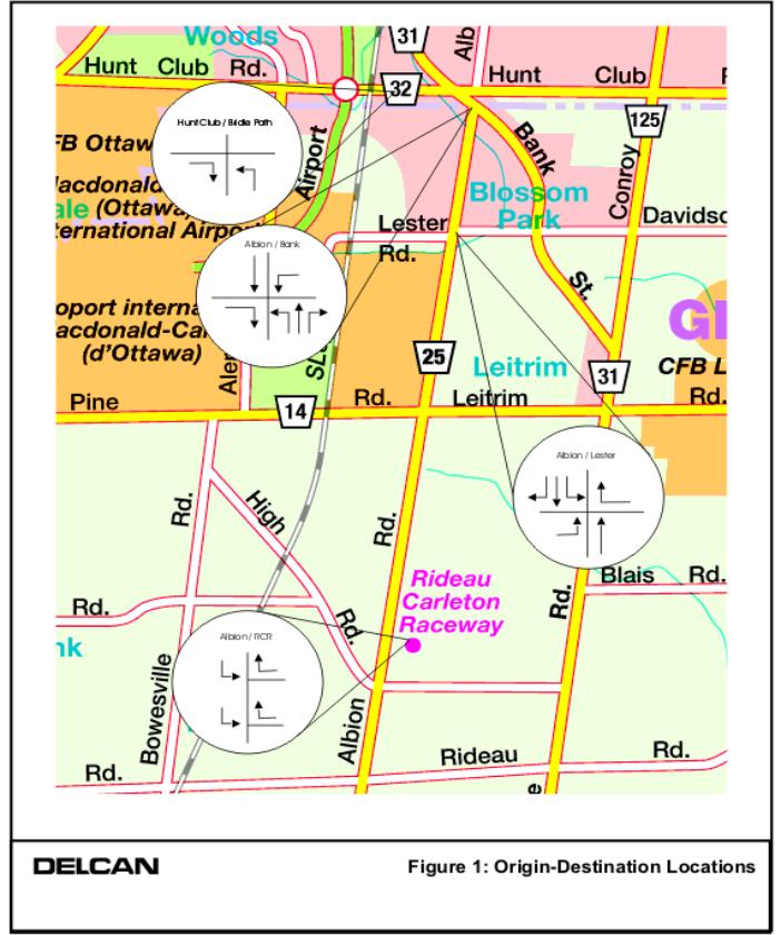
The map attached as Figure 1
illustrates the origin and destination points used for the first Origin-Destination
study in late August, 2002. License plate numbers were recorded for turning
movements at the intersections of Hunt Club / Bridle Path, Bank / Albion,
Albion / Lester and the two northerly Rideau Carleton Raceway driveway intersections with Albion Road.
Plate matches were used to estimate the percentage of non-local traffic for
each intersection movement.
For the AM peak period, two traffic
flows were analyzed; the predominant commuter flow (south to north) and the
reverse commuter flow (north to south). For the PM peak, the same two
directions of commuter traffic were analyzed, in addition to traffic flows to
and from the Rideau Carleton Raceway / Slots facility. Note that this Raceway /
Slots traffic is also accounted for in the totals for commuter traffic, as it
constitutes non-local traffic. The percentage of non-local through traffic over
the peak periods was converted to an equivalent peak hourly volume, derived
from the most recent turning movement counts at area intersections (included in
Appendix A), to provide a better basis for comparison. Table 1 summarizes the
resultant estimated “through” traffic flows through Blossom Park.
Table 1: Non-Local “Through” Traffic Flows Through Blossom Park
|
Movement |
AM Peak
Hour |
PM Peak
Hour |
||
|
% of
Movement Classified as “Through” Traffic |
Equivalent
vph, Typical Weekday* |
% of
Movement Classified as “Through” Traffic |
Equivalent
vph, Typical Weekday* |
|
|
Eastbound Right-Turn from Hunt
Club to Bridle Path |
4% |
4 |
5% |
15 |
|
Eastbound Right-Turn from Bank
to Albion |
41% |
41 |
49% |
153 |
|
Southbound Through at Bank /
Albion |
30% |
38 |
30% |
79 |
|
Westbound Left-Turn from Bank to
Albion |
12% |
4 |
60% |
26 |
|
Westbound Right-Turn from Albion
to Lester |
20% |
2 |
17% |
2 |
|
Eastbound Left-Turn from Albion
to Lester |
20% |
2 |
14% |
17 |
|
Northbound Through at Albion /
Lester |
50% |
110 |
48% |
94 |
|
*equivalent vph based on most recent turning movement
counts provided by the City (May / June 2002) |
||||
Based on the Table 1 results, the
magnitude of two-way non-local “through” traffic on Albion Road through Blossom
Park is estimated to be in the order of 200 vph and 385 vph in the morning and
afternoon peak hours, respectively.
The percentage of non-local
”through” traffic on Albion Road through Blossom Park is estimated to be
between 29% and 47% during summer months, as follows:
- immediately
north of Lester Road: 40% AM peak
(200 / 500 vph)
47%
PM peak (385 / 820 vph)
- immediately
south of Bank Street: 29% AM peak
(200 / 680 vph)
36%
PM peak (385 / 1060 vph)
As
previously mentioned, a second O-D Survey was undertaken in late September 2002
to capture any changes in travel patterns as a result of the new school
year. This Fall survey found
significantly fewer matching plates representing “through” traffic, estimated
to be in the order of 120 vph and 210 vph in the morning and afternoon peak
hours, respectively.
The
percentage of non-local “through” traffic on Albion Road through Blossom Park
is estimated to be between 15% and 28% during months when school is in session,
as follows:
- immediately
north of Lester Road: 21% AM peak
(120 / 575 vph)
28%
PM peak (210 / 750 vph)
- immediately
south of Bank Street: 15% AM peak
(120 / 790 vph)
20%
PM peak (210 / 1025 vph)
Although
the findings of the September, 2002 survey suggest approximately half as much
non-local “through” traffic compared to the August 2002 survey, there are
several explanations for this, including:
·
a higher proportion of school-related traffic in the AM peak, which
would exhibit “local” traffic patterns;
·
although not found to be a major “through” traffic route in the first
survey, Bridle Path Drive was not included in the September survey;
·
the hours of study for the PM peak were extended an extra hour to
account for the total peak period, which may have “diluted” some of the
“through” traffic that is typically associated with the commuter peak hour; and
·
construction activity was noted immediately south of Bank Street during
the survey hours, with traffic being controlled by a flagperson. While this did
not appear to affect total traffic volumes on Albion Road significantly, it may
have caused some drivers to shift their routes in advance of the disruption.
3.1
Racetrack / Slots Traffic Flows
These traffic movements were only measured during the
afternoon peak as the facility is not in operation during the morning peak
hour. Note that inbound (southbound) traffic to the Racetrack / Slots is not
presented due to the difficulty experienced in reading and recording license
plates for these vehicles, resulting in a very low number of plate matches.
Table 2: Racetrack / Slots Traffic
Traveling Through Blossom Park
Movement |
PM Peak
Hour |
|
|
% of
Movement Classified as “Through” Traffic |
Equivalent
vph, Typical Weekday* |
|
|
Westbound Right-Turn from Rideau
Carleton Raceway North Access (unsignalized) to Albion Northbound |
11% |
1 |
|
Westbound
Right-Turn from Rideau Carleton Raceway South Access (signalized) to Albion
Northbound |
20% |
25 |
|
*equivalent
vph based on most recent turning movement counts conducted by the Consultant
/ City |
||
Based on the Table 2 data, the contribution of
outbound (northbound) Rideau Carleton Raceway traffic to northbound “through”
traffic in Blossom Park is estimated to be 23% (26 / 113) during the afternoon
commuter peak hour. The remaining 77% of total “through” traffic is originating
in other areas south of Lester Road.
4.0
Existing Traffic Speed Data
Speed
surveys were conducted at three locations along the subject section of Albion
Road. Table 3 summarizes the survey findings. The posted speed limit is 50
km/h.
Table 3: Speed Survey Summaries
|
Location (Date of
Survey) |
Two-way
Traffic Data |
||
Average Speed |
85th
Percentile Speed |
Percentage
Complying with 50 km/h Speed Limit |
|
|
Albion between Des Mesanges and Forge (Nov. 28th, 2000) |
61 km/h |
68 km/h |
5% |
|
Albion between Goth and McMahon (Sept. 20th, 2002) |
59 km/h |
67 km/h |
12% |
|
Albion between Aladdin and Lester (Sept. 20th, 2002) |
60 km/h |
68 km/h |
13% |
As shown in Table 3, the average speed of traffic along Albion
Road is approximately 60 km/h or 10 km/h over the posted speed limit. The 85th
percentile speed, defined as the speed at or below which 85% of the vehicles
are moving, is established at 68 km/h or 18 km/h over the speed limit.
Compliance with the posted speed limit ranged from 5% to 13%, with less
compliance noted in the section immediately south of Bank Street.
The measured vehicle speeds and peak hour traffic
volumes reiterate the current disconnect
between Albion Road’s designation and its actual function. These speed and traffic levels would be
considered typical of conditions along a minor arterial or major collector
roadway, however, the subject section of Albion Road is classified as a
collector road in the former City of Gloucester Official Plan and its adjacent
(primarily residential) land uses reflect this designation. South of Lester
Road, there are fewer adjacent developments and this section of Albion Road is
classified as, and currently functions as, an arterial road. Because of the continuous nature of
Albion Road through Blossom Park, the lack of a
clearly defined transition between the arterial and collector road network, and
the resultant high proportion of non-local traffic volumes, the subject section
of Albion Road is currently functioning as a de facto arterial road.
This growing incompatibility in the area’s roadway hierarchy
warrants corrective action. Absent any change in the status quo, the subject
section of roadway will see overall traffic volumes and the proportion of non-local
traffic continue to increase, resulting in diminished quality of life for area
residents.
5.0
Potential
Traffic Increases Due to Proposed Area Developments
A number of development proposals are in various stages of
planning both within Blossom Park and on lands to the south. These developments
could generate significant traffic volumes, with a percentage of this traffic
potentially utilizing the subject section of Albion Road. Some of the more
specific development proposals include:
5.1
Central
Canada Exhibition
(CCE) Relocation
The CCE could be relocated to lands at the corner of
Rideau Road and Albion Road as early as 2003. Up to 150,000 annual visits are
projected by the year 2008 over an 11-day event schedule. Based on the most
recent traffic impact study prepared by Delcan (October 2002), 20% of the CCE’s
total traffic is projected to utilize the section of Albion Road through
Blossom Park. This translates into a 160 to 270 vph increase in weekday
afternoon and Saturday peak hour volumes, respectively, which would be an
approximate 42% increase in the afternoon peak hour “through” traffic volumes
through Blossom Park. Existing Saturday “through” traffic has not been
quantified.
5.2
Canada
Lands Company
There are two separate proposals being considered for vacant
lands within Blossom Park. The first is a potential 225 unit residential
development on former NRC lands located in the southeast quadrant of the Bank /
Queensdale intersection. A traffic impact study prepared by Dillon (August
2000) suggests that up to 170 AM and 225 PM peak vehicles per hour could be
generated, with between 105 and 140 of these respective vehicles utilizing the
subject section of Albion Road depending on the site access configuration.
While this traffic will technically become “local” traffic, if considered as
part of the future “through” traffic issue, it could result in a 53% and 36%
increase in the AM and PM peak hour “through” traffic volumes, respectively. A
second proposal is currently in the conceptual planning stages for lands
bounded on the south by Lester Road east of Albion Road. The site could yield
up between 600 and 800 residential units and generate between 400 and 600 peak
vehicles per hour. Depending on the approved number and location of site
accesses, up to 115 peak vehicles per hour could be added to the subject
section of Albion Road (assuming at least one connection is provided to Lester
Road). While this traffic will technically become “local” traffic, if
considered as part of the future “through” traffic issue, it could result in a
30% increase in peak hour “through” traffic volumes.
5.3 Riverside
South and Leitrim
These new urban communities are expected to
experience a rapid rate of growth through to the 2021 Official Plan horizon.
Currently, there are 1,100 dwelling units in Riverside South and development in
Leitrim has not yet begun. Based on projections contained in the Riverside
South and Leitrim Development Status and City Context Report (Delcan et al,
July 2002), a short-term increase of 2,400 new dwelling units in Riverside
South and 1,500 new dwelling units in Leitrim are forecast within the next five
years, with a build-out total (2021) of 16,500 dwelling units for Riverside
South and 5,000 dwelling units for Leitrim. In addition, a total of 11,000 jobs
could be in place by the end of this planning period.
The new residential and employment growth could generate in
the order of 7,500 new vehicle trips during the afternoon peak hour, according
to the City’s Transportation Master Plan assumptions. This translates into an approximate 250 to 300 vph average annual
traffic growth rate. The traffic increase will be accommodated through a number
of planned new transportation facilities including the Armstrong Road
extension, the Bowesville Road extension and the Strandherd-Armstrong Bridge
link. However, as traffic will also be distributed to the existing area roads
such as River Road, Limebank Road, Albion Road and Bank Street, these
facilities will eventually need upgrades, widening and / or traffic mitigation
measures depending on their future role within the overall transportation
network.
6.0
Summary of Potential Mitigation Measures
To assist in determining the traffic management
measure that is likely to be most effective in reducing non-local “through”
traffic volumes, the current non-local “through” traffic volumes on Albion Road
have been broken down according to the traffic movement made at the Albion /
Lester intersection. For the southbound “through” traffic volume (85 vph AM and
275 vph PM), approximately 86% to 89% of this traffic makes a southbound
through movement at the Albion / Lester intersection. Between 8% and 11% make a
southbound right-turn and 3% make a southbound left-turn. For the northbound
“through” traffic volume (115 vph AM and 110 vph PM), approximately 96% to 83%
of this traffic originates as a northbound through movement at the Albion /
Lester intersection. Between 2% and 15%
originates as an eastbound left-turn movement and 2% originates as a westbound
right-turn movement.
Based on the foregoing analysis and the attached O-D survey
summary sheets, the most critical movements for non-local traffic are the
northbound and southbound through movements at the Albion / Lester
intersection. They comprise 83% to 96% of the peak hour “through” traffic on
Albion Road through Blossom Park. Prohibiting or restricting these movements
would result in a significant reduction in the traffic volume on the section of
Albion Road north of Lester Road. Both the percentage (approximately 30% to
50%) and magnitude (approximately 200 vph to 385 vph) of the existing “through”
traffic component suggest mitigation of some type is required. A number of
options for reducing this traffic volume have been identified and would have
varying degrees of effectiveness and adverse impact on local residents.
The following are potential measures for dealing with the
non-local “through” traffic issue:
1. Prohibit the Northbound and Southbound through movements
at Albion / Lester
This measure could reduce existing traffic on Albion Road
immediately north of Lester Road by up to 360 vph (-72%) and 530 vph (-65%) in
the morning and afternoon peak hours, respectively, assuming the measures
implemented are 100% effective. Note that the
Percentage and amount of traffic reduction would be less
further north of Lester due to the higher base volumes and the redirection of
local traffic that would occur as a result of the prohibition. There is also
potential for some of the diverted traffic to simply shift routes in advance of
Lester Road and instead enter the community via a left or right-turn movement
or via other intersections.
Another issue is the need to accommodate the
resultant diverted traffic elsewhere in the traffic system. A significant
proportion of the diverted traffic would be local traffic with a legitimate
destination within Blossom Park, estimated at 190 vph and 210 vph in the
morning and afternoon peak hours respectively (or 53% and 40%, respectively, of
the total diverted traffic volume).
2. Restrict the North Leg of the Albion / Lester
intersection to Right In / Right Out only
This measure would have the same traffic reduction /
diversion effects of Option 1, with the added effect of preventing diverted
traffic from making left-turns to and from Lester Road east and west.
An additional 20 vph and 135 vph in the morning and
afternoon peak hours, respectively, would be shifted from Albion Road north of
Lester Road. However, as only 5 (25%) of the morning and 25 (17%) of the
afternoon peak vehicles were classified as non-local, the marginal additional
reduction in traffic volumes would come at the expense of greatly diminished
local accessibility.
3. Cul-de-Sac the North Leg of the Albion / Lester
intersection
By creating a ‘dead end’ of Albion Road immediately north of
Lester Road, all existing local and non-local traffic currently using the north
leg of the intersection would be diverted elsewhere. While this would result in
the removal of the aforementioned 200 AM and 385 PM peak hourly non-local vehicles,
it would also divert approximately 300 AM and 300 PM peak hourly local vehicles
to other entrances and exits to the Blossom Park community.
Assuming a worse case scenario, whereby all local traffic
diverts northward to the Bank / Albion or Hunt Club / Bridle Path
intersections, the overall result could be a slight net increase in traffic
volumes over existing on the most northern section of Albion Road through
Blossom Park. Alternatively, there is the potential for traffic increases on
other local streets which access Bank Street or Lester Road such as D’Aoust,
Rosabella, Kingsdale, Queensdale and Aladdin. For the southerly portion of
Albion Road north of Lester Road, volumes would decrease.
4. Realign the Albion / Lester intersection to Influence Travel
Patterns
This alternative would involve significantly reconstructing
the Albion / Lester intersection such that the west leg of Lester Road and the
south leg of Albion Road form a continuous roadway facility. The east leg of
Lester Road would “T” into this new roadway, while the north leg of Albion Road
would intersect the east leg of Lester Road as a right-in, right-out
connection. The intent would be to encourage traffic to use the west leg of
Lester Road to access the Airport Parkway in lieu of Albion Road. It would have
similar traffic impacts to Option 2, however, its construction cost would be
significantly more.
5. Turning Restrictions at the Albion / Bank intersection
Although
traffic volumes are higher at the Bank Street end of the subject
section of Albion Road, the proportion of local traffic using the intersection
is also higher. The implementation of turning
restrictions
at this location would therefore have a significant negative impact on local
circulation patterns and community accessibility.
§
Prohibiting the eastbound right-turn and northbound left-turn at this
intersection would remove approximately 370 and 500 vph, respectively, from the
morning and afternoon peak two-way traffic volumes on Albion Road immediately
south of Bank Street (54% and 47% reduction respectively). However, over half
of this diverted traffic (260 morning and 285 afternoon peak vph) would be
locally based and would have to enter / exit the community at another location.
§
Prohibiting the northbound and southbound through movements at Bank /
Albion would remove approximately 325 and 425 vph, respectively, from the
morning and afternoon peak two-way traffic volumes on Albion Road immediately
south of Bank Street (48% and 40% reduction respectively). However, up to 83%
and 73%, respectively, of this morning and afternoon diverted traffic would be
locally based and would have to enter / exit the community at another location.
§
With regard to the northbound right-turn from Albion to Bank and the
westbound left-turn from Bank to Albion, due to the relatively low combined
volumes of these movements (70 and 75 vph morning and afternoon peak hour,
respectively ) and the majority of this traffic being local (79% and 53%,
respectively) there would be little benefit to restricting this movement.
6. Turning Restrictions at the Hunt Club / Bridle Path
intersection
Despite carrying relatively high traffic volumes during both
peak hours of the day, Bridle Path Drive is not used significantly by non-local
traffic. For the eastbound right-turn and northbound left-turn combined
movements, only 2% of morning and 4% of afternoon peak hour vehicles were
deemed to be non-local “through” traffic. Turn restrictions are therefore not
recommended at this location.
6.1
Potential
Diverted Traffic
Impacts
Each of
the six basic alternatives will result in a diversion of both local traffic
generated by the community and the existing non-local “through” traffic. For
the purposes of illustrating the potential impacts of this total diverted
traffic, it
has been assumed that all measures are 100% effective and that 50% of the
diverted traffic will elect to use the broader area’s designated arterial road
network (Lester, Bank, Airport Parkway) while the other 50% will search for
alternative entry/exit points
on Blossom Park’s local streets which provide a connection between Albion Road
and Bank Street/ Lester Road. These local streets include D’aoust, Rosabella,
Kingsdale, Queensdale and Aladdin, which currently carry peak traffic volumes
ranging from 50
to 350 vehicles per hour. Given the choice of these five alternative routes,
half of the total diverted traffic volume, (primarily consisting of local
traffic), will redistribute to each of these streets based on the most
convenient way of linking their trip
origin and destination. For any given section of these local streets, there
could be an increase or decrease in traffic, depending on whether the street
section is closer to the arterial road network (Bank Street and Lester Road) or
Albion Road. For example,
local traffic originating mid-block on Queensdale Avenue may
currently use Albion Road to travel to a destination south of Lester Road. With
the proposed traffic management measures in place, this trip would be diverted
to Bank Street to
reach the same destination. In other words, the vehicle trip
is subtracted from the western section of Queensdale Avenue (to / from Albion
Road) and added to its eastern section (to / from Bank Street). This upper
range of potential diverted traffic impact is documented in Table 4. The actual
impact on any one of the five primary local streets connecting
Albion Road and Bank Street / Lester Road is difficult to predict, given that
the exact origins and destinations of diverted traffic is unknown. A reasonable
estimate would likely be in the order of 10% to 30% of the range of values
shown (i.e. potentially higher or lower than 20%, depending on relative
attractiveness of the particular route).
Table 4: Range of Potential Diverted Traffic Impacts
|
Alternative |
Potential
Change in Peak Hour Traffic Volume on Albion Road |
Potential
Diverted Traffic Impacts on Local Streets |
||
|
Peak
Hour |
North of
Lester Road |
South of
Bank Street |
||
|
1. Prohibit Northbound and
Southbound Through Movements at the Albion / Lester Intersection |
AM |
-360 vph
(-72%) |
-170 vph
(-25%) |
+180 vph |
|
PM |
-530 vph
(-65%) |
-320 vph
(-30%) |
+265 vph |
|
|
2. Restrict the North Leg of
the Albion / Lester Intersection to Right-In, Right-Out Movement Only |
AM |
-380 vph
(-76%) |
-175 vph
(-26%) |
+190 vph |
|
PM |
-665 vph
(-81%) |
-345 vph
(-33%) |
+335 vph |
|
|
3. Cul-de-Sac the North Leg
of the Albion / Lester Intersection |
AM |
-500 vph
(-100%) |
+100 vph
(+15%) |
+255 vph |
|
PM |
-820 vph
(-100%) |
-50 vph
(-5%) |
+410 vph |
|
|
4 a). Implement
Northbound Left and Eastbound Right Turning Restrictions at the Albion / Bank
Intersection: |
AM |
-110 vph
(-22%) |
-370 vph
(-54%) |
+185 vph |
|
PM |
-215 vph
(-26%) |
-500 vph
(-47%) |
+250 vph |
|
|
4 b). Implement Northbound
Through and Southbound Through Restrictions at the Albion / Bank
Intersection: |
AM |
- 55 vph
(-11%) |
-325 vph
(-48%) |
+160 vph |
|
PM |
-115 vph
(-14%) |
-425 vph
(-40%) |
+210 vph |
|
|
5. Prohibit Eastbound Right
and Northbound Left- Turn Movements at the Hunt Club / Bridle Path
Intersection |
n/a |
no significant impact |
+430 vph (+63%) AM +480 vph (+45%) PM |
impact would be mainly limited to Albion / Bank
intersection |
|
6. Realign the Albion /
Lester Intersection to Influence Travel Patterns |
n/a |
same impacts as Alternative 2. (requires eliminating the
westbound left-turn from Lester to Albion to be effective) |
same impacts as Alternative 2. |
same impacts as Alternative 2. |
7.0
Preliminary Technical Recommendation
Based on the foregoing analysis,
Option 1: Prohibition of Northbound and Southbound Through Traffic at Albion /
Lester is recommended. This measure is considered to be the best balance
between
reducing non-local traffic volume, maintaining community accessibility, and
reducing the diverted traffic impact on other area residential streets. Before
proceeding to the City’s Transportation and Transit Committee with this
recommendation, public feedback was solicited at an open house along with
preliminary technical input from emergency services, transit, utilities and
maintenance operations to determine if the option was acceptable and if it could
be better refined to meet its objective of improving the quality of life for
residents of Blossom Park.
It
was determined that given the magnitude of traffic affected by the proposed
restrictions, in order to achieve sufficient compliance, physical measures
would have to be implemented. These measures would consist of the realignment
and channelization of traffic lanes to prevent north-south through movements on
Albion Road and the construction of an eastbound right-turn lane to accommodate
diverted traffic to Lester Road. A preliminary cost estimate of these
modifications totalled approximately $1.7 M.
8.0
Public Consultation
Prior to presenting the study
findings to Transportation and Transit Committee, a Public Open House was held
on November 14th, 2002 to discuss the project issues, alternatives
and preliminary recommendation. Approximately 85 people attended, of which 32
returned comments / questionnaires. Of these,
§
66% of respondents supported the Preliminary Preferred Alternative
§
22% did not indicate a strong preference for any of the alternatives
§
12% were opposed to the Preliminary Preferred Alternative, or preferred
another alternative
Those opposed to the Preferred
Alternative cited concerns regarding diverted traffic impact on their local
streets, loss of connectivity to the southern regional road network and the
need for a measure that would not require significant enforcement. Others
expressed a preference for the cul-de-sac option, but considered the preferred
alternative to be a reasonable second choice.
In light of the substantial costs
($1.7 M) potentially associated with the Preferred Alternative, as an interim
step for 2003, a lower cost derivative of the alternative was brought forward
for consideration. This interim solution involved restricting north-south
through movements with only traffic signal control changes and signage.
On December 4th, 2002,
Transportation Committee approved $200,000 in funding for the interim solution
that would minimize Albion / Lester intersection modifications through signal
changes and complementary signage.
9.0
Potential Traffic Impacts of Preliminary Technical
Recommendation
A
traffic reassignment and capacity analysis was undertaken to determine the
effects of prohibiting north-south through traffic at the Lester / Albion
intersection on key adjacent intersections. These intersections and their
current levels of service are shown in Table 5:
Table 5: Existing Levels of Service for Key
Study Area Intersections
Intersection |
AM Peak
Hour |
PM Peak
Hour |
||
|
LoS |
v/c Rate |
LoS |
v/c Rate |
|
|
Lester / Albion |
D |
0.82 |
E |
0.91 |
|
Bank / Albion |
B |
0.68 |
C |
0.78 |
|
Lester / Airport Parkway East* |
F |
n/a |
F |
n/a |
|
Lester / Airport Parkway West* |
D |
n/a |
F |
n/a |
|
Lester / Bank |
A |
0.49 |
C |
0.73 |
|
Analysis of signalized intersections assumes an ideal
saturation flow of 1800 veh / hr, actuated-coordinated operation and
optimized signal timings as produced by SYNCHRO 5.0. * Unsignalized
intersection LoS is dictated by average movement delay |
||||
The City has adopted criteria which directly relate the
volume to capacity (v/c) rate of a signalized intersection’s most critical
movement to its Level of Service (LoS) rating.
The LoS ratings range between LoS A (v/c rate of less than 0.60 -
indicative of excellent performance) to LoS F (v/c ratio that exceeds 1.0 -
indicative of failure or very poor performance). For planning purposes, the City considers LoS D (v/c rate between
0.81 and 0.90) to be the minimum acceptable standard for signal operation
during the peak hours. However, it is recognized
that many intersections in Ottawa presently operate at service levels that are
slightly below (LoS E) or slightly exceed (LoS F) the capacity of an
intersection (v/c rate of 1.0). With regards to unsignalized intersections, the
LoS rating is based on average vehicle delay.
As shown in Table 2, there are three study area
intersections that are operating at or slightly over the City’s recommended
minimum level of service standard. The Albion / Lester intersection currently
operates at a v/c rate of 0.91 (LoS E) during the afternoon peak hour. Note
that observations in the field confirm that the primary operational constraint
at this location is the lack of a separate eastbound right-turn lane to bypass
queued traffic. The Lester Road / Airport Parkway ramps are experiencing high
delays, particularly in the afternoon peak hour and could benefit from the
installation of traffic control signals. Note that as the most recent count
available for the Lester / Airport Parkway East intersection was conducted in
the year 2000, its traffic volumes were balanced with the adjacent Lester /
Airport Parkway West and Lester / Albion intersections prior to completing the
capacity analysis. A signal warrant analysis was undertaken for the 8 hour year
2000 traffic count and determined that signals were only 56% warranted at that
time. As area traffic volumes have changed significantly over the past two to
three years, it is possible that an updated 8-hour count would reveal that
daily traffic volumes are close to, if not already meeting signal warrants.
To get a sense for the attractiveness
of existing alternative travel routes, several peak period travel time runs
were conducted by Delcan staff on October 24th and 28th
of 2002. These runs measured the time required to travel between the Bank /
Hunt Club intersection and the Lester / Albion intersection via each of Bank
Street, Albion Road and the Airport Parkway. During the AM peak in the
northbound (peak) direction, Albion Road was the quickest route at 3.7 minutes,
followed by the Airport Parkway at 4.7 minutes and Bank Street at 5.3 minutes.
For the PM peak in the southbound (peak) direction, Albion Road was again the
quickest route at 3.8 minutes, followed by Bank Street at 5.3 minutes and the
Airport Parkway at 10.0 minutes. Delays for the Airport Parkway route were
noted at the westbound left-turn at the Hunt Club / Airport Parkway interchange
and at the STOP controlled intersections at the Lester / Airport Parkway
interchange, which confirms the analysis presented in Table
4. If improvements such as traffic signalization were implemented at the Lester
/ Airport Parkway ramp intersections, it is expected that the Airport Parkway
route could become at least as attractive a route as Bank Street, given its
restricted access and relatively free-flow operation.
Based on a combination of the O-D survey results,
area travel time runs conducted by Delcan staff and professional judgement,
existing north-south through traffic volumes would be expected to be reassigned
to the arterial network as follows:
§
AM and PM Peak: 70% to and
from the west via Airport Parkway / Uplands; and
30%
to and from the east via Bank Street
Traffic was reassigned and a capacity analysis performed for
both the initial “post-implementation” conditions as well as for projected
conditions at 5 years beyond implementation (assumed to be year 2008). The
results are summarized in Table 6 and 7, respectively. Note that for projected
year 2008 conditions, the resultant non-local traffic movements were increased
by a growth factor of 1.20 to account for five years of continued background
traffic growth. The effective average annual growth rate on roadways external
to Blossom Park has been established in previous area traffic studies (CCEA
Relocation) to be approximately 2 to 3% per annum.
Table 6: Projected Levels of Service Due to Traffic Reassignment (Year 2003)
|
Intersection |
Assumed
Modification |
AM Peak |
PM Peak |
||
|
LoS |
v/c |
LoS |
v/c |
||
|
Lester / Albion |
none |
D |
0.84 |
F |
1.09 |
|
split signal phases free-flow EBRT lane |
D |
0.84 |
C |
0.73 |
|
|
Bank / Albion |
none |
A |
0.54 |
C |
0.72 |
|
Lester / Airport Parkway East |
none |
F |
n/a |
F |
n/a |
|
signalization |
A |
0.48 |
D |
0.82 |
|
|
Lester / Airport Parkway West |
none |
E |
n/a |
F |
n/a |
|
signalization |
C |
0.75 |
D |
0.81 |
|
|
Lester / Bank |
none |
A |
0.49 |
B |
0.69 |
Table 6 confirms that the area traffic network can
accommodate the diverted traffic with minimal modifications, including
construction of an eastbound right-turn lane at Albion / Lester to accommodate
diverted southbound through traffic. The north-south through traffic
restrictions could be configured to maintain cyclist, emergency vehicle and /
or transit access. The potential requirement for the eastbound right-turn lane
modification has been previously established in other traffic impact studies
for the CCEA relocation and the RCR /
Slots expansion and would likely be required with or without the proposed
through traffic restrictions.
With regard to the signalization of the Lester /
Airport Parkway ramps, a full 8-hour traffic count is required to determine if
full signalization would be a cost-effective measure or whether other
modifications will suffice. Alternative measures could include channelizing
select movements, such as the westbound right-turn from Lester Road to Airport
Parkway north, in order to reduce the volume of conflicting traffic entering
the intersection area.
Table 7:
Projected Levels of Service Due to Traffic Reassignment (Year 2008)
|
Intersection |
Required
Modification |
AM Peak |
PM Peak |
||
|
LoS |
v/c |
LoS |
v/c |
||
|
Lester / Albion |
split signal phases free-flow EBRT lane |
F |
1.13 |
D |
0.81 |
|
double NBLT lanes (outside LT lane can be shared
with NBRT lane) |
C |
0.80 |
B |
0.62 |
|
|
Bank / Albion |
none |
B |
0.68 |
D |
0.84 |
|
Lester (Albion to Airport Parkway) |
widen to four lanes |
n/a |
n/a |
n/a |
n/a |
|
Lester / Airport Parkway East |
signalization |
A |
0.57 |
E |
0.94 |
|
two EBT lanes |
A |
0.57 |
A |
0.56 |
|
|
Lester / Airport Parkway West |
signalization |
D |
0.81 |
E |
0.98 |
|
double SBLT lanes |
B |
0.63 |
C |
0.77 |
|
|
Lester / Bank |
none |
A |
0.54 |
C |
0.73 |
As shown, due to the combination of through traffic
diversion and ongoing background traffic growth, further geometric
modifications would be required at the Lester / Albion intersection and at both
Lester / Airport Parkway intersections. The widening of Lester Road from two to
four lanes could be required between Albion Road and the Airport Parkway. This
widening would facilitate the provision of a double northbound left-turn
movement from Albion Road to Lester Road and a double southbound left-turn
movement from the Airport Parkway west ramp to Lester Road.
In conclusion, to address
the issue of current and potential future “through” traffic volumes on Albion
Road through Blossom Park, it is recommended that the northbound and southbound
through movements at the Lester / Albion intersection be permanently
restricted. This alternative most effectively minimizes non-local through
traffic, while maintaining community accessibility to the extent possible.
While the implementation of the preferred alternative results in pushing
forward improvements to the area road network that might otherwise be deferred,
unless through traffic is restricted, the subject section of Albion Road will
not be able to function as its Official Plan designation and as the adjacent
land uses imply it should.
APPENDIX A:
EXISTING TRAFFIC COUNTS
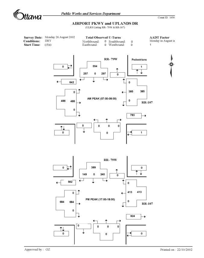
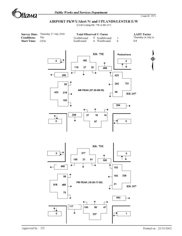
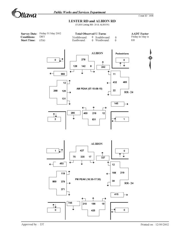

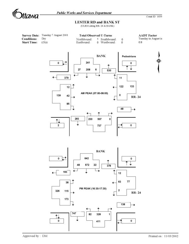
Document 3
Transportation
and Transit Committee Report 33 on 4 December 2002 and Minutes of Council
Meeting of 18 December 2002. See
the Document Link on Page 7 of this Report.
document 4
Transportation
Committee Report 8 on 2 June 2004 and Minutes of Council
Meeting
of 9 June 2004 (Including the Memo T08-01-ALBI from Deputy City
Manager,
Department of Public Works and Services to the Chair and Members,
Transportation
Committee) - See the Document Link on Page 7 of this Report.
DOCUMENT 45
Information
Package Distributed to the Public in the Spring of 2003
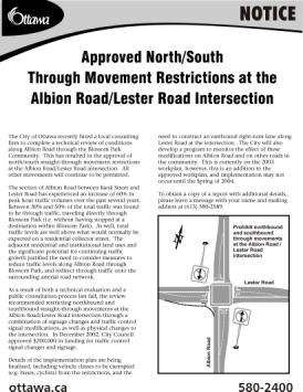
Albion Road Corridor Study
and
Approved North/South Through Movement
Restrictions
at the Albion Road at Lester Road Intersection
Executive Summary
The City of Ottawa recently hired a local consulting
firm to complete a technical review of conditions along Albion Road through the
Blossom Park Community (see Figure 1).
This has resulted in the approval of north/south straight-through
movement restrictions at the Albion Road/Lester Road intersection. All other movements will continue to be
permitted.
The section of Albion Road between Bank Street and
Lester Road has experienced an increase of 60% in peak hour traffic volumes
over the past several years. Between
30% and 50% of the total traffic was found to be through traffic, traveling
directly through Blossom Park (i.e. without having stopped at a destination
within Blossom Park). As well, total
traffic levels are well above what would normally be expected on a residential
collector street. The adjacent
residential and institutional land uses and the significant potential for
continuing traffic growth justified the need to consider measures to reduce
traffic levels along Albion Road through Blossom Park, and redirect through
traffic onto the surrounding arterial road network.
As a result of both a technical evaluation and a
public consultation process last fall, the study recommended restricting northbound and southbound straight-through movements at the
Albion Road/Lester Road intersection. Movements will be restricted through a
combination of signage changes and traffic control signal modifications, as
well as physical changes to the intersection.
In December 2002, Transportation and Transit Committee, and subsequently
City Council,
approved $200,000 in funding for traffic control signal changes and signage
(see Figure 2).
Details of the implementation plan are being finalized, including vehicle classes to be exempted (e.g. buses, cyclists) from the restrictions, and the need to construct an eastbound right-turn lane along Lester Road at the intersection. The City will also develop a program to monitor the effect of these modifications on Albion Road and on other roads in the community. This project is currently on the 2003 workplan, however, this is in addition to the approved workplan, and implementation may not occur until the Spring of 2004.
Purpose of Study and
Background
This study has been undertaken as a result of direction from City Council, in response to both new development proposals and longstanding concerns over traffic conditions along the residential collector section of Albion Road within the Blossom Park Community. Concerns had been raised about the potential impact of proposed new developments such as the Central Canada Exhibition relocation, increasing business at the Rideau Carleton Raceway, significant community developments to the south, and Canada Lands Company development proposals in the vicinity, as well as with concerns over current traffic conditions along Albion Road through Blossom Park.
Figure 1 – Location Plan
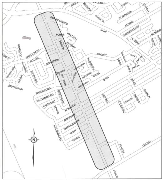
Figure 2 - Interim
Solution
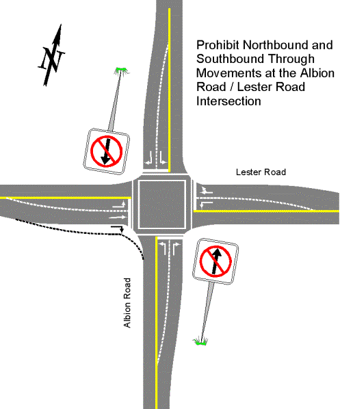
On 24 July 2002, City Council considered a report on the potential relocation of the Central Canada Exhibition to a new site near the intersection of Albion Road and Rideau Road. Following that decision, a motion was approved that required a focused Corridor Traffic Study to be undertaken immediately of Albion Road between Lester Road and Bank Street (see Figure 1), because of traffic concerns that had been raised regarding this section of Albion Road. Any decisions on the need for funding recommendations arising from this study were to be referred to the 2003 Budget process.
In order to respect Council’s direction to immediately undertake this study, and its direction to consider funding issues as part of the 2003 Budget process, it was necessary to report back to the Transportation and Transit Committee and Council on this study before the end of 2002. This resulted in a very compressed work schedule.
Of particular relevance to this study, Albion Road through Blossom Park is designated as a collector street, not an arterial street, suggesting the primary function of Albion Road should be to distribute traffic between the arterial street network and the Blossom Park Community local street network (Region of Ottawa-Carleton Transportation Master Plan – Map 3 – Future Urban Arterial Road Network). The arterial network serving the general area includes Albion Road south of Blossom Park, Lester Road, Bank Street, the Airport Parkway and Hunt Club Road. These arterials are intended to accommodate the needs of those traveling over longer distances, and also to accommodate higher volumes of traffic.
Issues Identified
The major community-related issues and concerns that were identified for the section of Albion Road between Bank Street and Lester Road included:
· Significant recent growth in both peak hour and daily traffic volumes;
· High proportion of through traffic traveling through the community;
· Traffic speeds on Albion Road;
· Safety concerns for pedestrians, cyclists and motor vehicles traveling on, or crossing, Albion Road; and,
· Potential for further traffic increases in Blossom Park due to continued urban development.
Existing Traffic Conditions
The combination of relatively high traffic levels using Albion Road through Blossom Park, a significant increase in these levels over the past few years, the relatively high percentage of this traffic that is through traffic, and the presence of arterial street alternatives to Albion Road provided justification for considering measures to reduce traffic levels along Albion Road through Blossom Park, and redirect through traffic onto the surrounding arterial network.
Traffic Volumes
Traffic volumes on Albion Road between Bank Street and Lester Road have increased significantly since the summer of 2000, the last time that traffic volume data was collected for this area. Prior to 2000, traffic volumes were stable, after experiencing some decline following the completion of the Hunt Club Road/Airport Parkway interchange and the extension of Lester Road to connect to the Airport Parkway/Uplands Drive intersection.
Daily traffic volumes between 2000 and 2002 have increased by 35% immediately north of Lester Road, and by 15% immediately south of Bank Street. Peak hour volumes have increased by 60% immediately north of Lester Road. Morning and afternoon peak hour volumes are currently in the range of 500 to 825 vehicles per hour (two-way) immediately north of Lester Road, and between 675 and 1,050 vehicles per hour immediately south of Bank Street.
Also of note, traffic volumes were found to be relatively heavy throughout the day, not just during the commuter peak periods, extending well into late evening and early morning periods. Traffic destined to/from the Rideau Carleton Raceway is assumed to be a significant component of this activity.
Traffic Speeds
The average speed of traffic along Albion Road, based on data collected at three separate survey locations, was found to be approximately 60 km/h, or 10 km/h over the posted speed limit. The 85th percentile speed (the speed at or below which 85 percent of traffic travels) was found to be 68 km/h.
Through Traffic
As input to the technical review, the City conducted origin-destination (O-D) surveys to determine through traffic volume levels traveling directly through this community, during both August and September 2002. License plate information was recorded and matched for vehicles entering and exiting Albion Road at both Bank Street and Lester Road during morning and afternoon peak travel periods. This is how through traffic was identified. Also included were right-turn movements from Hunt Club Road onto Bridle Path Drive, and left-turn movements from Bridle Path Drive to Hunt Club Road. Based on the matching of license plates, the magnitude of two-way through traffic on Albion Road through Blossom Park was estimated to be in the order of 200 and 385 vehicles per hour in the morning and afternoon peak hours, respectively. Expressed as a percentage of total traffic, between 29% and 47% was classified as through traffic. These through traffic details are summarized in Table 1.
Table 1 - Through Traffic – Albion Road
(Two-way)
|
Location |
AM Peak Hour |
PM Peak Hour |
|
Immediately South of Bank Street |
29% (200 / 680 vehicles) |
36% (385 / 1060 vehicles) |
|
Immediately North of Lester Road |
40% (200 / 500 vehicles) |
47% (385 / 820 vehicles) |
The most substantial movements for non-local
traffic were the northbound and southbound straight-through movements at the Albion
Road/Lester Road intersection. Of the
total peak hour through traffic using Albion Road through Blossom Park, between
83% and 96% were recorded traveling north/south directly through the Lester
Road/Albion Road intersection.
Approximately 45% to 65% of the north/south straight-through movements
at this intersection were found to be through traffic that traveled directly
through Blossom Park.
Putting Current Conditions into Perspective
While current traffic volumes, traffic speeds and through traffic levels were all of concern to Blossom Park residents, volumes and through traffic levels, in particular, are considered to be unusually high for a residential community collector street. To help put this into perspective, Table 2 provides comparative traffic volumes along various City streets in Blossom Park and surrounding communities.
Table 2 - Comparative Traffic Volumes Along Area Streets
Street Name
|
Street Classification |
Peak Hour Traffic Volume
(veh/hr) |
|
|
AM Peak Hour |
PM Peak Hour |
||
|
Albion Road south of Bank Street |
Collector |
700 |
1050 |
|
Alta Vista Drive east of Bank Street |
Collector |
1150 |
1200 |
|
Blohm Drive north of Hunt Club Road |
Collector |
350 |
450 |
|
Cahill Drive east of Bank Street |
Collector |
250 |
350 |
|
D’Aoust Avenue west of Bank Street |
Collector |
200 |
150 |
|
Johnston Road east of Bank Street |
Collector |
600 |
650 |
|
Kilborn Avenue east of Bank Street |
Collector |
550 |
700 |
|
Lorry Greenberg Drive west of Conroy Road |
Collector |
550 |
450 |
|
McCarthy Road south of Walkley Road |
Collector |
600 |
800 |
|
Pleasant Park Road east of Riverside Drive |
Collector |
350 |
350 |
|
Uplands Drive east of Riverside Drive |
Collector |
600 |
600 |
|
|
|
|
|
|
Queensdale Avenue west of Bank Street |
Local |
200 |
450 |
|
Rosebella Avenue west of Bank Street |
Local |
25 |
50 |
|
|
|
|
|
|
Airport Parkway north of Hunt Club Road |
Arterial |
2550 |
2800 |
Bank Street south of Albion Road
|
Arterial |
1500 |
1900 |
|
Bank Street north of Lester Road |
Arterial |
800 |
1000 |
|
Conroy Road south of Hunt Club Road |
Arterial |
750 |
750 |
|
Conroy Road north of Hunt Club Road |
Arterial |
1050 |
1400 |
|
Lester Road east of Albion Road |
Arterial |
600 |
650 |
|
Russell Road north of Walkley Road |
Arterial |
1050 |
1250 |
As Table 2 shows, current traffic volumes along
Albion Road, while not necessarily unique, are certainly well above the norm
for residential collector streets.
These volumes, when considered in conjunction with the relatively high
proportion of through traffic, provided justification for considering measures
that would reduce through traffic levels using the residential collector
section of Albion Road, through Blossom Park.
When considering the appropriateness of restricting traffic levels along a residential street, it is worth also noting that volume levels represent only a part of the overall picture. Even when volume levels are considered excessive, if this traffic is essentially only local or community traffic, as opposed to through traffic, options for removing this traffic are usually limited, at best. Also, even if a significant component of this traffic is through traffic, consideration must also be given to available alternatives for accommodating it. In the case of Albion Road, the combination of both current volumes and through traffic, and the availability of alternatives (Lester Road connecting to both the Airport Parkway and Bank Street), suggests there to be a reasonable opportunity to consider traffic restrictions.
Potential Traffic Increases
Due to Proposed Area Developments
A number of development proposals are in various stages of planning both within Blossom Park and on lands to the south, which could potentially generate significant additional traffic along Albion Road. Some of the more significant development proposals include:
- Potential Central Canada Exhibition relocation to lands at the corner of Rideau Road and Albion Road, with weekday and Saturday peak hour projections of an additional 160 to 270 vehicles per hour using Albion Road through Blossom Park;
- Canada Lands Company residential developments (two separate parcels) located within Blossom Park, on former NRC lands southeast of the Albion Road and Queensdale Avenue intersection, with potentially 250 additional peak hour vehicle trips along Albion Road. This would be considered as new local community traffic, as opposed to through traffic; and,
- Riverside South and Findlay Creek communities, which, according to the City’s Transportation Master Plan assumptions, could generate in the order of 7,500 new vehicle trips during the afternoon peak hour by the year 2021. Projections of the potential for these vehicle trips to make use of Albion Road are not available, and to a large extent will depend on the timing of other transportation facilities planned for this general area.
The combination of any or all of these developments would almost certainly result in continued traffic volume increases (particularly non-local traffic) along Albion Road, suggesting the need to not only address existing conditions, but also to consider measures to mitigate against these potential increases.
Evaluation of Potential Mitigation Measures
A number of mitigation alternatives were
developed that would potentially limit through traffic through Blossom
Park.
Since both traffic volumes and through traffic were found to be at issue, the mitigation alternatives involved restrictions to entering or exiting the Blossom Park community, and in particular to those that were likely to be effective in reducing through traffic while at the same time minimizing impacts to community residents or to those who had specific destinations within the community.
The list of alternative measures did not include traffic calming measures, such as speed humps. Such measures are generally intended as a means of affecting driver speeds and behaviour, as opposed to reducing traffic volumes. Traffic calming measures are unlikely to address the volume and through traffic issues that are of concern to the community.
The following
mitigation alternatives were developed and evaluated, and were presented to the
public at a Public Open House on 14 November 2002:
· Prohibiting northbound and southbound through movements at the Albion Road at Lester Road intersection;
· Restricting the north leg of the Albion Road at Lester Road intersection to only right-in, right-out movements;
· Constructing a cul-de-sac on the north leg of the Albion Road at Lester Road intersection;
· Re-aligning the Albion Road at Lester Road intersection to redirect travel patterns;
· Prohibiting northbound left turns and eastbound right turns at the Albion Road at Bank Street intersection;
· Prohibiting northbound and southbound through movements at the Albion Road at Bank Street intersection; and,
· Prohibiting eastbound right-turn and northbound left-turn movements at the Hunt Club Road at Bridle Path Drive intersection.
The evaluation of these alternatives considered:
· Potential to remove through traffic from along Albion Road through Blossom Park
· Potential reductions in peak hour traffic
· Potential to avoid diverting traffic onto other Blossom Park streets
· Impacts on transit, school buses and emergency services
· Measure effectiveness / enforcement required
· Accommodation of pedestrian and cyclists, and
· Relative construction costs
Of the
alternatives evaluated, prohibiting northbound and southbound
through movements at the Albion Road at Lester Road intersection was found to
be the most appropriate, as these two movements made up between 85% and 95% of
the total through traffic activity, and was found to have the least impact with
respect to maintaining overall community accessibility.
Recommended
Alternative
The recommended mitigation measure,
as a result of this review, is to restrict northbound and southbound
straight-through movements at the Albion Road at Lester Road intersection,
through a combination of physical changes to the intersection, as well as
signage and traffic control signal changes.
All other movements at this intersection would continue to be permitted.
This recommended alternative, as shown in Figure 3, would:
·
Reduce
peak hour traffic by 170 to 360 vehicles per hour in the morning peak and by
320 to 530 vehicles per hour in the afternoon peak;
· Result in a diversion of between 60 and 180 vehicles per hour in the morning peak and between 90 and 265 vehicles per hour in the afternoon peak onto the local street system (mix of local and non-local traffic). This will be spread out between all the existing streets that provide exits to the community;
· Have the least impact on community accessibility, and,
· Be designed to accommodate transit, emergency vehicles, pedestrians and cyclist access, to the extent practical.
Figure 3 - Recommended Alternative
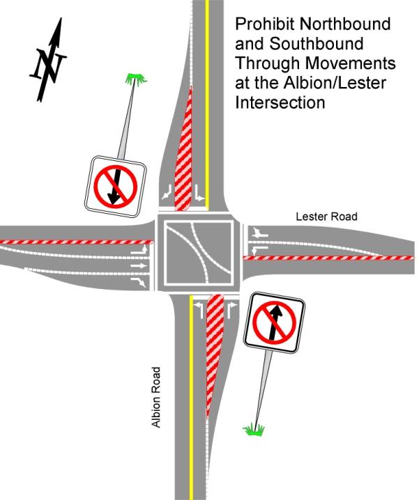
The implementation of this alternative
will have implications for various road users beyond simply those traveling
directly through Blossom Park. In
particular, residents living south of Lester Road wishing to access facilities
within Blossom Park, as well as residents of Blossom Park wishing to access
areas to the south of Lester Road, will also be affected. While these groups are seen as legitimate
users of the direct Albion Road connection, there is no means for the City to
provide an exemption from the restrictions as the only exemptions possible, in
accordance with the Ontario Highway Traffic Act, are for certain types
of vehicles such as transit vehicles or cyclists.
Given the magnitude of traffic
affected by the proposed restrictions, the recommended alternative presented to
Transportation and Transit Committee included the realignment and
channelization of traffic lanes to prevent north-south through movements on
Albion Road and the construction of an eastbound right-turn lane to accommodate
diverted traffic to Lester Road. A
preliminary cost estimate for these modifications totalled approximately
$1.7M. Also identified was the potential
need for traffic control signals at the two Airport Parkway ramp intersections
with Lester Road. Significant impacts
to the arterial road network are not anticipated, either south of Lester Road
or north of Hunt Club Road.
Short Term
Solution
In light of the substantial costs ($1.7M)
associated with the recommended alternative, a lower cost short term derivative
was brought forward for consideration.
This solution involves restricting north/south through movements with
only traffic control signal changes and signage. Transportation and Transit Committee and City Council approved
$200,000 in funding for this solution that can be implemented in the short
term. Funding for the physical changes
associated with the full recommended alternative may be considered in future
years.
It is noted, however, that such an option
is likely to result in lower compliance levels and an on-going need for more
enforcement, and may limit the ability to provide exemptions to transit, school
buses and emergency vehicles.
Consideration is still being given to the construction of the eastbound right-turn lane along Lester Road approaching Albion Road. This additional lane had previously been identified as a potential requirement when the addition of slot machines at the Rideau Carleton Raceway was approved. Work done as part of the Albion Road Corridor Study suggests that current conditions warrant this lane being constructed. Traffic levels at the two Airport Parkway ramp intersections with Lester Road will be monitored to determine if minimum warrants for signals have been achieved. If warrants are achieved, traffic control signals will be installed once funding becomes available through the Traffic Control Signal Installation Program.
Public Consultation
A number of opportunities for public input were provided as part of the Albion Road Corridor Study over the past several months. Through this process, the majority of those who commented indicated their support for the recommended alternative.
The opportunities for public comment included a community meeting for Blossom Park residents of Albion Road, a Public Open House for all Blossom Park residents, and the presentation of this study to Transportation and Transit Committee on 4 December 2002, a Standing Committee of City Council, and to Transportation and Transit Committee budget deliberations on 10 December 2002. In addition, the recommendations endorsed by Transportation and Transit Committee then proceeded to full City Council for final approval, both at a regular meeting on 18 December 2002, and at the City Council budget approval meeting on 8 January 2003.
The community meeting, which was intended as a means of discussing traffic concerns of Albion Road residents, was held on 26 September 2002. This meeting provided the consultant and staff with an understanding of the current issues and concerns along this street.
A Public Open House, to present the preliminary findings of the Albion Road Corridor Study, was held on 14 November 2002 at Blossom Park Public School. Notices for this Open House were hand delivered to all residents and businesses in Blossom Park, west of Bank Street, as per the request of Councillor Diane Deans. As well, a notice appeared in the community paper for this area (Greenboro-Hunt Club edition of The News), and an article appeared in the Ward Councillor’s bi-weekly column in the community newspaper. Approximately 85 people attended the Public Open House. Based on the formal comment sheets returned, the following comments were noted:
· 66% of respondents supported the recommended alternative
· 22% did not indicate a strong preference for any of the alternatives
· 12% opposed the recommended alternative or preferred another alternative
Attendees at the Public Open House were made aware that this issue was scheduled for consideration by the Transportation and Transit Committee, on 4 December 2002. The Transportation and Transit Committee agenda was also published in the Ottawa Citizen, the Ottawa Sun, and Le Droit, on the Friday preceding the meeting, as is standard practice.
In addition, through the City’s notification of the 4 December 2002 Transportation and Transit Committee agenda, additional comments were received. The Airport Authority indicated concerns over the potential impact of the proposed changes in traffic patterns on the Airport Parkway. A downtown citizen’s group, “The City Centre Coalition”, indicated concerns over the potential impacts on both the Airport Parkway and Bronson Avenue. As well, a resident of Riverside South indicated concerns over the additional travel times that would be required for those living to the south. Members of Transportation and Transit Committee were made aware of these additional concerns, along with an indication from staff that in their opinion these implications were both reasonable and manageable.
Next Steps
Based on City Council’s approval of $200,000 in funding for the short-term solution, the Transportation, Utilities and Public Works Department will proceed with implementation. Several details still need to be finalized, including the details of traffic control signal changes required, classes of vehicles that could be exempted, and the need to construct the eastbound right-turn lane along Lester Road at the Albion Road intersection. While it is the Department’s intention to install the approved restrictions as early as possible, this implementation may be delayed depending on the time requirements for resolving some of these details. As this project is an addition to the Transportation, Utilities and Public Works Department’s approved 2003 workplan, implementation may not occur until the Spring of 2004.
Monitoring and Evaluation Program
As part of the implementation of the approved short-term solution, the Transportation, Utilities and Public Works Department will be undertaking a monitoring and evaluation program, to monitor the effectiveness of the restrictions that are put into place. This will include a before-and-after volume and speed survey on surrounding arterial and collector streets, as well as all connecting streets leading from Blossom Park onto Bank Street or Lester Road.
Of note, while minor modifications may be possible, major modifications if required may need to be considered as a future project.