|
1. ZONING - 20 FRANK
NIGHBOR PLACE ZONAGE - 20, PLACE FRANK NIGHBOR |
Committee recommendation as
amended
(This application is not subject to Bill 51)
That Council approve an amendment to the former City of Kanata Zoning
By-law 138-93 to change the zoning of 20 Frank Nighbor Place from
"M1C-2(H)-f" (Light Industrial, Mixed, Exception 2, Holding (Flood
Fringe)) to "M1C-XX(H)-f" (Light Industrial, Mixed, Exception,
Holding (Flood Fringe)), as shown in Document 1 and detailed in Documents 4 and
5, as amended by the following:
·
That Restaurant, Fast-Food; Restaurant, Full-Service; and Restaurant,
Take-Out be added to subclause 2(a)(i)(1) as additional permitted uses with no
drive-through facility.
·
That
garden centres must be 0.3 metres above regulatory flood levels.
Recommandation MODIFIéE du comité
(Cette demande n’est
pas assujettie au Règlement 51)
Que le Conseil municipal approuve
une modification du Règlement de zonage no 138-93 de l’ancienne Ville de Kanata
afin de faire passer le zonage du 20, place Frank Nighbor, de « M1C-2(H)-f »
(zone d'industrie légère, utilisations mixtes, exception 2, utilisation
différée [périmètre d’inondation]) à « M1C-XX(H)-f » (zone d'industrie légère,
utilisations mixtes, exception, utilisation différée [périmètre d’inondation]),
comme l’indique le document 1 et le précisent les documents 4 et 5, tels que
modifiés par ce qui suit :
·
l’inclusion de restaurant-minute, de restaurant à service complet et de comptoir de commandes à emporter comme utilisations supplémentaires permises, sans service à l’auto ;
·
les
jardineries devront être à 0,3 mètres au-dessus des niveaux de crue réglementaires.
Documentation
1.
Deputy
City Manager's report Planning, Transit
and the Environment dated
25 September 2007 (ACS2007-PTE-APR-0158).
2.
Extract
of Draft Minutes, 9 October 2007.
Report to/Rapport au :
Planning and Environment Committee
Comité de l'urbanisme et de l'environnement
and Council / et au Conseil
25 September 2007 / le 25 septembre 2007
Submitted
by/Soumis par : Nancy Schepers, Deputy City Manager /
Directrice municipale adjointe,
Planning, Transit and the Environment /
Urbanisme, Transport en commun et Environnement
Contact
Person/Personne Ressource : Grant Lindsay, Manager / Gestionnaire,
Development Approvals / Approbation des demandes d'aménagement
(613)
580-2424, 13242 Grant.Lindsay@ottawa.ca
|
SUBJECT: |
|
|
|
|
|
OBJET : |
REPORT RECOMMENDATION
That the Planning and Environment Committee recommend that Council approve an amendment to the former City of Kanata Zoning By-law 138-93 to change the zoning of 20 Frank Nighbor Place from "M1C-2(H)-f" (Light Industrial, Mixed, Exception 2, Holding (Flood Fringe)) to "M1C-XX(H)-f" (Light Industrial, Mixed, Exception, Holding (Flood Fringe)), as shown in Document 1 and detailed in Documents 4 and 5.
RECOMMANDATION DU RAPPORT
Que le Comité de l’urbanisme et de l’environnement
recommande au Conseil d’approuver une modification du Règlement de zonage no
138-93 de l’ancienne Ville de Kanata afin de faire passer le zonage du 20,
place Frank Nighbor, de « M1C-2(H)-f » (zone d'industrie légère, utilisations
mixtes, exception 2, utilisation différée [périmètre d’inondation]) à
« M1C-XX(H)-f » (zone d'industrie légère, utilisations mixtes, exception,
utilisation différée [périmètre d’inondation]), comme l’indique le document 1
et le précisent les documents 4 et 5.
EXECUTIVE SUMMARY
Assumptions and Analysis:
20 Frank Nighbor Place is located
within the Terry Fox Business Park. The
7.8-hectare site is undeveloped and is bounded by Highway 417 to the north, a
Home Depot store to the east, an office building to the south, and the Carp
River to the west. The western portion
of the site is located within the regulatory flood line for the Carp
River.
The applicant proposes to develop
the site with a shopping centre containing a total floor area of approximately
19772 square metres. Potential tenants
for the shopping centre include a
department store with a floor area of approximately 10000 square metres;
two retail warehouses each with a floor area in the range of 2600 to 2800
square metres; and smaller retail and service commercial uses. Frank Nighbor Place and Silver Seven Road
will provide vehicular access between the site and Palladium Drive, which is
part of the City’s arterial road network.
The majority of the site is zoned
“M1C-2(H)-f” (Light Industrial, Mixed, Exception 2, Holding (Flood Fringe)),
which permits a range of light industrial and commercial uses including
offices, business park retail outlets, home renovation centres, hotels,
offices, planned retail centres, retail warehouses, automobile sales
dealerships and restaurants. A retail
warehouse use, which has a minimum gross floor area of 1858 square metres and a
maximum gross floor area of 4999 square metres, is only permitted after the
holding (H) symbol has been lifted. The
conditions to lift the holding symbol include the submission of a traffic
study, a market study, a site plan application, and any other information
required by the City. The flood plain
"f" symbol requires all permitted uses to be flood proofed.
The west side of the site is
zoned “H” (Hazard), which permits a range of non-residential uses including
conservation, bird sanctuaries, wildlife reserves, flood and erosion control
works, and an at grade parking area, subject to the approval of Mississippi
Valley Conservation and site plan control approval.
The
applicant is applying for a site-specific Zoning By-law amendment to add a
department store, retail stores and a shopping centre as permitted uses.
The subject property is designated “Employment Area” and “Major Open Space” in the Official Plan. The Employment Area policies allow retail uses on the subject property provided that adequate road capacity is available. The Ontario Municipal Board has determined that the existing road network can provide adequate road capacity subject to the implementation of roadway modifications on Frank Nighbor Place and Silver Seven Road and at the Palladium Drive/Silver Seven Road intersection. The recommendation is to rezone part of the subject property from “M1C-2(H)-f” to a new, site-specific “M1C-XX(H)-f” (Light Industrial, Mixed, Exception, Holding (Flood Fringe)) zone. The portion of the site zoned “H” (Hazard) for the Carp River floodway will not be rezoned. The conditions associated with the holding symbol (H) have been modified to ensure that the required roadway modifications will be implemented prior to permitting a department store, a planned retail centre, a retail store, a retail warehouse and a shopping centre. The proposed uses comply with the applicable Official Plan policies. The proposed shopping centre will complement the existing Home Depot and Costco stores located east of the site, and further establish this area as a regional shopping node.
Financial Implications:
No costs are anticipated to be incurred by the City.
Public
Consultation/Input:
There were no public comments received in opposition to the application.
RÉSUMÉ
Hypothèses et analyse
Sis au 20 de la place Frank Nighbor, le
bien-fonds se trouve dans le parc d’affaires Terry Fox. Il a une superficie de
7,8 hectares, n’est pas aménagé et est délimité au nord par l'autoroute
417, à l’est par un magasin Home Depot, au sud par un immeuble de bureaux et à
l’ouest par la rivière Carp. La partie la plus à l’ouest du bien-fonds est
définie par la limite d’inondation réglementaire de la rivière Carp.
Le requérant désire construire sur le terrain
un centre commercial dont la surface de plancher totale serait d’environ
19 772 mètres carrés. Le centre commercial aurait pour locataires
potentiels un grand magasin ayant une surface de plancher approximative de
10 000 mètres carrés, deux entrepôts de vente au détail qui auraient chacun
une surface de plancher de 2 600 à 2 800 mètres carrés ainsi que
de petits commerces de service et de vente au détail. La place Frank Nighbor et
le chemin Silver Seven serviraient de voies de circulation entre le bien‑fonds
et la promenade Palladium, laquelle fait partie du réseau artériel municipal
d’Ottawa.
Le zonage actuel de la majeure partie du
bien-fonds est « M1C-2(H)-f » (zone d'industrie légère, utilisations
mixtes, exception 2, utilisation différée [périmètre d’inondation]), ce qui
permet un éventail d’utilisations commerciales et d’industries légères, comme
les immeubles de bureaux, les commerces de détail dans un parc d’affaires, les
centres de rénovation, les hôtels, les centres de vente au détail projetés, les
entrepôts de vente au détail, les concessionnaires d’automobiles et les
restaurants. Les entrepôts de vente au détail, qui ont une surface de plancher
hors oeuvre brute d’au moins 1 858 mètres carrés et d’au plus
4 999 mètres carrés, ne sont permis que si l’utilisation différée (H)
est levée. Pour qu’une utilisation différée soit levée, il faut soumettre à la
Ville une étude de la circulation, une étude de marché, une demande de plan
d'implantation et toute autre information exigée. Lorsqu’un bien-fonds porte la
mention de plaine inondable (f), toutes les utilisations permises doivent
offrir une protection contre les inondations.
Le zonage de la partie ouest du bien-fonds est
« H » (terres dangereuses), ce qui permet une gamme d’utilisations
non résidentielles, comme les zones de protection de la nature, les refuges
d’oiseaux, les réserves fauniques, les ouvrages de contrôle des inondations et
de l’érosion et un terrain de stationnement de surface, sous réserve de
l’approbation de l’Office de protection de la nature de la vallée du
Mississippi et de la réglementation du plan d’implantation.
Le requérant demande l'approbation
d’une modification ponctuelle du Règlement de zonage qui ajouterait les grands
magasins, les commerces de vente au détail et les centres commerciaux aux utilisations
permises sur le bien-fonds en question.
La propriété visée est désignée « secteur
d’emploi » et « espace libre d’importance » dans le Plan
officiel de la Ville d’Ottawa. Les politiques relatives au secteur d’emploi
permettent les utilisations de vente au détail sur le bien-fonds en question, à
condition que le réseau routier soit en mesure d’absorber la circulation
connexe. La Commission des affaires municipales de l’Ontario a déterminé que le
réseau routier actuel peut recevoir la circulation connexe si des modifications
sont apportées à la chaussée de la place Frank Nighbor et du chemin Silver
Seven ainsi qu’à l’intersection de la promenade Palladium et du chemin Silver
Seven. La présente recommandation vise à faire passer le zonage d’une partie du
bien-fonds visé de « M1C-2(H)-f » à « M1C-XX(H)-f » (zone
d'industrie légère, utilisations mixtes, exception, utilisation différée
[périmètre d’inondation]). La partie du bien-fonds dont le zonage est
« H » (terres dangereuses), qui correspond à la plaine inondable
située aux abords de la rivière Carp, ne fera pas l’objet d’une modification de
zonage. Les conditions associées à la lettre H (utilisation différée) ont
été changées de manière à ce que les travaux de réfection de la chaussée
nécessaires soient réalisés avant qu’un grand magasin, un centre de vente au
détail projeté, un commerce de détail, un entrepôt de vente au détail et un
centre commercial soient autorisés sur la propriété visée. Les utilisations
proposées sont conformes aux politiques pertinentes du Plan officiel. Le centre
commercial servirait de complément aux magasins Home Depot et Costco qui se
trouvent actuellement à l’est du bien-fonds et contribuerait à faire de ce
secteur un noyau commercial régional plus établi.
Répercussions financières
La présente recommandation n’a aucune
répercussion financière pour la Ville.
Consultation publique/commentaires
Aucun membre du public n’a exprimé
son opposition à la présente recommandation.
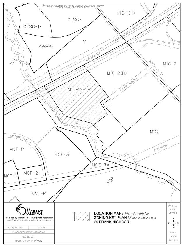
BACKGROUND
20
Frank Nighbor Place is located within the Terry Fox Business Park, as shown in
Document 1. The 7.8-hectare site is
undeveloped and is bounded by Highway 417 to the north, a Home Depot store to
the east, an office building to the south, and the Carp River to the west. The western portion of the site is located
within the regulatory flood line for the Carp River.
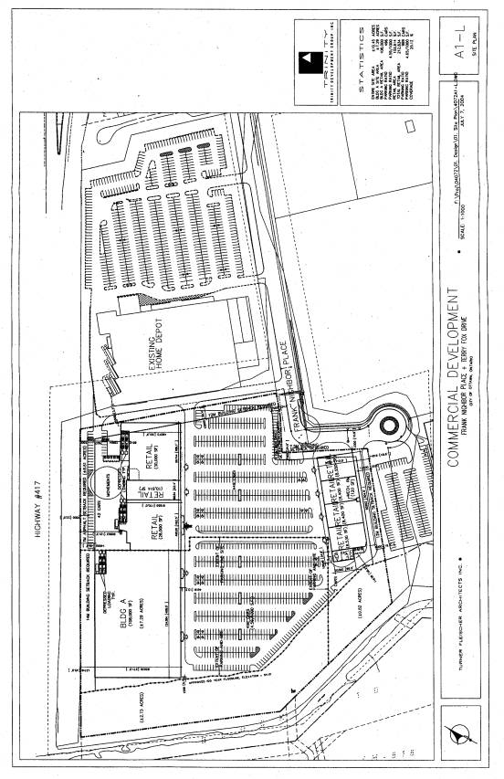
Proposed Development
The applicant proposes to develop
the site with a shopping centre containing a total floor area of approximately
19772 square metres. A conceptual site
plan is shown in Document 2. Potential
tenants for the shopping centre include a department store with a floor area of
approximately 10000 square metres; two retail warehouses each with a floor area
in the range of 2600 to 2800 square metres; and smaller retail and service
commercial uses.
Frank Nighbor Place and Silver
Seven Road will provide vehicular access between the site and Palladium Drive,
which is part of the City's arterial road network.
Existing Zoning
The majority of the site is zoned
"M1C-2(H)-f" (Light Industrial, Mixed, Exception 2, Holding (Flood
Fringe)). The west side of the site is
zoned "H" (Hazard).
The "M1C-2(H)-f" zone
permits a range of light industrial and commercial uses including offices,
business park retail outlets, home renovation centres, hotels, offices, planned
retail centres, retail warehouses, automobile sales dealerships and
restaurants. A retail warehouse use,
which has a minimum gross floor area of 1858 square metres and a maximum gross
floor area of 4999 square metres, is only permitted after the holding (H)
symbol has been lifted. The conditions
to lift the holding symbol include the submission of a traffic study, a market
study, a site plan application, and any other information required by the City. The flood plain "f" symbol
requires all permitted uses to be flood proofed.
The "H" zone permits a
range of non-residential uses including conservation, bird sanctuaries,
wildlife reserves, flood and erosion control works, and an at grade parking area,
subject to the approval of Mississippi Valley Conservation and site plan
control approval.
The existing zoning was
implemented through a Zoning By-law amendment in 2002 (Report Reference No. ACS2002-DEV-APR-0128). The amendment was based on an analysis
of the Carp River system and the potential for a two-zone flood plain for the
reach from Richardson Side Road to the Glen Cairn Detention Pond. The findings of the analysis indicated that
a two-zone approach could be applied to the subject property and to the
adjacent property to the south at 50 Frank Nighbor Place.
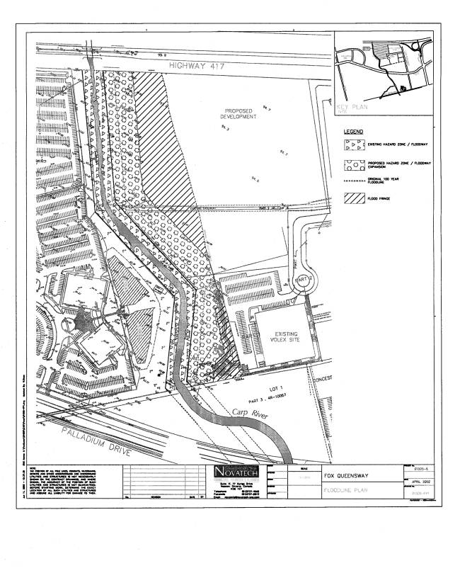
A two-zone approach establishes a
floodway, which is defined as the area within a flood plain where depths and
velocities of flood waters make development unsafe, and a flood fringe, which
is defined as the area within a flood plain where depths and velocities of
flood waters can be safely overcome and development may occur, subject to the
implementation of flood proofing measures.
The existing "H" zone corresponds with the Carp River floodway. The western portion of the
"M1C-2(H)-f" zone is located within the flood fringe area. The extent of the flood fringe area is shown
in Document 3.
Proposed Zoning
The applicant is applying for a
site-specific Zoning By-law amendment to add a department store, retail stores
and a shopping centre as permitted uses.
Specifically, the applicant has requested zoning to permit retail stores
with a gross floor area of less than 1858 square metres.
In April 2006, the applicant
appealed the subject application to the Ontario Municipal Board because the
City refused to make a decision on the application within the prescribed
timeframe under the Planning Act.
A hearing has not been scheduled
to date for the application. However, a
separate hearing was held in 2006 for a nearby property at 15 Frank Nighbor
Place and 737 and 777 Silver Seven Road.
Traffic issues that relate to the proposed development at 20 Frank
Nighbor Place were examined at this hearing.
DISCUSSION
The
site is located within the Terry Fox Business Park, which is designated as an
"Employment Area" in the Official Plan. The Carp River corridor is designated as "Major Open
Space".
Employment
Area Designation
The
Terry Fox Business Park is bounded by Highway 417 to the north, Terry Fox Drive
to the east, Maple Grove Road to the south and the Carp River to the west. Employment Areas are planned to provide at
least 2000 jobs at a range of densities.
Permitted uses include a variety of industrial and employment-generating
uses, such as warehousing and distribution, manufacturing, communications,
storage, construction, office, institutional, and research and development
uses. Complementary uses, such as
recreational, health and fitness uses, child care and service commercial uses
are also permitted.
Policy 3.6.5(g) in the Official Plan specifically permits retail
uses on lands located south of Highway 417, west of Terry Fox Drive, east of
the Carp River and north of Palladium Drive, save and except for property with
any frontage on Palladium Drive, and provided that adequate road capacity is
available. This policy recognizes that
the former City of Kanata Official Plan permitted limited retail uses within part
of the Terry Fox Business Park. As the
subject property is located within the geographic area described in the policy,
retail uses are permitted provided that adequate road capacity is
available. The Official Plan does not
contain any restrictions on the type of retail uses permitted, and does not
provide any minimum or maximum sizes for retail uses in this area.
Road
Capacity
The
issue of road capacity in the Terry Fox Business Park was examined at an
Ontario Municipal Board hearing in 2006 regarding appeals to four planning
applications at 15 Frank Nighbor Place and 737 and 777 Silver Seven Road. These properties are located on the south
side of Frank Nighbor Place across from Home Depot. The appeals were to two minor variance applications, an
application to lift the holding symbol from the existing "M1C-2(H)"
zone to permit retail warehouse uses, and a site plan application to permit
12167 square metres of retail and service commercial space.
One of the conditions to lift the holding symbol was for the proponent to submit a traffic study identifying the roadway/intersection modifications required to support the scale of development proposed. Existing retail developments in the area include a Home Depot store with a floor area of 11891 square metres and a Costco store with a floor area of 13311 square metres.
In addition, a Zoning By-law amendment application has been submitted to permit approximately 8175 square metres of retail uses at 720 Silver Seven Road, which is located immediately south of the Costco store. In total, there is upwards of 65000 square metres of existing and proposed retail commercial space in the vicinity of the subject site including the proposed shopping centre at 20 Frank Nighbor Place. In terms of scale, the existing and proposed developments would form one of the larger retail nodes within the city.
Silver Seven Road provides the only access between Palladium Drive and the existing and proposed retail developments. There is no other access between the developments and the arterial road network. The hearing focused primarily on the ability of the road network to accommodate all of the existing and proposed retail developments in the Terry Fox Business Park, and whether a single access was appropriate to support the scale of development.
The City argued that a single access is not sufficient to accommodate all of the retail and service commercial space proposed, and that the applications should not be approved until a second access can be provided. The developers argued that the road network could support all of the existing and proposed developments without the addition of a second access.
The Board issued a decision that supports all of the proposed retail and service commercial space proceeding with a single access. In particular, it was found that the intersection of Palladium Drive and Silver Seven Road will operate with a volume to capacity ratio of 0.9 during the peak hour and will meet the City's transportation criteria. The Board found that a second access is unnecessary. The Board's decision was predicated on roadway modifications being undertaken and the implementation of a cost-sharing agreement between the area landowners. The required modifications affect Silver Seven Road, Frank Nighbor Place and the Palladium Drive/Silver Seven Road intersection. After these roadway modifications have been implemented, there will be adequate road capacity available to support all of the existing and proposed retail developments. Accordingly, retail uses are permitted at 20 Frank Nighbor Place under Policy 3.6.5(g).
Employment
in the Terry Fox Business Park
As
discussed previously, there is a minimum employment requirement of at least
2000 jobs in the Official Plan for each Employment Area. The Department excludes retail jobs from the
employment calculations for the purpose of meeting the employment requirements
in Employment Areas.
According
to preliminary data from the 2006 Employment Survey, there were 2155 total jobs
in the Terry Fox Business Park in 2006 including full-time and part-time jobs. This figure includes 542 total jobs at Home
Depot and Costco, which are classified as retail jobs. When the retail jobs are excluded, there
were 1613 non-retail jobs in the Business Park in 2006. Since the survey was conducted, buildings
for EMS Satcom at 400 Maple Grove Road and Smart Technologies at 501 Palladium
Drive have been occupied adding approximately 681 non-retail jobs. In total, it is estimated that there are
approximately 2294 non-retail jobs in the Business Park, which exceeds the
minimum employment requirement in the Official Plan.
The
proposed shopping centre development will create up to 542 full-time equivalent
jobs.
Department
Store Use
While
the former City of Kanata Official Plan is no longer in force, the background
to Official Plan Amendment No. 46 to this Plan provides additional planning
context for the subject application. In
2000, the Ontario Municipal Board approved Amendment No. 46, which redesignated
the subject lands from "Restricted Industrial" (MR) to
"Restricted Industrial, Exception 3" (MR-3). The MR-3 designation added a limited range
of retail uses including a business park retail outlet, a retail warehouse, a
large retail warehouse of 5000 square metres or more, and a planned retail
warehouse consisting of two or more of the foregoing uses with a maximum
aggregate gross floor area of up to 35000 square metres per lot. The Amendment also contained specific
conditions to be met prior to permitting retail warehouses, large retail
warehouses and planned retail centres.
Official
Plan Amendment No. 46 was based in part on an Employment and Commercial Land
Use Study prepared by Malone Given Parsons Ltd. and FoTenn Consultants Inc.
dated November 1998. The study included
an analysis of commercial land use needs, which suggested that at least one and
possibly two new department stores could be warranted in Kanata in the
future. The study recommended that,
given the importance of the Kanata Town Centre and its role as a regional facility,
it is important that the next new department store be located in the
"Regional Shopping Centre" (RSC) designation in the Town Centre
unless it cannot be accommodated for whatever reason.
According
to the Kanata Town Centre Site-Specific Policies, which form part of the City
of Ottawa Official Plan, the RSC designation is intended to accommodate a full
range of commercial and other Town Centre activities and will include the
largest concentration of highest-order retail and service commercial uses in
the City of Kanata. The RSC designation
is bounded by Campeau Drive to the north, Kanata Avenue to the east, Highway
417 to the south and Terry Fox Drive to the west. Since the Employment and Commercial Land Use Study was completed,
development within the RSC designation has expanded to a total floor area of
over 86000 square metres. In
particular, the southern portion of the RSC designation was developed with a
Holiday Inn hotel and the Kanata Entertainment Centrum, which includes an AMC
cinema complex, Centrum Walk, and a variety of retail and service commercial
uses. The northern portion of the
designation is occupied by the Kanata Centrum Shopping Centre including a
Wal-Mart department store and a Loblaws supermarket.
Staff
reviewed the possibility of locating the proposed department store within the
RSC designation. However, the remaining
vacant land parcels do not possess a suitable size and configuration to
accommodate a second department store.
The only large vacant parcels of land are located on the south side of
Kanata Avenue between Earl Grey Drive and Lord Byng Way within the RSC-3
designation. This designation is
intended to be a high density employment area with the potential for
high-density residential uses and a limited amount of retail and service uses
on the ground floor. A department store
use is not permitted under the RSC-3 policies.
To
the east of the RSC designation is a large tract of vacant land that is
designated as "Central Business District" and "Main
Street". These designations are
intended to accommodate a significant concentration of employment uses in order
to achieve the minimum employment target of 12500 jobs in the Town Centre. This area is also planned to accommodate
1000 to 1500 dwelling units. The Kanata
Town Centre Site-Specific Policies do not contemplate a land-extensive retail
use such as a department store in these designations.
The
Employment and Commercial Land Use Study included a planning strategy for the
Terry Fox Business Park. It recommended
that this area be developed for both employment and retail, with retail focused
on the Highway 417 frontage between Terry Fox Drive and the Carp River, and
business employment uses planned for the remainder of the Business Park. Further, the planning strategy was to permit
large format retail uses on the Highway 417 frontage that are space extensive
and regionally oriented, but that would not compromise a possible future
regional shopping centre within the Town Centre. Therefore, the strategy was to prohibit department stores and
supermarkets, which often function as anchor stores for regional shopping
centres, from the Terry Fox Business Park.
This strategy is reflected in the existing "M1C-2(H)-f" zoning
of the subject property.
The
development of the proposed department store on the subject site will not
compromise the planned function of the Regional Shopping Centre. First, the RSC designation is already
anchored by a Wal-Mart department store and a Loblaws supermarket. Second, the RSC designation has reached a
sufficient size to firmly establish it as the dominant regional shopping centre
within the West Urban Area. Third, the
retail component of the RSC designation has been substantially built-out and
the remaining vacant land cannot accommodate another department store. The proposed shopping centre will satisfy
the demand for additional commercial space within the trade area that cannot be
accommodated within the RSC designation.
The
type of department store proposed by the applicant is considered to be a senior
or major department store, and the subject property at 20 Frank Nighbor Place
is a suitable location for this use.
The proposed department store would be the only senior department store
located west of Bayshore Shopping Centre within the city, and is expected to
attract customers from a large trade area.
The site provides high visibility from Highway 417 and a regionally
accessible location near the Highway 417 and Terry Fox Drive interchange. The site is located near a Home Depot store
and a Costco store, which are also regionally oriented retailers that attract
customers from large trade areas. The
addition of a new shopping centre anchored by a department store will
complement the Home Depot and Costco stores and further establish this node as
a regionally oriented shopping destination.
At
a larger scale, there are existing and proposed regional-scale retail
facilities at the northeast, northwest and southwest quadrants of the Highway
417 and Terry Fox Drive interchange.
The proposal to add additional regional-scale retail uses at 20 Frank
Nighbor Place reinforces this area as a regional shopping destination.
Retail
Store Use
The
applicant has proposed smaller retail uses with a gross floor area of less than
1858 square metres as a component of the shopping centre development. Smaller retail uses are typical of shopping
centres and often depend on the customer traffic that is initially generated by
an anchor tenant or by the shopping centre as a whole. The addition of smaller retail uses will
allow for a broader range of retail uses to be provided at the shopping centre,
and will complement the proposed department store and retail warehouse
uses. The proposed Zoning By-law
amendment to allow a department store and smaller retail uses will facilitate a
broader retail mix for the shopping centre and improve product selection,
choice and convenience for customers.
Compatibility
The
proposed shopping centre is compatible with existing and proposed development
in the area. In particular, it will have a similar built form to the existing
Costco and Home Depot developments on Frank Nighbor Place and Silver Seven
Road. There are no residential
developments located adjacent to the site that would be directly impacted by
the proposed shopping centre.
Market
Study
The
subject application was supported by a Retail Market Feasibility Study. Currently, there are no senior department
stores located within the primary trade area.
There are two junior department stores located within this area - one at
Kanata Centrum and one at Hazeldean Mall.
The Retail Market Feasibility Study demonstrated that the proposed
shopping centre, and especially the proposed senior department store, would
serve a strong unmet market demand. The
major existing retail facilities within the primary trade area, including
Kanata Centrum and Hazeldean Mall, do not have a major department store. Therefore, the proposed senior department
store should have a minimal impact on these facilities.
Major Open Space Designation
The
Major Open Space designation, which applies to the Carp River corridor, is
intended to protect the larger open spaces in Ottawa that are to be generally
available for public use and enjoyment.
The western portion of the site is located within the regulatory flood
plain for the Carp River. The portion
of the site zoned "H" corresponds with the Carp River floodway and
the Major Open Space designation. The
lands currently zoned "H" will be conveyed to the City as a condition
of a future site plan approval application.
Details of
Recommended Zoning
The proposed amendment will rezone part of the site from an “M1C-2(H)-f” zone to a new, site-specific “M1C-XX(H)-f” zone. The portion of the property that is zoned “H” is not affected by the proposed amendment. The details of the new zone are contained in Documents 4 and 5, and summarized below.
The proposed “M1C-XX(H)-f” zone will permit all of the uses allowed under the existing “M1C-2(H)-f” zone, and will add a department store, retail stores and a shopping centre as permitted uses. The proposed amendment will add definitions for a retail store and a shopping centre. New zoning provisions will be created for a department store, a planned retail centre, a retail store, a retail warehouse and a shopping centre including provisions for minimum yards, minimum required parking spaces, landscaping and maximum building height. The existing zoning restricts the density of retail warehouses and planned retail centres to a maximum gross floor area of 2298 square metres per development hectare. There is no longer any need to regulate the density of these uses for traffic or market impact reasons, and the proposed zoning will delete the density provisions.
The existing zoning has a holding symbol that requires the submission of a traffic study, a market study, a site plan application and any other information that the City may require, prior to permitting retail warehouse uses. These conditions to lift the holding symbol are no longer relevant. The Ontario Municipal Board has already accepted a traffic study supporting retail development on the site. A market study is no longer required because development in the Regional Shopping Centre designation exceeds a gross floor area of 50000 square metres. A condition to submit a site plan application is unnecessary as development of any of the permitted uses will require the submission and approval of a site plan application. Therefore, the Department recommends that the four conditions to permit a retail warehouse be deleted.
The Employment Area
policies only permit retail uses on the subject property if there is adequate
road capacity available. The Ontario
Municipal Board has identified the roadway modifications necessary to
accommodate all of the existing and proposed retail uses in the Terry Fox
Business Park. However, the
implementation details for the required roadway modifications remain
outstanding.
It is recommended
that a holding symbol be used to ensure that the roadway modifications will be
implement prior to permitting any retail uses including a department store, a
planned retail centre, a retail store, a retail warehouse and a shopping
centre. The conditions to lift the
holding symbol will be as follows:
a) The detailed design for the roadway modifications described in Exhibit 61 to the Ontario Municipal Board hearing regarding 15 Frank Nighbor Place and 737 and 777 Silver Seven Road (File Nos. PL051066, PL060317 and PL060318) has been approved by the City;
b) All necessary road widenings to accommodate the roadway modifications identified in subclause (a) above have been conveyed to the City;
c) A registered cost sharing agreement to construct the roadway modifications identified in subclause (a) above has been entered into between the owners of 15 Frank Nighbor Place, 20 Frank Nighbor Place, 720 Silver Seven Road, 737 Silver Seven Road and 777 Silver Seven Road, and provided to the City;
d) An implementation plan including a construction schedule for the roadway modifications identified in subclause (a) above has been provided to the City; and
e) A performance deposit has been provided to the City for the roadway modifications identified in subclause (a) above.
Prior to the lifting of the holding symbol, the permitted uses shall exclude a department store, a planned retail centre, a retail store, a retail warehouse and a shopping centre.
Conclusions
The subject property is designated “Employment Area” and “Major Open Space” in the Official Plan. The Employment Area policies allow retail uses on the subject property provided that adequate road capacity is available. The Ontario Municipal Board has determined that the existing road network can provide adequate road capacity subject to the implementation of roadway modifications on Frank Nighbor Place and Silver Seven Road and at the Palladium Drive/Silver Seven Road intersection. The recommendation is to rezone part of the subject property from “M1C-2(H)-f” (Light Industrial, Mixed, Exception 2, Holding (Flood Fringe)) to a new, site-specific “M1C-XX(H)-f” (Light Industrial, Mixed, Exception, Holding (Flood Fringe)) zone to add a department store, retail stores and a shopping centre as permitted uses. The portion of the site zoned “H” (Hazard) for the Carp River flood way will not be rezoned. The conditions associated with the holding symbol (H) have been modified to ensure that the required roadway modifications will be implemented prior to permitting a department store, a planned retail centre, a retail store, a retail warehouse and a shopping centre. The proposed uses comply with the applicable Official Plan policies. The proposed shopping centre will complement the existing Home Depot and Costco stores, and further establish this area as a regional shopping node.
ENVIRONMENTAL IMPLICATIONS
The western portion of the site is
located within the existing regulatory flood plain for the Carp River. In 2002, the site was rezoned to permit a
two-zone flood plain approach on the subject property. The floodway will remain within the existing “H” (Hazard)
zone. The zoning for the flood fringe
area requires all permitted uses to be flood proofed.
The
Carp River, Poole Creek and Feedmill Creek Restoration Class Environmental
Assessment was completed in June of 2006.
The preferred alternative restoration approach for the Carp River includes
a change to the channel cross-section and plan. Recommendations include narrowing and increasing the sinuosity of
the low flow channel to a more “natural” form, channel/corridor modifications,
creation of fish habitat ponds, riparian plantings and pedestrian
pathways. This project is still being reviewed by the Ministry of Environment as
Part II Order requests were submitted to the Minister in July of 2006. The restoration works within the Carp River
cannot proceed until a decision from the Minister approving the project is
received. However, the Zoning By-law
amendment for the subject property is not subject to the Minister’s review as the
existing “H” hazard zone is in effect and not being amended through this
application.
CONSULTATION
Notice of this application was carried out in accordance with the City's Public Notification and Consultation Policy. The Ward Councillor is aware of this application and the staff recommendation. The City did not receive any negative comments or opposition to this application.
FINANCIAL IMPLICATIONS
APPLICATION PROCESS
TIMELINE STATUS
The application was not processed by the
"On Time Decision Date" established for the processing of Zoning
By-law amendments. Additional time was
required to resolve the traffic issues associated with the application. The applicant also appealed the subject
application to the Ontario Municipal Board in April 2006.
SUPPORTING DOCUMENTATION
Document 1 Location Map
Document 2 Conceptual Site Plan
Document 3 Flood
Fringe/Floodway Map
Document 4 Details
of Recommended Zoning
Document 5 Zoning
Key Plan
DISPOSITION
City Clerk’s Branch, Council and Committee
Services to notify the owner/applicant, 764703 Ontario Inc., c/o David
Kardish, Regional Group, 6th Floor, 200 Catherine Street, Ottawa,
Ontario, K2P 2K9, Ghislain Lamarche, Program Manager, Assessment, Financial
Services Branch (Mail Code: 26‑76)
of City Council’s decision.
Planning, Transit and the Environment Department
to prepare the implementing by-law, forward to Legal Services Branch and
undertake the statutory notification.
Legal Services Branch to forward the
implementing by-law to City Council.
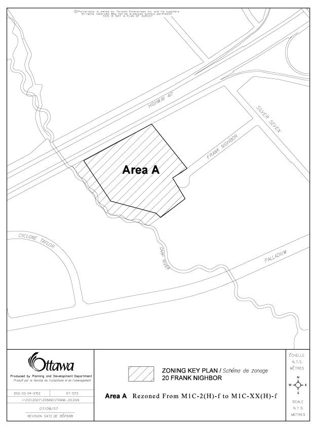
LOCATION MAP DOCUMENT
1
CONCEPTUAL SITE PLAN DOCUMENT
2
FLOOD
FRINGE/FLOODWAY MAP DOCUMENT 3
DETAILS OF RECOMMENDED ZONING DOCUMENT
4
1. Schedule “A” of By-law Number 138-93 of the former City of Kanata is amended by rezoning the lands shown as Area “A” on Document 5 from “M1C-2(H)-f” (Light Industrial, Mixed, Exception 2, Holding (Flood Fringe)) to “M1C-XX(H)-f” (Light Industrial, Mixed, Exception, Holding (Flood Fringe)).
2. Section 6.1 (Industrial Zone Provisions, Permitted Uses) of By-law Number 138-93 of the former City of Kanata shall be amended to add the following:
a) M1C-XX Zone
(i) On land zoned M1C-XX, all of the provisions of the “M1C” zone shall apply except for those contrary to the following:
1.
Permitted Uses:
-All permitted uses in the M1C Zone;
-Automobile Related Retail Uses;
-Automobile Rental Establishments;
-Automobile Sales Dealership;
-Department Store;
-Planned Retail Centre;
-Retail Store;
-Retail Warehouse;
-Shopping Centre.
2. All permitted uses in the M1C-XX Zone must employ concealed or enclosed storage.
3. Automobile Related Retail Uses cannot exceed 25% of the total land area within the M1C-XX Zone, and cannot be located abutting Highway 417.
4. "Retail Store" means a building or structure or part thereof where consumer goods are displayed for sale or rent, or sold directly to the public for the purchaser's own use, and includes a garden centre and a home sales display court.
5. “Shopping Centre” means one or more buildings designed, developed and managed as a unit primarily for commercial uses and having the required off-street parking provided on the same lot.
6. Notwithstanding [ITS1]Subsections 6.2 and 6.4, the following provisions shall apply to a Department Store, a Planned Retail Centre, a Retail Store, a Retail Warehouse, and a Shopping Centre:
a. Minimum Lot Area: 0.81 [ITS2]hectares
b. Maximum Allowable Coverage: 45[ITS3]% of the total lot area
c. Minimum Lot Frontage: 45.0 metres[ITS4]
d. Minimum Front Yard: 3.0 metres
e. Minimum Exterior Side Yard: 3.0 metres
f. Minimum Interior Side Yard: 3.0 metres
g. Minimum Rear Yard: 3.0 metres
h. Maximum Building Height: 11.0 metres[ITS5]
i. A strip of landscaped open space with a minimum width of 6.0 metres shall be provided between any parking spaces or paved area and the lot lines adjacent to Highway 417 and Frank Nighbor Place.
j. The parking rate for a Department Store, a Planned Retail Centre, a Retail Store, a Retail Warehouse and a Shopping Centre shall be a minimum of 1 parking space per 20 square metres of gross floor area.
7. For the lands zoned “M1C-XX” that are subject to holding provisions denoted by the holding (H) symbol identified on Schedule “A”, the holding symbol may only be lifted when the following conditions have been fulfilled to the satisfaction of the Director, Planning Branch:
a. The detailed design for the roadway modifications described in Exhibit 61 to the Ontario Municipal Board hearing regarding 15 Frank Nighbor Place and 737 and 777 Silver Seven Road (File Nos. PL051066, PL060317 and PL060318) has been approved by the City;
b. All necessary road widenings to accommodate the roadway modifications identified in subclause 5(a) above have been conveyed to the City;
c. A registered cost sharing agreement to construct the roadway modifications identified in subclause 5(a) above has been entered into between the owners of 15 Frank Nighbor Place, 20 Frank Nighbor Place, 720 Silver Seven Road, 737 Silver Seven Road and 777 Silver Seven Road and provided to the City;
d. An implementation plan including a construction schedule for the roadway modifications identified in subclause 5(a) above has been provided to the City;
e. A performance deposit has been provided to the City for the roadway modifications identified in subclause 5(a) above; and
f. Prior to the lifting of the holding (H) symbol, a Department Store, a Planned Retail Centre, a Retail Store, a Retail Warehouse and a Shopping Centre are excluded from the list of permitted uses in “M1C-XX” zone.
ZONING KEY PLAN DOCUMENT 5