|
1. TENTH LINE ROAD AND
BLACKBURN HAMLET BY-PASS EXTENSION INTERSECTION DESIGN CONCEPTION DE L’INTERSECTION DU CHEMIN TENTH LINE
ET DU PROLONGEMENT DE LA ROCADE DE BLACKBURN HAMLET |
Committee recommendation
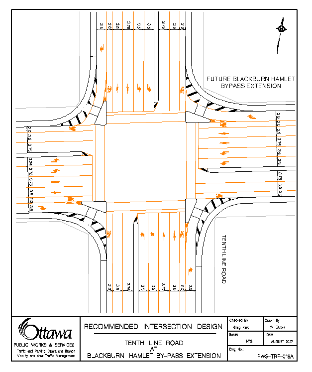
That Council approve the Tenth Line Road and Blackburn Hamlet By-pass Extension intersection design as presented in Document 2 (Drawing PWS-TRF-018A).
Recommandation dU ComitÉ
Que le
Conseil approuve la conception de l’intersection du chemin Tenth Line et du
prolongement de la rocade de Blackburn Hamlet présentée dans le document 2
(dessin PWS-TRF-018A).
Documentation
1.
Deputy City Manager, Public Works and Service report dated 7 September 2007
(ACS2007-PWS-TRF-0018).
2.
Extract of the
Draft Minutes 11, Transportation Committee, 19 September 2007
Report to/Rapport au :
Comité des transports
and Council / et au Conseil
7 September 2007 / 7 septembre 2007
Submitted
by/Soumis par:
R.G. Hewitt, Deputy City
Manager/Directeur municipal adjoint
Public Works and Services/Services
et Travaux publics
Contact Person/Personne-ressource
: Michael J. Flainek, M.Eng., P.Eng., Director/directeur
Traffic and Parking Operations/Circulation et
stationnement
613-580-2424 x 26882, Michael.Flainek@ottawa.ca
|
SUBJECT: |
TENTH LINE ROAD AND BLACKBURN HAMLET BY-PASS EXTENSION
INTERSECTION DESIGN |
|
|
|
|
OBJET : |
CONCEPTION
DE L’INTERSECTION DU CHEMIN TENTH LINE ET DU
PROLONGEMENT DE LA ROCADE DE BLACKBURN HAMLET |
REPORT RECOMMENDATION
That Transportation Committee recommend Council approve the Tenth Line Road and Blackburn Hamlet By-pass Extension intersection design as presented in Document 2 (Drawing PWS-TRF-018A).
RECOMMANDATION DU
RAPPORT
Que le
Comité des transports recommande au Conseil d’approuver la conception de
l’intersection du chemin Tenth Line et du prolongement de la rocade de
Blackburn Hamlet présentée dans le document 2 (dessin PWS-TRF-018A).
BACKGROUND
It is anticipated that Ottawa’s East Urban Community will continue to grow reaching 131,000 people and 45,000 jobs by 2021. In recent years, significant residential and commercial development has occurred along the Innes Road corridor. New infrastructure and roadways will be required to accommodate this growth. Tenth Line Road has been identified as part of the overall road system improvements needed to support this growth. It should be noted that full development of lands on both sides of Tenth Line Road is anticipated within the Official Plan (OP) horizon of 2021.
In order to meet planned construction deadlines for a major sanitary sewer and a roadway section between Innes Road and Lakepointe Drive, the Tenth Line Road Environmental Assessment was conducted throughout 2006 and presented to Transportation Committee in August 2006. The Tenth Line Road EA concluded that widening to a 4-lane urban divided arterial, including exclusive bicycle lanes and pedestrian facilities is the appropriate development plan for the roadway. This plan will be implemented throughout the length of Tenth Line Road, from Innes Road to the Urban Boundary, as development continues further south (refer to Document 1)
On 16 August 2006, Transportation Committee approved the recommendations of the Tenth Line Road EA and directed staff to return with a detailed design for future major intersections along Tenth Line Road (report # ACS2006-PGM-APR-0160). It should be noted that following Committee and Council Approval of the EA two proponents wrote to the Minister of Environment requesting a Part II Order (Bump Up). In June of this year, the Minister rejected the Part II Order requests and supported staff's recommendations. Therefore, the EA is approved and all works related to the project once approved can proceed. This report responds to the direction received from Transportation Committee and presents a recommended detailed design (Document 2) for the intersection of Tenth Line Road at the future Blackburn Hamlet By-Pass Extension.
Three design options were compared to determine the recommendations of this report:
- A simple open throat non-channelized design;
- A functional EA design (presented at Transportation Committee, 16 August 2006); and
- A revised EA design prepared by PWS staff.
The timing of this report is based on the need to confirm land requirements on adjacent land development proposals.
DISCUSSION
During the EA review process, consideration was given to a broad array of design concepts for the intersection of d Tenth Line Road at the future Blackburn Hamlet By-Pass Extension. Design objectives sought to limit road right-of-way widening requirements, while accommodating forecasted pedestrian, cyclist, transit and motor vehicle mobility and travel demands. The preferred design is recommended after comparisons against the previous functional design (presented at Transportation Committee, 16 August 2006) and a simple open throat non-channelized design.
To meet future travel and mobility demands this report provides a balanced approach to:
· Meet the needs of the various intersection users through to 2021;
· Reduce the impacts of road widening requirements on adjacent lands;
· Comply with the City’s Official Plan (OP) and Transportation Master Plan (TMP) objectives;
· Conform to current engineering design standards; and
· Satisfies the underlying OP principles of providing a safe and efficient transportation network.
Traffic planning within the Tenth Line Road EA is based on the OP assumption that there will continue to be a shift away from private automobile use towards public transit. Traffic projections have been reduced to reflect this assumption. Failure to achieve the OP modal shares will result in significant reductions in LOS at this intersection.
It is expected that traffic levels will continue to grow at this intersection beyond 2021. The Mer Bleue bog limits the arterial road system and is expected to continue to impact traffic levels and turn movements at the Tenth Line Road / Blackburn By-Pass Extension intersection. Extension. Staff took into consideration, when making intersection operations and design recommendation, the possible significant additional pressures post-2021. These pressures are however beyond the scope of the EA for Tenth Line Road.
A key consideration in roadway planning is the amount of land required for the construction and maintenance of road corridor features and the provision of clear sightlines for the safe operation of the intersection. Within the Tenth Line Road EA, considerable effort was made to limit right-of-way width to the OP specification of 37.5 meters. This was achieved along the corridor with the exception of the intersection of Tenth Line Road and Blackburn Hamlet By-pass Extension where the required right-of-way was widened to 41.5 meters and corner triangles were required to accommodate the physical needs of the right turn lane corner radii (channelized or not), required sight lines, maintenance and utility needs.
The process of determining corner triangle requirements can be broken down into two components, property ownership requirements and sightline requirements. Property ownerships requirements are determined through the consideration of geometric design elements of a road (lanes, curbs, sidewalks), along with the maintenance and utility requirements. Sightline requirements consider the need for vertical use restrictions near the intersection to provide a safe viewing distance of cross street traffic. Both components were addressed as part of the EA process.
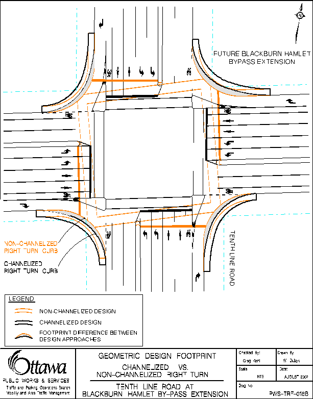
The footprint of both the simple open throat design and the recommended design were found to be virtually the same size. The only difference appears in the right-turn corners where the recommended design extends outward by a meter on average (refer to Document 3). Table 1 identifies required corner property and the percent reduction in land from the original EA functional design.
Table 1: Corner
Triangle Land Requirements
|
Design |
Corner |
Recommended Design (Right Turn Channels) |
Simple
Open Throat Design (No
Right-Turn Channels) |
|
Land Requirement (% reduction from original EA design) |
NE |
31.9 m2 (66%) |
13.9 m2 (85%) |
|
SE |
0.5 m2 (97%) |
0.0 m2 (100%) |
|
|
SW |
23.4 m2 (74%) |
12.2
m2 (86%) |
|
|
NW |
1.0 m2 (99%) |
0.0 m2 (100%) |
Both designs require a comparable amount of additional land from adjacent landowners. However, both designs require significantly less land than the Tenth Line EA functional design presented at the 16 August 2006 Transportation Committee meeting.
Sightline requirements are the same for both designs and have the same impact on how adjacent properties can be developed. Physical vertical features impacting driver sightlines within the sight triangles will typically be restricted through the Site Plan Control process. This ensures unobstructed views and allows the intersection to operate in a safe manner. Sightline triangle requirements were found to be in the area of 20m x 20m for all corners.
When comparing the two right-turn approaches, and reflecting on the OP and TMP objectives of safety and efficiency, the following is found:
- Overall the two designs can be said to be comparable or equal in terms of safety.
- In terms of efficiency, the recommended design provides greater benefits by: separating out right-turn traffic flow; shortening pedestrian crossing distances; reducing minimum crossing times; and improving traffic control time management. This will reduced pedestrian wait times, allow greater flexibility to optimize signal timing to address peak flows, reduce congestion delay; decrease CO2 emissions from idling, and increase future flexibility to address TDM initiatives such as transit priority accommodation. (Specifics associated with the detailed design are presented in Document 4 – Detail Design Elements Review)
- From a cost and maintenance perspective both designs have their advantages and disadvantages but overall are essentially equal.
Recommended Intersection Design
Based on a detailed review of the alternative design approaches for safety, efficiency and future demands, the channelized design is recommended for the intersection of Tenth Line Road at the Blackburn Hamlet By-Pass Extension (as presented in Document 2).
CITY STRATEGIC DIRECTIONS
The intersection design as recommended in this report has been developed and presented with the following City Strategic Direction priority and objective in mind:
Priority: A1 Transportation
Objective: Improve the City’s road network to afford ease of mobility, keep pace with growth, reduce congestion and work towards modal split targets.
CONSULTATION
The ward Councillor was consulted and concurs with the recommendation.
Consultation was conducted during the Environmental Assessment Process. No further consultation was undertaken in the preparation of this report. However, the recommendations of this report were discussed with the neighbouring property owners who made representation before Transportation Committee in August 2006.
This report was also advertised through the City's standard public notification process.
FINANCIAL
IMPLICATIONS
The report recommends approval of the design
described in Document 2 for the Tenth Line Road intersection at the Blackburn
Hamlet Bypass Extension. This approval
will enable final design, land cost and construction estimates to be
determined.
The budgetary requirements, once determined,
for Tenth Line Road from Lakepointe Drive to the Urban Boundary including the
intersection at the Blackburn Hamlet Bypass Extension will be requested by
Planning, Transit and Environment in their 2008 to 2010 Capital Budget
submission.
SUPPORTING
DOCUMENTATION
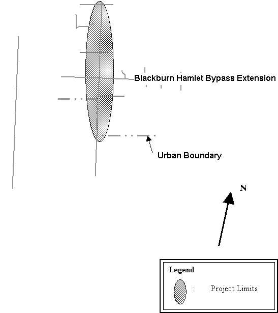
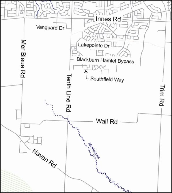
Document 1 – Tenth Line Road EA Project Limits
Document 2 – Recommended Intersection Design, Tenth Line Road at Blackburn Hamlet By-Pass Extension
Document 3
– Comparison of Channelized vs Non-Channelized Design
Document 4
– Detailed Design Elements Review
DISPOSITION
TENTH LINE ROAD EA PROJECT LIMITS
![]()
![]()
Safe Accommodation
of Anticipated Traffic Demand to 2021
In accordance with the Tenth Line Road Widening EA, projections for 2021 traffic in the East Urban Community have been developed based on a number of key assumptions which act to reduce forecast travel demand and reduce roadway size. These assumptions are listed as follows:
· It is assumed that the intersection will support pedestrian travel demand associated with a 2.0 meter concrete sidewalk (East side) and a 3.0 meter multi-user asphalt pathway (West side) on Tenth Line Road, and similar facilities on Blackburn Hamlet By-Pass Extension;
· It is assumed that OP provisions for transit mode split will be achieved;
· It is assumed that travel demand management and other trip reduction provisions have been fully achieved by 2021;
· It is assumed that a major rapid transit facility will be constructed adjacent to the Blackburn Hamlet By-Pass Extension Corridor;
· It is assumed that the Blackburn Hamlet By-Pass Extension will be constructed as a major East-West arterial with greater carrying capacity than Innes Road; and
· It is assumed that distances between major East-West arterial roads will be consistent with Official Plan provisions.
Based on the foregoing assumptions, the following minimum requirements for road design elements were recommended for the intersection of Tenth Line Road and future Blackburn Hamlet By-Pass Extension, during the EA process:
Tenth Line Road will require:
. 1 sidewalk or multi-user pathway per roadside
. 1 on-road bicycle lane northbound and southbound
. 2 straight-through lanes northbound and southbound
. 2 left-turn lanes northbound and southbound
. 1 free flow right turn lane with geometrics to accommodate heavy vehicles without impacting adjacent lanes, northbound and southbound.
Blackburn Hamlet By-Pass Extension will
require:
. 1 sidewalk or multi-user pathway per roadside
. 1 on-road bicycle lane eastbound and westbound
. 2 straight-through lanes eastbound and
westbound
. 2 left-turn lanes eastbound and westbound
. 1 free flow right turn lane with geometrics to accommodate heavy vehicles without impacting adjacent lanes, eastbound and westbound.
Traffic Signal
Timing, Right-turn Channelization and Pedestrian Islands
Traffic signal timing at major intersections is guided by a number of key considerations. The length of time required for a full cycle of all phases of traffic signals for arterial to arterial roadways ranges from 60 to 140 seconds (meaning that a driver approaching an intersection can expect to wait between 30 and 70 seconds on average before receiving a green signal). The preferred cycle time for a particular intersection is guided by:
· Provision of a safe pedestrian crossing time (shortest crossing distance between pedestrian refuges, relates to islands or sidewalks depending on the design)
· Traffic demands on both roadways (volume and movement, all modes),
· Driving and walking characteristics of area users,
· Functional layout of the intersection (required lane designation),
· Synchronization requirements of up-stream and down-stream signals, and
· Other possible factors (time for transit-priority signalization, specialized design elements, etc)
Consistent with these objectives, traffic signals must first be designed to ensure that pedestrians (as the slowest moving intersection user) can safely and comfortably cross the intersection. Only following the provision of safe times for pedestrians, are intersections designed to offer additional time for other roadway users to pass through an intersection. Therefore, it is only after pedestrian crossing times are calculated can the remaining available cycle time be allocated amongst the other intersection users. Doing so in the most efficient manner allows for signal timing optimization and flexibility to effectively address all users at all times of the day.
For the Tenth Line Road / Blackburn Hamlet By-Pass Extension intersection walking distances and minimum pedestrian clearance times were calculated and presented in Table 2 for two design approaches; a channelized right-turn design (recommended design) and a simple open throat intersection design, both of which support the required design elements (lanes and sidewalks). The designs have been presented in Document 3 where the design concepts have been overlaid on each other for footprint comparison and crosswalk identification. Pedestrian times were developed using standard walking speeds (1.2 m/sec) and a 7 second minimum ‘walk’ display for each direction of pedestrian travel.
Table 2:
Intersection Pedestrian
Crossing Distances and Times
|
Design |
Minimum Pedestrian
Crossing Distance and Time |
|
Recommended Design (Right Turn Channels) |
27m (29.5 sec) |
|
Simple Open Throat Design (No Right-Turn Channels) |
37m (37.8 sec) |
The additional 10m in the simple open throat design results from the crossing of an additional lane that falls under the control of the traffic control signal and the distance associated with the corner radii. Corner radii are larger for simple arterial-to-arterial intersections to ensure that heavy vehicles are accommodated by the road’s driving surface and do not encroach onto the adjacent sidewalk.
The shorter crossing distance in the recommended solution is
a product of right-turn channelization and pedestrian islands use. Within a simple open throat design no formal
channelization exists although there are surface areas within the intersection
that are unused. These areas fall in the corners of an intersection between the
vehicle paths making right-turns, proceeding straight through and those
straight across the intersection. To maximize the efficiency of the
intersection islands are placed at these locations.. Functionally they support pedestrian movement and traffic signal
hardware with little to no expansion to the intersection’s overall footprint
(refer to Document 3). The resulting
product is a shorter pedestrian walking distance that is under the control of
the traffic signals.
Intersection
Operation
To assess intersection performance from a comparison perspective, a detailed evaluation of intersection function, delay and queuing was conducted for both the preferred design and the simple open throat design configuration. In summary, due to the additional time given to pedestrians crossing the 37 meter sidewalk to sidewalk distance, the simple open throat design intersection operates at a reduced overall Level of Service (LOS) during the peak travel periods of the average weekday. Due to heavy vehicular demand, however, both designs would operate with left turn movements at LOS F (with delays of greater than one signal length on average, and below TMP desired standards).
Overall the recommended design results in fewer movements operating at LOS F. In a suburban environment, the larger pedestrian travel distance associated with the simple open throat design becomes a constraining factor, resulting in poorer intersection performance and additional queuing and delay. By contrast, the recommended design requires less signal time reserved for pedestrian travel (29.5 seconds) due to the shorter pedestrian walking distance between islands. The result is that the intersection operates at an improved LOS with reduced congestion, queuing and delay, leaving additional signal cycle time for daily and seasonal adjustments to accommodate the given traffic demand.