|
2. EAGLESON ROAD (CADENCE GATE / COPE ROAD TO FLEWELLYN
ROAD) / FERNBANK ROAD (TERRY FOX DRIVE TO EAGLESON ROAD) ENVIRONMENTAL
ASSESSMENT ÉVALUATION ENVIRONNEMENTALE DU CHEMIN EAGLESON (CADENCE GATE / CHEMIN
COPE JUSQU’AU CHEMIN FLEWELLYN) / CHEMIN FERNBANK (PROMENADE TERRY FOX AU
CHEMIN EAGLESON) |
Committee recommendationS as amended
That Council:
1. Approve the findings and recommended
plan of the Eagleson Road / Fernbank Road Environmental Assessment Study, as
shown in Documents 1 and 2.
2. Direct staff to prepare the
Environmental Study Report for the Eagleson Road/ Fernbank Road Environmental
Assessment and post it for the 30-day public review period, in accordance with
the Ontario Environmental Assessment Act.
3. Direct staff to expand the Eagleson
Road (Cadence Gate to Hope Side Road) project (901121) in the Capital Budget
Forecast 2008-2016 to include works to Flewellyn Road.
4. Direct staff to introduce a new project
for Fernbank Road (Terry Fox to Eagleson) in the Development Charge Background
Study and the Long Range Financial Plan.
5. Direct staff to consider at the time
of construction traffic circles at
·
Emerald Meadows Drive / Romina Street and
Eagleson Road; and
·
Terry Fox Drive / Hope Side Road and Eagleson
Road.
RecommandationS
modifiÉes dU ComitÉ
Que le Conseil :
1. approuve les constatations et le plan d’Étude d’évaluation environnementale recommandé portant sur le chemin Eagleson et le chemin Fernbank, tels que décrits dans les Documents 1 et 2;
2. demande
au personnel de préparer un rapport d’étude environnementale portant sur
l’évaluation environnementale du chemin Eagleson et du chemin Fernbank, et de
l’afficher pendant une période d’examen public de 30 jours, conformément à la Loi
sur les évaluations environnementales de l’Ontario;
3. demande
au personnel d’étendre le projet du chemin Eagleson (Cadence Gate au chemin de
traverse Hope) (901121), dans les prévisions de budget d’immobilisations 2008
2016, de façon à y inclure les travaux prévus pour le chemin Flewellyn;
4. demande
au personnel d’introduire un nouveau projet pour le chemin Fernbank (Terry Fox
à Eagleson) dans l’Étude préliminaire des redevances d’aménagement et dans le
Plan financier à long terme.
5. demande
au personnel d’envisager au moment de la construction des carrefours giratoires
à la hauteur :
·
de la
promenade Emerald Meadows / rue Romina et du chemin Eagleson;
·
de la
promenade Terry Fox / du chemin Hope Side et du chemin Eagleson.
for the information of council
The Committee also approved the following directives to Staff:
1. That the final study report will clearly indicate that the
area for noise mitigation identified in the staff report means a noise barrier
wall for current residents backing on Eagleson Road.
2. That
the final study report will include comments by a community resident about the
need for a traffic signal at the Trans Canada Trail along with staff comments.
Pour la gouverne du
Conseil
Le Comité a approuvé les directives suivantes :
1.
que le
rapport d’étude final indique clairement que le secteur nécessitant des mesures
d’atténuation du bruit, désigné dans le rapport du personnel, signifie qu’un
ouvrage antibruit sera construit pour les résidents dont la cour donne sur le
chemin Eagleson.
2.
que le
rapport d’étude final comprennent les commentaires d’un résident de la
communauté concernant la nécessité d’un feu de circulation à la hauteur du
Sentier transcanadien ainsi que les commentaires du personnel.
Documentation
1.
Deputy City Manager, Planning, Transit and the
Environment report dated
10 September 2007 (ACS2007-PTE-POL-0058).
2.
Extract of the
Draft Minutes 11, Transportation Committee, 19 September 2007
Report to/Rapport au :
Comité des transports
and Council / et au Conseil
10 September 2007 / le 10 septembre 2007
Submitted by/Soumis par : Nancy Schepers, Deputy City Manager/Directeur
municipal adjoint,
Planning, Transit and the
Environment/Urbanisme, Transport en commun et Evironnement
Contact Person/Personne ressource : Vivi Chi, Manager/Gestionnaire,
Transportation and Infrastructure Planning/Planification, Transport et
infrastructure
Planning Branch/Direction de l’urbanisme
(613) 580-2424 x21877, vivi.chi@ottawa.ca
REPORT RECOMMENDATION
That
Transportation Committee recommend Council:
1.
Approve
the findings and recommended plan of the Eagleson Road / Fernbank Road
Environmental Assessment Study, as shown in Documents 1 and 2.
2.
Direct
staff to prepare the Environmental Study Report for the Eagleson Road/ Fernbank
Road Environmental Assessment and post it for the 30-day public review period,
in accordance with the Ontario
Environmental Assessment Act.
3.
Direct
staff to expand the Eagleson Road (Cadence Gate to Hope Side Road) project
(901121) in the Capital Budget Forecast 2008-2016 to include works to Flewellyn
Road.
4.
Direct staff to
introduce a new project for Fernbank Road (Terry Fox to Eagleson) in the
Development Charge Background Study and the Long Range Financial Plan.
RECOMMANDATION DU RAPPORT
Que le Comité des transports recommande au Conseil :
1.
D’approuver les constatations et le
plan d’Étude d’évaluation environnementale recommandé portant sur le chemin
Eagleson et le chemin Fernbank, tel que décrits dans les Documents 1 et 2;
2.
De demander au personnel de préparer
un rapport d’étude environnementale portant sur l’évaluation environnementale
du chemin Eagleson et du chemin Fernbank, et de l’afficher pendant une période
d’examen public de 30 jours, conformément à la Loi sur les évaluations
environnementales de l’Ontario;
3.
De demander au personnel d’étendre
le projet du chemin Eagleson (Cadence Gate au chemin de traverse Hope)
(901121), dans les prévisions de budget d’immobilisations 2008 2016, de façon à
y inclure les travaux prévus pour le chemin Flewellyn;
4.
De demander au personnel
d’introduire un nouveau projet pour le chemin Fernbank (Terry Fox à Eagleson)
dans l’Étude préliminaire des redevances d’aménagement et dans le Plan
financier à long terme.
EXECUTIVE SUMMARY
Assumptions and Analysis:
The widening
of Eagleson Road between Cadence Gate/Cope Road and Terry Fox Drive/Hope Side
Road is identified in the current Transportation
Master Plan (TMP) as a Phase 1 project (i.e. by 2008) to address
increasing transportation demand within the West Urban Community (WUC). The WUC is comprised of Kanata, Kanata West
and Stittsville.
On 18 May 2005, Transportation Committee
approved the Statement of Work (SoW) setting out the methodology, public
consultation and deliverables for an Environmental Assessment (EA) study for
this project. During the course of the study, Fernbank Road between Terry Fox
Drive and Eagleson Road was added to the study to address the future needs of
planned development. Accordingly, the scope of this project was expanded to
obtain the necessary approvals for the reconstruction of Fernbank Road.
Based on the transportation, land use and
growth issues the following summarizes the problems and opportunities being
addressed by this study:
Eagleson Road:
- Background volumes have grown and will
continue to grow;
- Significant development is planned that
will rely on the Eagleson Road corridor;
- Widening Eagleson Road can meet
increased traffic demands;
- Need to provide pedestrian and cycling
facilities along Eagleson Road; and
- Opportunity to implement Arterial
Mainstreet design elements on the west side of Eagleson Road.
Fernbank Road:
- Development on both sides of Fernbank
Road necessitates a review of the roadway design.
The EA recommended plan identifies the
widening of Eagleson Road and the reconstruction of Fernbank Road as required
to support the existing and future developments planned for the area.
Approximately 2.0 km of Eagleson Road will be widened from a two-lane undivided
rural arterial to a four-lane divided arterial roadway. Approximately 0.6 km of Fernbank Road will
be upgraded from a rural to urban roadway.
Both roadways include the addition of cycling
and pedestrian facilities (i.e. on-street bicycle lanes and sidewalks) as a key
feature of the conversion from rural cross-sections to urban
cross-sections. The study also
addressed road crossings by the Monahan Drain multi-use pathway on both
Eagleson and Fernbank Road.
Two alternatives were developed for
consideration: at-grade crossings and below-grade crossings (i.e. underpasses).
The below-grade crossings were not found to be feasible due to cost,
waterlevels in the adjacent drainage facilities, and impact on adjacent
property.
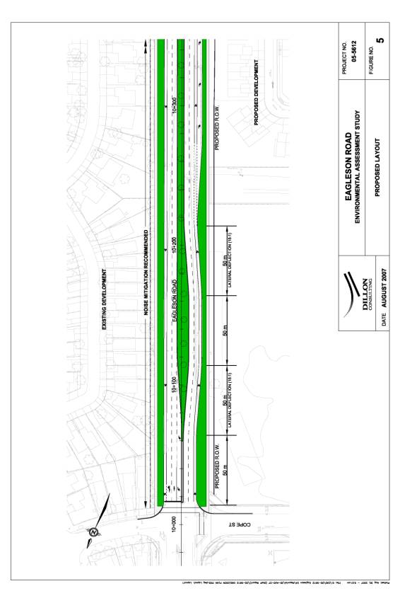
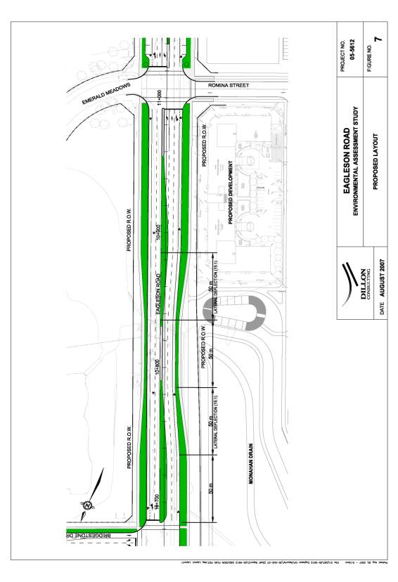
The recommended approach is to direct multi-use pathway users on Eagleson Road to a signalized intersection at Bridgestone for safe crossing. An at-grade crossing of Fernbank Road can be provided at the intersection of Fernbank and Eagleson Roads, or be facilitated through the use of a pedestrian traffic signal (if pedestrian signal warrants are met) that could be located where the pathway first meets Fernbank Road, approximately 150 m west of the intersection of Fernbank Road and Eagleson Road.
Financial Implications:
The estimated cost to widen Eagleson Road to a four lane urban arterial divided cross-section from Cadence Gate/Cope Road to Terry Fox Drive/Hope Side Road, with transition features extending to Flewellyn Road, incorporating bicycle lanes and on-street parking is approximately $11 M. The estimated cost to reconstruct Fernbank Road to a two-lane urban arterial cross-section from Terry Fox Drive to Eagleson Road is approximately $3.5 M.
Public Consultation/Input:
The EA
study was undertaken as a “Schedule C” Municipal EA under the Municipal Class Environmental Assessment (2000) guidelines.
Public consultation for the project included the following:
- “Notice of Project Commencement”
advertised in local newspapers (1 March 2006)
- Public Open House #1 – 4 April 2006
- Public Open House #2 – 22 June 2006
- Public Open House #3 – 27 June 2007
- Agency Consultation Group (ACG) -
throughout the course of the study
- Public Consultation Group (PCG) input
sought throughout the course of the study
- General Inquiries - Contact with various
public stakeholders to respond to comments or questions throughout the
study
Approximately 50 people attended the three Public Open Houses. Comment sheets were provided at each of these events and feedback was received during these events as well as throughout the course of the study. Comments were generally supportive of the project with the following issues raised by the public: a need to implement measures to provide noise mitigation; the importance of providing appropriate pedestrian and bicycle facilities, and; the merits of providing or not providing on-street parking.
RÉSUMÉ
Hypothèses et analyse :
Dans le Plan directeur des
transports, l’élargissement du chemin Eagleson entre Cadence Gate/chemin Cope
et la promenade Terry Fox/chemin de traverse Hope, est identifié comme étant un
projet de la phase 1 (c.‑à‑d. devant être effectué d’ici 2008)
destiné à répondre aux demandes de nouveaux moyens de transport dans la
collectivité urbaine de l’ouest (CUO). La CUO est la zone comprise entre
Kanata, Kanata ouest et Stittsville.
Le 18 mai 2005, le Comité
des transports approuvait un énoncé de travail (ET) qui décrivait la
méthodologie, les consultations publiques et les produits livrables nécessaires
à l’étude de l’évaluation environnementale (EE) propre à ce projet. Pendant le
déroulement de l’étude, le chemin Fernbank, situé entre la promenade Terry Fox
et le chemin Eagleson, a été ajouté à l’étude afin de répondre aux futurs
besoins de travaux d’aménagement. Par conséquent, l’étendue de ce projet a été
élargie afin d’obtenir les approbations nécessaires à la reconstruction du
chemin Fernbank.
Basés sur les problèmes de
transport, d’utilisation des terrains et de croissance, les points suivants
résument les enjeux et les possibilités abordés dans cette étude :
Chemin Eagleson :
·
La
circulation d’arrière-plan s’est accrue et continuera à croître;
·
des
travaux d’aménagement importants sont prévus, et ceux‑ci dépendront du
couloir du chemin Eagleson;
·
l’élargissement
du chemin Eagleson permettra d’absorber l’accroissement de circulation;
·
il sera
nécessaire d’offrir des installations pour piétons et cyclistes le long du
chemin Eagleson; et
·
possibilité
de mettre en œuvre des éléments de conception de l’artère principale du côté
ouest du chemin Eagleson.
Chemin Fernbank :
·
L’aménagement
des deux côtés du chemin Fernbank nécessitera une révision du tracé du chemin.
Le plan d’évaluation
environnementale recommandé identifie l’élargissement du chemin Eagleson et la
reconstruction du chemin Fernbank comme étant des éléments nécessaires aux
aménagements actuels et futurs prévus pour cette zone. Environ
2 kilomètres du chemin Eagleson seront élargis, et passeront d’artère
rurale à deux voies non divisée à route à quatre voies divisée. Environ
600 mètres du chemin Fernbank passeront de chemin rural à route urbaine.
Les deux routes incluront des
installations pour piétons et cyclistes (c.‑à‑d. des pistes
cyclables sur la voierie et des trottoirs) et cet ajout constituera l’élément
clé de la conversion d’intersection rurale à intersection urbaine. L’étude
porte également sur le croisement des chemins Eagleson et Fernbank par le
sentier polyvalent du drain Monahan.
Les deux solutions de rechange
suivantes ont été élaborées pour étude : des passages à niveau et des
intersections souterraines (tunnels). Il a par la suite été décidé que les
intersections souterraines ne seraient pas réalisables compte tenu de leur
prix, des niveaux d’eau dans les aménagements de drainage adjacents, et de
l’impact possible sur les propriétés adjacentes.
La solution recommandée est de diriger
les utilisateurs du sentier polyvalent du chemin Eagleson vers une intersection
équipée de feux de signalisation à Bridgestone pour qu’ils puissent traverser
en toute sécurité. Un passage pour traverser le chemin Fernbank pourrait être
installé à la croisée des chemins Fernbank et Eagleson, ou bien on pourrait
faciliter la traversée de ces chemins grâce à l’installation de feux de
signalisation pour piétons (si les conditions s’y prêtent) qui pourraient être
situés à l’endroit où le sentier croise pour la première fois le chemin
Fernbank, c’est‑à-dire à environ 150 mètres à l’ouest de
l’intersection des chemins Fernbank et Eagleson.
Répercussions
financières :
L’élargissement du chemin Eagleson,
destiné à le convertir en une route urbaine à quatre voies, divisée par une
intersection de Cadence Gate/chemin Cope à la promenade Terry Fox/chemin de
traverse Hope, agrémentée d’éléments de transition allant jusqu’au chemin
Flewellyn, et englobant des pistes cyclables et des emplacements de
stationnement sur rue, est évalué à un coût approximatif de 11 millions de
dollars. Le coût prévu pour reconstruire le chemin Fernbank en une artère
urbaine à deux voies, entre la promenade Terry Fox et le chemin Eagleson, se
chiffre approximativement à 3,5 millions de dollars.
Consultation
publique / commentaires :
L’étude d’évaluation
environnementale a été entreprise sous l’« annexe C » de
l’évaluation environnementale municipale, conformément aux Lignes
directrices d’évaluation environnementale de portée générale (2000). Les
consultations publiques effectuées dans le cadre de ce projet comprenaient
notamment :
·
Un
« avis de lancement du projet » affiché dans les journaux locaux (1er mars 2006)
·
La
réunion publique no 1 – le 4 avril 2006
·
La
réunion publique no 2 – le 22 juin 2006
·
La
réunion publique no 3 – le 27 juin 2007
·
Groupe
de consultation d’organismes (GCO) – pendant tout le déroulement de
l’étude
·
Groupes
de consultation publiques (GCP) – rétroactions reçues pendant tout le
déroulement de l’étude
·
Demandes
de renseignement général – contact avec les différents intervenants
publics afin de répondre aux commentaires et aux questions soulevées pendant le
déroulement de l’étude
Environ 50 personnes ont
assisté aux trois réunions publiques. À chaque rencontre, des feuilles de
commentaires ont été fournies et la rétroaction a été obtenue pendant les
réunions publiques tout comme pendant le reste du déroulement de l’étude. De
façon générale, les commentaires étaient positifs vis‑à-vis du projet, et
les points suivants ont été soulevés par le public : le besoin de mettre
en œuvre des mesures pour réduire le niveau de bruit; l’importance d’offrir des
aménagements pour piétons et cyclistes qui soient appropriés; et les avantages
et inconvénients d’offrir du stationnement sur rue.
BACKGROUND
The widening of Eagleson Road is required to
support existing and future development planned in south Kanata. The study area
was expanded in May 2006 to include the reconstruction of Fernbank Road from
Eagleson Road to Terry Fox Drive, to coordinate with adjacent development
plans.
For the purpose of this report, reference to
the Eagleson Road EA will include both the Eagleson Road and Fernbank Road
portions of the study. Each roadway will be discussed individually, although
they are included within a single study.
Planning Context for Study
The study area is part of the West Urban
Community (WUC) that includes Kanata, Kanata West and Stittsville. Population
projections for this area predict an increase of two and a half times the
current levels (from 73,000 to 186,000 persons), and a proportional increase in
employment levels.
In light of this projected growth, the
Transportation Master Plan (TMP) identifies the widening of Eagleson Road as a
response to the additional transportation demands which will be placed upon the
community infrastructure.
A number of development applications have
been submitted and are at various stages of approval for lands adjacent to the
study area. These include proposals for the development of residential
subdivisions as well as commercial and employment-type developments. Their
completion is directly linked to the upgrading of the two roadways.
Official Plan Conformity
The Official Plan (OP) designates the west
side of Eagleson Road as an Arterial Mainstreet. The designation extends from a point beyond the northern limits
of the study area, south to Terry Fox Drive/Hope Side Road. The Arterial
Mainstreet designation recognizes that Eagleson Road offers an opportunity to
create a denser and more compact urban form with mixed-use development and a
generally pedestrian-friendly environment.
In May 2006 the City released “Urban Design Guidelines for Development
along Arterial Mainstreets”. These
guidelines were considered within the design of Eagleson Road, which resulted
in the addition of features such as on-street parking.
Purpose of the Undertaking
The purpose of the undertaking is:
·
To respond to
growth pressures (existing and future) by providing adequate transportation capacity
in the study area; and
- To support the growth of Ottawa as a livable and economically viable city by planning infrastructure and services that are required to encourage sustainable land use practices, support desired modal shifts and prevent unacceptable congestion and delay.
DISCUSSION
As it exists
today, Eagleson Road (from Cadence Gate to Hope Side Road) is a two-lane,
undivided rural (roadside ditches provide drainage) arterial roadway. The
cross-sections for Eagleson Road and Fernbank Road do not provide pedestrian or
cycling facilities. The posted speed
limit is currently 60 km/h from north of the study area south to the Eagleson
Road/Emerald Meadows Road intersection; and 80 km/h south of this point.
Fernbank Road is a two-lane, rural arterial undivided roadway that currently
has a posted speed limit of 60 km/h.
With more development anticipated in the WUC
and surrounding villages (i.e. Richmond and Stittsville), the current
configuration of Eagleson Road will not meet projected future demand. The adjacent Fernbank Road area (between
Terry Fox Drive and Eagleson Road) is also being developed with urban
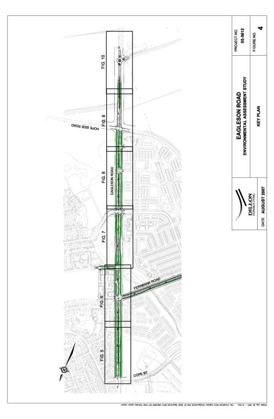
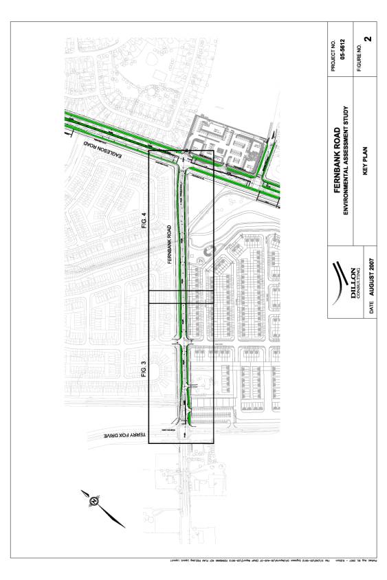
subdivisions that require the features of an urban roadway. Figure 1 illustrates the study area.
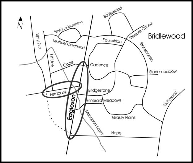
Figure 1: Eagleson Road EA Study Area
Problem/Opportunity
Statement
As described in the previous sections,
significant growth is projected in the area of south Kanata over the next 20
years. The Bridlewood and Emerald Meadows residential communities are
continuing to develop, as is the Kanata South Business Park and other planned
developments. These will all rely on Eagleson Road to serve the transportation
needs of the area.
The two-lane portion of Eagleson Road through
the study area has limited capacity to serve the projected travel demand and
the existing roadway cross-section is projected to result in capacity and
mobility issues. The design elements for Eagleson Road are consistent with the
projected transportation demand requirements while also incorporating the Urban Design Guidelines for Development
along Arterial Mainstreets (2006).
Widening of Eagleson Road will provide the
opportunity to include sidewalks and bicycle lanes on both sides of the road
between Cope Road and Terry Fox Drive/Hope Side Road. An opportunity to provide on-street parking is also available
between approximately Emerald Meadows and Terry Fox Drive/Hope Side Road,
consistent with the Arterial Mainstreet design guidelines.
Reconstruction of Fernbank Road will bring
the roadway up to an urban standard and provide sidewalks and bicycle lanes on
both sides of the road between Terry Fox Drive and Eagleson Road.
The Monahan Drain multi-use path crossing
through the study area is incorporated into the planning of both roadways.
Alternative Planning
Solutions
Five alternatives were assessed in terms of
their ability to address the existing and future transportation needs of the
study area:
- Do Nothing;
- Implement transportation demand
management (TDM) measures to reduce travel demand;
- Expand and enhance public transit
services (i.e., Park and Ride facilities) and enhance cycling routes in/to
the WUC;
- Expand other roadways (e.g., Terry Fox
Drive, and/or Richmond Road); and
- Expand Eagleson Road and reconstruct
Fernbank Road.
These
alternatives were evaluated on the basis of the ability to address the
problem/opportunity statement and the impacts on the social environment and the
natural environment.
- Do
Nothing – The Do Nothing alternative does not include any significant
improvements. Although the capital costs and environmental impacts of the Do Nothing alternative are low,
this alternative does not address the Eagleson Road transportation
capacity deficiency. The Do Nothing option
is not capable of meeting the problem/opportunity statement.
- Road
Widenings – The widening of other existing roads in
the vicinity (e.g., Terry Fox Drive, Eagleson Road north of the study area
and Richmond Road) were considered to address the projected capacity
deficiencies of Eagleson Road. The expansion of other roadways does not
address the immediate local roadway access needs for the planned
developments and does not further support the City’s planning goals for
the study area
- Alternative
Transportation Modes – Significant increases in pedestrian,
cycling and transit modal shares were assumed in the forecasting of road
demands. Deficient road capacity was still identified for Eagleson Road.
This alternative alone cannot solve the identified problem/opportunity
statement.
- Transportation
Systems Management (TSM) and Transportation Demand Management (TDM) – TSM
measures include various methods of maximizing the use of the existing
roads (e.g., traffic control devices, signage, turning lanes). TDM
measures reduce the demand for private auto use (e.g., ridesharing, carpooling,
telecommuting, etc.). TSM and TDM measures were assumed in forecasting
future roadway capacity. This solution cannot meet the problem/opportunity
statement on its own, but will form part of the package of solutions.
Preferred Solution
The preferred alternative solution, as
originally identified in the TMP includes a combination of: TDM / TSM measures,
alternative transportation modes (i.e. increased walking, cycling and transit),
the widening of Eagleson Road and reconstruction of Fernbank Road. This
solution addresses the following:
- Addresses transportation needs within
the study area; and
- Allows the City to identify the planned
cross-section and road Rights-of-Way in conjunction with the planning of
new adjacent communities.
Analysis and Evaluation Process
The Eagleson Road Study was separated into
two sections for analysis and evaluation of alternatives. This was done to
better address the specific requirements and issues of the differing roadways:
- Section 1: Eagleson Road: alternatives focused
on cross-sectional design and functional design characteristics (related
to horizontal alignment); and
- Section 2: Fernbank Road: no
cross-sectional alternatives were identified. Current and forecasted
volumes did not justify a widening of the roadway between Terry Fox Drive
and Eagleson Road.
Recommended Plan
Section 1 – Eagleson Road (Cadence Gate/Cope
Road to Terry Fox Drive/Hope Side Road)
For the widening of Eagleson Road, two
cross-section options were considered as follows:
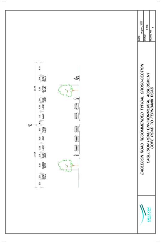
Typical
four-lane suburban arterial
This option would widen Eagleson Road to four
lanes of traffic and include dedicated bicycle lanes in each direction, and
sidewalks on both sides of the roadway. Both the cycling lanes and the
sidewalks would extend the entire length of the study area.
This design is contained within a standard
44.5 m Right-of-Way and features street lighting in the roadway median.
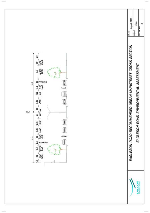
Four-lane
urban “Arterial Mainstreet”
This option would widen Eagleson Road to four
lanes of traffic and include dedicated bicycle lanes in each direction;
sidewalks on both sides of the road, and approximately 200 m of on-street
parking on the east side of the road immediately south of Emerald Meadows Drive
and approximately 300m of on-street parking on the west side. This design lies
within a standard 44.5 m Right-of-Way and features street lighting within the
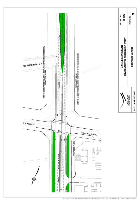
roadway median. The cross-section and plan view are illustrated in Document 1.
The “Arterial Mainstreet” option would
incorporate horizontal design features as speed reduction measures. These
include a gentle lateral shift in road alignment in the southbound lane
approximately 50 m south of Cope Road; south of (proposed) Bridgestone Drive at
the Monahan Drain crossing, and; south of Hope Side Road/Terry Fox Drive
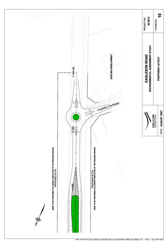
intersection. A roundabout is proposed
for the junction of Eagleson Road and Flewellyn Road to act as a transitional
feature for drivers approaching from the south as they enter the “Arterial
Mainstreet” area.
The urban “Arterial Mainstreet” option (four
lanes of traffic, provision of sidewalks and bicycle lanes and specific
sections of on-street parking) was selected as the preferred alternative for
Eagleson road in keeping with the Urban
Design Guidelines for Arterial Mainstreets.
The design incorporates a roundabout located at the junction of Eagleson Road and Flewellyn Road. This feature will act as a speed reduction measure, providing a visual and geometric cue that the driver is entering or exiting the urban area and will further reinforce the change in posted speed (80 km/h to 60 km/h in the north-bound direction).
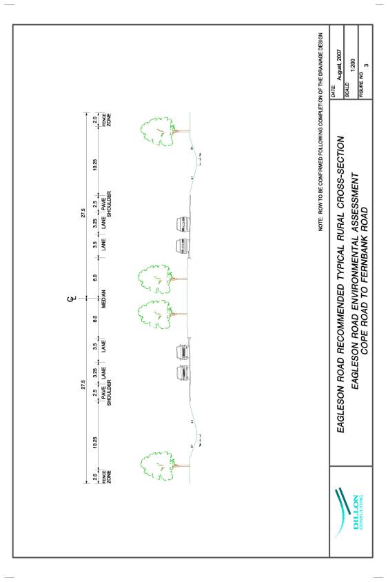
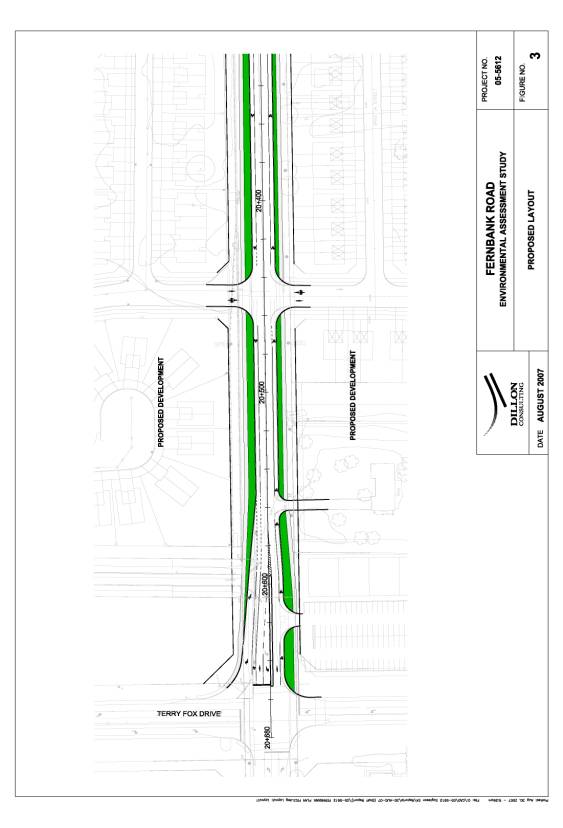
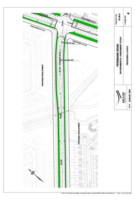
Section 2 – Fernbank Road (Terry Fox Drive to
Eagleson Road)
No alternative designs were identified for
the reconstruction of Fernbank Road. This is based upon existing and forecasted
levels of traffic, which confirmed that a two-lane arterial cross-section would
be sufficient to accommodate traffic demand.
The design incorporates all modes of travel (pedestrian, cyclist,
automobile) to make the roadway more consistent with its planned environment
and the interface with Eagleson Road at the eastern terminus.
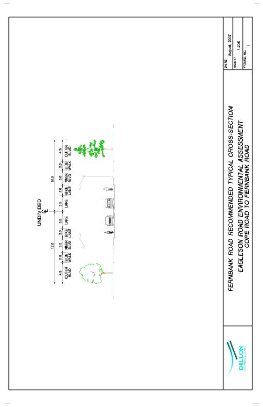
The typical two-lane cross-section with
on-street cycling lanes was selected as the preferred design for Fernbank Road.
The cross-section and the plan and profile drawings are presented in Document 2.
Common to both alternatives
were the consideration of several factors which required investigation and
subsequent incorporation into the conceptual roadway design, as discussed
below.
Multi-use
Path Crossings
A multi-use path adjacent to the Monahan
Drain will cross both Eagleson and Fernbank Roads. The crossing of Eagleson
Road is recommended to be at the signalized intersection with Bridgestone
Drive. The multi-use pathway crossing of Fernbank Road is recommended to be at
the Eagleson Road intersection. A
separate signalized crossing near the Monahan Drain is not recommended unless
signal warrants are met in the future.
Underpass crossings of Eagleson Road and Fernbank Road were investigated
but dismissed on the basis of feasibility, cost and impacts on the adjacent
development.
Drainage
Increased runoff due to the widening of
Eagleson Road, and changes to the cross-section (e.g., installation of a
median), will require modifications to the existing stormwater management
system on Eagleson Road within the study area. These changes were anticipated
during the design of the Monahan Drain Stormwater Management Ponds and
alterations to the design are not required.
Property
Requirements
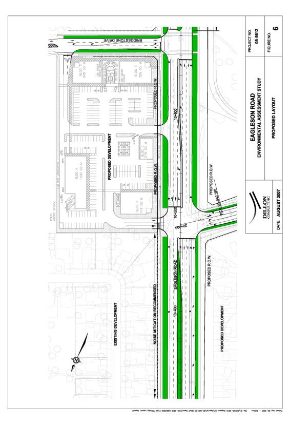
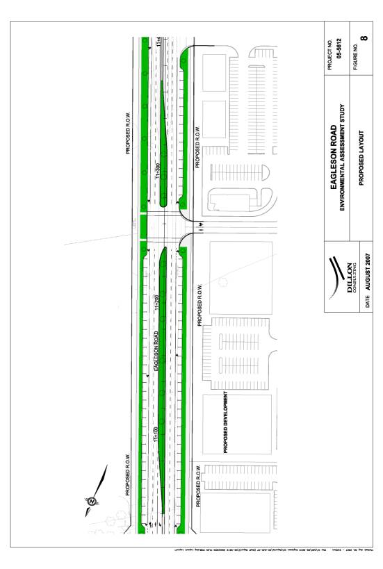
Incorporating an urban arterial mainstreet design (as identified in the Transportation Master Plan) for the widening of Eagleson Road, from Cadence Gate to Terry Fox / Hope Side Road, necessitates expanding the current Right-of-Way from 30 m to 44 m. The property on the west side of the road has been dedicated as part of the subdivision process, and has been coordinated with the site design process. Property will be required from adjacent agricultural lands on the east side of Eagleson Road with one property north of Hope Side Road and one property south of Hope Side Road. Additional property will be required on both the west side of Eagleson Road south of Hope Side Road.
Access
Controls
Widening Eagleson Road to include a
centre median and roundabout at Flewellyn Road will alter the existing
circulation patterns for vehicles and pedestrians. Signalized intersections with full movements exist or will be
provided at Cadence Gate/Cope Road, Fernbank Road, Bridgestone Drive (future),
Emerald Meadows/Romina Street (future), and Hope Side Road/Terry Fox Drive. One
full movement intersection is planned for the proposed employment and
commercial development on the west side of Eagleson Road between Romina Street
and Terry Fox Drive, which can be signalized when warranted.
Fernbank Road will have signalized crossings
at Terry Fox Drive (existing) and at Eagleson Road (existing). An unsignalized
intersection will be provided at Romina Street, which can be signalized when
warranted.
CITY STRATEGIC DIRECTIONS
The results of this study for Eagleson Road satisfies the following City Strategic Direction:
- Ensure that City infrastructure required for new growth is built or improved as needed to serve the growth.
ENVIRONMENTAL IMPLICATIONS
The natural environment conditions within the
study area were field inventoried and documented for use in the study
evaluation. The Monahan Drain is the major natural feature of the study and has
figured prominently in the development of study recommendations. Two important
issues relating to the Monahan Drain were the minimization of impact on the
in-situ aquatic and riparian habitat, and support to its use as a recreational
area.
The recommended alternative addresses both
issues by narrowing the roadway at the drain crossing. This avoids the cost to
extend a major culvert and the habitat disruption associated with that work.
Additionally, the route of the multi-use path and the Monahan Drain area have
been carefully integrated into the design of the associated paths, road-crossings,
access, etc.
The majority of the study area is comprised
of a landscape that has been previously transformed from a natural to an urban
state.
Noise
A noise assessment along the Eagleson Road
study area was performed according to the City
of Ottawa Environmental Noise Guidelines (2006). The sound levels at
sensitive receptors were estimated within two time frames: ambient (at the
commencement of construction) and future (mature state of development). The
sound level estimates were based on projected traffic volumes using the
Ministry of Environment road traffic model, STAMSON.
In summary, some of the receptors along
Eagleson Road produced future sound levels above 60 dBA, which is a threshold
that triggers the obligation to investigate noise mitigation. The predicted
levels were produced assuming a posted speed of 60 km/h.
The recommended noise mitigation
measure is the construction of noise barriers within the City right-of-way to
achieve required minimum levels of attenuation.
Noise barriers will be included in the
project for the sections of Eagleson Road (within the study area) with the
outdoor living area (residential rear yards or other noise sensitive land use)
adjacent to the road.
Within the Eagleson Road study area this is
confined to the east side of Eagleson Road from Cadence Gate to Fernbank
Road. All other areas do not contain
outdoor living areas adjacent to the roadway or will be addressed by new
developments as part of the subdivision process.
Air
Quality
In accordance with City Council direction, air quality is a factor to be evaluated and considered in all road projects undertaken within the city. Accordingly, an air quality evaluation was made for the Eagleson Road and Fernbank Road projects, in which the three major emissions from vehicles were considered: hydrocarbons (HC), carbon monoxide (CO) and oxides of nitrogen (Nox). Hydrocarbons and nitrogen oxides contribute to smog pollution. Carbon monoxide is a poisonous gas in closed spaces, but in the open and in vary large concentrations can also be toxic to animals and plants.
At this time, there are no standards in Ontario relating to vehicle exhaust emission levels from roadways. There are standards relating to emission levels from individual vehicles, but the cumulative effect of emissions from traffic on any given section of roadway is not regulated.
In 2021 with projected population growth (despite changes over time to vehicle emissions technology), increased traffic volumes will increase total emission quantities of carbon monoxide, oxides of nitrogen and hydrocarbons above the quantities that occur today, conditions will be similar to those experienced adjacent to many suburban arterial roads across the city (such as March Road, Hazeldean Road, Terry Fox Drive, and others).
A key
consideration in the development of the recommended plan for Eagleson Road has
been the rural to urban transition. The
recommended plan addresses the process of transitioning from the rural arterial
road environment, on Eagleson Road south of the urban area, into the lower
speed and higher activity area over 500m, from Flewellyn Road to Terry Fox
Drive.
Key features of the transition area are the roundabout intersection at Flewellyn Road that addresses reported turning delay and safety concerns, and gentle deflections of the roadway that correspond to the planned reductions in the posted speed.
CONSULTATION
Public
consultation began early in the process and was maintained throughout the
duration of the study. Input was gained from the public, affected property
owners and developers, local interest groups and review agencies in an effort
to help identify issues and constraints and to obtain comment on selected design
features. Over the course of the study, regular update meetings were held with
an Agency Consultation Group (ACG) and a Public Consultation Group (PCG) to
seek input, direction and concurrence on the study findings and
recommendations.
A proactive and flexible approach to public
and agency consultation was adopted in keeping with the needs and interests of
key stakeholders. Although the required points of public contact in the Class
EA are clearly stipulated, the issues/concerns and level of interest of the
stakeholders dictated the form and frequency of public contact.
The consultation program for this study
consisted of the following activities:
·
“Notice of
Project Commencement” advertisements in local newspapers (1 March 2006);
·
Three Public
Open Houses (4 April 2006; 22 June 2006; 27 June 2007);
·
Public
Consultation Group and Stakeholder meetings;
·
Agency
Consultation Group meetings;
·
General
Inquiries - Contact with various public stakeholders to respond to comments or
questions throughout the study.
The three
public open houses were informal drop-in sessions with the Project Manager from
the study team present to answer questions. The sign-in attendance at the three
open houses was 10, 18 and 20 persons respectively. Poster board presentations
were displayed at each open house. These boards contained both graphic and text
information pertaining to the study design, environmental assessment process,
conceptual plans, and next steps. Information sheets and copies of the boards
presented at previous open houses were available to members of the public, and
later posed on the City web site. Comment sheets were provided and feedback
encouraged. A summary of comments received is included in Table 1.
Summary of Public Comments
At the conclusion of the study, the generally
supportive responses were split between support for the proposed design
elements and specific reservations about certain roadway design features.
The principle issues of contention were:
1. Provision of on-street parking in accordance
with Urban Arterial design guidelines;
2. Speed reduction measures such as the
deflection of the horizontal roadway alignment and the traffic circle.
3. Noise levels experienced by property owners
adjacent to Eagleson Road (concern with historic and future noise levels) both
within and outside the study area.
Table
1 presents a summary of the public comments collected over the course of
the study. The comments were grouped according to common themes. The response
of the study team to the comment is also provided.
Table 1: Summary
of Public Comments
|
Widening Issues |
Response |
|
Support for the widening of Eagleson road from two lanes to four. |
Noted. |
|
Support for typical 4-lane arterial with bike lane provision. |
Noted. |
|
Support for road-widening between Cope Road & Fernbank Road due to dangerous merge on down hill slope. |
Noted. |
|
Pedestrian and Cycling Issues |
Response |
|
Support for sidewalks, bike lanes, and street lighting on both sides. |
Noted. |
|
Suggestion that recreational pathway be lowered and/or moved to improve privacy on residential property. |
Existing pathway is outside of the project study area but noise attenuation requirements may address this. |
|
Suggestion for 2 m bike lanes urban divide, signalized crossings, separated and signalized cycling pathway corridors. |
Noted. |
|
Concern with pedestrian crossing of Fernbank Road. |
Noted. |
|
Noise Issues |
Response |
|
Noted high noise levels and dust in back yard due to increase in traffic. Suggestion for installation of full sound barriers with trees and bushes for homes backing on to Eagleson Road. |
EA has recommended noise mitigation where warranted, with detailed impact mitigation to be addressed in the design phase. |
|
Support for full sound barriers behind homes on Riding Way and Huntsman. |
See above response. |
|
Question if sound barriers will be erected on east side of Eagleson Road between Cope Road and end of housing near Fernbank. |
See above response. |
|
Design Issues |
Response |
|
Prefers landscaped cross-section option with separate pedestrian path. |
Noted. |
|
Suggestion that connecting roadways from Eagleson to TFD be constructed as part of the Eagleson Road work (i.e. Cope and Michael Cowpland Roads). |
Roadways will be provided as adjacent lands develop. |
|
Suggestion for maximum speed of 60km/h, use of yield signs (in lieu of stop signs) use of pedestrian signals with countdown times, use of traffic circles (in lieu of traffic signals), use of protected and permissive left turn signals (in lieu of protected), and removal of all-red time at traffic signals. |
Noted, but some suggested changes are bound by traffic engineering design parameters and will be determined in the detailed design. |
|
Suggestion to remove right turn channeling and provide left turn channeling (single lane). |
Noted, design supports narrower Right-of-Way. |
|
Concern regarding traffic circle and alignment deflection design. |
Noted, speed management measures are critical to the safe implementation of Mainstreet features and, therefore, have been retained. |
|
Concern with allowance for on-street parking. |
Noted but design supports City of Ottawa Arterial Mainstreet guidelines. (Approved by City Council on May 24, 2006) |
|
Suggestion to design medians and roadway with adequate provision for snow and water run-off and capture. |
Noted. |
|
Timing Issues |
Response |
|
Suggestion that Trans Canada Trail way-finding signage be installed before proceeding with this project. |
Noted. |
|
Traffic Issues |
Response |
|
Concern about increasing traffic volumes on Eagleson Road. |
Consideration was given to planned developments within and adjacent to the study area. Anticipated traffic volume increases are a direct result of growth and approved development. |
|
Concern about potential increase in traffic volumes on Emerald Meadows Drive with the development of Shillington lands. Noted that traffic in Bridlewood is currently heavy and additional vehicles will compound the problem. |
See above response. |
|
Request that effort be made to maximize traffic flow and minimize delay. |
Noted. |
|
Support for posted speed limit of 50 kph. |
Noted. |
|
Concern that decreasing posted speed limit lengthens travel time required to exit city. |
The proposed speed limit of 60km/h corresponds to the 70km/h design speed of the roadway, and the Arterial Main Street function. |
|
Other Issues |
Response |
|
Concern about future Shillington developments and whether there is opportunity for change. |
Not within the scope of the study. Comment referred to Planning Approvals for review within the Site Plan process. |
|
Suggestion that parking lot be provided in the Monahan Drain. |
Noted, under review by Parks and Recreation. |
|
Suggestion that stand of trees located on south-west corner of Eagleson Road and Fernbank Road is preserved. |
Noted. |
Project Web Site
A website was maintained for this project on
the City’s external website. It contained all public notices and display
materials presented at the three open houses.
http://www.ottawa.ca/public_consult/eagleson/index_en.shtml
This gave interested members of the community
who were unable to attend the scheduled events an opportunity to view all the
materials at their convenience. The web-site also included contact information
for the study team.
Members of the public who signed in at the open houses or who expressed interest in the study were placed on the study mailing list. Where email addresses were provided interested parties were sent email advising them of new materials posted on the website.
FINANCIAL IMPLICATIONS
·
Eagleson
Road (from Cadence Gate / Cope Road to Terry Fox Drive / Hope Side Road)
reconstruction and widening with a design incorporating a four-lane urban
arterial divided cross-section, bicycle lanes and on-street parking is expected
to cost approximately $11 M ($2007) for 2.0 km.
·
Fernbank Road
(from Terry Fox Drive to Eagleson Road) reconstruction to a two-lane urban
arterial cross-section is expected to cost approximately $3.5 M ($2007) for 0.6
km.
- The Capital Budget Forecast 2008-2016
identifying Eagleson Road (Cadence Gate to Hope Side Road), project
901021, with $9M in the 2011-2016 timeframe will require adjustment to
$11M and extension of the project limits to Flewellyn Road.
SUPPORTING DOCUMENTATION
Document
1 Eagleson Road: Typical Cross-Section, and
Plan Drawings
Document 2 Fernbank Road: Typical Cross-Section, and Plan Drawings
DISPOSITION
Following Committee and Council approval, the Environmental Study Report documenting the entire EA process and study recommendations will be finalized and provided to the public for a 30 day review period. The public will be notified through the posting of a ‘Notice of Study Completion” appearing in the Ottawa Citizen, Le Droit, and the Kanata Kourier newspapers.
EAGLESON ROAD: TYPICAL CROSS-SECTION, AND
PLAN DRAWINGS DOCUMENT
1