|
2. ZONING – 123
Huntmar Drive ZONAGE – 123, PROMENADE HUNTMAR |
Committee recommendationS
(This application is not subject
to Bill 51
That Council approve the following amendment:
a)
The land known as 123 Huntmar Drive be deleted
from the former Township of West Carleton Zoning By-law 266 of 1981 zoning map
and the lands no longer be subject to By-law 266 of 1981;
b)
The
land known as 123 Huntmar Drive be incorporated into the former Township of
Goulbourn Zoning By-law 40-99 zoning map and be subject to the provisions of
By-law 40-99;
c)
The
land known as 123 Huntmar Drive be zoned R1-21 (Residential Type One Special
Exception 21) as shown in Document 1 and detailed in Document 3; and
d)
Part of the land known as 123 Huntmar Drive be
zoned R1-21 (T1) (Residential Type One Special Exception 21 Temporary Use One
Zone) shown as Area A in Document 1 and as detailed in Document 3.
RecommandationS du Comité
(Cette demande n’est
pas assujettie au Règlement 51)
Que le Conseil municipal approuve
la modification suivante:
a)
que
le terrain au 123 de la promenade Huntmar soit rayé de la carte de zonage
établie en vertu du Règlement municipal sur le zonage 266 de 1981 de l'ancien
Canton de West Carleton et ne soit plus assujetti aux dispositions de ce
règlement;
b)
que
le terrain au 123 de la promenade Huntmar soit ajouté dans la carte de zonage
établie en vertu du Règlement municipal sur le zonage 40-99 de l'ancien Canton
de Goulbourn et assujetti aux dispositions de ce règlement;
c)
que
le terrain au 123 de la promenade Huntmar soit zoné R1-21 (zone résidentielle
de type 1, exception spéciale 21), selon ce qui est indiqué dans le document 1
et montré en détail dans le document 3;
d)
qu'une
partie du terrain au 123 de la promenade Huntmar soit zonée R1-21 (T1) (zone
résidentielle de type 1, exception spéciale 21, utilisation temporaire 1),
selon ce qui est indiqué par l'aire A dans le document 1 et montré en détail
dans le document 3.
Documentation
1.
Deputy
City Manager's report Planning, Transit
and the Environment dated 10 September 2007 (ACS2007-PTE-APR-0171).
Report to/Rapport au :
Planning and Environment Committee
Comité de l'urbanisme et de l'environnement
and Council / et au Conseil
10 September 2007/10 septembre 2007
Submitted by/Soumis par : Nancy Schepers, Deputy City Manager
Directrice municipale adjointe,
Planning, Transit and the Environment
Urbanisme, Transport en commun et Environnement
Contact
Person/Personne Ressource : Grant Lindsay, Manager / Gestionnaire,
Development Approvals / Approbation des demandes d'aménagement
(613)
580-2424, 13242 Grant.Lindsay@ottawa.ca
|
SUBJECT: |
|
|
|
|
|
OBJET : |
REPORT RECOMMENDATIONS
That the Planning and Environment Committee recommend Council approve the following amendment:
a)
The land known as 123
Huntmar Drive be deleted from the former Township of West Carleton Zoning
By-law 266 of 1981 zoning map and the lands no longer be subject to By-law 266
of 1981;
b)
The
land known as 123 Huntmar Drive be incorporated into the former Township of
Goulbourn Zoning By-law 40-99 zoning map and be subject to the provisions of
By-law 40-99;
c)
The
land known as 123 Huntmar Drive be zoned R1-21 (Residential Type One Special
Exception 21) as shown in Document 1 and detailed in Document 3; and
d)
Part of the land known as 123 Huntmar Drive be
zoned R1-21 (T1) (Residential Type One Special Exception 21 Temporary Use One
Zone) shown as Area A in Document 1 and as detailed in Document 3.
RECOMMANDATIONS DU RAPPORT
Que le Comité de l'urbanisme et de
l'environnement recommande au Conseil d'approuver la modification suivante :
a)
que
le terrain au 123 de la promenade Huntmar soit rayé de la carte de zonage
établie en vertu du Règlement municipal sur le zonage 266 de 1981 de l'ancien
Canton de West Carleton et ne soit plus assujetti aux dispositions de ce
règlement;
b)
que
le terrain au 123 de la promenade Huntmar soit ajouté dans la carte de zonage
établie en vertu du Règlement municipal sur le zonage 40-99 de l'ancien Canton
de Goulbourn et assujetti aux dispositions de ce règlement;
c)
que
le terrain au 123 de la promenade Huntmar soit zoné R1-21 (zone résidentielle
de type 1, exception spéciale 21), selon ce qui est indiqué dans le document 1
et montré en détail dans le document 3;
d)
qu'une
partie du terrain au 123 de la promenade Huntmar soit zonée R1-21 (T1) (zone
résidentielle de type 1, exception spéciale 21, utilisation temporaire 1),
selon ce qui est indiqué par l'aire A dans le document 1 et montré en détail
dans le document 3.
BACKGROUND
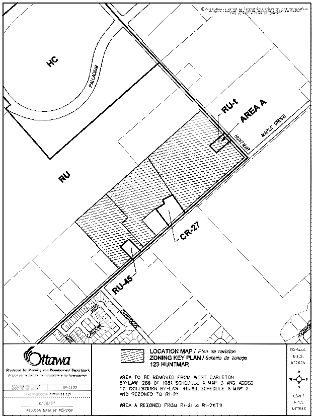
The property is 22.39 hectares in size and is located within the southwest quadrant of the Kanata West Concept Plan boundary (see Document 1). The lands are located north of Maple Grove Road, west of the existing Huntmar Drive and south of the proposed North-South Arterial roadway. The municipal address is 123 Huntmar Drive.
The Zoning By-law amendment
application requests that the zoning be changed from the existing Rural (RU)
zone to a “residential mixed unit” zone. The purpose of this rezoning is to
implement the draft approved subdivision and to permit a flexible range of ground-oriented,
medium-density residential dwelling types, neighbourhood parks and an
elementary school. The proponent is requesting that this subdivision, known as
Fairwinds North, be zoned the same as their adjacent subdivision Fairwinds
South, but that new zone provisions be introduced into the By-law to allow for
the construction of a new form of housing, “Back to Back” Street Townhomes and
to recognize that a sales office presently exists on site on a temporary basis.
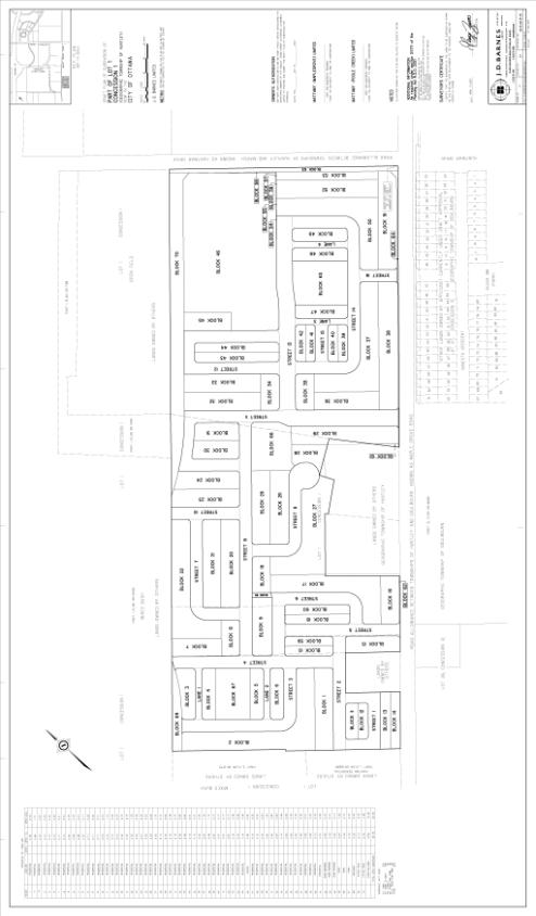
The companion subdivision application
was draft approved on June 27, 2007 (see Document 2). When registered, the
subdivision will subdivide the subject lands to create a residential
development of approximately 560 units that will include detached,
semi-detached, street townhouse, street townhouse on a rear lane and “back to
back” street townhouse units, as well as, three neighborhood parks. The
proposal also includes a block at the intersection of Huntmar Drive and the
future North-South Arterial
roadway to accommodate
a future elementary school. Main road
access will be provided by Maple Grove Road and Huntmar Drive with future
connections to the North-South
Arterial roadway and the Stittsville Main Street extension.
DISCUSSION
The subject application has been examined
pursuant to the provisions of the Official Plan, and the Kanata West Concept
Plan.
The Official Plan designates the property General Urban Area. The General Urban Area designation permits the development of a full range and choice of housing types to meet the needs of all ages, incomes and life circumstances. The draft plan of subdivision is comprised of a number of residential blocks that will accommodate a range of unit types including single detached, semi detached, street townhouses, street townhouses on public rear lanes and back to back street townhouses. The Zoning By-law amendment as proposed would permit this range of unit types within one zone to be applied to the subdivision lands.
In the Kanata West Concept Plan (KWCP), the lands are shown as “Residential B”. This residential land use area is to permit a range of residential dwelling types in a transit-integrated and pedestrian friendly environment. Urban residential densities are encouraged throughout the residential areas. These densities are higher than typical suburban residential areas and are more in keeping with post-war communities such as Ottawa South and the Glebe. The direction of the KWCP is that the residential development adjacent to the existing residential neighbourhoods, Bryanston Gate and Joseph Circle will be low density single detached housing and that development will transition to higher density as it moves towards the central mixed use land use area. In keeping with this vision, the density reflected in the Fairwinds North subdivision plan and implemented through this proposed By-law is higher and the housing type more innovative and diverse than the Fairwinds South subdivision and other lands to the south east.
Details of Proposed Zoning
The proponent is requesting that the residential portion of the site be zoned a single zone which permits singles, semis and townhouses. This approach recently has been considered and approved by Council through the rezoning of the Fairwinds South subdivision located south of the subject lands and the Jackson Trails Subdivision located further to the east along Hazeldean Road. This approach to residential zoning has also been in place for some time in other areas of the city namely; former Gloucester, Nepean and Kanata.
This approach, in theory, would allow for the residential area of the subdivision to be developed entirely as large lot single detached homes. This would not meet the policies of the General Urban Area of the Official Plan nor the intent of the Kanata West Concept Plan both of which encourage denser development to make efficient use of public infrastructure and encourage transit use. The intent of the proponent is, in fact, to have a mix of all five housing types. This is also what was presented to the community in the public meeting and the information and comment session. Similar to the zoning applied to Fairwinds South, staff is recommending that the zone to be applied to this land, contain a provision requiring a density minimum of 29 units per net hectare. This density is the same as that applied to those areas designated “Developing Communities” in the Official Plan. The appropriate density and mix of units is further controlled through the subdivision registration process.
The application is also proposing to add provisions to apply to “Back to Back” street townhomes, a housing product that is unique to the developer and had not been anticipated when the former Township of Goulbourn Zoning By-law was formulated. Similar to street townhomes “Back to Backs” front on a public street but have no rear yard. Interior lots have a common wall on either side, as well as, the rear wall. A definition of this new form of housing is to be added to the Zoning By-law as part of this Zoning By-law amendment. The new provisions that have been developed for this form of housing are the same as street townhouses with respect to frontage, front yard and interior and exterior side yard depths, however, no minimum rear yard is required.
The Kanata West Concept Plan outlines general design principles, as well as, those specific to each land use category. A number of these are implemented through this proposed zoning. Higher densities than traditional suburban areas will be achieved because the residential zone allows for a mix of residential dwelling types, including medium and small lot single-detached and semi-detached houses and townhouses. The zone also permits two types of street townhomes that are new to Ottawa; street townhouses on a “public rear lane” and “Back to Back” street townhomes. Improving the streetscape and reducing the need for noise barrier fences along major spine roads is achieved by permitting townhouses on rear lanes. A close relationship between the house and street is achieved by permitting front yard setbacks smaller than that of traditional suburban communities and requiring that garages be either setback from, or flush with the building face. This zone also includes zoning provisions which will allow for wrap around porches into exterior sideyards.
Neighbourhood Parks
The subdivision layout includes
three small neighbourhood parks. Staff is proposing to add “Park” as a permitted use
to the residential zone, which will apply to this subdivision. This will allow
for minor changes to be made to the plan without going through a rezoning by-law
amendment process. Any major changes to the plan would require an application
to revise the draft plan of subdivision.
School
A block has been set aside in the plan of
subdivision for a future elementary school at the corner of Huntmar Drive and the
future North South Arterial. Under the Goulbourn Zoning By-law elementary
schools are permitted in all residential zones as a “public use”. Similar to
the elementary school block in Jackson Trails, staff are recommending that the
school block be zoned residential similar to the surrounding draft approved
residential area. In this way, should the Ottawa Catholic School Board decide
not to build a school in this location, then a Zoning By-law application will
not be required to “permit” residential development. Either a revision to the
draft plan of subdivision or a site plan control application would however, be
required prior to any residential development proceeding.
Office (Temporary Use)
A small portion of the subject lands fronting
on Huntmar Drive is presently zoned for a temporary use to permit an office.
The owner is presently using the existing building for office use.
These lands have been incorporated into the
draft approved subdivision and once the office is no longer needed the
buildings will be demolished and the lands incorporated into the surrounding
subdivision. The subject Zoning By law amendment will permit this temporary use
to continue.
Conclusion
Staff are recommending the
approval of the Zoning By-law amendment as detailed in Document 3. The subject application is in
conformity with the applicable Official Plan policies associated with the above
noted Official Plan designations and the land use provisions of the Kanata West
Concept Plan.
This by law also provides an opportunity to realize certain design objectives of the Official Plan and the Kanata West Concept Plan and will implement the draft plan of subdivision. The zoning to be applied to these lands is very similar to that applied to the adjacent Fairwinds South subdivision with the exception of the addition of Back to Back Street Townhomes, and Park as permitted uses and the continuation of the office use as a temporary use.
CONSULTATION
Notice of this application was carried out in accordance with the City's Public Notification and Consultation Policy. The Ward Councillor is aware of this application and the staff recommendation. Comments received from the public are outlined in Document 3.
FINANCIAL IMPLICATIONS
APPLICATION PROCESS
TIMELINE STATUS
The application was not processed by the
"On Time Decision Date" established for the processing of Zoning
By-law amendments due to issues related to the draft plan of subdivision
application. These have been resolved and the subdivision is now draft
approved.
SUPPORTING DOCUMENTATION
Document 1 Location
Map
Document 2 Draft
Plan of Subdivision
Document 3 Details
of Recommended Zoning
Document 4 Consultation Details
DISPOSITION
City Clerk’s Branch, Council and Committee Services
to notify the owner, Matt Kingston, Mattamy Homes, 123 Huntmar Drive, Ottawa ON
K0A applicant, Miguel Tremblay, Fotenn Consultants, 223 MacLeod Street, Ottawa
ON K2P 0Z8 OttawaScene.com, 174 Colonnade Road, Unit #33, Ottawa,
ON K2E 7J5,
Ghislain Lamarche, Program Manager, Assessment, Financial Services Branch (Mail
Code: 26-76) of City Council’s
decision.
Planning, Transit and the Environment
Department to prepare the implementing by-law, forward to Legal Services Branch
and undertake the statutory notification.
Legal Services Branch to forward the
implementing by-law to City Council.
LOCATION MAP DOCUMENT
1
DRAFT PLAN OF SUBDIVISION DOCUMENT
2