CANDIDATE PROJECTS – CITY WIDE OVERVIEW DOCUMENT 1
|
2. Near-Term transit
Investment Options Options d’investissement à court terme dans le transport
en commun |
joint CommitteeS’ recommendations as amended
That Council:
1. Approve
that the list of projects in Table 1 of the report on Near-Term Transit Investment
Options be modified as follows and be approved as priorities for implementation
in the near future:
i)
Fund the Transitway from Bayshore to Moodie drive
ii)
Fund the Transitway from Woodroffe to Bayshore as
soon as the EA is finalized as per the recommendation in the Rapid Transit
Environmental Assessment report is completed
iii)
That the following proposed City-Wide Transit
projects be recommended to Council for approval:
·
Smart Card -
$ 15 Million
·
New Bus Garage -
$ 60 Million
·
Transit Fleet Acquisition (2009) - $ 46 Million
And,
under the Central Area / Inside the Greenbelt,
Central
Area Station Improvements - $
5 Million
iv) That Federal and
Provincial infrastructure funding be sought for the Strandherd-Armstrong Bridge
and related roadwork
v) That
prior to approving any of the other projects in Table 1, the Committee receive
the staff report on the Urbandale proposal.
2.
Direct staff to enter into discussions with the Federal
and Provincial agencies to negotiate funding for these priority projects and
report back to Committee on the status of these negotiations and funding
availability and financial implications, and further that the funding sought
from senior governments be identified as transit-specific funding or road
network-specific funding, and specify the sharing that is assumed for any
transportation components that are intended to serve both modes.
3. With respect to the Urbandale Report, direct staff to
report back to the Committee by October 2007 on the appropriateness of the
corridors, recommendations on modifications of the corridors including
expansion to Kanata and across the Strandherd Bridge to Barrhaven, and a
timetable to undertake any additional or modifications of studies to implement
such a network.
Recommandations modifiÉes dES ComitÉS conjoints
Que
le Conseil :
1. Permise
que la liste des projets figurant au tableau 1 du rapport sur les options
d’investissement à court terme dans le transport en commun soit modifiée comme
suit et soit approuvée à titre de priorité de mise en œuvre prochainement :
(i) Financer le Transitway de Bayshore à
la promenade Moodie
(ii) Financer le
Transitway de Woodroffe à Bayshore dès que l’ÉE sera terminée conformément à la
recommandation à venir dans le rapport d’évaluation environnementale du
transport en commun rapide
(iii) Que les projets de
transport en commun à l’échelle de la ville qui suivent soient recommandés au
Conseil pour approbation :
·
Carte
à puce -
15 millions de dollars
·
Nouveau
garage pour les autobus -
60 millions de dollars
·
Acquisition
de véhicules de transport en commun
(2009) -
46 millions de dollars
Et, pour le centre-ville/la ceinture
de verdure, améliorations de la station du centre-ville -
5 millions de dollars
(iv) Que des fonds fédéraux et provinciaux
au titre des infrastructures soient sollicités pour le pont Strandherd-Armstrong et les travaux routiers
connexes
(v) Qu’avant d’approuver
tout autre projet figurant au tableau 1, le Comité reçoive le rapport du
personnel sur la proposition d’Urbandale.
2. enjoigne le personnel d’entamer des
négociations avec les organismes des gouvernements fédéral et provincial afin
de négocier le financement de ces priorités et de faire rapport au comité sur
l’état de ces négociations, de la disponibilité du financement et des
répercussions financières, et ordonner que le financement sollicité des
échelons supérieurs de l’administration publique soit destiné au transport en
commun ou au réseau routier et que soit précisée la quote-part assumée pour
toute composante de transport visant à desservir les deux moyens de transport.
3. Concernant
le rapport d’Urbandale, enjoigne le personnel à faire rapport au Comité au plus
tard en octobre 2007 sur l’opportunité des couloirs, sur les
recommandations de modification des couloirs, y compris le prolongement jusqu’à
Kanata et jusqu’à Barrhaven par le pont Strandherd, et sur un échéancier pour
toute étude supplémentaire ou toute modification aux études en vue de la mise
en œuvre d’un tel réseau.
Documentation
1.
Deputy City Manager, Planning, Transit and the
Environment report
dated 26 July 2007 (ACS2007- PTE-POL-0050).
2.
Extract
of the Draft Joint Minutes 3, Transportation Committee and Transit Committee,
15 August 2007 (To be distributed separately prior to Council).
Report to / Rapport au :
Joint Meeting - Transportation
Committee/Transit Committee
Réunion conjointe du Comité des transports et du
Comité du transport en commun
26 July 2007 / 26 juillet 2007
Submitted by / Soumis par : Nancy Schepers, Deputy City Manager / Directrice
municipale adjointe,
Planning, Transit and the Environment/
Urbanisme, Transport en commun et Environnement
Contact Person / Personne-ressource
: Vivi Chi, Manager, Transportation and Infrastructure Planning / Gestionnaire,
Transports et planification des infrastructures
Planning Branch / Direction de l’urbanisme
(613) 580-2424, ext. / poste 21877,
vivi.chi@ottawa.ca
|
SUBJECT: |
|
|
|
|
|
OBJET : |
Options d’investissement à court terme dans
le transport en commun |
REPORT RECOMMENDATIONS
That the Joint Transportation and Transit Committee recommend Council:
1. Approve the list of transit projects (Table 1) as priorities for implementation in the near future.
2. Direct staff to enter into discussions with the Federal and Provincial agencies to negotiate funding for these priority projects and report back to Committee on the status of these negotiations and funding availability and financial implications.
RECOMMANDATIONS DU
RAPPORT
Que le Comité conjoint du Comité des transports
et du transport en commun recommande au Conseil :
1. d’approuver
la liste des projets de transport en commun (tableau 1) à titre de
priorités de mise en œuvre à court terme;
2. d’enjoindre le personnel d’entamer des négociations avec les organismes des gouvernements fédéral et provincial afin de négocier le financement de ces priorités et de faire rapport au comité sur l’état de ces négociations, de la disponibilité du financement et des répercussions financières.
EXECUTIVE
SUMMARY
Assumptions
and Analysis:
This report proposes transit projects that can be implemented in the near-term to address existing and future demand of quickly developing communities across the city. The proposed projects are listed in Table 1.
The majority of these projects have a long history of need and are identified in the current Official Plan (OP), the Transportation Master Plan (TMP), and other past planning documents. These transit and transit-supportive road projects stand the best chance of getting funding from higher levels of government due to their state of readiness for implementation (planning and environmental assessment studies are complete) and the quick benefits that they would bring to the city.
Multi-use pathways will be incorporated into each of the projects as appropriate, in accordance with the policies stated in the OP and TMP. Promoting implementation of transportation projects such as transit and facilities with sidewalks and cycling lanes help the City manage its growing transportation demand in a sustainable manner.
In developing this list of projects, the Mayor’s Task Force’s Report and the City’s Strategic Directions were considered. Table 2 of the report summarizes the Task Force’s recommendations pertaining to immediate and short-term projects and a brief outline of how these recommendations will be addressed. The governance issue for Transit Services is the subject of a separate report and as such is not noted in the summary.
At present, there are no new road or transit funding programs being offered by the upper-tier governments. There is potential that funds, which had been set aside by these agencies for the North-South LRT project, could be redirected to the priority projects that Council endorses. This proposal is subject to further detailed discussions and agreements with the Federal and Provincial governments.
Financial Implications:
There are no financial implications as a result of the approval of this report. Following negotiations with the Federal and Provincial agencies, staff will report back to Committee on the availability of funding mechanisms and the full financial implications of these projects with respect to development charges and tax supported reserves.
Public Consultation/Input:
No public consultation was undertaken for the preparation of this report.
RÉSUMÉ
Hypothèses et analyse :
Dans le présent rapport, on propose des projets
de transport en commun qu’il est possible de mettre en œuvre à court terme afin
de répondre aux besoins actuels et ultérieurs des collectivités en plein essor
dans la Ville. Les projets proposés sont répertoriés au tableau 1.
La plupart de ces projets répondent à des
besoins de longue date et sont relevés dans le Plan officiel (PO) actuel, le
Plan directeur des transports (PDT) et d’autres documents de planification
parus antérieurement. Compte tenu que ces projets ayant trait au transport en
commun et à la construction routière ou qui les favorisent peuvent être mis en
œuvre sans délai (les études de planification et d’évaluation environnementale
qui s’y rapportent sont terminées) et que la Ville peut en tirer des avantages
immédiats, les probabilités de financement des ordres de gouvernement
supérieurs sont excellentes.
Au besoin, des sentiers polyvalents seront
intégrés à chacun des projets, conformément aux politiques énoncées dans le PO
et le PDT. Le fait de favoriser la mise en œuvre de projets de transports qui
font place au transport en commun ou à l’aménagement de trottoirs et de pistes
cyclables permet une gestion municipale viable de la demande croissante en
matière de transports.
Dans les projets qui sont répertoriés, les
orientations stratégiques de la Ville et le rapport du Groupe de travail du
maire sont pris en compte. Dans ce dernier rapport, le tableau 2 montre en
résumé les recommandations du Groupe de travail du maire par rapport aux
projets immédiats et à court terme, puis donne un aperçu succinct des suites à
donner à ces recommandations. Quant à la question de gouvernance des Services
de transport en commun, elle fait l’objet d’un rapport distinct; le présent
résumé n’en fait pas état.
À l’heure actuelle, les échelons supérieurs de
l’administration publique n’offrent pas de nouveaux programmes de financement
quant à la construction de routes ou au transport en commun. Il se peut que le
financement que les organismes souhaitaient consacrer au projet de tronçon
nord-sud du TLR soit redirigé vers les projets prioritaires que le Conseil
entérine. La présente proposition est exposée aux discussions et ententes
détaillées ultérieures de la Ville auprès des gouvernements fédéral et
provincial.
Répercussions financières :
L’approbation du présent
rapport n’entraîne aucune répercussion financière. À la suite des négociations avec
les organismes des gouvernements fédéral et provincial, le personnel fera
rapport au comité quant à la disponibilité de mécanismes de financement et à
toutes les répercussions financières de ces projets en matière de redevances
d’aménagement et de réserves financées par les recettes fiscales.
Consultation publique / commentaires :
La préparation du présent rapport n’a fait
l’objet d’aucune consultation publique.
Following the termination of the North-South LRT contract award on 14 December 2006, the City faces the need to develop alternative transportation action plans to address existing and future travel demand of the quickly developing south urban communities (primarily Riverside South and Barrhaven). Recent census data shows that from 1991 to 2006 the population of Barrhaven has grown from around 22000 to over 57000 residents and Riverside South has grown from just 710 to over 7600 residents. Ultimately, at its full build-out the population of the south urban community is expected to grow to 172000 while the number of jobs in the area is expected to grow to 70000. The population growth in the south urban community is expected to be the highest among all areas located outside the Greenbelt.
On 17 January 2007, Transit Committee approved a report that described a number of transit-related capital projects proposed as short-term opportunities to enhance customer service and serve growth pressures throughout the city while the anticipated longer-term review by the Mayor’s Task Force takes place.
On 20 June 2007, a report on issues and opportunities for implementing the Strandherd-Armstrong Bridge was presented to Transportation Committee to respond to Councillor Desroches’ motion of 28 March 2007. Committee and Council approved the report recommendation to get underway with the design for the Bridge this year and incorporating transit lanes as appropriate.
Meanwhile, the City is undertaking the review and update of its Official Plan (OP) and Transportation Master Plan (TMP). This process will be completed early in 2009. It includes consultation to capture the public’s comments on transit planning principles and vision for the City’s transit network. Need and justification for the resulting transit and road network corridors will be documented, along with costs, and a priority plan.
In addition, on 6 June 2007, the Mayor presented the findings of his Task Force on Transportation. The recommendations were grouped into priorities such as immediate, short-term, medium-term, and long-term implementation. While a list of decision criteria was included, the Task Force did not have sufficient time to undertake ridership studies (for the needs, justification, and priority setting analyses) nor were cost estimates developed for its recommendations. A review and analysis of the Task Force recommendations will be part of the TMP update, allowing for public and agency feedback. There are however, projects that were recommended by the Task Force that are already in the current TMP and could be considered for near-term implementation as their needs and justifications already have been addressed through their respective environmental assessment studies.
Also, on 11 July 2007 Council approved the 2007-2010 City Strategic Directions report which included a listing of service priorities for transportation (roads and transit). One of these priorities is to complete the construction of the Transitway by 2015.
This report is a follow-up to the 17 January 2007 report and considers the latest strategic developments since. A collection of transit investments is proposed that the City could implement in the short-term, while at the same time leaving options open for the City to consider longer-term projects proposed by the Mayor’s Task Force and other infrastructure projects that may be recommended through the update of the TMP and OP.
The timing for these projects to be in operation depends on a variety of issues: project complexity, funding availability, external approvals for design, ability of the consulting and construction industries to undertake all of the projects at once, etc. While some of the proposed projects are further along in design than others, it is possible that most of these projects can be in operation between now and five years provided that funding and approvals were all in place.
Initially, staff focussed attention on finding solutions for improving transit service to the south urban communities as a near-term and or interim replacement for the North-South LRT project. The effort to identify near-term transportation projects was then expanded to areas across the city that are also facing transportation capacity deficiencies, namely east and west linkages. Candidate projects had to be “ready” for implementation, meaning that the planning work (such as environmental assessment studies) had to have been completed and approved.
The majority of these project candidates have a long history of need and are identified in the current Official Plan, Transportation Master Plan, as well as in past planning. Some of them are also identified in the Mayor’s Task Force recommendations. These transit and transit-supportive roads projects would stand the best chance of getting funding from higher levels of government due to their state of readiness for implementation and the quick benefits that they would bring to the city. For some of these projects, design is already underway, but funding is required for construction. For others, the planning work is completed and funding for implementation is required for design and construction. For the purposes of this report both types of projects are identified, as they will form the basis for seeking funding contributions from senior levels of government.
At present, there are no new road or transit funding programs being offered by the upper-tier governments. There is a potential that funds, which had been set aside by these agencies for the North-South LRT project, could be redirected to the priority projects that Council endorses. This proposal is subject to further detailed discussions and agreements with the Federal and Provincial governments.
Longer-term initiatives as proposed by the Mayor’s Task Force require detailed planning/evaluation and need to be considered in the context of the overall transportation (roads and transit) network – which would be undertaken in the TMP review. Once included in the updated TMP, environmental assessments would need to be carried out and business cases developed in order to seek funding from the provincial and federal governments.
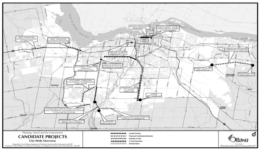
Given the considerations above, the proposed candidate projects are listed in Table 1. Document 1 shows the location of the individual facilities.
|
Preliminary Estimate ($M) |
Project
Description |
|
|
South
Urban Community
|
|
45 |
O-Train Extension to
Leitrim Park and Ride |
|
48 22 35 |
Strandherd-Armstrong Bridge
(with Transit) Earl Armstrong Road Widening (River
Road-Limebank) Strandherd Drive (Woodroffe - Prince
of Wales) |
|
12 |
Two Park and Ride Lots
(River Road, Leitrim) |
|
10 |
Transit Priority/Facilities
(Strandherd-Armstrong Bridge - Woodroffe Station - Fallowfield Station) |
|
85 |
Southwest Transitway
Extension (Fallowfield-Barrhaven Town Centre) |
|
30 |
Southwest Transitway
(Norice-Baseline Station) |
|
|
|
|
|
West
Urban Community |
|
33 |
West Transitway Extension
(Bayshore Station-Moodie Drive) |
|
64 |
West Transitway Extension
(Eagleson-Terry Fox) |
|
|
|
|
|
East
Urban Community
|
|
70 |
Cumberland Transitway
(Navan Road-Trim Road) |
|
10 |
2 Park and Ride Lots
(Chapel Hill South, Millennium Park) |
|
|
|
|
|
Central
Area/Inside the Greenbelt |
|
5 |
Central Area Station
Improvements |
|
5 |
Rideau Street
Transit Improvements (Sussex-King Edward)
|
|
8 |
Baseline-Heron Transit
Priority |
|
5 |
Pedestrian Bridge (Baseline
Station-Algonquin College) |
|
|
|
|
|
City-Wide/Other |
|
2 |
General Transit Stop
Improvements |
|
15 |
SmartCard |
|
2 |
Transit-oriented Rural
Pathway linkages |
|
60 |
New Bus Garage |
|
46 |
Transit Fleet Acquisition
(2009) |
|
$ 612M* |
Total |
*Estimates based on 2007
dollars. Projects shall be escalated in accordance with construction price
index for the purposes of future Capital budget submissions.
Multi-use pathways will be incorporated into each of the above-noted projects as appropriate, in accordance with the policies stated in the OP and TMP. Promoting implementation of transportation projects such as transit and facilities with sidewalks and cycling lanes help the City manage its growing transportation demand in a sustainable manner.
The projects are briefly described below.
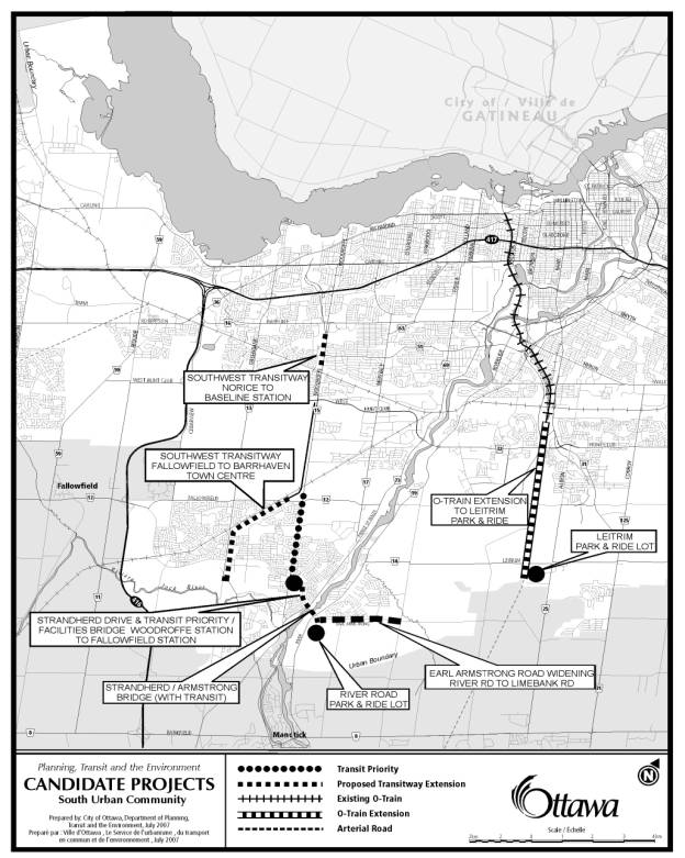
South Urban Community
These projects are shown in Document 2.
The O-Train Extension to Leitrim Park and Ride Lot was identified in a report to Transit Committee on 16 May 2007 as a possible future solution to alleviate the need for additional bus service on Slater Street in the afternoon peak period. In addition, commuters travelling from southern communities will have access to transit at the Leitrim Park and Ride Lot, which will also relieve current demand pressures at the Greenboro Park and Ride Lot. Approximately five kilometres of existing railway track from Greenboro Station will need to be upgraded and 0.6 kilometres of new tracks to be installed to take the line to the Leitrim Park and Ride Lot. Two new rail transit stations are introduced: South Keys and Leitrim. There would be at-grade crossings of Lester and Leitrim Roads, which will require the installation of signals and communications hardware and some associated roadworks. An additional train is needed to maintain the current 15-minute headway and modifications to the existing Maintenance Facility are required to accommodate the supplementary train. The project will include a pedestrian connection from South Keys Station to the community west of the Airport Parkway in the vicinity of Cahill Drive West/Plante Drive. Enhancements to other existing O-Train stations are not included in the estimated project cost.
An
amendment to the North-South Corridor LRT Project EA Study will have to be
completed for both provincial and federal EA processes. There are no funds identified for this
project in the Long Range Financial Plan.
Other issues relate to the natural habitat of the Blandings Turtle
(species at risk), local recreational access to green space open lands,
Transport Canada approvals for the trains to cross Lester and Leitrim Roads,
options to connect South Keys Station to the community west of the Airport
Parkway, and improvements to roads connecting Riverside South to the Leitrim
Park and Ride Lot. Bombardier has
confirmed that they are not able to reproduce a single train as the design of
the current O-Train fleet has been replaced. Alternative solutions will be
investigated.
The Mayor’s Task Force identified an extension that went beyond the Leitrim Park and Ride. The recommendation included a further southerly extension (additional two kilometres) to Armstrong Road in the existing rail corridor, which is different from the alignment that was approved for the North-South LRT and inconsistent with the corridor that was protected through the development of the Riverside South Community Design Plan. The O-Train extension from Leitrim to Armstrong Road would have higher costs, requiring more tracks, sidings, and trains to maintain the 15-minute headway. Road links to Leitrim from nearby urban areas already exist and therefore further extension of the O-Train to Armstrong Road would not increase transit accessibility. Travel from rural areas (Greely) and communities beyond the City limits (Winchester) are relatively uncongested to Leitrim. Further extension of the O-Train would not reduce travel times but would increase City costs for infrastructure, maintenance, and operating.
On 27 June 2007, Council approved a Joint Transportation/Transit Committee motion that directed Staff to consider an extension of the O-Train even further (to Earl Armstrong/ River Road) as a near-term investment project. While this alignment does match the North-South LRT alignment, Staff recommends that consideration of this extension (beyond Leitrim Park and Ride) be deferred until after the completion of the TMP update. The update will re-examine transit technology options and propose a solution that is suitable for transit operation in a main-street urban setting and other built-up areas throughout the city.
Construction of the Strandherd-Armstrong Bridge will enhance transportation services for both Riverside South and Barrhaven and provide much needed connection between the two major communities of Gloucester-South Nepean Ward. This new bridge provides an alternative river crossing to the Hunt Club and Bridge Street (Manotick) bridges. The Strandherd-Armstrong Bridge would consist of four general traffic lanes and two interim transit (bus) lanes until such time that a separate transit bridge is required. It is also proposed that the bridge deck be designed to accommodate the future construction of light rail transit lanes.
Approximately $16 M already has been allocated to this project. On 27 June 2007, Council directed staff to proceed with the preliminary and detailed designs incorporating transit as appropriate in order to finalize bridge component details and costing. The National Capital Commission (NCC) and Parks Canada must also approve the final bridge design before construction can begin. The Mayor’s Task Force recommendations support this project for construction in the short term.
Using the transit lanes on Strandherd-Armstrong Bridge and other transit-supportive roadway improvements (described further on) will allow Riverside South transit users to connect to the Southwest Transitway. This route is intended for passengers whose destinations are north and westerly, and do not need to cross the downtown in their travels – thereby allowing the City to further manage and reduce the demands on the transit corridors through the downtown. This connection would balance the bus volumes on Albert and Slater Streets by directing bus services from Riverside South to west of the downtown area.
Connected to the Strandherd-Armstrong Bridge on the east side of the Rideau River are roadway improvements along Earl Armstrong Road to link to the River Road Park and Ride Lot.
West of the Bridge, Strandherd Drive would be widened to include bus-only lanes to Crestway. Exclusive Transitway lanes would be constructed from Crestway to Woodroffe Station (at Woodroffe Avenue and Chapman Mills Drive).
Transit signal priority and other minor measures will be implemented along Woodroffe Avenue to link the transit lanes on Strandherd Drive to the Fallowfield Station and the Southwest Transitway. These facilities would open up transit service not only to the Riverside South community, but also to residents south and west of Woodroffe/Prince of Wales area.
Construction of the four kilometres Southwest Transitway Extension (Fallowfield Station to Barrhaven Town Centre) would directly serve Barrhaven residents. This section includes four new stations at: Fallowfield (reconfigured), Longfields, Marketplace, and Chapman Mill Station (Barrhaven Town Centre). A fifth station already exists at Strandherd (with a park and ride lot, in service since January 2007).
North of Fallowfield Park and Ride, the Southwest Transitway is already in place between the Park and Ride Lot and the Nepean Sportsplex. From that point on, buses operate in exclusive transit lanes on Woodroffe Avenue to Baseline Station. However, traffic delays to north-bound buses trying to access the Baseline Station as well as congestion at the Meadowlands/Tallwood intersection is affecting the daily transit commute. For this reason, and to protect the medium to long term integrity of transit services in this corridor, it is proposed that the Southwest Transitway be constructed between Norice and Baseline Station (1.5 kilometres) with a grade-separation and new station platforms at Tallwood Drive. A new intersection of the Southwest Transitway and Woodroffe Avenue bus lanes in the vicinity of Norice will be introduced. This project will reduce current transit travel times, increase reliability of transit services, and protect both travel time and reliability in the future, resulting in operating cost savings for the City. Potential issues include stormwater and drainage related to the grade-separation at Tallwood Drive and noise mitigation – which will be addressed fully in the design phase.
With the completion of these projects for the South Urban area, residents of Barrhaven and Riverside South will have enhanced rapid transit services and the ability to quickly connect to different destinations along both the Southwest Transitway corridor and the O-Train corridor. Road works, including the construction of on-road cycling facilities as identified in respective EA studies, will improve overall accessibility and safety.
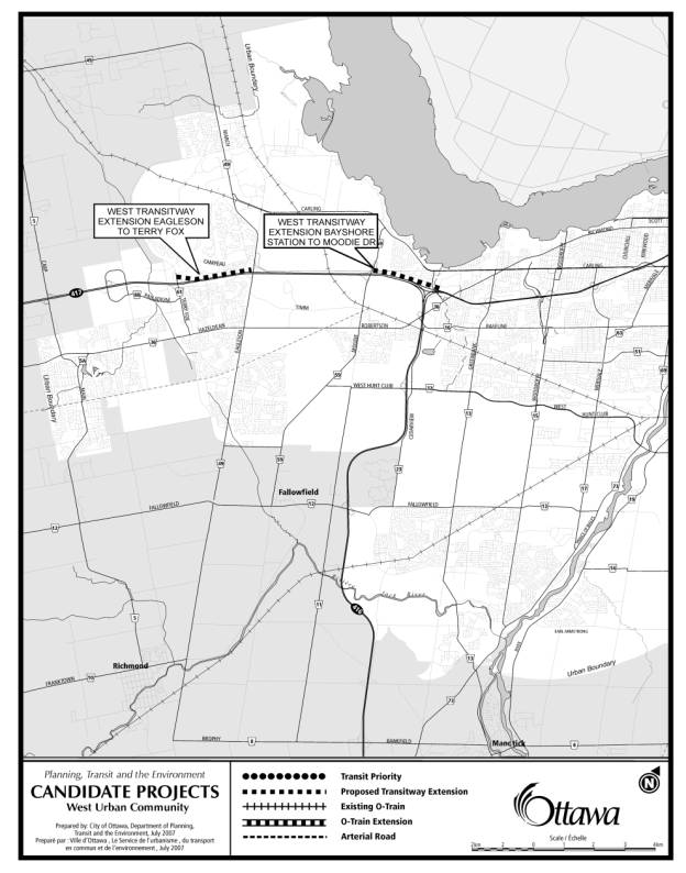
West Urban Community
These projects are shown in Document 3.
The 2.5-kilometre construction of the West Transitway Extension (Bayshore Station to Moodie Drive) would allow buses to avoid the highly congested portion of the Queensway between Moodie Drive and the Highway 416. West of Moodie Drive, the successful existing shoulder bus lanes will continue to be utilized. From Bayshore Station to Pinecrest, the West Transitway is already under construction.
At the 17 January 2007 meeting, Transit Committee deferred the implementation of the West Transitway Extension between Pinecrest and the Southwest Transitway until Council has determined the status of converting the Transitway to light rail transit. This decision will likely not occur until the TMP update is complete. Furthermore, since this project includes a cut-and-cover section near the connection to the Southwest Transitway, Transit Committee requested staff to investigate alternative cost-effective options for the corridor – this is the subject of a separate report.
The West Transitway Extension (Eagleson to Terry Fox) has funds to initiate design this year. The work is being coordinated with the Ministry of Transportation’s interchange planning at Eagleson/March Road and Highway 417, and the design to widen Highway 417 west of Eagleson/March Road.
The West Transitway corridor to Kanata was identified in the West Urban Community Transit Integration Study and Environmental Assessment in 1996. The first components of the corridor that have already been implemented are the Terry Fox Station and Park and Ride (completed in 2005), the Castlefrank/Kanata Partial Interchange that included a bridge over the future transit corridor, and the new Kanata Town Center Pedestrian Bridge.
This section of the West Transitway in the Kanata Town Center is planned to include three stations including the existing Terry Fox Station. The additional two stations are to be located at the Pedestrian Bridge and near Eagleson/March Interchange area to support and coordinate with planned development in the Kanata Town Center.
The Mayor’s Task Force had also recommended the completion of the West Transitway extensions as near-term projects. Completion of these projects will give transit users from Kanata a more reliable and faster connection to downtown. Expansion of the West Transitway would be complete between Pinecrest and Terry Fox – with the continuation of the highly successful shoulder bus lane operation between Moodie and Eagleson Drives.
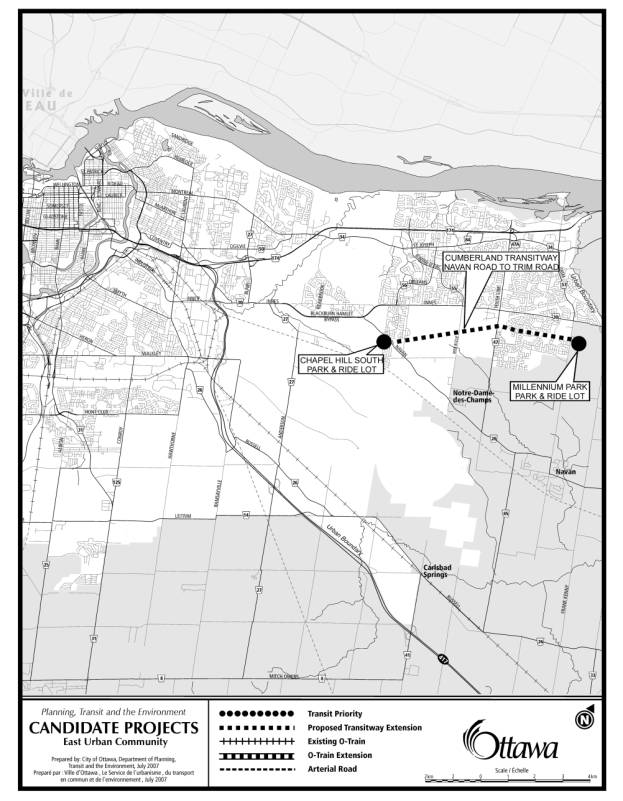
East Urban Community
These projects are shown in Document 4.
Construction of the Cumberland Transitway (Navan Road to Trim Road) is proposed, along with two Park and Ride lots at Chapel Hill South and Millennium Park. West of Navan Road, transit services would need to operate in mixed traffic along the Blackburn Hamlet Bypass, connect to Innes Road, and turn onto Blair Road to access the Blair Station and continue into downtown along the existing East Transitway. The Park and Ride lots will reduce the at-capacity problems at the Place d’Orleans lot and provide access to residents from the urban area, rural area, and beyond. Documentation and filing of the EA Addendum to address the extension of the Cumberland Transitway from Trim Road to Frank Kenny Road (to maximize integration of the future high school and Millennium Sports Park) is required. Soil conditions and drainage issues in the area may not allow grade separations to be built economically and therefore at-grade crossings with local streets will be reviewed, and EA documentation updated accordingly. Land would be required from the NCC and private landowners (Chapel Hill South Park and Ride lot).
The missing link of Transitway (Cumberland Transitway Westerly (from Navan Road to Blair Station)) still requires an environmental assessment. This section of Transitway could have been examined as part of the East-West LRT EA Study. Work did not proceed, however, due to the “on hold” status of the East-West LRT study. This issue is the subject of a separate report to respond to Committee’s motion that staff report back on environmental assessments that had been put on hold (ACS2007-PTE-POL-0048).
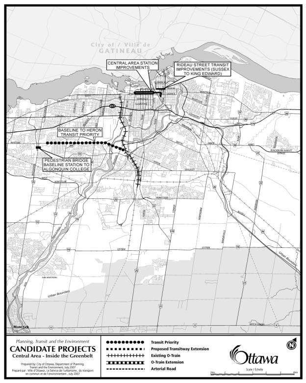
Central Area Community/Inside
the Greenbelt
These projects are shown in Document 5.
Central Area Station Improvements include relocation and physical improvements to bus platforms, improvements to enclosed waiting areas, and addition of an electronic real-time passenger information system, including completion of on-board bus location systems. Minor shifting of bus stop locations will help reduce congestion among buses and will reduce conflicts with other road uses. Reconstructed stops and improved waiting areas will improve conditions for customers waiting for buses. Electronic real-time passenger information will allow customers to queue in the correct location when the buses approach – this will result in reduced boarding time, which in turn increase the reliability of services and reduce average travel times. Improvements to downtown bus stops will be beneficial in the short term and the long term, as it is likely that any long-term plan for raid transit that may be developed and approved by Council would retain some bus operation on Albert, Slater, Rideau, Wellington, and Bank Streets. Some changes to these improvements may be required at particular locations depending on the details of the long-term plan for transit in the downtown.
The City is undertaking an urban design project to examine the issues of accommodating many different uses of Rideau Street between Sussex Drive and King Edward Avenue. One of the major uses of Rideau Street in this area is a main downtown access and transfer point for OC Transpo and STO transit services. In the longer term, the downtown transit strategy that is being developed for the TMP is intended to identify a way to accommodate many of the transit customers who now use this section of Rideau Street, but there will likely always be a need for frequent bus service on the street. Some of the recommendations of the urban design study will affect transit operations. These may include reconstructing the platforms and shelters, improving pedestrian conditions connecting to the transit platforms, and integrating the transit platforms and shelters with other land uses on the street. Funding arising from this report would be used toward the transit components of recommendations from the urban design project.
Baseline-Heron Transit Priority projects include five kilometres on Baseline Road (Navaho Drive to Prince of Wales) and three kilometres on Heron Road (Prince of Wales to Data Centre Road). Transit priority measures include sections of bus lanes (created by converting/sharing existing turning lanes or by constructing/extending new lanes), signal priority displays at intersections, queue jumps, infill of mid-block bus bays, bus stop relocations/consolidations and other modifications. The Baseline-Herron Transit Corridor Opportunities Study was completed in 2006. Functional planning is underway for the Heron Road section. Transit priority measures reduce transit travel times, resulting in operating and capital cost savings to the City. Reduced travel times and reliability of service (schedule adherence) have a direct positive impact on transit ridership and transit modal share.
At Baseline Station, a Pedestrian Bridge connecting to Algonquin College is recommended. It allows the high volume of transit users to safely cross Woodroffe Avenue from Baseline Station. It will reduce traffic delays to existing on-street transit services and enhance bus turning movements in and out of the station at the station entrances.
This pedestrian bridge was included in the EA study for the Southwest Transitway (Baseline to Strandherd), approved in 1997. Since 2002, the City has been in discussions with Algonquin College and has jointly developed a draft Memorandum of Understanding (MOU). It describes coordination for design, construction, and annual maintenance responsibilities. This MOU has to be updated and finalized when this project moves forward with implementation. The College’s Student Association strongly supports the pedestrian bridge and has allocated $300k from its own budget to ensure that modifications to the College’s Building B are well integrated with the bridge connection. The Nepean Centrepointe Development Plan Study currently underway for the lands west of Baseline Station identifies and supports the pedestrian bridge in conjunction with expanded transit services.
City-Wide/Others
General Transit Stop Improvements include the purchase and installation of new fully-accessible transit shelters, new paved waiting areas at bus stops, and new paved pedestrian links to bus stops. This includes minor works at bus stops to improve efficiency and ridership satisfaction (hard surface standing areas, eliminate risk of curb-side puddles, improve corner road radius for bus turning); approximately 170 new transit shelters to be installed at stops where the need is greatest; approximately 200 new paved waiting areas; and approximately 30 new pedestrian connections to transit stops. Transit Services Branch has completed an inventory of all bus stops on the transit system, identifying those where need for shelter is the greatest (using a combination of ridership, waiting time, degree of exposure to wind and precipitation, and the relative proportion of seniors and people with disabilities living in the area near the transit stop). Transit Services Branch will consult with Councillors and communities before finalizing the implementation plan.
Funding for the Smartcards is already in place and work is advancing. Council has provided direction to move to a smartcard fare system to increase transit ridership, reduce fare fraud and the ongoing cost of the fare system. Staff are currently working with the GTA smartcard project to determine whether it is in the City’s best interests to adopt the GTA fare system for Ottawa.
The City’s Official Plan, Transportation Master Plan, and Council-endorsed Rural Pathways Plan has identified several strategic linkages, providing pedestrian and cyclist connections to public transit. Transit-oriented Rural Pathway linkages such as an easterly extension of the Prescott-Russell trail through to the Navan and Notre-Dame-des-Champs Park and Ride lots and a southerly pathway connection from Osgoode Village through to Greely and Riverside South terminating at the Leitrim Park and Ride lot (and proposed O-Train station). These links will integrate with the existing pathway network, thereby encouraging rural residents to use public transit while providing an accessible recreational option for all residents.
A new bus garage is currently under construction on Industrial Road. This project provides bus maintenance and storage facilities along with support vehicles and equipment to accommodate growth in the transit fleet. Through the Fleet Service implementation of outdoor bus storage, the project has been changed in scope to incorporate outdoor storage and will be operational by 2009.
In June 2007, Council approved the Transit Fleet
Acquisition strategy through to 2012. Hybrid
diesel-electric buses remain the centrepiece of the mid-term component of
the City’s Fleet Emissions Reduction Strategy also approved by Council as a
means to “greening” the corporate fleet. Under the funding program parameters,
replacement buses are eligible project candidates and it is recommended that
the 2009 replacement bus order of 57 hybrid buses be included.
The following is a summary of the Task Force’s recommendations for immediate and short-term (by 2010) transportation projects and a brief outline of how these recommendations will be addressed. Some of the recommendations are included in the proposed list of near-term transportation investments and are indicated in the table below. The governance issue for Transit Services is the subject of a separate report, and as such is not noted in the summary. Transit operation issues are also not addressed because only infrastructure projects are being considered in this report.
Most of the projects identified by the Task Force require more in-depth analyses such as assessment of need, alternative options development and comparisons, ridership forecasting, environmental assessments, costing, benefit-cost analysis, etc. – and therefore are not as ready for implementation in the short term.
|
Task
Force Recommendations |
Remarks |
|
Immediate
(6-12 months): |
|
|
Adopt
recommendations in OC Transpo’s May 2007 report (Downtown Transit Operating
Strategies 2007-2010) to alleviate congestion in the downtown core |
Transit
Services is acting on the recommendations, based on funding availability. |
|
Protect
existing transit corridors for system development |
Transit
and transportation corridors are protected following confirmation of need for
such corridors (TMP network review) and completion of their respective EA
studies. The City has a policy to
acquire surplus railway Rights of Way and select utility corridors as they
become available for use as future transportation and utility corridors. |
|
Designate
and protect potential corridors for future development and especially protect
development over transit stations |
Corridor
protection is initiated upon confirmation of need (TMP network review) and
completion of EAs. |
|
Start/update
all EAs on proposed rail corridors |
TMP
update will identify appropriate rail corridors for LRT and EAs will be
initiated as appropriate. |
|
Reserve
land for rail corridors from the North-South line to downtown line across LeBreton
Flats |
TMP
update will identify appropriate rail corridors for LRT and EAs will be
initiated as appropriate. |
|
Protect
land to accommodate a rail extension to Cumberland |
TMP
update will revisit transit corridor requirements to serve Cumberland. |
|
Build
Terry Fox Road Extension |
Although
the EA has been completed for the entire corridor from Eagleson to March
Road, and sections have been built, the remaining section from Richardson
Side Road to March Road is a Phase 3 project in the TMP (widening from two to
four lanes). The first two lanes is
to provide access to new developments and the timing of their construction is
dependent on development needs. The TMP update will re-assess project
priorities to reflect growth projections and need. |
|
Start
EA for downtown tunnel |
TMP
update is developing a recommended downtown transit network in the context of
the overall transportation network which may include a transit tunnel. The downtown network will be presented to
Council in late Spring 2008 for approval.
The detailed EA work can be initiated shortly thereafter. |
|
Secure
safety ruling from Transport Canada for LRT track sharing with VIA and Ottawa
Central Railway (OCR) |
TMP
update will revisit the use of these tracks for public transit prior to
initiating discussions with Transport Canada. |
|
Begin
negotiations with VIA to share station infrastructure (Ottawa Station and
Fallowfield) |
Need
and justification for use of this corridor has to be determined before
initiating discussions – part of the TMP network review. |
|
Begin
negotiations with OCR to share tracks |
Need
and justification for use of this corridor has to be determined before
initiating discussions with OCR – part of the TMP network review. |
|
Start
discussions with Gatineau to extend rail service to the Casino |
The
City will be working with STO to develop an integrated interprovincial
transit solution and network. |
|
Extend
O-Train to Earl Armstrong Rd |
Extension
of the O-Train to Leitrim is proposed as a near-term transit investment. Extension beyond Leitrim would have to be
considered in the context of the overall network – part of the TMP review. |
|
Complete
roll out of Smartcards, support U-Pass |
Transit
Services is currently developing the Smartcard program. The smartcard will enable partnerships
with schools and post-secondary institutions to be pursued. |
|
Complete
design tendering for Strandherd-Armstrong Bridge |
Direction
to proceed with this project was approved by Council on 27 June 2007. Bridge is identified as feasible near-term
investment. Design will get underway
this year. |
|
Identify
sites for roundabouts to help calm traffic and reduce congestion |
Roundabouts
are already being considered as potential design options in both new
development and rehabilitation projects. Significant efforts are still required
in building public understanding and acceptance, particularly with the
possible use of multi-lane roundabouts at major intersections. |
|
Complete
cycling network strategy and development plan |
Public
Works and Services Department is completing this work and will present to
Committee by end of 2007. Higher-level strategic plan will be incorporated
into the TMP update. |
|
Short Term (by 2010): |
|
|
Build
Park and Ride at Leitrim |
Design
is already underway, with possible opening in 2009 or earlier. |
|
Build
Park and Ride at Earl
Armstrong (Assumption: site is directly south of the former CP
corridor) |
This
location was not included in the EA for the North-South LRT. Review of need and justification will be
part of the TMP review. |
|
Ellwood
Junction – modify to permit VIA and OCR lines to use the O-Train corridor |
Need
and justification for operating on VIA and OCR line will be assessed as part
of the TMP review |
|
Construct
new stations in VIA and OCR corridors |
Need
and justification for stations along these corridors will be assessed as part
of TMP review. |
|
Extend
West Transitway (as shown in OP) |
Extensions
of the West Transitway are proposed as near-term investments. |
|
Start
rush hour rail service from Kanata (March Road via OCR track) and Barrhaven
(Cedarview Road via VIA track) to Ottawa Station (VIA) |
Need
and justification for transit operation on these corridors will be assessed
as part of the TMP network review. |
|
Facilitate
services from Ottawa Station to Smith Falls, in partnership with Smith Falls |
In
accordance with Council’s direction of 27 June 2007, the City will petition
the Province to establish a commuter rail system to Smith Falls and other
areas beyond the City limits. |
|
Start
rush hour service from Kanata North and Barrhaven to Bayview |
Need
and justification for transit operation on these corridors will be assessed
as part of the TMP network review. |
|
Start
rush hour rail service on VIA track from Ottawa Station to rural
municipalities (partnership) |
The
TMP update will examine the feasibility of providing transit service
expansions to areas outside of the city’s urban transit area. As an interim measure, the City will
assist and support municipalities and other organizations proposing to
operate commuter bus services into Ottawa. |
|
Partner
with eastern and southern counties to increase uptake from commuter bus
and/or trains to railheads |
Staff
will continue to work with neighbouring municipalities and other
organizations to support commuter bus services and to integrate them with the
City’s transit system. |
|
Explore
opportunities to reopen the Prince of Wales Bridge for rail freight traffic |
The
TMP update will assess, at a strategic level, the appropriate use of the
Prince of Wales Bridge. |
|
Build
Strandherd-Armstrong Bridge and protect median for future transit use |
Direction
to proceed with this project was approved by Council on 27 June 2007. Bridge is identified as feasible near-term
investment. Construction will
immediately follow the completion and approval of the bridge design. |
|
Build
roundabouts to calm traffic and reduce congestion |
Roundabouts
are already being considered as potential design options in both new
development and rehabilitation projects. Significant efforts are still
required in building public understanding and acceptance, particularly with
the possible use of multi-lane roundabouts at major intersections. |
|
Implement
elements of the cycling plan as funding becomes available. |
The approved cycling
plan will be implemented based on available funds. |
Completed and approved environmental assessment studies have resolved the environmental issues. If new issues arise during design, they too will be appropriately addressed.
Rural residents will receive enhanced transit service through the expansion of the Transitway and the construction of new Park and Ride lots.
Transit-oriented Rural Pathways will provide pedestrian and cycling opportunities for rural residents to connect to existing pathway systems and transit stations.
The recommendations contained herein directly support the following Strategic Directions adopted by Council on 11 July 2007:
No public consultation was undertaken for the preparation of this report.
There are no financial implications as a result of the
approval of this report. Following
negotiations with the Federal and Provincial agencies, staff will report back
to Committee on the availability of funding mechanisms and the full financial
implications of these projects with respect to development charges and tax
supported reserves.
Document
1 Candidate Projects – City Wide Overview
Document
2 Candidate Projects – South Urban
Community
Document
3 Candidate Projects – West Urban
Community
Document
4 Candidate Projects – East Urban
Community
Document
5 Candidate Projects – Central Area –
Inside the Greenbelt
Planning, Transit and the Environment Department will contact the upper-tier government agencies to discuss funding commitments. Where Council has already approved funding, the work on those projects will continue.
CANDIDATE PROJECTS – CITY WIDE OVERVIEW DOCUMENT 1
CANDIDATE PROJECTS – SOUTH URBAN COMMUNITY DOCUMENT 2
CANDIDATE PROJECTS – WEST URBAN
COMMUNITY DOCUMENT
3
CANDIDATE PROJECTS – EAST URBAN
COMMUNITY DOCUMENT
4
CANDIDATE PROJECTS – CENTRAL
AREA-INSIDE
THE GREENBELT DOCUMENT 5