|
4. ZONING - 5649 AND 5705 HAZELDEAN ROAD ZONAGE - 5649 ET 5705, CHEMIN HAZELDEAN |
Committee recommendation
(This
application is not subject to Bill 51)
That Council approve an amendment
to the former Township of Goulbourn Zoning By-law No. 40-99 to change the
zoning of 5649 and 5705 Hazeldean Road from "A1" Agriculture),
"A1‑2" (Agriculture, Exception 2) and "EPA"
(Environmental Protection Area) to "CLR1-1", "CLR1-2" and
"CLR1-3" (Community Level Retail 1, Exception 1, 2 and 3),
"D" (Future Development), and "NEA-1" (Natural Environment
Area, Exception 1) as shown in Document 1 and detailed in Document 6.
Recommandation du Comité
(Cette demande n’est
pas assujettie au Règlement 51)
Que le Conseil approuve une modification
au Règlement de zonage no 40-99 de l’ancien Canton de Goulbourn afin de changer
la désignation de zonage des 5649 et 5705, chemin Hazeldean de « A1 » (zone
agricole), « A1-2 » (zone agricole assortie d’une exception 2) et « EPA »
(secteur de protection de l’environnement) à « CLR1-1 », CLR1-2 » et « CLR1-3 »
(zones de commerce de détail dans la communauté 1, assorties des exceptions 1,
2 et 3), « D » (zone d’aménagement futur) et « NEA-1 » (secteur d’environnement
naturel assorti d’une exception 1), tel qu’il est indiqué dans le document 1 et
expliqué en détail dans le document 6.
Documentation
1.
Deputy
City Manager's report Planning, Transit
and the Environment dated
27 July 2007 (ACS2007-PTE-APR-0059).
2. Extract of Draft Minutes, 28 August
2007
Report to/Rapport au :
Planning and Environment Committee
Comité de l'urbanisme et de l'environnement
and Council / et au Conseil
July 27, 2007 / le 27 juillet 2007
Submitted by/Soumis par : Nancy Schepers, Deputy City Manager /
Directrice municipale adjointe,
Planning, Transit and the Environment /
Urbanisme, Transport en commun et Environnement
Contact
Person/Personne Ressource : Grant Lindsay, Manager / Gestionnaire,
Development Approvals / Approbation des demandes d'aménagement
(613)
580-2424, 13242 Grant.Lindsay@ottawa.ca
|
SUBJECT: |
ZONING - 5649 and 5705 Hazeldean Road (FILE
NO. D02-02-05-0144) |
|
|
|
|
OBJET : |
REPORT RECOMMENDATION
That the Planning and Environment
Committee recommend Council approve an amendment to the former Township of
Goulbourn Zoning By-law No. 40-99 to change the zoning of 5649 and 5705
Hazeldean Road from "A1" Agriculture), "A1‑2"
(Agriculture, Exception 2) and "EPA" (Environmental Protection Area)
to "CLR1-1", "CLR1-2" and "CLR1-3" (Community
Level Retail 1, Exception 1, 2 and 3), "D" (Future Development),
and "NEA-1" (Natural Environment Area, Exception 1) as shown in
Document 1 and detailed in Document 6.
RECOMMANDATION DU RAPPORT
Que le Comité de l'urbanisme et de l'environnement
recommande au Conseil d’approuver une modification au Règlement de zonage no
40-99 de l’ancien Canton de Goulbourn afin de changer la désignation de zonage
des 5649 et 5705, chemin Hazeldean de « A1 » (zone agricole), « A1-2 » (zone
agricole assortie d’une exception 2) et « EPA » (secteur de protection de
l’environnement) à « CLR1-1 », CLR1-2 » et « CLR1-3 » (zones de commerce de
détail dans la communauté 1, assorties des exceptions 1, 2 et 3), « D » (zone
d’aménagement futur) et « NEA-1 » (secteur d’environnement naturel assorti
d’une exception 1), tel qu’il est indiqué dans le document 1 et expliqué en
détail dans le document 6.
EXECUTIVE SUMMARY
Assumptions and Analysis:
The subject property is located at
the northeast and northwest corners of the Hazeldean Road and Huntmar
Drive/Iber Road intersection within the Kanata West planning area, as shown in
Document 1. The site has an area
of 18.2 hectares and is vacant farmland that is no longer under agricultural
production. A small portion of the site has been used for a seasonal
landscaping business. Poole Creek is
located in the northeast corner of the property, and Hazeldean Tributary
crosses the southeast corner adjacent to Hazeldean Road. The site is bisected by the Huntmar Drive
extension, which is currently being constructed from Maple Grove Road to the
intersection of Hazeldean Road and Iber Road.
The site
is subject to a subdivision application to create four commercial development blocks adjacent to
Hazeldean Road and Huntmar Drive, one residential development block to the
north of the commercial blocks, a public street at the eastern edge of the site
for a future North-South Arterial Road, and four blocks for a widening along
Hazeldean Road.
The recommendation is to approve amendments to
the former Township of Goulbourn Zoning By-law to: 1) rezone the commercial
blocks within the subdivision from “A1” (Agriculture) and “A1-2” (Agriculture,
Exception 2) zones to new, site-specific “CLR1-1”, “CLR1-2”, and “CLR1-3”
(Community Level Retail 1, Exception 1, 2 and 3) zones; 2) rezone the
residential block from an “A1-2” zone to a “D” (Future Development) zone; 3)
rezone the Poole Creek corridor from “A1”, “A1-2” and “EPA” (Environmental
Protection Area) zones to an “NEA-1” (Natural Environment Area, Exception 1)
zone; and 4) rezone a corridor for the relocation of Hazeldean Tributary
corridor from an “A1-2” zone to an “NEA-1” zone.
The subject property is designated as “Arterial Mainstreet”, “General Urban Area” and “Major Open Space” in the Official Plan and as “Community Level Retail”, “Residential Area B” and “Creek Corridor” in the Kanata West Concept Plan. The Department recommends rezoning the four commercial development blocks to site-specific “CLR1” (Community Level Retail 1) exception zones. The proposed zoning complies with the land use designations in the Official Plan and the Kanata West Concept Plan, and is consistent with the Urban Design Guidelines for the Community Level Retail district and for development along Arterial Mainstreets. The recommended Zoning By-law amendment will allow for the development of the commercial blocks with a shopping centre containing approximately 26500 square metres of retail and service commercial space, including an automotive service centre and car wash at the northwest corner of Hazeldean Road and Huntmar Drive. In addition, the proposed zoning will permit the future intensification of the commercial blocks with a broad range of uses including offices and apartment buildings to facilitate the development of a compact, mixed-use node within walking distance of the future rapid transit station planned to the east of the property.
The residential block will be
rezoned to a “D” (Future Development) zone, and will require a future rezoning
after a detailed subdivision application has been submitted for the block. The Poole Creek and relocated Hazeldean
Tributary corridors will be rezoned to an “NEA-1” (Natural Environment Area,
Exception 1) zone to restrict the permitted uses to conservation and passive
park uses only.
Financial Implications:
No costs are anticipated to be incurred by the City.
Public Consultation/Input:
A
public open house was held for the subject application and the concurrent
subdivision application on February 2, 2006.
Comments from the public included the following: who pays for the
extension of Huntmar Drive, the construction of the transit corridor, and the
widening of Hazeldean Road; the timeline for development; similarities to
Kanata Centrum; access from Hazeldean Road; and the potential for mixed-use
development and improved livability.
RÉSUMÉ
Hypothèses et analyse :
La propriété visée se trouve aux angles
nord-est et nord-ouest du chemin Hazeldean et au carrefour entre la promenade
Huntmar et le chemin Iber, dans la zone d’aménagement de Kanata-Ouest, tel
qu’illustré dans le document 1. L’emplacement, une terre agricole inoccupée et inexploitée sur le plan agricole,
totalise une superficie de 18,2
hectares. Une petite partie de l’emplacement a été utilisée par une entreprise
saisonnière d’aménagement paysager. Le ruisseau Poole coule à l’angle nord-est
de la propriété et l’affluent Hazeldean traverse l’angle sud-est, le long du
chemin Hazeldean. L’emplacement est divisé en deux parties par le prolongement
de la promenade Huntmar, en cours d’aménagement entre le chemin Maple Grove et
l’angle des chemins Hazeldean et Iber.
Le terrain fait l’objet d’une demande de
lotissement en vue de la création de quatre îlots commerciaux donnant sur le
chemin Hazeldean et la promenade Huntmar, d’un îlot résidentiel au nord des
îlots commerciaux, d’une voie publique sur la façade est du terrain, qui
deviendra une artère nord-sud, et de quatre îlots pour un élargissement le long
du chemin Hazeldean.
La recommandation vise à approuver les modifications suivantes au règlement
de zonage de l’ancien canton de Goulbourn : 1) attribuer un nouveau zonage
aux îlots commerciaux du lotissement, en les faisant passer de zones
« A1 » (Agriculture) et « A1-2 » (Agriculture, exception 2)
à de nouvelles zones propres aux emplacements « CLR1-1 »,
« CLR1-2 » et « CLR1-3 » (commerce de détail de quartier 1,
exceptions 1, 2 et 3); 2) attribuer un nouveau zonage à l’îlot résidentiel, en
le faisant passer de zone « A1-2 » à zone « D »
(aménagement futur); 3) attribuer un nouveau zonage au couloir du ruisseau
Poole, en le faisant passer de zones « A1 », « A1-2 » et
« EPA » (zone de protection environnementale) à zone
« NEA-1 » (zone écologique naturelle, exception 1); et 4) attribuer
un nouveau zonage au couloir de l’affluent Hazeldean, en vue de son
déplacement, en le faisant passer de « A1-2 » à zone
« NEA-1 ».
La propriété visée est désignée « artère principale »,
« zone urbaine générale » et « espace ouvert principal »
dans le Plan officiel, et « commerce de détail de quartier »,
« secteur résidentiel B » et « couloir de ruisseau » dans
le Plan conceptuel de Kanata-Ouest. Le Service recommande la modification du
zonage des quatre îlots d’aménagement commercial en zones d’exception
« CLR1 » propres à l’emplacement (commerce de détail de quartier 1).
Le zonage proposé est conforme aux désignations d’utilisation du sol du
Plan officiel et du Plan conceptuel de Kanata-Ouest, et correspond aux lignes
directrices de conception urbaine du secteur de commerce de détail de quartier
et à celles d’aménagement sur des artères principales. La modification
recommandée au règlement de zonage permettra l’aménagement des îlots
commerciaux et notamment d’un centre commercial constitué d’environ 26 500
mètres carrés d’espace de commerce de détail et de services, y compris un
centre de service automobile et un lave-auto à l’angle nord-ouest du chemin
Hazeldean et de la promenade Huntmar. De plus, le zonage proposé permettra la
densification éventuelle des îlots commerciaux grâce à une vaste gamme
d’utilisations, comme des édifices à bureaux et des immeubles d’appartements,
ce qui facilitera l’aménagement d’un centre polyvalent compact à distance de
marche de la future station de transport en commun rapide, dont la construction
est prévue à l’est de la propriété.
L’îlot résidentiel, qui verra son zonage
être modifié en zone « D » (aménagement futur), devra faire l’objet
d’un nouveau zonage après qu’une demande détaillée de lotissement aura été
présentée pour l’îlot. Le zonage des couloirs du ruisseau Poole et de
l’affluent Hazeldean déplacé sera modifié en zone « NEA-1 » (zone
écologique naturelle, exception 1) afin de limiter les utilisations autorisées
aux parcs de conservation et passifs uniquement.
Répercussions financières :
La Ville ne devrait engager aucuns frais.
Consultation publique / commentaires :
Une réunion publique a été tenue le 2 février 2006
au sujet de la demande susmentionnée et de la demande de lotissement qui s'y
rapporte. Les commentaires émis par le public concernaient notamment le
paiement du prolongement de la promenade Huntmar, de la construction du couloir
de transport en commun et de l'élargissement du chemin Hazeldean ainsi que le
calendrier des travaux d'aménagement, les similitudes avec le Centrum de
Kanata, l'accès depuis le chemin Hazeldean et la possibilité d'aménagements
polyvalents et d'amélioration de l'habitabilité.
BACKGROUND
Site Context
The subject property is located at the northeast and northwest corners
of the Hazeldean Road and Huntmar Drive/Iber Road intersection within the
Kanata West planning area, as shown in Document 1. The site has an area of 18.2 hectares and is
vacant farmland that is no longer under agricultural production. A small
portion of the site has been used for a seasonal landscaping business. Poole Creek is located in the northeast
corner of the property, and Hazeldean Tributary crosses the southeast corner
adjacent to Hazeldean Road. The site is
bisected by the Huntmar Drive extension, which is currently being constructed
from Maple Grove Road to the intersection of Hazeldean Road and Iber Road.
To the
north of the property is a registered residential subdivision that is under
development with a total of approximately 850 dwelling units. To the east of the site and immediately north
of Hazeldean Road is a 17-hectare site that is subject to subdivision and
Zoning By-law amendment applications to permit a shopping centre with a gross
floor area of 37000
square metres, and a rapid
transit corridor and station. Also to
the east of the site and north of this proposed shopping centre is a 46-hectare
site that is subject to subdivision and Zoning By-law amendment applications to
permit a residential subdivision with 1200 to 1400 dwelling units. The following uses are located south of Hazeldean
Road opposite the site: the Iber Road Industrial Park; a proposed automotive
service centre and car wash at the southwest corner of Iber Road and Hazeldean
Road; two single detached dwellings; and vacant agricultural land that is
included in the planning area for the Fernbank Community Design Plan. The property to the west is vacant land
owned by the City.
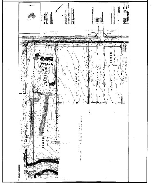
Concurrent Application
A
subdivision application is being processed concurrently with the subject Zoning
By-law amendment application. The purpose
of the subdivision application is to create the following:
·
four
commercial development blocks adjacent to Hazeldean Road and Huntmar Drive;
·
one
residential development block to the north of the commercial blocks;
·
a
public street at the eastern edge of the site for a future North-South Arterial
Road;
·
four
blocks for a widening along Hazeldean Road.
A future subdivision application will be
required to further subdivide the residential block.
The draft plan of subdivision is shown in Document 2. The application is pending draft plan approval.
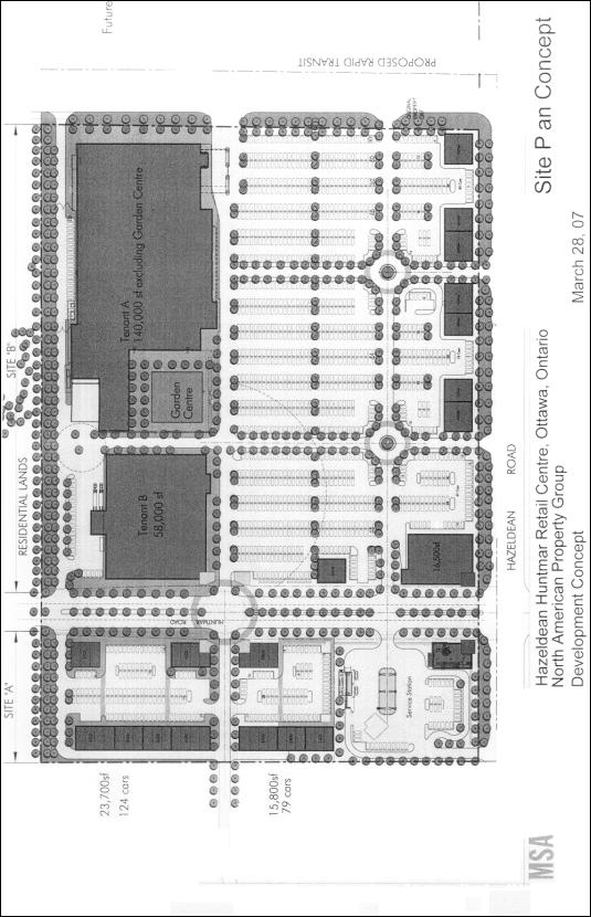
Development Proposal
The applicant plans to develop the commercial
blocks with a shopping centre containing approximately 26500 square metres of
retail and service commercial space.
Potential anchor tenants include a supermarket and a home improvement
store. An overall concept plan for the
commercial development blocks is included in Document 3. The development plans for the residential
block have not yet been established.
Vehicular access to the shopping centre will be
provided from three arterial roads - Hazeldean Road, Huntmar Drive and the
future North-South Arterial. Hazeldean
Road, which currently has a two-lane rural cross-section, is planned to be
widened to a four-lane divided cross-section between Carp Road and Terry Fox
Drive. A construction start date has
not been confirmed for this project, but construction is anticipated to
commence between 2011 and 2016. Huntmar
Drive is currently being constructed with a four-lane, divided cross-section between
Hazeldean Road and Maple Grove Road, and is expected to be opened in 2007. The future North-South Arterial is proposed
to have a four-lane divided cross-section, and will have a signalized
intersection at Hazeldean Road. Class
environmental assessments have been completed for all three arterial
roads. The North-South Arterial road
project is subject to a request to the Minister of the Environment for the
proponent to comply with Part II of the Environmental
Assessment Act.
Access to the shopping centre is proposed from
right-in, right-out driveways on Hazeldean Road, and driveways on Huntmar Drive
and the future North-South Arterial. It
is intended that the site will have signalized access from Huntmar Drive and
the North-South Arterial. The location
and design of the driveways, and potential intersection modifications will be
addressed later through the site plan approval process and the roadway
modification approval process.
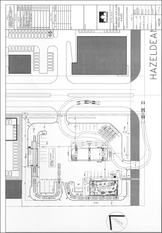
The commercial block at the northwest corner of
the Hazeldean Road and Huntmar Drive intersection is to be developed with an
automotive service centre. This
development will contain a convenience store with a sit-down eating area, and a
car wash. Access will be provided by
one driveway on Hazeldean Road and one driveway on Huntmar Drive. A conceptual site plan of the automotive
service centre is shown in Document 4, and elevations of the proposed
convenience store are contained in Document 5.
Hazeldean Tributary is located on lands that
are to be conveyed to the City for the future North-South Arterial and the
Hazeldean Road widening through the subdivision process. The segment of the tributary between
Hazeldean Road and the Carp River is proposed to be relocated to a naturalized,
open channel corridor, with the exception of crossings of three public roads
and a temporary drive aisle. The
Hazeldean Tributary relocation is being coordinated with the residential and
commercial subdivision applications for the lands located immediately east of
the site. The Hazeldean road widening
project includes the construction of a new box culvert for the Hazeldean
Tributary crossing and a further realignment of the watercourse between
Hazeldean Road and the North-South Arterial.
Existing Zoning
5705 Hazeldean Road is currently zoned “A1” (Agriculture) in the former Township of Goulbourn Zoning By-law No. 40-99. This zone permits a range of residential and non-residential uses including, but not limited to a single detached dwelling, a group home, a bed and breakfast establishment, a farm, a forestry use, a kennel and a riding horse establishment.
5649 Hazeldean Road is zoned “A1”, “A1-2” (Agriculture, Exception 2) and “EPA” (Environmental Protection Area). The “A1-2” zone permits a garden centre in addition to the uses permitted in the “A1” zone. The “EPA” zone applies to part of the Poole Creek corridor and permits a conservation use, a farm, a forestry use, a golf course, a passive park, a parking lot and a public use.
Proposed Zoning
The applicant has applied to rezone
the commercial development blocks to new, site-specific “CLR1” (Community Level
Retail 1) zones and to rezone the residential block to a “D” (Future
Development) zone. The Department is also
recommending that the Poole Creek and relocated Hazeldean Tributary corridors
be rezoned to an “NEA-1” (Natural Environment Area, Exception 1)
zone.
The requested “CLR1” zoning for the
commercial blocks would permit a full range of retail, personal service,
office, restaurant and automotive uses, including establishments with
drive-through facilities, as well as higher-density residential uses.
The “D” zone requested for the
residential block permits existing residential or non-residential uses. This zone recognizes that a further Zoning
By-law amendment would be necessary after a detailed subdivision application
has been submitted for this block.
The proposed “NEA-1” zone for the
Poole Creek and relocated Hazeldean Tributary corridors permits a conservation
use and a passive park. The range of
uses permitted in the “NEA-1” zone is narrower than the existing “EPA” zone,
which applies to part of the Poole Creek corridor, and better reflects the
intended use of the corridors. The
proposed “NEA-1” zoning for the Poole Creek corridor is also consistent with a
recent Zoning By-law amendment for the residential subdivision to the north of
the site.
DISCUSSION
Official Plan
Kanata West Concept Plan
The subject land is located within
Kanata West, which is identified in Annex 5 of the Official Plan as an area
subject to a Community Design Plan or Policy Plan approved by City
Council. Kanata West includes about 725
hectares of lands and is generally located north and south of Highway 417 in
the vicinity of the Palladium Drive interchange and the Huntmar Drive
overpass. Hazeldean Road forms the
southern boundary of Kanata West.
Council approved the Kanata West
Concept Plan in 2003. According to the
Concept Plan, Kanata West is intended to be a sustainable community in terms of
the mix of uses and the form of development and will provide a full complement
of opportunities for people to live, work, play and learn. The Concept Plan provides for the
accommodation of approximately 25000 jobs, 5000 residential units and
supporting retail all within a framework of natural corridors and
waterways. The mix of uses will include
office, residential, retail, institutional, entertainment and leisure uses.
Commercial Development Blocks
The Official Plan designates
Hazeldean Road from Huntmar Drive/Iber Road to Eagleson Road as an “Arterial
Mainstreet”, which includes two of the four commercial development blocks. Huntmar Drive forms the western boundary of
the Arterial Mainstreet designation, and the two commercial blocks on the west
side of Huntmar Drive are technically designated as “General Urban Area”. Given that the blocks on the west side of
Huntmar Drive are located immediately adjacent to the Arterial Mainstreet
designation and form part of the same shopping centre development, staff believe
that it would be appropriate to integrate these blocks as part of the Arterial
Mainstreet corridor to achieve a consistent and co-ordinated development
form. Accordingly, the proposed
development within all four commercial development blocks was reviewed in the
context of the Arterial Mainstreet policies.
The Arterial Mainstreet designation
identifies areas that are planned to provide a mix of uses and have the
potential to evolve, over time, into more compact, pedestrian-oriented and
transit-friendly places. A broad range
of uses is permitted including retail and service commercial uses, offices,
residential, and institutional uses.
Uses may be mixed in individual buildings or occur side by side in
separate buildings.
In 2006, Council approved Urban
Design Guidelines for development along Arterial Mainstreets. The objectives of the guidelines include
promoting a comfortable pedestrian environment; creating attractive
streetscapes; achieving a high-quality built form; establishing a strong street
edge; facilitating a gradual transition to more intensive forms of development;
accommodating a broad range of uses; and enhancing connections to public
transit, roads and pedestrian walkways.
Hazeldean Road, Huntmar Drive and the future
North-South Arterial are designated as Arterial Roads in the Official
Plan. Immediately to the east of the
site is a “Future Rapid Transit Corridor (Alignment to be Defined)” that will
extend from Kanata Centrum to Scotiabank Place and then to Hazeldean Road. The Transportation Master Plan identifies a
“Future Potential Transit Station” at the northeast corner of Hazeldean Road
and the North-South Arterial.
The Kanata West Concept Plan
designates the north side of Hazeldean Road from the Carp River to Fringewood
Drive as “Community Level Retail”. This
corridor has a length of approximately 1.4 kilometres, and includes all four
commercial blocks within the subdivision, the City lands to the west, and the
proposed shopping centre site to the east.
The Community Level Retail designation permits a broad mix of uses
including personal and community-serving uses, leisure and entertainment uses,
retail and commercial uses, institutional uses, residential uses, hotels, and
bed and breakfast establishments. The
Kanata West Concept Plan also contains urban design guidelines for the
Community Level Retail district that address issues such as the block pattern,
parks and open space, the streetscape treatment, and building siting and
massing.
The applicant has submitted an urban
design brief demonstrating how the site can be developed in accordance with the
Arterial Mainstreet and Community Level Retail Urban Design Guidelines. The urban design brief includes a set of
urban design principles, a development concept (shown in Document 3), and a
future infill concept plan demonstrating how the site can be intensified in the
future. The urban design features being
considered for the shopping centre include a pedestrian terrace at a future signalized
intersection on Huntmar Drive; individual storefronts along Hazeldean Road and
Huntmar Drive; a Stittsville Village building character for many of the
buildings along Hazeldean Road; a gateway building at the Hazeldean
Road/Huntmar Drive intersection; trellis structures to define the street edge
adjacent to parking areas; two round-a-bouts within the parking area;
pedestrian gateways; and landscaped pedestrian walkways.
The proposed retail and service
commercial uses comply with the intent of the Arterial Mainstreet and Community
Level Retail designations. The
applicant is also requesting zoning to permit office and residential uses,
which are also permitted by these designations. Further, the urban design brief supports the development of the
proposed shopping centre in keeping with the Arterial Mainstreet and Community
Level Retail Urban Design Guidelines.
The implementation of the Urban Design Guidelines will be addressed
through the proposed zoning provisions, the conditions of draft plan approval
for the concurrent subdivision application, and the site plan approval process
for each development phase.
Compatibility with the residential
uses proposed immediately north of the site will be achieved through the zoning
provisions and the site plan approval process.
Zoning provisions that will mitigate the impact of the development
include a requirement for a minimum 10-metre wide landscape buffer adjacent to
a residential zone, and a reduction in the maximum building height within 20
metres of a residential zone.
The applicant submitted a Community
Transportation Study in support of the zoning for the proposed shopping centre
development. A more detailed
Transportation Impact Study will be required through the site plan approval
process to address the location and design of the proposed accesses, signalized
intersections and roadway modifications.
The Kanata West Concept Plan
requires the submission of a retail market study for a Zoning By-law amendment
application in the Community Level Retail designation. The market study submitted with the
application demonstrates that there will be ample growth to support the
proposed shopping centre and other currently designated developments in Kanata
and Stittsville. As such, there is no risk that the proposed development would
in any way undermine the commercial potential from either the Kanata Town
Centre or Main Street Stittsville. The
market study has been reviewed and accepted by the Department.
Automotive Service Centre
The applicant is proposing to
develop the commercial block at the northwest corner of Hazeldean Road and
Huntmar Drive with an automotive service centre including a convenience store,
a car wash and associated drive-through queues. These uses are specifically permitted under the Arterial
Mainstreet policies. The site is an
appropriate location for an automotive service centre. It is located at the intersection of two
arterial roads to conveniently serve the broader traveling public, and is
situated away from any established residential neighbourhoods.
The automotive service centre is
compatible with the proposed shopping centre uses to the north and east; with
the proposed automotive service centre to the south; and with the vacant lands
to the west, which are also designated “Community Level Retail”. The only existing residential use near the
site is a single detached dwelling at 5734 Hazeldean Road, which is located
southwest of the site across Hazeldean Road.
This dwelling is situated approximately 49 metres south of Hazeldean
Road, and is 100 metres from the proposed convenience store building. The proposed car wash building will be
located north of the convenience store building, and further away from the
dwelling. The proposed development is
not expected to significantly impact the residence due to the separation of the
uses by Hazeldean Road and by distance.
The automotive service centre is proposed at
a major arterial road intersection and at the main entry point into Kanata West
from Hazeldean Road. The applicant is
proposing an upgraded architectural treatment for the convenience store
building, shown in Document 5, to reflect this important site context. The building design will also be compatible
and complementary to the proposed shopping centre development on the remaining
commercial development blocks.
The applicant has demonstrated through the
conceptual site plan and elevations that the automotive service centre can be
developed in keeping with the general intent of the design objectives and
principles in the Official Plan and the Council-approved Urban Design
Guidelines for development along Arterial Mainstreets, for Gas Stations and for
Drive-Through Facilities. The
implementation details will be addressed through the site plan approval
process.
The Arterial Mainstreet and Community Level
Retail Urban Design Guidelines support locating buildings close to the
street. A maximum 11-metre setback is
proposed from Hazeldean Road to the convenience store building. This location balances the intent of the
guidelines with the functional requirements for the development. These include providing adequate attendant
surveillance of the refueling area from the convenience store, and
accommodating a drive-through queue around the convenience store.
Residential Development Block
The residential development block is
designated as “General Urban Area” in the Official Plan, which permits all
types and densities of housing, as well as employment, shopping, service,
industrial, cultural, leisure, park and natural areas, entertainment and
institutional uses. The Kanata West
Concept Plan designates the residential block as “Residential Area B”, which
permits residential uses, personal and community-serving uses, institutional
uses, small business opportunities and apartments up to four-storeys in height.
Poole Creek Corridor
The
Poole Creek corridor is designated as “Major Open Space” in the Official
Plan. The intent of this designation is
to protect the larger open spaces in Ottawa that are in or are intended to be
in public ownership and are to be generally available for public use and
enjoyment. The owner will be required
to convey the corridor to the City through the concurrent subdivision
application. A pathway system and local
restoration works are proposed for the corridor by the Carp River, Poole Creek
and Feedmill Creek Restoration Class Environmental Assessment, which is
currently subject to several requests for Part II Orders under the Environmental Assessment Act. Poole Creek is identified as a “Creek Corridor” in the Kanata West Concept
Plan.
Hazeldean Tributary Corridor
Hazeldean Tributary is designated as
part of the Hazeldean Road Arterial Mainstreet designation in the Official
Plan. In the Kanata West Concept Plan,
the relocated Hazeldean Tributary corridor to the east of the site is
designated as a Creek Corridor between the future rapid transit station and the
Carp River.
Details of Recommended Zoning
The proposed amendment will rezone
the commercial blocks in the subdivision from “A1” (Agriculture) and “A1-2”
(Agriculture, Exception 2) zones to new, site-specific “CLR1-1”, “CLR1-2”, and
“CLR1-3” (Community Level Retail 1, Exception 1, 2 and 3) zones. The amendment will also rezone the
residential block from an “A1-2” zone to a “D” (Future Development) zone; the
Poole Creek corridor from “A1”, “A1-2” and “EPA” (Environmental Protection
Area) zones to an “NEA-1” (Natural Environment Area, Exception 1) zone; and the
relocated Hazeldean Tributary corridor from an “A1-2” zone to an “NEA-1” zone. The boundaries of the proposed zones are
identified in Document 1. The details
of the proposed zoning are contained in Document 6 and summarized below.
Community Level Retail 1 Zone
The proposed zoning will add a new “CLR1” (Community Level Retail 1) zone to the former Township of Goulbourn Zoning By-law that will permit a broad mix of uses in keeping with the range of uses set out in the Arterial Mainstreet and Community Level Retail policies. The permitted uses will include apartments and a large range of non-residential uses including, but not limited to a shopping centre, retail stores, restaurants, banks, offices, clinics, recreational establishments, automotive parts and accessories stores, and garden centres. Automotive service centres and car wash uses will not be permitted in the parent “CLR1” zone. The proposed automotive service centre and car wash at the northwest corner of Hazeldean Road and Huntmar Drive will be permitted through a site-specific exception to the “CLR1” zone provisions.
To facilitate the evolution of
Arterial Mainstreets into more compact, pedestrian-oriented and transit
friendly places, the Official Plan indicates that the Zoning By-law may define
the portion of the street frontage of an Arterial Mainstreet to be occupied by
buildings located at or set back minimally from the sidewalk. In this regard, the Urban Design Guidelines for development along
Arterial Mainstreets state that new buildings should be set zero to three
metres back from the front property line and zero to three metres back from the
side property line for corner sites, in order to define the street edge and
provide space for pedestrian activities and landscaping. Similarly, the Urban Design Guidelines for the Community
Level Retail district indicate that stand-alone buildings should be located
close to front or side lot lines and should not be interrupted with
drive-through lanes. The proposed “CLR1” zone specifies that for larger
lots with over 90 metres of frontage a minimum of 30 per cent of the lot
frontage shall be occupied by buildings within three metres of the front lot
line adjacent to Hazeldean Road. A maximum setback of three metres is
also proposed for buildings located within 50 metres of Huntmar Drive and the
future North-South Arterial. An
exception is proposed to accommodate commercial patios or outdoor amenity areas
between the building and street line, where the maximum building setback is
increased to six metres from the street line.
The Official Plan supports building heights of up to eight storeys on Arterial Mainstreets, with taller building heights being considered near transit stations. The Urban Design Guidelines for the Community Level Retail district generally contemplate lower building heights of up to four storeys, but with taller buildings permitted in proximity to the future transit station.
The proposed “CLR1” zone will permit a maximum building height of 15 metres (approximately four storeys) in keeping with the latter design guidelines. A reduced building height of 11 metres is proposed within 20 metres of a residential zone.
Site-specific provisions are proposed in the “CLR1-3” zone to allow building heights of up to 35 metres (approximately 10 storeys), on the blocks that are located near the future Hazeldean Road transit station.
A minimum parking ratio of 3.4 spaces per 100 squares of gross floor area is proposed for a shopping centre use. This ratio is based on the parking requirements in the Draft Comprehensive Zoning By-law.
The proposed zoning requires a minimum
three-metre wide landscape strip between a parking area or drive aisle and a
street line. A minimum 2.5-metre
landscape strip is required between a parking area or drive aisle and a side
lot line or a rear lot line. These
provisions are drawn from the Urban Design Guidelines for Development along
Arterial Mainstreets.
It is noted that the permitted uses and
provisions of the proposed “CLR1” zone are identical to a “CLR” zone that is
proposed to be introduced through a Zoning By-law amendment application at 613,
5585 and 5601 Hazeldean Road, which will be considered by Council on August 29,
2007. A separate “CLR1” is proposed to
allow the zoning application for 5649 and 5705 Hazeldean Road to proceed
independently of the zoning for 613, 5585 and 5601 Hazeldean Road. This is intended to avoid a potential
scenario where an appeal to the Zoning By-law for 613, 5585 and 5601 Hazeldean
Road could prevent the zoning for 5649 and 5705 Hazeldean Road from coming into
force.
Community Level Retail 1 Zone, Exception 1
Area “A”, shown on the Location Map in Document 1, is proposed to be zoned “CLR1-1”. Special provisions are proposed to recognize that Area “A” has frontage on Huntmar Drive rather than Hazeldean Road. The special provisions include the definition of the front lot line, and the establishment of a minimum 10-metre interior side yard adjacent to a residential zone.
Community Level Retail 1 Zone, Exception 2
Site-specific provisions are recommended to allow an automotive service centre and car wash as additional permitted uses within Area “B”. Special provisions are proposed for the following: the definition of an automotive service centre; the minimum rear yard; the minimum number of stacking spaces for a car wash; the minimum number of required parking spaces; and the maximum building setbacks from Hazeldean Road and Huntmar Drive.
Community Level Retail 1 Zone, Exception 3
Areas “C” and “H” correspond with two commercial blocks on the draft plan of subdivision. Both areas are proposed to be zoned “CLR1-3”. One of the special provisions allows both blocks to be treated as one lot for zoning purposes.
This allows parking to be shared between the development blocks and avoids the requirement for a landscape buffer strip along the shared lot lines. The exception zone will permit a maximum building height of 35 metres, in recognition of the location of these blocks near the future Hazeldean Road rapid transit station. This will accommodate the potential for higher density development within walking distance of the future station.
A special provision has been added to the “CLR1-3” exception zone to not require a landscape buffer strip adjacent to the relocated Hazeldean Tributary corridor, which is to be transferred to the City through the concurrent subdivision approval application. As the corridor will also function as a landscape buffer, an additional landscape buffer is not required adjacent to the corridor. Lastly, special provisions have been added regarding landscaping and maximum building height requirements adjacent to a “D” (Future Development) zone.
Future Development Zone
Area
“G” is the residential development block on the draft plan of subdivision. It is proposed to be rezoned to a “D” (Future Development) zone to
recognize that it is intended for future urban development. This zone permits existing residential or
non-residential uses. Future
subdivision and Zoning By-law amendment applications will need to be approved
for the residential block prior to allowing any new development to proceed.
Natural Environment Area, Exception 1,
Zone
Areas “D”, “E” and “F” are located within the Poole Creek corridor, and will be rezoned from “EPA” (Environmental Protection Area), “A1” (Agriculture) and “A1-2” (Agriculture, Exception 2) zones to an “NEA-1” (Natural Environment Area, Exception 1) zone. The boundaries for the “NEA-1” zone are based on design drawings that have been completed for the Poole Creek restoration project. The “NEA-1” zone is appropriate for the corridor as it restricts uses to conservation and passive park uses only. These uses are consistent with the recommendations in the Carp River, Poole Creek and Feedmill Creek Restoration Class Environmental Assessment to restore Poole Creek and install a pathway system.
The Department recommends that the relocated Hazeldean Tributary corridor also be rezoned from “A1-2” to “NEA-1”. The boundary for the proposed “NEA-1” zone is based on the Hazeldean Road Widening Environmental Study Report and design drawings.
Conclusions
The subject property is designated as “Arterial Mainstreet”, “General Urban Area” and “Major Open Space” in the Official Plan and as “Community Level Retail”, “Residential Area B” and “Creek Corridor” in the Kanata West Concept Plan. The Department recommends rezoning the four commercial development blocks to site-specific “CLR1” (Community Level Retail 1) exception zones. The proposed zoning complies with the land use designations in the Official Plan and the Kanata West Concept Plan, and is consistent with the Urban Design Guidelines for the Community Level Retail district and for development along Arterial Mainstreets.
The recommended Zoning By-law amendment will allow for the development of the commercial blocks with a shopping centre containing approximately 26500 square metres of retail and service commercial space, including an automotive service centre and car wash at the northwest corner of Hazeldean Road and Huntmar Drive. In addition, the proposed zoning will permit the future intensification of the commercial blocks with a broad range of uses including offices and apartment buildings to facilitate the development of a compact, mixed-use node within walking distance of the future rapid transit station planned to the east of the property.
The residential block will be rezoned to a “D” (Future Development) zone, and will require a future rezoning after a detailed subdivision application has been submitted for the block. The Poole Creek and relocated Hazeldean Tributary corridors will be rezoned to an “NEA-1” (Natural Environment Area, Exception 1) zone to restrict the permitted uses to conservation and passive park uses only.
ENVIRONMENTAL IMPLICATIONS
Poole Creek is located in the northeast corner
of the subject property and is designated as “Major Open Space” in the
Official Plan. The intent of this
designation is to protect the larger open spaces in Ottawa that are in or are
intended to be in public ownership and are to be generally available for public
use and enjoyment. The owner is
required to convey the corridor to the City as a condition of draft plan
approval for the concurrent subdivision application. Poole Creek supports fish habitat. A pathway system and local restoration works are proposed for the
corridor by the Carp River, Poole Creek and Feedmill Creek Restoration Class
Environmental Assessment, which is currently subject to several requests for
Part II Orders under the Environmental
Assessment Act. The corridor is
proposed to be rezoned to an “NEA-1” (Natural Environment Area, Exception 1)
zone, which restricts the permitted uses to a conservation use and a passive
park.
Hazeldean Tributary is an intermittent
watercourse located in the southeast corner of the property. The segment of the watercourse that flows
through the site is located on lands that will be conveyed to the City for the
North-South Arterial and the Hazeldean Road widening through the concurrent
subdivision application. The tributary
is proposed to be relocated between Hazeldean Road and the Carp River. In addition, the City is proposing to
realign the segment of the tributary between Hazeldean Road and the future
North South Arterial in accordance with the Hazeldean Road Widening
Environmental Study Report. Through the
subdivision approval process, the owner will be required to convey an open
space block to the City to accommodate the relocated Hazeldean Tributary
corridor.
Hazeldean Tributary is fish habitat. The Department of Fisheries and Oceans has provided a letter of advice concluding that the proposed watercourse relocation is adequate to protect fish and fish habitat. The proposed works and undertakings will not likely result in the harmful alteration, disruption or destruction of fish habitat. Therefore, an authorization from the Department of Fisheries and Oceans is not necessary. Prior to the relocation of the watercourse, including the filling of the original channel, the owner will be required to obtain a permit under Ontario Regulation 153/06 (Development, Interference with Wetlands, and Alterations to Shorelines and Watercourses) from Mississippi Valley Conservation. The relocated Hazeldean Tributary corridor is proposed to be rezoned to an “NEA-1” zone.
CONSULTATION
Notice of this application was carried out in accordance with the City's Public Notification and Consultation Policy. The Ward Councillor is aware of this application and the staff recommendation. A public meeting was held on February 2, 2006, for the concurrent subdivision application.
Detailed responses to the
notification/circulation are provided in Document 7.
FINANCIAL IMPLICATIONS
APPLICATION PROCESS
TIMELINE STATUS
The application was not processed by the "On
Time Decision Date" established for the processing of Zoning By-law
amendments. Additional time was required to
address the urban design and servicing issues for the proposed shopping centre.
SUPPORTING DOCUMENTATION
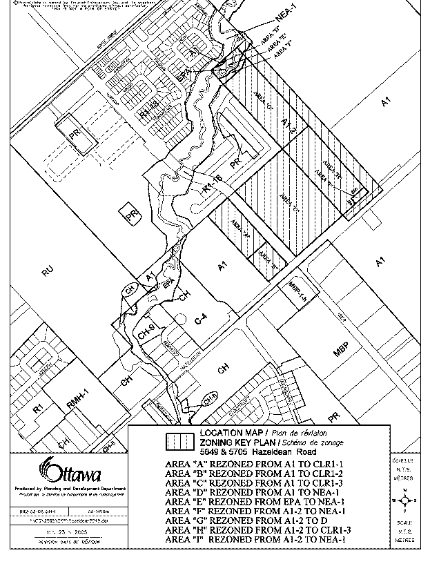
Document 1 Location Map
Document 2 Draft Plan of
Subdivision
Document 3 Conceptual Site Plan:
Overall Shopping Centre
Document 4 Conceptual Site Plan:
Automotive Service Centre
Document 5 Conceptual
Elevations: Automotive Service Centre/Convenience Store
Document 6 Details
of Recommended Zoning
Document
7 Consultation Details
DISPOSITION
City Clerk’s Branch, to notify the owners,
North American (Goulbourn Corporation) (Attn: Terrence Coughlin), 2851 John
Street, Suite 1, Markham, ON L3R 5R7,
and Waldo and Ann Hordijczuk, RR #1, Arnprior, ON K7S 3G7, the applicant, Kathleen Willis, 6393 Roslyn Street,
Orleans, ON, K1C 2Z9, OttawaScene.com, 174 Colonnade Road, Unit #33, Ottawa,
ON K2E 7J5,
Ghislain Lamarche, Program Manager, Assessment, Financial Services Branch (Mail
Code: 26-76) of City Council’s
decision.
Planning, Transit and the Environment
Department to prepare the implementing by-law, forward to Legal Services Branch
and undertake the statutory notification.
Legal Services Branch to forward the
implementing by-law to City Council.
LOCATION MAP DOCUMENT
1
DRAFT PLAN OF SUBDIVISION DOCUMENT
2
CONCEPTUAL SITE PLAN: OVERALL SHOPPING CENTRE DOCUMENT 3
CONCEPTUAL SITE PLAN: AUTOMOTIVE SERVICE DOCUMENT
4
CENTRE
CONCEPTUAL ELEVATIONS: AUTOMOTIVE SERVICE DOCUMENT
5
CENTRE/CONVENIENCE STORE
DETAILS OF RECOMMENDED ZONING DOCUMENT
6
1. Schedule “A” (Maps 1 and 2) of By-law Number 40-99 of the former Township of Goulbourn is amended by rezoning the lands shown as Areas “A”, “B”, “C”, “D”, “E”, “F”, “G”, “H” and “I” on Document 1 as follows:
a) Area “A” is rezoned from “A1” (Agriculture) to “CLR1-1” (Community Level Retail 1, Exception 1)
b) Area “B” is rezoned from “A1” (Agriculture) to “CLR1-2” (Community Level Retail 1, Exception 2)
c) Area “C” is rezoned from “A1” (Agriculture) to “CLR1-3” (Community Level Retail 1, Exception 3)
d) Area “D” is rezoned from “A1” (Agriculture) to “NEA-1” (Natural Environment Area, Exception 1)
e) Area “E” is rezoned from “EPA” (Environmental Protection Area) to “NEA-1” (Natural Environment Area, Exception 1)
f) Area “F” is rezoned from “A1-2” (Agriculture, Exception 2) to “NEA-1” (Natural Environment Area, Exception 1)
g) Area “G” is rezoned from “A1-2” (Agriculture, Exception 2) to “D” (Future Development)
h) Area “H” is rezoned from “A1-2” (Agriculture, Exception 2) to “CLR1-3” (Community Level Retail 1, Exception 3)
i) Area “I” is rezoned from “A1-2” (Agriculture, Exception 2) to “NEA-1” (Natural Environment Area, Exception 1)
2. The text of the former Township of Goulbourn Zoning By-law Number 40-99 shall be amended to add the following section immediately following Section 16A (Community Level Retail Zone):
SECTION 16B - COMMUNITY LEVEL RETAIL 1 ZONE (CLR1)
(1)
PERMITTED USES
No person shall within any “CLR1” zone use any lot or erect, alter or use any building or structure for any purpose, except one or more of the following “CLR1” uses, namely:
(a) RESIDENTIAL USES:
· Dwelling, apartment
· Senior citizen apartment
(b) NON-RESIDENTIAL USES:
· Amusement arcade
· Artist studio
· Assembly hall
· Automotive parts and accessories store
· Bake shop
· Bank
· Bed and breakfast establishment
· Building supply outlet
· Catering establishment
· Clinic
· Club, private
· Convenience store
· Day nursery
· Dry cleaning or laundry outlet
· Equipment rental establishment
· Funeral home
· Garden centre
· Hotel
· Laundromat
· Office, business
· Office, professional
· Parking lot
· Patio (Commercial)
· Place of worship
· Pub
· Recreational establishment
· Restaurant
· Restaurant, fast food
· Restaurant, take-out
· Retail store, which may also be engaged in manufacturing on the premises, provided such manufacturing is accessory to such retail business and the products manufactured are primarily for sale at retail on the premises
· Retirement lodge
· Secondhand shop
· School, other
· School, private
· Service shop, business
· Service shop, merchandise
· Service shop, personal
· Shopping centre, containing any of the uses listed in this zone
· Shopping plaza, containing any of the uses listed in this zone
· Small engine equipment sales
· Taxi stand
· Tourist establishment
· Veterinary clinic
(2)
ZONE PROVISIONS
No person shall within any “CLR1” zone use any lot or erect, alter or use any building or structure except in accordance with the following provisions:
(a) Lot area: (minimum) 600 m²
(b) Lot frontage: (minimum) 18 m
(c) Yard, front: (minimum) 0 m
(d) Yard, exterior side: (minimum) 0 m
(e) Yard, interior side: (minimum) 0 m
(f) Yard, rear: (minimum) 10 m
(g) Lot Width Occupied by Buildings:
(i) A minimum of 50% of the lot width within 3.0 metres of the Front Lot Line must be occupied by building walls if the lot is less than 90 metres wide;
(ii) A minimum of 30% of the lot width within 3.0 metres of the Front Lot Line must be occupied by building walls if the lot is 90 metres in width or wider;
(iii) If there are high voltage power lines present near the Front Lot Line, then the requirement in (i) and (ii) above is 5.0 metres instead of 3.0 metres;
(iv) Where a patio or outdoor amenity area is located between a Building and the Front Lot Line, then the requirement in (i) and (ii) above is 6.0 metres instead of 3.0 metres; and
(v) In the case of phased development where all phases are shown on a site plan approved pursuant to Section 41 of the Planning Act, each phase itself does not have to meet the requirements of (i) and (ii) above, provided that those requirements are satisfied upon the completion of all phases of development.
(h) Buffer strip requirements:
Notwithstanding Subsection 3(3):
(i) a Buffer Strip with a minimum width of 10 metres shall be provided along the full length of any Lot Line adjacent to a residential zone;
(ii) a Buffer Strip with a minimum width of 3 metres shall be provided between a Street Line and a Parking Area or drive aisle;
(iii) a Buffer Strip with a minimum width of 2.5 metres shall be provided between a Side Lot Line and a Parking Area or drive aisle; and
(iv) a Buffer Strip with a minimum width of 5 metres shall be provided along the full length of a Rear Lot Line adjacent to a non-residential zone.
(i) Lot coverage: (maximum) 50%
(j) Building height: (maximum)
(i) Within 20 metres of a lot line abutting a residential zone: 11 m
(ii) In all other cases: 15 m
(k) Open Storage:
No open storage of goods or materials shall be permitted except in accordance with the following provisions:
(i) Every open storage use shall be accessory to the Use of the Building, Main on the Lot;
(ii) An open storage use shall not be permitted in a Yard, Front;
(iii) Every open storage use shall be screened from view from abutting Streets and abutting non-commercial Zones; and
(iv) No open storage use shall cover more than 20% of the Lot Area.
(l) Other provisions:
(i) The lot line adjacent to Hazeldean Road shall be deemed to be the Front Lot Line.
(ii) For any Building, or part of a Building, located within 50 metres of a Street Line other than a Front Lot Line, the nearest part of the Building must be located within 3 metres of the Street Line. Notwithstanding the foregoing, if a patio or outdoor amenity area is located between a Building and a Street Line, the nearest part of the Building must be located within 6 metres of the Street Line.
(iii) Notwithstanding Subsection 2(151), a Shopping Centre shall mean one or more buildings designed, developed and managed as a unit primarily for commercial uses and having the required off-street parking provided on the same lot.
(iv) Notwithstanding subclause 3(16)(a)(ii), the parking rate for a Shopping Centre use shall be a minimum of 3.4 parking spaces per 100 square metres of gross floor area. Furthermore, the minimum number of required parking spaces shall be reduced by the number of on-street parking spaces that are located within 12 metres of the lot where the Shopping Centre is located.
(v) Notwithstanding Subsection 2(109), a parking space shall have a minimum width of 2.6 m.
(m) General provisions:
(i) In accordance with the provisions of Section 3 hereof, unless otherwise stated above.
(3)
SPECIAL
CLR1 ZONES
(a)
CLR1-1 ZONE
All of the provisions of the “CLR1” zone shall apply except those contrary to the following:
(i) The lot line adjacent to Huntmar Drive shall be deemed to be the front lot line.
(ii) The minimum interior side yard for a side lot line adjacent to a residential zone shall be 10 metres.
(b)
CLR1-2
ZONE
All of the provisions of the “CLR1” zone shall apply except those contrary to the following:
(i) An Automotive Service Centre and an Automotive Car Wash are additional permitted uses.
(ii) Notwithstanding Subsection 2(16) of this Zoning By-law, an “Automotive Service Centre” means any Building or Structure or part thereof where vehicle fuel or lubricants are offered for retail sale but where no provisions are made for the repair or maintenance of vehicles. For the purpose of this definition, automated banking machines and the sale of associated convenience items serving the traveling public, including the sale of foods prepared on the site for consumption off the premises, may be permitted in conjunction therewith.
(iii) Notwithstanding Subsection 3(16) of this Zoning By-law, a minimum of 10 stacking spaces are required for an Automotive Car Wash designed for mechanical operation.
(iv) Notwithstanding Subsection 3(16) of this Zoning By-law, the parking rate for an Automotive Service Centre shall be a minimum of 1 parking space per 17 sq. m. of Gross Floor Area.
(v)
Clause
16B(2)(g) and subclause 16B(2)(l)(ii) shall not apply to an Automotive Car Wash
building, an Automotive Service Centre building, and an associated refueling
area canopy.
(vi)
The nearest part of any building containing an
Automotive Service Centre use must be located within 11 metres of the Front Lot
Line.
(vii)
The minimum rear yard is 5 metres.
(c)
CLR1-3
ZONE
All of the provisions of the “CLR1” zone shall apply except those contrary to the following:
(i) All of the lands within the “CLR1-3” zone are considered to be one lot for zoning purposes, notwithstanding the lawful division of a lot pursuant to the Planning Act, as amended, the Condominium Act, as amended, or any other similar legislation.
(ii) A Buffer Strip with a minimum width of 10 metres shall be provided along the full length of any Lot Line adjacent to a “D” (Future Development) zone.
(iii) A Buffer Strip shall not be required along a Lot Line adjacent to an “NEA-1” (Natural Environment Area, Exception 1) zone.
(iv) Maximum building height:
-within 20 m of a lot line abutting a residential zone or a “D” (Future Development) zone: 11 m
-in all other cases: 35 m
CONSULTATION DETAILS DOCUMENT
7
NOTIFICATION AND CONSULTATION PROCESS
Notification and public consultation
was undertaken in accordance with the Public Notification and Public
Consultation Policy approved by City Council for Zoning By-law amendments. One public meeting was also held in the
community on February 2, 2006, for the concurrent subdivision application.
SUMMARY OF PUBLIC INPUT
[U1]
1)
Comment: Does the community have to pay for
the land for the extension of Huntmar Drive, the construction of the transit
corridors and/or the widening of Hazeldean Road?
Response: The land for the extension of Huntmar Drive
has already been transferred to the City through the residential subdivision
application to the north of the site.
At the time of the registration of the subdivision for the subject
property and the adjacent subdivision to the east, the owners will convey the
Hazeldean Road widenings and the future rapid transit corridor and station to
the City. All of the transfers will be
at no cost to the City.
Development charges, which are
collected from developers, will finance approximately 95% of the capital costs
for the Huntmar Drive extension and the widening of Hazeldean Road, subject to
the criteria established in the Development Charge By-law. Arterial road projects are typically subject
to approximately 5% of the funding coming from general tax revenues. For the rapid transit corridor and station,
approximately 48% of the capital cost is funded through development charges and
52% is funded from general tax revenues.
2)
Comment: The construction of Huntmar Drive
would be beneficial to the community.
There is currently a lot of pressure for people who live on Johnwoods
Street, and another road is needed to relieve the pressure.
Response: The Huntmar Drive extension from Maple Grove
Road to Hazeldean Road is currently under construction and is expecting to open
the road in 2007.
3)
Comment: Is there a timeline for the
development?
Response: The development timelines are dependent on
the owner’s progress with leasing the proposed space to prospective
tenants. To date, the owner has not
provided a timeline to commence construction.
Site plan approval is required prior to the construction of any
buildings. A site plan application has not been submitted to date.
4)
Comment: Will this commercial development
be similar to another Kanata Centrum?
Response: The type of tenants would likely be similar
to those at Kanata Centrum with a mix of anchor tenants, medium-size box
stores, and smaller service commercial uses.
However, the development form and characteristics will be different
including the street and block pattern, traffic flow, and the building siting
and orientation. As a condition of draft plan approval, the owner will be
submitting an urban design brief and a Master Site Plan to address the physical
organization and character for the shopping centre.
5)
Comment: Three entrances are proposed on
Hazeldean Road, which seems to be too much for the frontage.
Response: The owner will be required to submit a
Transportation Impact Study through the site plan approval processes to address
the location and type of accesses proposed on Hazeldean Road.
6)
Comment: Will the development offer
prospects for improved livability? Will
residential developments be able to go above the stores?
Response: The proposed zoning will allow for a mix of
uses and would permit office or apartment buildings with ground floor
retail. The City has also requested the
applicant to demonstrate how the site can be intensified in the future with a
transit-oriented development form near the future rapid transit station. These features can improve livability by
creating a more pedestrian-oriented environment that allows the opportunity to
live, work and shop in the same area.