Report to/Rapport au :
Agriculture and Rural Affairs Committee
Comité de l'agriculture et des questions rurales
July 23 2007 / le 23 juillet 2007
Submitted by/Soumis par : Nancy Schepers, Deputy
City Manager / Directrice municipale adjointe,
Planning, Transit and the Environment / Urbanisme, Transport en commun et
Environnement
Contact Person/Personne ressource : Carol
Christensen, Manager/Gestionnaire, Environmental Sustainability/Durabilité de
l’environnement, Economic and Environmental Sustainability/Viabilité économique
et de la durabilité de l’environnement
(613) 580-2424 x21610, Carol.Christensen@ottawa.ca
|
SUBJECT: |
|
|
|
|
|
OBJET : |
REPORT RECOMMENDATIONS
That Agricultural and Rural Affairs Committee recommend City Council:
1. Approve
the Constance Bay Environmental Management Plan (Dillon Consulting Ltd., May
2007); and
2. Approve
the filing of the Constance Bay Environmental Management Plan for the 30-day
public review period in accordance with the Ontario Environmental Assessment
Act.
RECOMMANDATIONS DU RAPPORT
Que le Comité de
l’agriculture et des affaires rurales recommande au Conseil municipal :
1. d’approuver le Plan de
gestion environnementale de Constance Bay (Dillon Consulting Ltd., mai 2007);
2. d’approuver le dépôt du
Plan de gestion environnementale de Constance Bay pour une période d'examen
public de 30 jours, conformément à la Loi sur les évaluations
environnementales.
EXECUTIVE SUMMARY
Assumptions and Analysis:
The Community Design Plan for the Village of Constance Bay was approved by City Council on May 24, 2006 (http://ottawa.ca/calendar/ottawa/citycouncil/occ/2006/05-24/arac/ACS2006-PGM-POL-0029.htm). The Community Design Plan recommended that an Environmental Management Plan be prepared for new development lands within the village boundary to determine environmental and stormwater management requirements to support development and mitigate impacts on the environment.
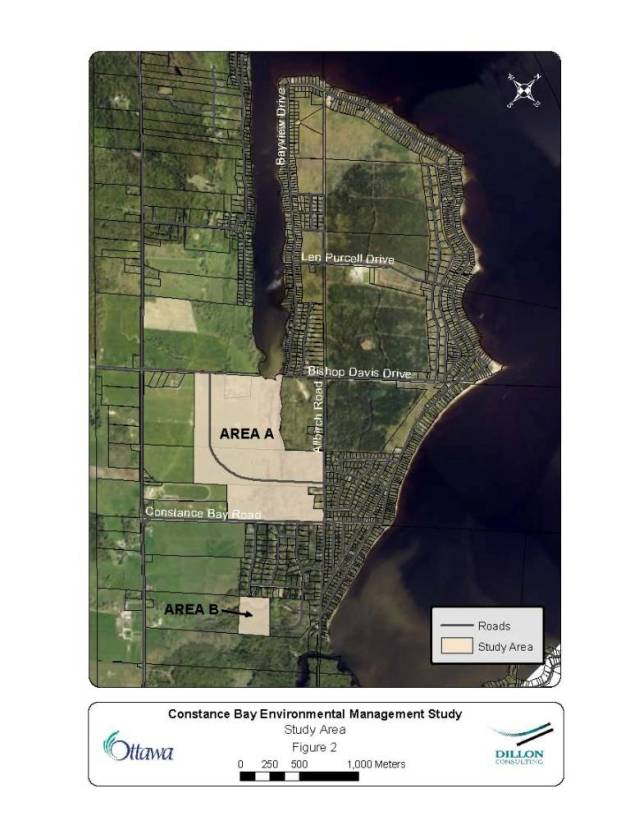
The new development lands that comprise the study area for the Environmental Management Plan are shown on Document 2 - Study Area. Two separate areas are indicated: Area A, bordering Buckham's Bay, and Area B, a block of land located at the far southeast corner of the village. The total area of new development lands is approximately 110 hectares.
Environmental Constraints:
The Official Plan identifies environmental features and constraints that are to be considered when planning for development. These include significant natural features, surface and groundwater features, fish habitat and various natural hazards. A combination of background research and field investigations was employed to determine the features and constraints to development that are present within the study area. The extents of the various features and constraints identified for Area A and Area B are illustrated, respectively, in Documents 3 and 4.
Development Limits:
Environmental constraints are used to identify the limits of development. Where multiple constraints exist in a given area, the constraint with the greatest extent governs as the development limit, thus ensuring that all constraints are respected. Development limits can be further refined through Environmental Impact Studies at the time of development. The development limits determined for Area A and Area B are illustrated, respectively, in Documents 5 and 6.
Groundwater Resources:
A shallow sand aquifer covers the majority of the area and is vulnerable to surface impacts such as road salt and discharges of septic systems. Based on the results of a sampling program completed in 2005, septic loading appears to be an issue in the village with elevated concentrations of nitrates being identified. The new development areas will have to be supported by further detailed studies confirming the feasibility of private services and that existing wells will not be impacted by new development.
Stormwater Management:
Development of the approximately 110 hectares of new development lands within the village will generate increased runoff and pollutant wash-off with resulting impacts on existing tributaries, natural features, and the Ottawa River unless mitigative measures are implemented. A range of stormwater management practices (lot level, conveyance and end-of-pipe) were evaluated to select a preferred approach for each separate area that would best meet the stormwater management criteria. The recommended stormwater management measures are:
Area A West:
Stormwater management practices will include reduced lot grading, roof leaders to grassed areas, grassed swales/roadside ditches and a wet pond. The conceptual pond location is illustrated in Document 7.
Area A East and Area B:
Stormwater management practices
will include reduced lot grading, roof leaders to grassed areas, and grassed
swales/roadside ditches. The predominantly sandy soils in these areas will
allow for significant infiltration, likely precluding the need for wet pond
facilities.
Financial
Implications:
The development proponents will undertake design and construction of the stormwater management works recommended. These works are not included in any of the current Area-Specific Stormwater Development Charge By-laws. However, should development not proceed in advance of the 2009 update to the current Development Charge By-law, then the proposed stormwater management facility could be included in the update. In that case, the stormwater management facility would be front-ended, as per the City’s policy, by the development proponent(s) with reimbursement of costs through development charges collected in the benefiting area.
Public
Consultation/Input:
An Open House was held in Constance Bay on February 4, 2006. Staff from all interested City branches and Mississippi Valley Conservation were consulted throughout the preparation of the Environmental Management Plan. The owners of the new development lands were also consulted and their comments and concerns addressed. This consultation effort fulfilled the requirements specified in the Municipal Engineers Association Class Environmental Assessment document for Schedule B projects.
The Ward Councillor participated in the Open House in February 2006 and also attended the Rural Issues Advisory Committee meeting on June 19, 2007 at which City staff made a presentation about the Environmental Management Plan:
http://ottawa.ca/calendar/ottawa/citycouncil/riac/2007/06-19/Constance%20Bay%20EMP%20RIAC.htm.
Subject to City Council approval, a Notice of Completion will be published for the Environmental Management Plan notifying the public of the availability of the report and the 30-day public review period.
RÉSUMÉ
Hypothèses et analyse :
Le Plan de conception communautaire du village de Constance Bay a été
approuvé par le Conseil municipal le 24 mai 2006
(http://ottawa.ca/calendar/ottawa/citycouncil/occ/2006/05-24/arac/ACS2006-PGM-POL-0029.htm).
Il recommande la préparation d’un plan de gestion environnementale avant
l’aménagement de terrains à lotir sur le territoire du village. Ce plan permettra
de déterminer les besoins en matière de gestion de l’environnement et des eaux
pluviales pour faciliter l’aménagement du territoire et réduire les
répercussions sur le milieu.
Le secteur d’aménagement constituant la zone à l’étude définie pour le plan
de gestion environnementale est montré dans le document 2 sous la rubrique «
Zone à l’étude ». Deux zones différentes sont indiquées : la zone A, qui borde
Buckham’s Bay, et la zone B, une parcelle située dans la partie la plus au
sud-est du village. La superficie totale du secteur d’aménagement est d’environ
110 hectares.
Contraintes environnementales :
Le Plan officiel relève des particularités et des contraintes
environnementales dont il faut tenir compte au moment de planifier
l’aménagement. Les caractéristiques naturelles importantes, les eaux
souterraines et de surface, l’habitat des poissons et les divers risques
naturels en sont quelques exemples. Les caractéristiques et les contraintes
pouvant affecter l’aménagement ont été déterminées dans le cadre de recherches
préliminaires et d’enquêtes sur le terrain dans la zone à l’étude. Les
caractéristiques naturelles et les contraintes des zones A et B sont décrites
dans les documents 3 et 4 respectivement.
Limites de l’aménagement :
Les contraintes environnementales sont utilisées à titre de référence pour
déterminer les limites de l’aménagement. Dans un secteur donné comptant
plusieurs contraintes, celle ayant la plus grande portée servira de balise pour
fixer les limites de l’aménagement, de manière à assurer ainsi le respect de
toutes les autres contraintes. Une étude sur les incidences environnementales
effectuée au moment de l’aménagement peut permettre d’en préciser les limites.
Les limites de l’aménagement des zones A et B sont définies dans les documents
5 et 6 respectivement.
Ressources en eau souterraine :
Une mince couche de sable aquifère recouvre la presque totalité de la zone,
rendant le terrain vulnérable à des contaminations, p. ex., par le sel de
voirie et le débordement des systèmes septiques. Selon les résultats d’un
programme d’échantillonnage qui s’est terminé en 2005, il semble que l’apport
de polluants dans le système septique de ce village constitue un problème, car
des concentrations élevées de nitrate y ont été relevées. Des études détaillées
devront être effectuées avant le début de l’aménagement pour confirmer que le
secteur peut être pris en charge par des services privés et que les puits
existants ne seront pas affectés par les lotissements prévus.
Gestion des eaux pluviales :
L’aménagement d’environ 110 hectares à lotir dans le village fera augmenter
le ruissellement, qui entraînera des matières polluantes dans son sillage. À
moins d’instaurer des mesures d’atténuation, les affluents, les
caractéristiques naturelles et la rivière des Outaouais en subiront les
conséquences. Une série de mesures de gestion des eaux pluviales (gestion
individuelle, adduction des eaux et installations de traitement au point de
rejet) ont été évaluées dans le but de sélectionner la meilleure approche pour
chaque zone afin de répondre aux critères de gestion des eaux pluviales. Voici
les mesures de gestion des eaux pluviales recommandées :
Zone A Ouest :
Les mesures de gestion des eaux pluviales comprendront le moins de
terrassement possible, des tuyaux de descente des eaux pluviales vers des zones
gazonnées et des rigoles de drainage gazonnées ou des fossés, ainsi qu’un
bassin de rétention. L’emplacement du bassin est indiqué dans le document 7.
Zone A Est et zone B :
Les mesures de gestion des eaux pluviales comprendront le moins de
terrassement possible, des tuyaux de descente des eaux pluviales vers des zones
gazonnées et des rigoles de drainage gazonnées/fossés. Les sols sablonneux,
prédominants dans cette zone, permettront à l’eau de s’infiltrer facilement,
éliminant sans doute le besoin d’aménager un bassin de rétention.
Répercussions financières
Les promoteurs désirant aménager le secteur devront entreprendre la
conception et la construction des installations de gestion des eaux pluviales
conformément aux mesures préconisées. Ces mesures ne sont pas mentionnées dans
les règlements municipaux sur les redevances d’aménagement des installations de
traitement des eaux pluviales s’appliquant à chaque zone. Toutefois, si l’aménagement
n’est pas effectué avant la prochaine mise à jour en 2009 du règlement sur les
redevances d'exploitation existant, il sera possible de tenir compte des
installations de gestion des eaux pluviales proposées dans la mise à jour. Le
cas échéant, les coûts des installations de gestion des eaux pluviales
proposées seront assumés, conformément à la politique de la Ville, par le
promoteur et ensuite remboursés au moyen des redevances d’aménagement perçues
pour le secteur.
Répercussions financières :
Les promoteurs désirant aménager le secteur devront entreprendre la
conception et la construction des installations de gestion des eaux pluviales
conformément aux mesures préconisées. Ces mesures ne sont pas mentionnées dans
les règlements municipaux sur les redevances d’aménagement des installations de
traitement des eaux pluviales s’appliquant à chaque zone. Toutefois, si
l’aménagement n’est pas effectué avant la prochaine mise à jour en 2009 du
règlement sur les redevances d'exploitation existant, il sera possible de tenir
compte des installations de gestion des eaux pluviales proposées dans la mise à
jour. Le cas échéant, les coûts des installations de gestion des eaux pluviales
proposées seront assumés, conformément à la politique de la Ville, par le promoteur
et ensuite remboursés au moyen des redevances d’aménagement perçues pour le
secteur.
Consultation publique / commentaires :
Une séance de consultation publique a eu lieu le 4 février 2006 à Constance
Bay. Les responsables de tous les services municipaux intéressés et de l’Office
de protection de la nature de la vallée du Mississippi ont été consultés tout
au long de la préparation du Plan de gestion environnementale. Les
propriétaires des terrains à lotir ont aussi été consultés afin que l’on puisse
recueillir leurs commentaires et répondre à leurs questions. Ces consultations
ont été menées conformément aux exigences énoncées dans le document de la
Municipal Engineers Association de l’Ontario sur les évaluations
environnementales de portée générale pour les projets prévus à l’annexe B.
Le conseiller municipal du secteur a participé à ces réunions publiques. Il
a aussi assisté à la réunion du Comité consultatif sur les questions rurales
qui a eu lieu le 19 juin 2007 et au cours de laquelle le personnel de la Ville
a présenté le Plan de gestion environnementale
(http://ottawa.ca/calendar/ottawa/citycouncil/riac/2007/06-19/Constance%20Bay%20EMP%20RIAC.htm).
Comme le Plan de gestion environnementale est soumis à l’approbation du
Conseil municipal, un avis d’achèvement sera publié pour informer le public de
la parution du rapport et du début de la période d’examen public de 30 jours.
BACKGROUND
The Community Design Plan for the Village of Constance Bay was approved by City Council on May 24, 2006 (http://ottawa.ca/calendar/ottawa/citycouncil/occ/2006/05-24/arac/ACS2006-PGM-POL-0029.htm). The Community Design Plan recommended that an Environmental Management Plan be prepared for new development lands within the village boundary to determine environmental and stormwater management requirements to support development and mitigate impacts on the environment. The Environmental Management Plan has now been completed (Document 1, distributed under separate cover).
The objectives of the Environmental Management Plan are to:
i) identify development limits based upon natural features to be protected and natural hazards such as steep slopes and unsuitable soils;
ii) identify areas where further study is needed to protect natural features;
iii) recommend stormwater management measures to mitigate the impacts of development on receiving watercourses; and
iv) address the requirements of the Ontario Environmental Assessment Act for the recommended stormwater management infrastructure.
The new development lands that comprise the study area for the Environmental Management Plan are shown on Document 2 - Study Area. Two separate areas are indicated: Area A, bordering Buckham's Bay, and Area B, a block of land located at the far southeast corner of the village. The total area of new development lands is approximately 110 hectares.
DISCUSSION
Environmental Constraints:
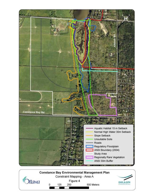
The Official Plan identifies environmental features and constraints that are to be considered when planning for development. These include significant natural features, surface and groundwater features, fish habitat and various natural hazards. A combination of background research and field investigations was employed to determine the features and constraints to development that are present within the study area.
A low lying area in Area A presents a number of constraints to development, including warmwater fish habitat, floodplain, and organic soils which are unsuitable for development. The slopes and ravines along the western edge of this low lying area are also steep and unstable.
The lands on either side of the low lying area in Area A are referred to as Area A West and Area A East. No environmental constraints were identified in the agricultural fields comprising Area A West. Area A East is still in a natural wooded state. It abuts the provincially significant Constance Bay Sandhills Area of Natural and Scientific Interest (ANSI), which is designated as a Natural Environment Area in the Official Plan (2003). A regionally significant forest community dominated by Red Oak was identified in Area A East. Four regionally significant floral species were identified in the southeast portion of this forest community. The extent of the constraints identified for Area A West and Area A East is illustrated in Document 3.
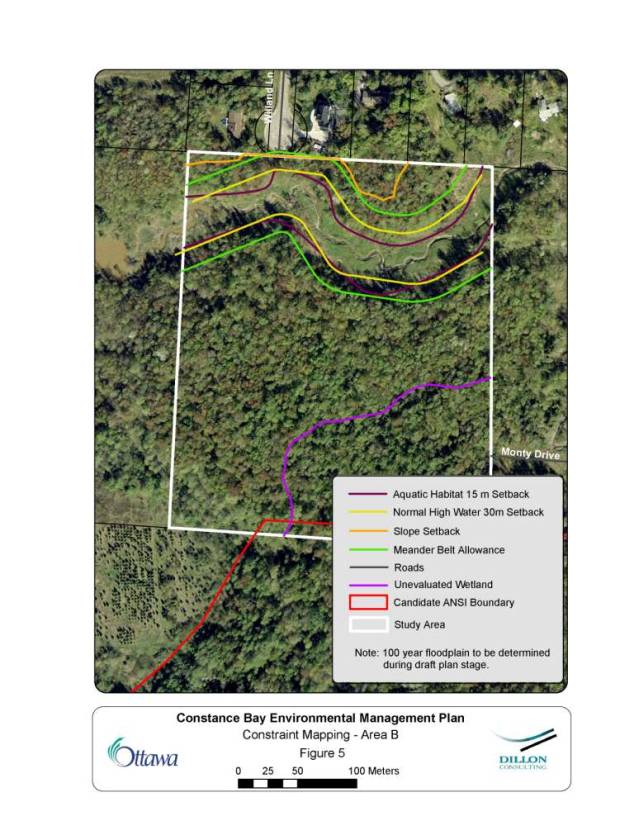
The northern part of Area B is traversed by a tributary of Constance Creek, which, like the low lying area in Area A, presents a number of constraints to development. These constraints include setbacks for the protection of fish habitat and surface water features, as well as steep and unstable slopes. The regulatory floodplain has not yet been determined for this section of the creek. Further study by the development proponent will be required to confirm the limit of the regulatory floodplain in this area. In the southeast corner of Area B there is a Black Ash swamp. This forested wetland community is located approximately 300 meters from the Constance Creek Provincially Significant Wetland (PSW) boundary. Further study by the development proponent, including additional investigation and consultation with the Ministry of Natural Resources, will be required to determine the relationship between the Black Ash swamp and the Constance Creek PSW. The extent of the constraints identified for Area B is illustrated in Document 4.
Development Limits:
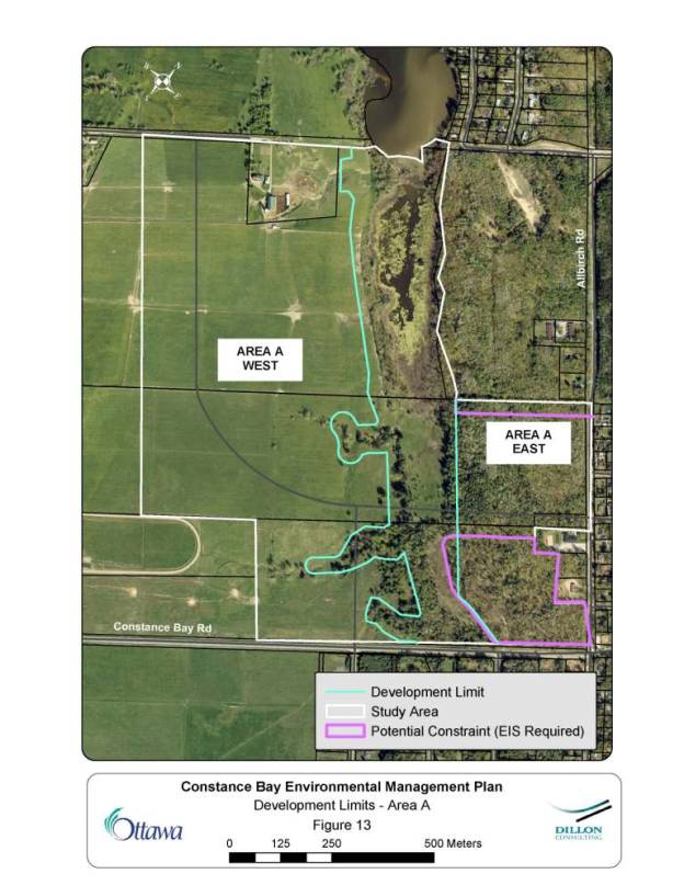
Environmental constraints are used to identify development limits, which is one of the principal objectives of the EMP. Where multiple constraints exist in a given area, the constraint with the greatest extent governs as the development limit, thus ensuring that all constraints are respected. For the Constance Bay study area, the developable land is located in three principal sections. In Area A, the developable lands are located east and west of the low lying area southeast of Buckham’s Bay.
The developable area in Area A West is approximately 54 ha in size, and is relatively unconstrained from a natural environment perspective due to its past use as agricultural fields. The development limit in this area is established by the stable slope setback.
The developable land in Area A East is approximately 18 ha in size and is primarily in a natural wooded state. The development limit in this area is established by the presence of unsuitable (organic) soils in the low-lying area that bisects Area A. An Environmental Impact Statement (EIS) will be required as part of the development application process for developments within the southeast portion of the regionally significant forest community or within 30 meters of the provincially significant Area of Natural and Scientific Interest. Development in this area should be designed to retain as much as possible of the regionally significant forest community and the regionally rare floral species. A buffer of natural vegetation should also be retained along the edge of the ANSI. The width of this buffer will be determined through the preparation of the EIS.
Development limits for Area A (West and East) are illustrated in Document 5.
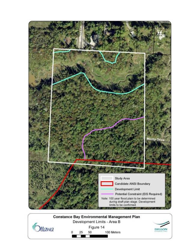
In Area B, the creek that traverses the northern portion of the property defines the northern development limits. There is no appreciable amount of developable land north of the creek. The development limit along the south edge of the creek valley will be the greater of the meander belt allowance shown in the EMP or the 100 year flood line, which must be confirmed by the development proponent as part of the development application process. The remaining developable area is approximately 5.6 ha. An EIS will be required to examine the wetland on the property and, in consultation with the Ministry of Natural Resources, determine its relationship to the Constance Creek PSW. Development limits for Area B are illustrated in Document 6.
Groundwater Resources
Recommendations for the protection of groundwater resources have been based upon the results of the Village of Constance Bay Groundwater Study (Dillon, 2006) and are summarized as follows:
A shallow sand aquifer covers the majority of the area and is vulnerable to surface impacts such as road salt and cumulative impacts from discharges of septic systems. Based on the results of a sampling program completed in 2005, septic loading appears to be an issue in the village. While the detection of bacteria was not widespread, nitrate concentrations were elevated, particularly in locations of relatively high residential density. The elevated concentrations identified are considered significant. As such, the new development areas will have to be supported by further detailed studies confirming the feasibility of private services and that existing wells will not be impacted by new development. Specific recommendations include:
i) New development within the Village should take into account the observed build-up of nitrates in the overburden sand aquifer and take measures to minimize additional nitrate loading. New landowners should be educated on the sensitivity of the local aquifer to environmental threats and encouraged to have their water tested on a regular basis for bacteria and nitrates;
ii) Unused wells should be identified prior to development, and their abandonment be a condition of subdivision approval;
iii) Each new lot should identify a spare weeping tile bed;
iv) For development on marginal terrain that may exist in the clayey areas along the western portion of Area A (see Document 1), consideration should be given to developing in phases, with proof of favourable operation of earlier phases being required prior to approving later phases;
v) Road salting practices in the new development area should be reviewed in an effort to minimize salt application quantities; and
vi) Site specific assessments should be performed for all new subdivision developments and be consistent with the 1995 MOE guidance manuals: Procedure D-5-4 Technical Guideline for Individual On-Site Sewage Systems: Water Quality Impact Risk Assessment; and Procedure D-5-5 Technical Guidelines for Water Supply Assessment. The City and proponent should agree on the scope of the impact study prior to initiation. Proponents should be made aware of the existing nitrate concerns such that the required site-specific hydrogeological studies can adequately take this into consideration.
Stormwater Management:
Development of the approximately 110 hectares of new development lands within the village will generate increased runoff and pollutant wash-off with resulting impacts on existing tributaries, natural features, and the Ottawa River unless mitigative measures are implemented.
As detailed in the Constance Bay Groundwater Study (Dillon, 2006), required lot sizes in the new development areas have not been recommended as more detailed study is required to confirm this. However, for the purpose of assessing the impacts of development and recommending a conceptual stormwater management plan, an estimated average lot size of 0.5 hectare and a total imperviousness of 10 percent were assumed.
To determine the required approach to mitigating the impacts of urbanization on receiving watercourses, stormwater management criteria were first confirmed. Separate criteria were tailored to three different areas (Area A West, Area A East and Area B) to reflect the varying conditions in each location. The required stormwater management criteria and recommended stormwater management measures to meet these criteria are summarized below.
Stormwater Management Criteria:
Area A West: This area drains directly to the Ottawa River and has clayey soils. Tree cover is limited to the existing ravines/tributaries at the eastern limit of the area.
Stormwater Management Criteria:
i) Quantity control: Quantity control for the 2 to 100 year event is not required as the Ottawa River is insensitive to runoff from this relatively small area.
ii) Erosion control: Erosion control is not required as, again, the Ottawa River is insensitive to runoff from this relatively small area. However, erosion protection measures for the existing ravines to which drainage will be directed may be required. The need for such measures is to be confirmed during detailed design.
iii) Quality control: A "normal" level of protection, representing 70% removal of total suspended solids, is required.
iv) Water balance: Stormwater management practices will be required to replicate pre-development infiltration rates.
Area A East: This area drains directly to the Ottawa River, has sandy soils and extensive tree cover.
Stormwater Management Criteria:
i) Quantity control: Quantity control for the 2 to 100 year event is not required as the Ottawa River is insensitive to runoff from this relatively small area.
ii) Erosion control: Erosion control is not required as, again, the Ottawa River is insensitive to runoff from this relatively small area.
iii) Quality control: A "normal" level of protection, representing 70% removal of total suspended solids, is required.
iv) Water balance: Stormwater management practices will be required to replicate pre-development infiltration rates.
Area B: This area drains to a tributary of Constance Creek and has sandy soils. Tree cover is extensive.
i) Quantity control and erosion control: The need for quantity/erosion control is to be determined during detailed design. (However, given the very sandy soils and low imperviousness of development on private services, it may be possible to mitigate increased runoff volumes through infiltration measures and "design with nature" principles.)
ii) Quality control: A "normal" level of protection, representing 70% removal of total suspended solids, is required.
iii) Water balance: Stormwater management practices will be required to replicate pre-development infiltration rates.
Recommended Stormwater Management Measures:
A range of stormwater management practices (lot level, conveyance and end-of-pipe) were evaluated to select a preferred approach for each separate area that would best meet the stormwater management criteria.
Area A West:
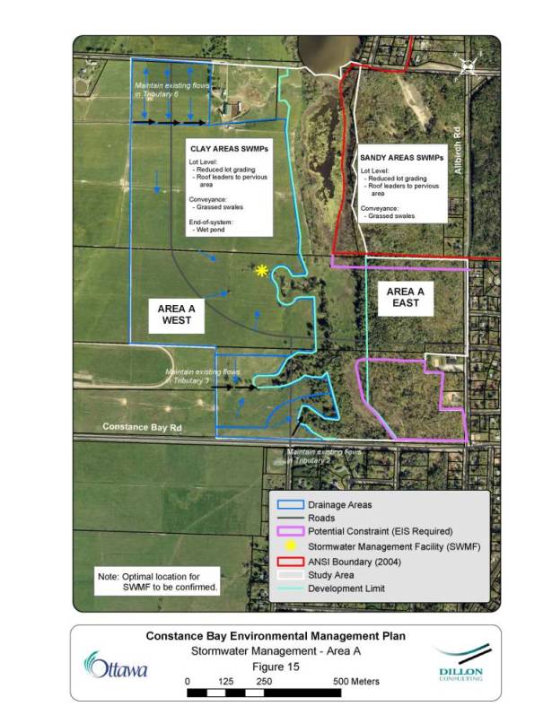
Stormwater management practices will include reduced lot grading, roof leaders to grassed areas, grassed swales/roadside ditches and a wet pond. The conceptual pond location is illustrated in Document 7.
Area A East and Area B:
Stormwater management practices will include reduced lot grading, roof leaders to grassed areas, and grassed swales/roadside ditches. The predominantly sandy soils in these areas will allow for significant infiltration, likely precluding the need for a wet pond facility.
CONSULTATION
An Open House was held in Constance Bay on February 4, 2006. Comments related to the Environmental Management Plan are summarized in Table 1:
|
Table 1 – Comments Received at Open House of February 4, 2006 |
|
|
Comment |
Response |
|
Concern re: mosquitoes and West Nile virus associated with proposed stormwater management pond |
SWM ponds have not been shown to be a significant source of mosquitoes; City does regular monitoring of ponds and this has not been a concern in the past. |
|
Why protect certain plants (Jack Pine) in the ANSI? – What about overall plant community? Why don’t we protect tulips, Patterson Creek? |
The
concern is related to the habitat present that permits rare plant growth. Re: the ANSI, plants will grow wherever the conditions allow but the purpose is not to restrict activity on private lots; some plants found in the ANSI are very rare in the City, even in the province; the aim is to protect the overall plant community. |
|
What
was the purpose of Dan White’s work? |
The
Province designated the ANSI; when this was appealed in 2003, Dan White was
hired to determine if the ANSI designation should hold; City acquired the
land because the ANSI was confirmed. |
|
Isn’t
the ANSI a plantation? |
Yes; however, the “natural” concern is not the production of timber; the plan looks at promoting a return of the native plant community. |
|
Why is new development proposed in an area where high nitrates were found? |
As development proceeds, further detailed studies will be required at the subdivision stage; there is a need to confirm the direction of groundwater flow in detailed studies (i.e., to determine lot sizes, etc.). |
Staff from all interested City branches and Mississippi Valley Conservation were consulted throughout the preparation of the study. The owners of the new development lands were also consulted and their comments and concerns addressed. This consultation effort fulfilled the requirements specified in the Municipal Engineers Association Class Environmental Assessment document for Schedule B projects.
The Ward Councillor participated in the Open House in February 2006 and also attended the Rural Issues Advisory Committee meeting on June 19, 2007 at which City staff made a presentation about the Environmental Management Plan:
http://ottawa.ca/calendar/ottawa/citycouncil/riac/2007/06-19/Constance%20Bay%20EMP%20 RIAC.htm
Subject to City Council approval, a Notice of Completion will be published for the Environmental Management Plan notifying the public of the availability of the report and the 30 day public review period.
FINANCIAL IMPLICATIONS
The development proponents will undertake design and construction of the stormwater management works recommended. These works are not included in any of the current Area-Specific Stormwater Development Charge By-laws. However, should development not proceed in advance of the 2009 update to the current Development Charge By-law, then the proposed stormwater management facility could be included in the update. In that case, the stormwater management facility would be front-ended, as per the City’s policy, by the development proponent(s) with reimbursement of costs through development charges collected in the benefiting area.
SUPPORTING DOCUMENTATION
Document 1 Constance Bay Environmental Management Plan (distributed under separate cover)
Document 2 Study Area
Document 3 Constraint Mapping - Area A
Document 4 Constraint Mapping - Area B
Document 5 Development Limits - Area A
Document 6 Development Limits Area B
Document 7 Stormwater Management - Area A
DISPOSITION
Planning, Transit and the Environment staff will file the Notice of Completion for the Constance Bay Environmental Management Plan to initiate the 30-day public review period of the recommended stormwater management works. Once the Class EA is approved under the Environmental Assessment Act, projects identified in the Environmental Management Plan may proceed to detailed design and final City approval.
STUDY AREA DOCUMENT
2
DEVELOPMENT LIMITS - AREA B DOCUMENT 6
STORMWATER MANAGEMENT - AREA A DOCUMENT 7