APPENDIX C – PRIORITY AREA SITE MAPS
|
7. URBAN NATURAL FEATURES STRATEGY STRATÉGIE
VISANT LES CARACTÉRISTIQUES NATURELLES URBAINES
|
Committee recommendations as
amended
That Council approve:
1. The
Urban Natural Features Strategy, as detailed in Document 1, which identifies
priority urban natural areas for protection through a staged acquisition
program.
2. That
the Capital budget requirements to implement the Urban Natural Features
Strategy for 2008 and beyond, as outlined in this report and the Department’s
Long Range Financial Plan 3, be referred to the 2008 Capital Budget process.
3. That staff prepare information
for residents that would outline several options for achieving the necessary
funding through a levy program, and that this information be available to
residents before significant natural features are clear-cut or drained, and;
That this levy not
be made available for any other purpose.
RecommandationS modifiÉeS du Comité
Que le Conseil :
1. Entérine
la Stratégie visant les caractéristiques naturelles urbaines qui est énoncée
dans le document 1 et qui désigne les espaces naturels urbains devant être
protégés en priorité par l’entremise d’un programme d’acquisition par étapes;
2. Autorise que les sommes à prévoir au budget
des immobilisations pour mettre en œuvre, à compter de 2008, la Stratégie
visant les caractéristiques naturelles urbaines qui sont énoncées dans le
présent rapport et dans le Plan financier à long terme 3 (PFLT 3) du Service,
soient examinées dans le cadre du processus d’élaboration du budget des immobilisations
de 2008.
3. Enjoigne
le personnel à préparer, à l’intention des résidents, des renseignements sur
les diverses options visant à amasser les fonds nécessaires au moyen de
l’imposition d’une taxe spéciale, et que ces renseignements soient mis à la
disposition des résidents avant que des caractéristiques naturelles
d’importance ne soient coupées à blanc ou drainées, et;
Que cette taxe spéciale ne soit en aucun cas utilisée à d’autres fins
que celles pour lesquelles elle aura été perçue.
for the information of council
The following directive was issued
to staff:
WHEREAS
there is a need to revisit the boundaries of UNA site 63 as a result of recent
changes to the location and forestation;
BE
IT RESOLVED that UNA Site 63 be referred to staff to revisit the boundary in
consultation with the owners.
pour la gouverne du conseil
Le personnel a reçu la directive
suivante :
attendu,
qu’il est nécessaire d’examiner de nouveau les limites de l’ENU no 63
à cause de récents changements forestiers au site en question :
IL EST DÉCIDÉ QUE le dossier de l’ENU no 63 sera
acheminé au personnel pour qu’il modifie les limites du terrain en question
après avoir consulté les propriétaires concernés.
Documentation
1.
Deputy
City Manager's report Planning,
Transit and the Environment dated
11 April 2007 (ACS2007-PTE-POL-0002).
2. Extract
of Draft Minutes, 24 April 2007, follows the French version of the report.
Report
to/Rapport au :
Planning and Environment Committee
Comité de l'urbanisme et de
l'environnement
and Council / et au Conseil
Submitted by/Soumis par : Nancy Schepers, Deputy City Manager/
Directrice municipale adjointe
Planning, Transit and the Environment/Urbanisme, Transport en commun et
Environnement
Contact
Person/Personne ressource : Carol Christensen, Manager, Environmental
Sustainability
Planning, Environment and Infrastructure
Policy/Politiques d’urbanisme, d’environnement
et d’infrastructure
(613) 580-2424 x 21610,
Carol.Christensen@ottawa.ca
|
SUBJECT: |
|
|
|
|
|
OBJET : |
REPORT RECOMMENDATIONS
That Planning and Environment Committee
recommend City Council approve:
1.
The Urban Natural Features Strategy, as detailed in
Document 1, which identifies priority urban natural areas for protection
through a staged acquisition program; and,
2.
That the capital budget requirements to implement the
Urban Natural Features Strategy for 2008 and beyond, as outlined in this report
and the Department’s Long Range Financial Plan 3, be referred to the 2008
Capital Budget process.
RECOMMANDATIONS DU RAPPORT
Que le Comité de l'urbanisme et de l'environnement recommande au Conseil
municipal :
1. d’entériner la Stratégie
visant les caractéristiques naturelles urbaines qui est énoncée dans le
document 1 et qui désigne les espaces naturels urbains devant être protégés en
priorité par l’entremise d’un programme d’acquisition par étapes;
2. d’autoriser que les sommes à prévoir au budget des immobilisations pour
mettre en œuvre, à compter de 2008, la Stratégie visant les caractéristiques
naturelles urbaines qui sont énoncées dans le présent rapport et dans le Plan
financier à long terme 3 (PFLT 3) du Service, soient examinées dans le cadre du
processus d’élaboration du budget des immobilisations de 2008.
EXECUTIVE SUMMARY
Assumptions and Analysis:
The Official Plan and Greenspace Master Plan identified the need for Council to adopt an Urban Natural Features Strategy to prioritize the remaining urban natural areas that are worthy of protection based on the Urban Natural Areas Environmental Evaluation Study (UNAEES); and to propose how these areas can be secured for the long term. The purpose of this report is to present for Council's approval the Urban Natural Features Strategy (Document 1). This strategy sets out the City's intentions for protecting a priority list of natural areas in the urban area to be secured through acquisition or other means.
The Urban Natural Features Strategy has analyzed the 192 urban natural areas identified in the UNAEES to determine opportunities and constraints to protecting the natural areas worthy of protection. This analysis is based on the strategic directions, environmental value and planning status of the urban natural area. Each of the urban natural areas have been assigned in whole or in part to four categories:
· Category 1 – Protected Urban Natural Areas
· Category 2 – New Urban Natural Areas – Securement by City required
· Category 3 – Development Approved - Full protection of natural area not being pursued
· Category 4 - Environmental Evaluation Outstanding - Environmental Impact Statement required
These categories reflect natural areas currently protected, new natural areas recommended for protection through securement and natural areas not recommended for full protection due to the level of planning commitments. A total of 19 sites have been identified as priority sites for protection through securement by the City. For the four federally-owned priority sites, planning studies, as directed in the Greenspace Master Plan, will be the mechanism for determining protection potential. For the 15 privately-owned sites, acquisition is required to protect these natural areas. A staged acquisition plan is proposed over 10 years to acquire the 15 privately-owned natural areas identified as a priority for protection.
Financial
Implications:
Real Property and Asset Management (RPAM) services were retained to provide a preliminary land value estimate to purchase the 19 priority natural areas as identified in the Urban Natural Features Strategy. A land value estimate of $64,312,000 has been provided to purchase all 19 priority sites based on status of lands as of May 2006. The value estimate represents the most costly scenario as purchasing the land is assumed as the sole mechanism for securement of the private and publicly-owned priority areas.
The total cost to purchase the 15 privately-owned priority areas based on the land value estimates prepared by RPAM is $38,090,000. The 2007 LRFP3 tabled with Council has put forward the following funding requirements to acquire the 15 privately-owned priority natural features:
2007 - $4,718,000
2008-2016 - $3,708,000 each year extending over a nine-year period based on 2006 values
The 2007 funding requirement was approved by City Council as part of the 2007 budget process. Subject to approval of this report, the recommended funding for 2008 to 2016 will be referred to the 2008 budget process.
Public Consultation/Input:
Public consultation on the Urban Natural Features Strategy was undertaken in conjunction with the Council-approved Greenspace Master Plan. Public information meetings on the strategic directions and implementation recommendations of the Urban Natural Features Strategy were held in June 2005 at six locations across the city, and again on May 2, 2006 at City Hall. A number of additional meetings with stakeholders and landowners also took place on the development of the Urban Natural Features Strategy. These discussions led to the development and further refinements to the Strategy that is before Council in this report.
The Department will meet with affected landowners individually to discuss further the implementation of the Urban Natural Features Strategy.
RÉSUMÉ
Le Plan officiel et le Plan
directeur des espaces verts mentionnent tous deux la nécessité pour le Conseil,
d’une part, d’adopter une stratégie concernant les caractéristiques naturelles
urbaines afin de classer par ordre de priorité les aires naturelles urbaines
qu’il importe de protéger selon l’Étude d’évaluation environnementale des
espaces naturels urbains (EEEENU) et, d’autre part, de proposer une manière de
les préserver à long terme. Le présent rapport a pour but de soumettre la
Stratégie visant les caractéristiques naturelles urbaines (document 1) à
l’approbation du Conseil. Cette stratégie précise comment la Ville compte
protéger divers espaces naturels du secteur urbain jugés prioritaires en en
faisant l’acquisition ou en recourant à d’autres moyens.
Dans le cadre de la Stratégie visant
les caractéristiques naturelles urbaines, le personnel de la Ville a analysé
les 192 espaces naturels urbains recensés dans l’EEEENU afin de cerner les
possibilités et les contraintes relatives à la protection des espaces en cause.
Cette analyse, qui était fondée sur les orientations stratégiques définies à
cette fin, de même que sur la valeur environnementale de chaque espace naturel
et les aménagements y ayant été approuvés, le cas échéant, a permis de classer
tout ou partie des aires naturelles selon quatre catégories :
· catégorie
1 – Espaces naturels urbains protégés;
· catégorie
2 – Nouveaux espaces naturels urbains – espaces que la Ville doit acquérir;
· catégorie
3 – Aménagement approuvé – espaces qui ne seront pas protégés dans leur
intégralité;
· catégorie
4 – Évaluation environnementale incomplète – espaces pour lesquels une étude
d’impact sur l’environnement doit être réalisée.
Ces catégories correspondent aux
espaces naturels déjà protégés, aux nouveaux espaces naturels qu’il est
recommandé à la Ville de préserver en en faisant l’acquisition et aux espaces
qu’il n’est pas recommandé de protéger dans leur intégralité en raison des
aménagements qui y ont déjà été autorisés. En tout, 19 espaces ont été désignés
prioritaires et devraient être acquis par la Ville afin d’en assurer la
protection. Quatre d’entre eux appartiennent au gouvernement fédéral, et des
études de planification seront réalisées conformément au Plan directeur des
espaces verts afin d’en déterminer le potentiel de protection. Les 15 autres
espaces prioritaires appartiennent à des intérêts privés et la Ville devra en
faire l’acquisition si elle souhaite les protéger. Un plan échelonné sur 10 ans
est donc proposé à cette fin.
Répercussions financières :
La Direction de la gestion des
actifs et des biens immobiliers (GBI) a été chargée de fournir une première
estimation des coûts d’achat des 19 espaces naturels désignés comme devant être
protégés en priorité dans la Stratégie visant les caractéristiques naturelles
urbaines. En mai 2006, la valeur de ces 19 espaces a été estimée, dans l’état
actuel des choses, à 64 312 000 $ de dollars. Cette estimation correspond au
scénario le plus coûteux puisqu’elle repose sur l’hypothèse voulant que le seul
moyen d’assurer la protection des aires naturelles publiques et privées
consiste à faire l’acquisition de celles ci.
Selon les estimations préparées par
GBI en fonction de la valeur des terrains, le coût d’achat total des 15 espaces
naturels devant être protégés en priorité qui appartiennent à des intérêts
privés s’élève à 38 090 000 $. Le Plan financier à long terme 3 de 2007 soumis
à l’examen du Conseil prévoit les besoins suivants en matière de financement
pour l’acquisition de ces espaces :
2007 – 4 718 000 $
2008-2016 – 3 708 000 $ par année, pour une période de neuf ans, en
fonction de l’évaluation de 2006
La dimension financière a été
approuvée par le Conseil municipal dans le cadre du processus budgétaire de
2007. Sous réserve de l’approbation du présent rapport, le financement recommandé
pour 2008 jusqu’en 2016 sera traité dans le cadre du processus budgétaire de
2008.
Consultation publique/commentaires :
Des consultations publiques sur la
Stratégie visant les caractéristiques naturelles urbaines ont été menées
parallèlement à celles sur le Plan directeur des espaces verts approuvé par le
Conseil. Des séances d’information publique concernant les orientations
stratégiques et les recommandations relatives à la mise en œuvre de la
Stratégie ont eu lieu en juin 2005 à six endroits de la ville, puis une autre a
été tenue le 2 mai 2006 à l’hôtel de ville. Un certain nombre de réunions avec
divers intervenants et des propriétaires fonciers ont également été organisées
dans le cadre de la Stratégie. Ces rencontres ont conduit à l’élaboration puis
à l’amélioration du document soumis au Conseil dans le présent rapport.
Le Service rencontrera chacun des
propriétaires des espaces visés afin de discuter avec eux de la mise en œuvre
de la Stratégie.
BACKGROUND
Since municipal amalgamation in 2001, Council and the community have systematically developed an environmental basis for City decisions on land use and other corporate responsibilities. Under the 20/20 initiative in 2002, the principle of “A green and environmentally-sensitive city” was set as one of seven principles to guide the Official Plan, the Environmental Strategy, and other plans to manage the growth projected for Ottawa for the next 20 years. The Official Plan advanced the principle by proposing development of a Greenspace Master Plan to set Council policies for all types of greenspace in Ottawa. Within that framework, the Official Plan also required completion of an Urban Natural Areas Environmental Evaluation Study (UNAEES). The objectives of the study were to identify and to assess the relative environmental value of natural areas across the entire urban area, to establish priorities for protection, and make recommendations for management of these lands.
Muncaster Environmental Planning and Brunton Consulting Services were retained in 2002 to undertake the UNAEES. The key objectives of the study were to:
· Identify all candidate sites of 0.8 ha or larger that were physically present on the landscape at the time of the study, regardless of ownership and approvals in place for future development;
· Assess sites based on fieldwork and supplementary existing data;
· Evaluate sites against nine environmental criteria to rate the environmental value of each site;
· Develop broad management recommendations for passive recreational use and conservation of ecological functions.
The study identified 192 urban natural areas and evaluated 177 of these in two seasons of fieldwork. Of the 177 evaluated sites, 41 were rated as having high environmental value, 67 rated moderate and 69 were rated as low environmental value. Of the remaining 15 sites, four were not evaluated because they had been significantly altered since the initial identification and 11 were not evaluated because of field season limitations or the unwillingness of the landowner to grant permission for the fieldwork.
Work on the Urban Natural Areas Environmental Evaluation Study and the Greenspace Master Plan proceeded in parallel through 2003 to 2006. Planning and Environment Committee received a progress report on the UNAEES in January, 2005 (ACS2004-DEV-POL-0004). In June of 2005, Council approved the Urban Natural Areas Environmental Evaluation Study, Final Report (ACS2005-PGM-POL-0018). Council's approval of the study methodology, evaluation framework and evaluation criteria established a standard approach to assessing the relative environmental value of urban natural areas in Ottawa. At the same time, a report on the Greenspace Master Plan (ACS2005-PGM-POL-0021) received Planning and Environment Committee’s endorsement on the public consultation details related to several greenspace issues, including implementation of the UNAEES. A broad strategy to implement the UNAEES that included a recommendation to protect high and moderate sites where feasible, was part of this report.
In July 2006 Council approved the Addendum Report to the UNAEES (ACS2006-PGM-POL-0046), documenting the results of the sites evaluated in 2005. On August 23, 2006 Council approved the Greenspace Master Plan (ACS2006PO2006-PGM-POL-0052).
The
Greenspace Master Plan identified the need for Council to adopt an Urban
Natural Features Strategy to priorize the natural areas remaining in the urban
area that are worthy of protection, and to propose how these areas can be
secured for the long term. The purpose
of this report is to present for Council's approval the Urban Natural Features
Strategy (Document 1). This strategy
sets out the City's intentions for protecting a priority list of natural areas
in the urban area to be secured through acquisition or other means. The adoption of the Urban Natural Features
Strategy allows Council to make decisions on a specific natural feature based
on an understanding of how it fits into the broader protection and acquisition
strategy for urban natural areas.
DISCUSSION
The Urban Natural Features Strategy is a systematic approach to establishing priorities for protecting the urban natural areas evaluated through the Urban Natural Areas Environmental Evaluation Study. The strategy consists of the following components:
· Strategic Directions for Protecting Urban Natural Areas
· Categorization of Urban Natural Areas
· Strategy to Secure Priority Urban Natural Areas
Strategic Directions for Protecting
Urban Natural Areas
The strategic directions together are used to identify the priority areas evaluated through the UNAEES that are worthy of protection.
·Protect high and moderate- rated sites. The strategy proposes to protect urban natural areas that rated as having a high or moderate environmental value when evaluated through the UNAEES.
·Protect natural features in City ownership, including sites with a low environmental value. In keeping with the City’s Official Plan, the Greenspace Master Plan, and the Environmental Strategy, the City will demonstrate leadership in the protection and enhancement of the natural areas in municipal ownership, where feasible.
Recognize planning status. Past planning decisions and ongoing planning processes affect many urban natural areas evaluated through the UNAEES, and in some cases the process has progressed to a point where the land is committed for development and protection is not feasible. Planning approvals for a property are therefore factored into the prioritization process.
Promote environmental stewardship of privately-owned, low-rated sites. Private stewardship of low-rated sites within existing, developed communities is encouraged to help achieve the forest cover targets in the Official Plan.
Categorization of Urban Natural Areas
Having regard to these strategic directions, four categories were established to express the level of protection recommended in the Urban Natural Features Strategy. These categories are based on environmental value, ownership, current land use designation and planning status. For each category, further actions to protect the natural features are recommended.
Protection of urban natural features is a challenge because protection tools are limited. The City has recourse to zoning and designation in the Official Plan, and may also pursue partnerships with the public and private sector and promote stewardship as alternatives or complements to securement through public purchase. But of all the factors that shape the City’s ability to protect urban natural features, planning approvals for a property have the greatest effect. An assessment of the planning status of each property falling in whole or in part within a natural area has been undertaken to determine protection opportunities and constraints. OMB decisions, recent Council and planning approvals, Community Design Plans and active development applications were examined to determine if protection opportunities still exist.
Each of 192 urban natural areas evaluated through the UNAEES has been assigned in whole or in part to one of four categories. Tables 1-4 in Appendix A of Document 1 - Urban Natural Features Strategy, list the sites in each of the following categories:
· Category 1 – Protected Urban Natural Areas
· Category 2 – New Urban Natural Areas – Securement by City required
· Category 3 – Development Approved
· Category 4 – Environmental Evaluation Outstanding
Category 1 – Protected Urban Natural Areas
The protected Urban Natural Areas category consists of three sub-groups: 1) Areas currently designated and zoned as Urban Natural Features; 2) Areas to be designated and zoned as Urban Natural Features, with the support of the landowner; and, 3) Areas to be protected through private stewardship. Category 1 sites are listed in Table 1, Appendix A of Document 1.
Group 1A – Areas Currently Designated and
Zoned as Urban Natural Features
Lands in Category 1A include all 76 natural areas that are currently designated Urban Natural Features or Significant Wetland on Schedule B of the Official Plan. These sites are mostly high and moderate-rated sites with some low-rated sites in public ownership. These sites will be zoned for environmental protection through the Comprehensive Zoning By-law and management plans for municipal sites will be developed through existing programs.
This category also includes six sites now designated as Urban Natural Features that are in private ownership and that will require acquisition as per Section 5.2.1 of the Official Plan.
Group 1B – Areas to be Designated and Zoned
as Urban Natural Features, with the Support of the Landowner
Lands in Group 1B are mainly high and moderate-rated sites where the landowner is in agreement with a redesignation and rezoning of the land to Urban Natural Features. Lands in Group 1B include lands designated Major Open Space and General Urban Area that are owned by the City or National Capital Commission (NCC) where there is agreement to protect the natural areas as part of the current or planned use of the land. This category also includes privately-owned urban natural areas that contain creek corridors. Through the development approval process, these lands will be zoned and conveyed to the City for conservation purposes.
There are a total of 40 natural areas that will be redesignated to Urban Natural Feature. Eight areas are expansions to existing Urban Natural Features, while 32 areas represent new Urban Natural Features. Category 1B lands have been included in the forthcoming greenspace Official Plan Amendment involving public lands only where landowner agreement has been obtained to redesignate their lands, at no cost to the City.
Group 1C –Areas to be protected through
Stewardship
Lands in Group 1C include low-rated sites or small portions of a high or moderate- rated site in public and private ownership that currently are not designated Urban Natural Features on Schedule B of the Official Plan. However, protection of the natural area is considered feasible as it is present within an existing, built community. These lands include natural areas within municipal parks and other publicly-owned lands designated as Major Open Space or General Urban Area. They also include privately-owned land where the natural feature is part of constraint or hazard lands where private stewardship is considered feasible.
Category 2 – New Urban Natural Features -
Securement by City Required
This category includes high or moderate-rated urban natural areas recommended for protection that are currently not designated as Urban Natural Features on Schedule B of the Official Plan. A total of 13 urban natural areas have been identified as worthy of protection. Four sites rated as high and nine rated as moderate for environmental value. Category 2 includes nine privately-owned sites and four federally-owned sites.
It is recommended that the nine privately-owned natural areas be acquired by the City. The planning status of the properties still enables the City to protect the natural area through acquisition. Acquisition could be facilitated through such means as purchase from the general tax base, land exchange, private-public partnership, or local improvements. Category 2 sites are listed in Table 2, Appendix A of Document 1.
Of the federal sites, one site rated as high and three sites rated as moderate. As stated in the Greenspace Master Plan, the City will initiate planning studies on undeveloped, publicly-owned lands in partnership with the NCC and other public bodies in order to determine the future greenspace functions of these lands. As such, the protection requirements for the four federal sites will be determined through subsequent planning studies.
There is no intention to designate the priority natural areas for protection until the City acquires the land or an agreement has been reached between the public owner and City on federally-owned lands.
Category 3 - Development Approved
This category includes all sites where planning approvals prevent full protection of the natural feature. In these cases, planning approvals have progressed to the point where the land is committed for development and protection is not feasible. Planning approvals include OMB decisions, Council and planning approvals on public and private property, commitments made in approved Community Design Plans, and active development applications. Sites in Category 3 are listed in Table 3 of Document 1.
A total of 89 sites, in whole or in part, fall within this category. This includes a total of 28 privately-owned sites that were rated as having low environmental value. These low-rated sites are not recommended for protection through acquisition, in keeping with the strategic directions for protecting urban natural areas. For sites still subject to development approval, tree preservation and conservation opportunities will be encouraged as part of any development review process, at no cost to the City.
This category also includes City-owned land where corporate commitments such as parkland development prevent full protection of the natural feature. Integration and conservation opportunities for partial protection of natural features will be considered as part of the development planning.
Category 4 - Environmental Evaluation
Outstanding
There are four sites listed in Table 4 of Document 1 that have not been evaluated where planning status still allows this information to be considered as part of any forthcoming development approval process. These sites have not been evaluated as permission to access the private property has been refused by the landowner. An Environmental Impact Statement will be required to determine the environmental value of these sites applying the UNAEES evaluation criteria at the time of development review.
Strategy to Secure Priority Urban
Natural Areas
Based on the environmental value determined through the UNAEES and the strategic directions as described, 19 urban natural areas are recommended for securement, including four natural areas in federal ownership and 15 natural areas in private ownership. Of the 19 sites, 13 are new urban natural features not designated in the Official Plan drawn from Category 2 , that still have an opportunity to be protected if the City secures them. Six of the 19 natural areas are already designated Urban Natural Features on Schedule B of the City's Official Plan (Category 1) and are in private ownership. Based on the Official Plan acquisition policy, the City is required to purchase designated Urban Natural Features in private ownership when requested to do so by the owner (see Appendix B, Document 1).
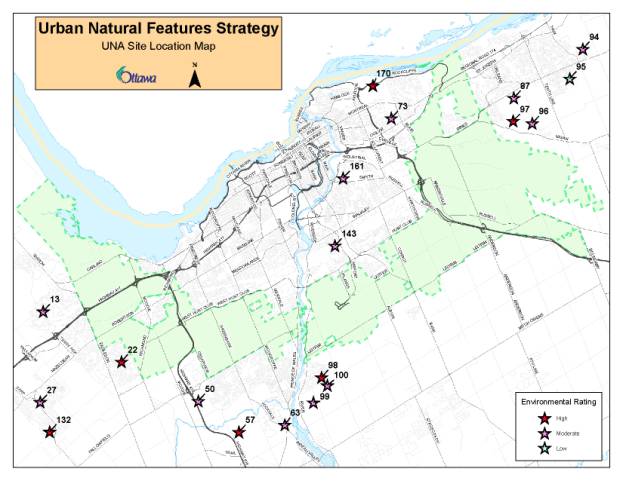
Table 1 lists the 19 priority urban natural areas recommended for protection. The sites that are designated as Urban Natural Features in the Official Plan are shown in bold type. The 19 natural areas total approximately 225 hectares. Total acreage for private sites is approximately 190 hectares. Individual site maps of the 19 priority areas are found in Appendix C of Document 1. There is no intention to designate the priority natural areas for protection until the City acquires the land or an agreement has been reached between the public owner and City on federally-owned lands.
UNA Site # |
Site Name |
City District |
Ward # |
Rating |
Size of Priority Area (ha) |
Securement Timeline |
|
87 |
Innes Park Woods
|
East |
2 |
Moderate |
8.7 |
immediate |
|
96 |
Notre
Dames des Champs Woods |
East |
2 |
Moderate |
10.2 |
medium |
|
97 |
Navan Road at Page Road |
East |
2 |
High |
23.7 |
short |
|
50 |
Highway 416 |
South |
3 |
Moderate |
14 |
medium |
|
57 |
Cambrian Road Woods |
South |
3, 21 |
High |
22 |
medium |
|
13 |
Whalen Park |
West |
4 |
Moderate |
2.2 |
medium |
|
27 |
Poole Creek Corridor |
West |
6 |
Moderate |
2.4 |
medium |
|
132 |
Fernbank Wetland |
West |
6 |
High |
3.7 |
immediate |
|
73 |
NRC Woods South |
Central |
11, 13 |
Moderate |
26.8 |
Federal Site |
|
170 |
NRC Woods North |
Central |
13 |
High |
10.4 |
Federal Site |
|
143 |
CNR Line Woods |
Central |
16 |
Moderate |
19.6 |
Federal Site |
|
161 |
Hospital Woods West |
Central |
18 |
Moderate |
4.8 |
Federal Site |
|
94 |
Cardinal Creek Valley |
East |
1, 19 |
Moderate |
13.2 |
immediate/ medium |
|
95 |
Nantes Street Woods |
East |
19 |
Low |
4.6 |
medium |
|
63 |
Jockvale Road Woods |
South |
22 |
Moderate |
5.9 |
medium |
|
98 |
Riverside South Forest |
South |
22 |
High |
12.8 |
medium |
|
99 |
Spratt Road Woods |
South |
22 |
Moderate |
15 |
medium |
100 |
Armstrong Road South Woods |
South |
22 |
Moderate |
21 |
medium |
|
22 |
Bridlewood Core Park |
West |
23 |
High |
3.4 |
immediate |
It is recommended that the 15 privately-owned priority sites be acquired by the City. Acquisition for the 15 privately-owned sites could be facilitated through such means as purchase (tax base), purchase (special levy), land exchange, or private-public partnership. Appendix D of Document 1 describes various acquisition tools available.
For federal lands, the Greenspace Master Plan states that "The City will endeavour to clarify the greenspace role of undeveloped, publicly-owned land by initiating planning studies on the future use of these lands in partnership with the NCC and other public owners and in consultation with the community and other stakeholders, in order to determine the future greenspace functions of these lands that are now used as open space but are not planned or managed by the owner for that purpose". The four federally-owned priority natural areas would be subject to this policy and process to determine protection potential. Further consultation with affected public owners on the Urban Natural Features Strategy and future planning studies will be undertaken by City staff as directed in the Greenspace Master Plan.
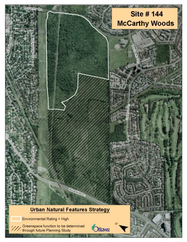
McCarthy
Woods and Southern Corridor (UNA#144)
The UNAEES study of site #144, McCarthy Woods and Southern Corridor, recommended additional study of the ecological relationship between the woodland habitat in McCarthy Woods and the meadow to the west. The UNA boundary to date has included both the woodlands and meadow, while awaiting the results of this additional study.
Two independent wildlife assessment studies undertaken in 2006 by consultants for both the City and the landowner (National Capital Commission) arrived at similar conclusions; that McCarthy Woods proper and the adjacent scrub thicket habitat currently designated as an Urban Natural Feature are important to protect, along with a functional wildlife corridor along the railway tracks. The meadow was not considered to be important habitat. The Urban Natural Area boundary for McCarthy Woods UNA 144 has now been finalized (Document 2) based on this additional technical information, and is currently protected. As per the Greenspace Master Plan direction for federally-owned lands, a future planning study will be the mechanism to determine the greenspace function of the remaining lands.
4800 Bank Street/UNA Site #184 - Remer
Property
In August of 2006, an Information Previously Distributed report (ACS2006-PGM-POL-0040) was prepared updating members of Council on the land negotiations associated with the proposed plan of subdivision for 4800 Bank Street. It was staff’s opinion that the proposed protection area situated at 4800 Bank Street be considered by Planning and Environment Committee as part of the broader Urban Natural Features Strategy and the criteria applied to establish protection priorities.
UNA Site #184, Remer Property rated high for overall environmental value. Based on the strategic directions established in the Strategy, this area is worthy of protection based on its environmental value. However, the planning status of the property also has to be recognized. For this site, a 1991 Ontario Municipal Board (OMB) decision established the Leitrim Provincially Significant Wetland boundary outside of the subdivision lands. The OMB imposed a 120 metre buffer area within the subdivision lands along the wetland edge. The OMB decision on the subdivision lands was carried forward in the Council approved Leitrim Community Design Plan whereby the 120 metre buffer area along the western limit of the subdivision would be protected with the remaining lands within the subdivision supporting urban development.
Based on the CDP and active planning application, the Urban Natural Features Strategy categorizes UNA Site #184 into two categories: Category 1 – Protected Area for the buffer area; and, Category 3 – development approved for the remaining lands within the subdivision. As such, the subdivision lands beyond the buffer area are not being recommended in the Strategy for protection through acquisition.
The land exchange proposal to remove the Remer natural area from the Urban Area and extend the Urban Boundary southward to incorporate an equivalent area, with no net increase in the urban area is not supported. An expansion of the urban boundary for an isolated situation is not in keeping with Official Plan policy whereby designating additional urban land will only be undertaken as part of the five-year assessment of the urban land supply.
Priority
Areas Financial Strategy
Funding requirements based on 2006 land value estimates to acquire the 15 privately-owned natural areas have been provided in the Long Range Financial Plan 3 (LRFP3) budget document. Due to the significant financial resources required to purchase these natural areas, a staged acquisition plan is proposed over a 10-year period. Table 1 – Priority Urban Natural Areas of this report includes a proposed timeline for acquiring the privately-owned sites within the immediate (2007), short (2008) and medium (2009-2016) timeframe.
The potential loss of the natural area to development through pending or in-progress development applications has determined the immediate and short-term acquisition priorities. The remaining natural areas have been placed in the medium-term acquisition horizon; however, the year of purchase for individual sites has not been set. Securement timelines for federally-owned lands have not been identified as these will be determined through future planning studies.
The success of the staged acquisition plan will rely on partnerships and agreement with the affected landowners on the process and acquisition timelines. Most of the privately-owned priority sites are estimated to be within one to five years of development. Acquisition over a 10‑year timeframe implies that some of these sites would be acquired later than their development timeframe. In the case of areas already designated as Urban Natural Features, the Official Plan states that the City will purchase these at the request of the landowner within a six‑month timeline. The Planning, Transit and Environment Department will meet with the affected private landowners to discuss further the Urban Natural Features Strategy, financial options and incentives, and acquisition timelines. Incentives such as tax exemptions on affected private properties could be explored which may assist in lengthening estimated acquisition timelines.
The private sector and federal government have both contributed significantly to the greenspace we currently value and enjoy within the City. A strong commitment by the City to purchase priority natural areas over the next 10 years is needed in order to engage the private and public sector in working together towards achieving our greenspace vision for Ottawa.
ENVIRONMENTAL IMPLICATIONS
The City’s Official Plan and Environmental Strategy recognize the importance of the preservation of natural features, wildlife habitat, ecological function and forests. Among these policies and objectives are:
· Ottawa 20/20 Guiding Principles -Green and Environmentally Sensitive City and a City of Distinct, Liveable Communities
· Environmental Strategy Goals – A Green City and Development in Harmony with the Environment and Clean Air, Water and Earth
· City of Ottawa’s Official Plan – Maintaining Environmental Integrity and Building Liveable Communities
Urban natural areas are an important element of the natural and built landscape. They contribute significantly to public health, community enjoyment, property values, and many areas sustain important environmental features and values. Many natural areas form part of the broader Greenspace Network that contributes to the City's quality of life that is highly valued by its residents. The opportunity exists now to be proactive in our planning to protect natural areas. Acquisition is required to protect important natural areas on private property. If the City does not acquire these natural areas, permitted development will proceed and the natural feature will be lost.
CONSULTATION
Public consultation on the Urban Natural Features Strategy was undertaken in conjunction with the Council-approved Greenspace Master Plan. Public information meetings on the strategic directions and implementation recommendations of the Urban Natural Features Strategy were held in June 2005 at six locations across the city, and again on May 2, 2006 at City Hall. A number of additional meetings with stakeholders and landowners also took place on the development of the Urban Natural Features Strategy, which are summarized below. These discussions led to the development and refinements to the strategy that is before Council in this report.
· Meetings with individual private landowners - meeting took place with Tartan Development, Taggart Realty, Urbandale Corporation, Don Kennedy Consultants, Claridge Homes, Mr. J.P. Chenier, and Mr. P. Harris to discuss planning status, landowner intentions and preliminary implementation recommendations for their affected properties. Urbandale, Claridge, Mr. Chenier and Mr. Harris have properties on the priority acquisition list. Each developer has imminent plans to develop their properties; however, they would consider acquisition by the City.
· Meetings with NCC staff - in 2005 City and NCC staff met to discuss NCC's affected properties in terms of recommended implementation approach. The strategy reflects these discussions recognizing appeals to the Official Plan. City staff met with NCC staff in October 2006 to present the Strategy and the Greenspace Official Plan Amendment.
· Ottawa Carleton Homebuilders' Association - staff met with the OCHBA twice following the June 2005 consultations. The members of the OCHBA stated that the City does not have a good record on acquiring urban natural areas in an expedient fashion. They felt that assurance on availability of acquisition funds, market value assessment and clear process were critical. In addition, the cost incurred in the process of selling the land should be included in the purchase price. City staff will ensure that these issues are incorporated into future discussions.
· Steering Committee and Public Advisory Committee Meetings - the Urban Natural Areas Environmental Evaluation Study established a Steering Committee and Public Advisory Committee for the study. The Steering Committee is represented by various City Department , Ottawa Forests and Greenspace Advisory Committee, Environmental Advisory Committee, the Rideau Valley Conservation Authority, the NCC, and Ministry of Natural Resources. The Public Advisory Committee is represented by a number of community environmental groups including Greenspace Alliance and professional environmental associations. A joint meeting was held on May 10, 2006, to present the Urban Natural Features Strategy to members of the committees. Generally, there is support to acquire priority natural areas in order to protect them.
· Greenspace Alliance of Canada's Capital - City staff attended the April 27, 2006, meeting of the Greenspace Alliance. They provided time on their agenda for City staff to present and discuss the Urban Natural Features Strategy. Although the group generally supported protection of natural features, they could not concur as the detailed implementation recommendations assigned to each UNA site were not provided.
· Environmental and Ottawa Forest and Greenspace Advisory Comittees - City staff attend the March 8, 2007 Environmental Advisory Committee meeting and March 26, 2007 Ottawa Forest and Greenspace Advisory Committee meeting to present the Greenspace Official Plan Amendment and outline the Urban Natural Features Strategy. Both Committees expressed an interest in the forthcoming recommendations of the Urban Natural Features Strategy.
Letters were submitted to the City from National Research Council (NRC) and Ottawa-Carleton Catholic School Board (OCCSB). The NRC has stated that the two priority acquisition areas (UNA #73 and #170) identified in this strategy are not intended for greenspace as they serve the NRC's long-term need for employment lands. As previously discussed, future land use planning studies will be the vehicle to discuss further with federal owners the protection requirements for these lands. The OCCSB requested that the City keep them informed regarding any actions/recommendations proposed for any affected school board properties on or adjacent to a UNA site. Once the priority acquisition list is approved by Council, staff will meet with the OCCSB to discuss further UNA Site #12, Whalen Park, which is listed as a priority site for protection.
At the June 27, 2006, Planning and Environment Committee meeting, Richcraft and Monarch Homes spoke through delegations on the Urban Natural Areas Environmental Evaluation Study Addendum Report and Greenspace Master Plan items. Richcraft stated that they did not feel that UNA #97, Navan Road at Page Road, warranted a high environmental rating based on investigations they have undertaken on the natural area. Richcraft does not feel that UNA #97 priority area should be protected.
Monarch Homes stated at the meeting that they did not feel that UNA #63, Jockvale Road Woods, should have received a moderate rating as their assessment of the natural area would warrant a low rating based on their biologist's opinion. As such, UNA #63 should be removed from the Greenspace Master Plan and the forthcoming Urban Natural Features Strategy. As directed by Committee, City staff and Daniel Brunton met with Monarch representatives on September 14, 2006, to undertake a site visit of UNA #63. An area has been cleared to accommodate a nursery within the natural area. However, the natural area still warrants protection and has been included as a priority area for acquisition although the size of the area to purchase may decrease.
Individual meetings with affected landowners and interested stakeholders will take place once the strategy is approved by Council. The strategy (Document 1) will be made available upon request.
FINANCIAL IMPLICATIONS
Real Property and Asset Management (RPAM) were retained to provide a preliminary land value estimate to purchase the 19 priority natural areas as identified in the Urban Natural Features Strategy. A value estimate of $64,312,000 has been provided to purchase all 19 priority sites based on the status of lands as of May 2006. The value estimate represents the most costly scenario as purchasing the land is assumed as the sole mechanism for securement of the private and publicly-owned priority natural areas. Other financial tools as cited in Appendix D of Document 1 may be used such as land exchange, special levy, public-public partnership and private-public partnership. These securement tools will be further examined by City staff and discussed with affected landowners .
Currently the City has an Environmental Resource Areas Acquisition Fund (#900138) that was established primarily to purchase natural environment areas in the rural area. A status report (ACS2006-PGM-POL-0036) on the environmental acquisition fund was brought forward to Corporate Services and Economic Development Committee and Council for information in June of 2006. Negotiations underway for acquisition of additional lands, both in the urban and rural area, will likely commit most of the existing authority by year-end. Council approved funding in the amount of $350,000 for Rural Feature Acquisition in the 2007 Capital budget. This account will be used to purchase significant natural environment areas in the rural area.
As part of the preparation of the Long Range Financial Plan, only the 15 privately-owned priority natural areas were included. The total cost to purchase the privately-owned priority areas based on the land value estimates prepared by RPAM is approximately $38,090,000. The 2007 LRFP3 identifies the following funding requirements to acquire the 15 privately-owned priority natural features:
2007 - $4,718,000
2008-2016 - $3,708,000 each year extended over a nine-year period based on 2006 values
As part of the 2007 budget process, Council approved the Natural Area Acquisition (Urban) fund in the amount of $4,718,000 (Account #904330). This budget allocation was established based on this strategy and acquisition priorities for 2007 based on potential loss to development through pending or currently in-progress development applications. At the April 11, 2007 meeting, City Council approved the acquisition of the Innes Park Woods (UNA #87) through land exchange and funds in amount of $350,861 (ACS2007-CRMS-RPM-0019). The remaining funds in Account #904330 will be used by the City to seek acquisition of the following priority natural areas this year:
· Portion of the Cardinal Creek Valley, Urban Natural Area #94
· Fernbank Wetland, Urban Natural Area #132
· Bridlewood Core Park, Urban Natural Area #22
The LRFP estimates for 2008 to 2016 will be adjusted as needed in future years to reflect estimated and actual acquisition costs and securement timelines. The remaining priority natural features have been placed in the 2008-2016 timeframe based on an evenly distributed cost over nine years.
The land values are dependent on market forces and are particularly sensitive to changes in the timing of development. Sites identified close to, or in the path of, future development will appreciate in value at a greater rate. Staff will consider the potential implications of changes in land value in setting acquisition priorities. Updated market appraisals will be completed on an annual basis in order to revise the budget forecasts to account for changes in value.
Due to the significant financial resources required to purchase privately-owned natural areas with high urban land values, staff examined the option of protecting only the six designated Urban Natural Features in private ownership and the three high-rated sites (Bridlewood Core Park (UNA #22), Navan Road at Page Road (UNA #97), and Fernbank Wetland (UNA #132)).
The cost to acquire these nine priority sites would be marginally less than purchasing all 15 priority sites as these nine urban natural areas represent approximately 79% of the acquisition value estimate. The relative cost difference over a 10 year period did not appear to be significant enough to warrant eliminating the other six priority private sites from protection and acquisition.
Subject to approval of this report, the recommended funding will be referred to the 2008 budget process. Account #904330, Natural Area Acquisition (Urban) has been established to distinguish between rural environmental lands spending and urban natural features. The urban acquisition account would be used to purchase the priority privately-owned natural areas identified in the Urban Natural Features Strategy only. Should additional funding be required to acquire federal priority sites identified in this strategy, it will be identified through a subsequent Long Range Financial Plan budget process and be subject to Council approval.
SUPPORTING DOCUMENTATION
Document 1 Urban Natural Features Strategy
Document 2 McCarthy Woods Map (UNA #144)
Due to its technical nature, Document 1 is available in English only. The City of Ottawa may translate this document or parts thereof on request. Requests for translation should be forwarded to Susan Murphy (susan.murphy@ottawa.ca) or 613-580-2424, ext. 22518, or to the French Language Services Division at DSF-FLSD@ottawa.ca or 613-580-2424, ext. 21536.
DISPOSITION
Planning, Transit and the Environment Department will meet with affected landowners to discuss further the Urban Natural Features Strategy, financial options and incentives, and acquisition timelines.
Planning, Transit and the Environment Department will direct the Real Estate Services Division to initiate negotiations with property owners associated with the 2007 priority sites.
Since amalgamation in 2001, Council and the community have systematically developed an environmental basis for City decisions on land use and other corporate responsibilities. Under the 20/20 initiative in 2002, the principle of “A green and environmentally sensitive city” was set as one of seven principles to guide the Official Plan, the Environmental Strategy, and other plans to manage the growth projected for Ottawa for the next 20 years. The Official Plan advanced the principle by proposing development of a Greenspace Master Plan to set Council policies for all types of greenspace in Ottawa. Within that framework, the Official Plan also required completion of an Urban Natural Areas Environmental Evaluation Study (UNAEES). The objectives of the study were to identify and to assess the relative environmental value of natural areas across the entire urban area, to establish priorities for protection, and make recommendations for management of these lands.
Muncaster Environmental Planning and Brunton Consulting Services were retained in 2002 to undertake the UNAEES. The key objectives of the study were to:
· Identify all candidate sites of 0.8 ha or larger that were physically present on the landscape at the time of the study, regardless of ownership and approvals in place for future development;
· Assess sites based on fieldwork and supplementary existing data;
· Evaluate sites against nine environmental criteria to rate the environmental value of each site;
· Develop broad management recommendations for passive recreational use and conservation of ecological functions.
The study identified 192 urban natural areas and evaluated 177 of these in two seasons of fieldwork. Of the 177 evaluated sites, 41 were rated as having high environmental value, 67 rated moderate and 69 were rated as low environmental value. Of the remaining 15 sites, four were not evaluated because they had been significantly altered since the initial identification and 11 were not evaluated because of field season limitations (3) or the unwillingness of the landowner to grant permission for the fieldwork (8).
Work on the Urban Natural Areas Environmental Evaluation Study and the Greenspace Master Plan proceeded in parallel through 2003 to 2006. Planning and Environment Committee received a progress report on the UNAEES in January 2005 (ACS2004-DEV-POL-0004). In June of 2005, Council approved the Urban Natural Areas Environmental Evaluation Study, Final Report (ACS2005-PGM-POL-0018). Council's approval of the study methodology, evaluation framework and evaluation criteria established a standard approach to assessing the relative environmental value of urban natural areas in Ottawa. At the same time, a report on the Greenspace Master Plan (ACS2005-PGM-POL-0021) received Planning and Environment Committee’s endorsement on the public consultation details related to several greenspace issues, including implementation of the UNAEES. A broad strategy to implement the UNAEES that included a recommendation to protect high and moderate sites where feasible, was part of this report.
In July 2006 Council approved the
Addendum Report to the UNAEES (ACS2006-PGM-POL-0046), documenting the results
of the sites evaluated in 2005. On
August 23, 2006 Council approved the Greenspace Master Plan
(ACS2006PO2006-PGM-POL-0052). The
Greenspace Master Plan identified the need for Council to adopt an Urban
Natural Features Strategy to prioritize the natural areas remaining in the
urban area that are worthy of protection, and to propose how these areas can be
secured for the long term. This
strategy sets out the City's intentions for protecting a priority list of
natural areas in the urban area to be secured through acquisition or other
means. The adoption of the Urban
Natural Features Strategy allows Council to make decisions on a specific
natural feature based on an understanding of how it fits into the broader
protection and acquisition strategy for urban natural areas.
The Urban Natural Features Strategy provides a systematic approach to establishing priorities for protecting the urban natural areas evaluated through the Urban Natural Areas Environmental Evaluation Study. The strategy consists of the following components:
· Strategic Directions for Protecting Urban Natural Areas
· Categorization of Urban Natural Areas
· Securement Strategy for Urban Natural Areas
The strategic directions and draft implementation recommendations were previously presented at the May 24, 2005 Planning and Environment Committee meeting in the Greenspace Master Plan Public Consultation Details information report (ACS2005-PGM-POL-0021).
Strategic Directions for Protecting Urban Natural Areas
The following strategic directions together are used to identify the priority areas evaluated through the UNAEES that are worthy of protection.
· Protect high and moderate rated sites. These natural areas represent healthy and diverse environmental features that support important ecological functions such as wildlife habitat, and significant species in the urban area. Urban Natural Features currently designated on Schedule B of the Official Plan rated high and moderate environmental value applying the UNAEES evaluation methodology and criteria. Other urban natural areas with a high or moderate environmental rating are also worthy of protection as they meet the definition of Urban Natural Features in the Official Plan.
· Protect natural features in City ownership, including sites with a low environmental value. In keeping with the City’s Official Plan and Environmental Strategy, the City should demonstrate leadership in the protection and enhancement of natural areas held within its corporate assets, where feasible.
· Recognize planning status. Past planning decisions and ongoing planning processes affect many urban natural areas evaluated through the UNAEES, and in some cases the process has progressed to a point where the land is committed for development and protection is not feasible. Planning approvals for a property are therefore factored into the prioritization process.
· Promote environmental stewardship of privately-owned, low-rated sites. Private stewardship of low-rated sites within existing, developed communities is encouraged to help achieve the forest cover targets in the Official Plan.
Categorization of Urban Natural Areas
Through its policies in Section 3.2.3 Urban Natural Features, Council has requested that the Urban Natural Features Strategy identify appropriate methods and priorities for natural area protection, based on the findings of the UNAEES. However, protection of urban natural features is a challenge because protection tools are limited. The responsibility lies with the municipality to create tools for securement if it wants to protect urban natural features that are important to the community. Of all the factors that shape the City’s ability to protect urban natural features, planning approvals for a property have the greatest effect. Past planning decisions and ongoing planning processes affect a number of urban natural areas that may prohibit protection for all or part of these areas. For each property falling in whole or in part within an identified natural area, an assessment of planning status has been undertaken to determine protection opportunities and constraints. OMB decisions, recent Council and planning approvals, Community Design Plans and active development applications were examined to determine if protection opportunities still exist.
Applying
the strategic directions, four categories were established to indicate the
level of protection recommended in the Urban Natural Feature Strategy based on
current land use designation, ownership, and planning approvals. Each of 192 urban natural areas (UNAs) has been
assigned in whole or in part to a category.
Many natural areas have more than one category assigned to it as the
boundary of the UNA encompasses several properties with different ownership and
planning elements. Tables 1-4 contained
in Appendix A of this report contain the lists of UNA sites that fall within
each of the following four categories. The city-wide Urban Natural Features
Strategy map illustrates the applicable categories assigned to each urban
natural area (distributed under separate cover).
· Category 1 – Protected Urban Natural Areas
· Category 2 – New Urban Natural Areas – Securement by City Required
· Category 3 – Development Approved
· Category 4 - Environmental Evaluation Outstanding
For each category, further actions to provide appropriate protection are recommended.
Category 1 – Protected Urban Natural Areas
The protected Urban Natural Areas category consists of three sub-groups: 1) Designated Urban Natural Features; 2) Areas to be designated and zoned as Urban Natural Features, supported by the landowner; and, 3) Promote protection of the urban natural area through stewardship. Each sub-group and required action is described in the following sections. The list of sites in Category 1 is found in Table 1, Appendix A.
Group 1A - Currently Designated and Zoned as Urban Natural Features
Action: No land use planning
requirements
Lands in Category 1A include all high, moderate, and publicly-owned low-rated sites that are currently designated Urban Natural Features or Significant Wetland on Schedule B of the Official Plan. No further action in terms of amendments to the City’s Official Plan is required. All designated Urban Natural Features are being zoned for environmental protection through the City's Comprehensive Zoning Bylaw. There are currently 76 natural areas that are already designated Urban Natural Features on Schedule B of the Official Plan. There are six Urban Natural Features designations in private ownership that require acquisition as per Section 5.2.1 of the Official Plan.
The Council approved Greenspace Master Plan (June 2006) states that "The City will manage City-owned lands in a manner that is consistent with the long-term maintenance of greenspace values identified in the Urban Natural Environmental Evaluation Study by preparing management plans and policies for City-owned natural lands that focus on the protection of environmental features and functions while accommodating public access and leisure activities where appropriate". The development and implementation of management plans for City-owned Urban Natural Features will be undertaken as set out in the Greenspace Master Plan. Work programs and priorities will be integrated into the budgetary process through existing programs.
Group 1B – Areas to be Designated and Zoned as Urban Natural Features,
Supported by Landowner
Action: Official Plan and
Zoning Amendments to Urban Natural Features
Lands in Group 1B are mainly high and moderate-rated sites where the landowner is in agreement with a redesignation and rezoning of the land to Urban Natural Features. Most of these lands are already designated or recognized as major open space or parkland. Lands in Group 1B include lands designated Major Open Space and General Urban Area that are owned by the City or National Capital Commission (NCC) where there is agreement to protect the natural areas as part of the current or planned use of the land. This category also includes privately-owned urban natural areas that contain creek corridors. Through the development approval process, these lands will be zoned and conveyed to the City for conservation purposes.
There are a total of 40 natural areas that will be redesignated to Urban Natural Feature. Eight areas are expansions to existing Urban Natural Features, while 32 areas represent new Urban Natural Features.
Category 1B lands have been included in the forthcoming greenspace Official Plan Amendment involving public lands only where landowner agreement has been obtained to redesignate their lands, at no cost to the City.
Group 1C – Promote Protection of Urban Natural Area through Stewardship
Action: Stewardship and appropriate management required.
Lands in Group 1C include low-rated sites or small portions of a high or moderate rated site in both public and private ownership that currently are not designated Urban Natural Features on Schedule B of the Official Plan. However, protection of the natural area is considered feasible as it is present within an existing, built community. Protection and conservation of the natural area through management and stewardship activities is recommended. Lands in this category are generally:
· low-rated sites situated in City parks that are designated General Urban Area, where protection of the natural feature is compatible with the current or future park program. The site will be managed to conserve the environmental value of the natural feature.
· publicly-owned lands that are designated Major Open Space where protection of the natural feature is compatible with the existing use or park program.
· other public and privately-owned lands that include a portion of a moderate or low-rated site where the retention of the natural feature may be compatible as it is situated in an existing, built development and/or constraint lands. Examples include privately-owned creek or river shorelines, floodplain lands, escarpment lands, and public utility corridors.
Public and private stewardship will be the main protection mechanism for these sites.
Category 2 – New Urban Natural Features Securement by City Required
Action: Designate and zone new Urban Natural Features when acquired or
agreement reached on federal property
This category includes all, or a portion of, the high or moderate-rated urban natural areas recommended for protection that are currently not designated Urban Natural Features on Schedule B of the Official Plan. A total of 13 urban natural areas have been identified as worthy of protection. Category 2 includes nine privately-owned sites and four federally-owned sites. It is recommended that City acquire the nine privately-owned natural areas. The planning status of the properties still enables the City to protect the natural feature through acquisition. Acquisition could be facilitated through such means as purchase from general tax base, land exchange, private-public partnership, public-public partnership or local improvements. Category 2 sites are listed in Table 2 of Appendix A.
Of the 13 urban natural features identified, a total of four sites rated as high and 9 as moderate for environmental value. For the federal sites, one site rated high and three sites rated moderate for environmental value. As stated in the Greenspace Master Plan, the City will initiate planning studies on undeveloped, publicly-owned lands in partnership with the NCC and other public bodies in order to determine the future greenspace functions of these lands. As such, the protection requirements for the four federal sites will be determined through subsequent planning studies.
There is no intention to designate the priority natural areas for protection until the City acquires the land or an agreement has been reached between the public owner and City on federal lands. Once a natural area is secured by the City, an amendment to Schedule B of the Official Plan designating the area as Urban Natural Features, and corresponding Zoning Bylaw Amendment, will be brought forward. The acquisition of individual sites will be subject to Council approval.
Category 3 - Development Approved
Action: Full protection not being pursued, address through planning
process
This category includes all or portions of high-rated or moderate-rated natural areas where recent planning approvals prevent full protection of the feature. In these cases, planning approvals have progressed to the point where the land is committed for development and protection is not feasible.
Planning approvals include OMB decisions, Council and planning approvals on public and private property, commitments made in approved community design plans, and active development applications.
A total of 89 sites, in whole or in part, fall within this category. This includes a total of 28 privately-owned sites that were rated as having low environmental value. These low-rated sites are not recommended for protection through acquisition, in keeping with the strategic directions for protecting urban natural areas. The four sites that were investigated in 2006 all received an overall environmental rating of low and are included in this category. For sites still subject to development approval, tree preservation and conservation opportunities will be encouraged as part of any development review process, at no cost to the City.
This category also includes City-owned land where corporate commitments such as parkland development prevent full protection of the natural feature. Integration and conservation opportunities for partial protection of natural features will be considered as part of the development planning.
Sites in Category 3 are listed in Table 3 of Appendix A.
Category 4 - Environmental Evaluation Outstanding
There are four sites that have not been evaluated applying the UNAEES criteria, as listed in Table 4 of Appendix A. The landowner has denied permission to access their private property as requested by the City in 2003 and 2005. Recent planning approvals have not occurred for the lands containing the urban natural area. As such, an Environmental Impact Statement will be required at the time of development review to determine the environmental value of these sites and to inform future decisions.
Securement Strategy for Priority Urban Natural Areas
Based on the environmental value determined through the UNAEES and the strategic directions described above, 19 urban natural areas are recommended for securement, including four natural areas in federal ownership and 15 natural areas in private ownership. Of the 19 sites, 13 are new urban natural features not designated in the Official Plan drawn from Category 2 above, that still have an opportunity to be protected if the City secures them. In addition, six natural areas in private ownership are already designated Urban Natural Features on Schedule B of the City's Official Plan (Category 1). Based on the Official Plan acquisition policy, the City is required to purchase designated Urban Natural Features in private ownership when requested to do so by the owner (see Appendix B).
Tables 1 list the 19 priority urban natural areas recommended for protection. The sites designated as Urban Natural Features in the Official Plan are shown in bold type. The 19 natural areas total approximately 225 hectares. Total acreage for private sites is approximately 190 hectares. Individual site maps of the 19 priority areas are found in Appendix C.
Table 1 – Priority Urban
Natural Areas
UNA Site # |
Site Name |
City District |
Ward # |
Rating |
Size of Priority Area (ha) |
Securement Timeline |
|
87 |
Innes Park Woods |
East |
2 |
Moderate |
8,7 |
immediate |
|
96 |
Notre
Dames des Champs Woods |
East |
2 |
Moderate |
10.2 |
medium |
|
97 |
East |
2 |
High |
23.7 |
short |
|
|
50 |
Highway 416 |
South |
3 |
Moderate |
14 |
medium |
|
57 |
Cambrian Road Woods |
South |
3, 21 |
High |
22 |
medium |
|
13 |
Whalen Park |
West |
4 |
Moderate |
2.2 |
medium |
|
27 |
Poole Creek Corridor |
West |
6 |
Moderate |
2.4 |
medium |
|
132 |
Fernbank Wetland |
West |
6 |
High |
3.7 |
immediate |
|
73 |
NRC Woods South |
Central |
11, 13 |
Moderate |
26.8 |
Federal Site |
|
170 |
NRC Woods North |
Central |
13 |
High |
10.4 |
Federal Site |
|
143 |
CNR Line Woods |
Central |
16 |
Moderate |
19.6 |
Federal Site |
|
161 |
Hospital Woods West |
Central |
18 |
Moderate |
4.8 |
Federal Site |
|
94 |
Cardinal Creek Valley |
East |
1, 19 |
Moderate |
13.2 |
immediate/ medium |
|
95 |
Nantes Street Woods |
East |
19 |
Low |
4.6 |
medium |
|
63 |
Jockvale Road Woods |
South |
22 |
Moderate |
5.9 |
medium |
|
98 |
Riverside South Forest |
South |
22 |
High |
12.8 |
medium |
|
99 |
Spratt Road Woods |
South |
22 |
Moderate |
15 |
medium |
100 |
Armstrong Road South Woods |
South |
22 |
Moderate |
21 |
medium |
|
22 |
Bridlewood Core Park |
West |
23 |
High |
3.4 |
immediate |
It is recommended that the City acquire the 15 privately-owned priority sites. Acquisition for the 15 privately-owned sites could be facilitated through such means as purchase (tax base), purchase (special levy), land exchange, or private-public partnership. Appendix D describes various acquisition tools available.
For federal lands, the Greenspace Master Plan states that "The City will endeavour to clarify the greenspace role of undeveloped, publicly-owned land by initiating planning studies on the future use of these lands in partnership with the NCC and other public owners and in consultation with the community and other stakeholders, in order to determine the future greenspace functions of these lands that are now used as open space but are not planned or managed by the owner for that purpose". The four federally-owned priority natural areas would be subject to this policy and process to determine protection potential. Further consultation with affected public owners on the Urban Natural Features Strategy and future planning studies will be undertaken by City staff as directed in the Greenspace Master Plan.
There is no intention to designate the priority natural areas for protection until the City acquires the land or an agreement has been reached between the public owner and City on federally-owned lands.
Funding requirements based on 2006 land value estimates to acquire the 15 privately-owned natural areas have been provided in the Long Range Financial Plan 3 (LRFP3) budget document that was tabled with Council in November 2006. Due to the significant financial resources required to purchase these natural areas, a staged acquisition plan is proposed over a 10-year period. Table 1 – Priority Urban Natural Areas above includes a proposed timeline for acquiring the privately-owned sites within the immediate (2007), short (2008) and medium (2009-2016) timeframe. The potential loss of the natural area to development through pending or in progress development applications has determined the immediate and short-term acquisition priorities. The remaining natural areas have been placed in the medium term acquisition horizon; however, the year of purchase for individual sites has not been set. Securement timelines for federally-owned lands have not been identified, as these will be determined through future planning studies.
The success of the staged acquisition plan will rely on partnerships and agreement with the affected landowners on the process and acquisition timelines. Most of the privately-owned priority sites are estimated to be within one to five years of development. Acquisition over a 10‑year timeframe implies that some of these sites would be acquired later than their development timeframe. In the case of areas already designated as Urban Natural Features, the Official Plan states that the City will purchase these at the request of the landowner within a six‑month timeline. Planning, Transit and Environment Department will meet with the affected private landowners to discuss further the Urban Natural Features Strategy, financial options, incentives, and acquisition timelines. Incentives such as tax exemptions on affected private properties could be explored which may assist in lengthening acquisition timelines
APPENDIX A – CATEGORY TABLES
TABLE 1: CATEGORY 1 SITES PROTECTED URBAN NATURAL AREAS
|
UNA Name |
Site Number |
Sub-Area |
Ward # |
Overall Rating |
Ownership |
UNFS Category |
Other UNFS Category |
|
Trillium Woods |
1 |
West |
4 |
High |
Private, City |
1 |
3 |
|
Marchwood/Lakeside NEA A |
2 |
West |
4 |
High |
Private |
1 |
3 |
|
Cunningham Woods |
7 |
Central |
18 |
Low |
City |
1 |
n/a |
|
Klondike Road Park |
9 |
West |
4 |
Low |
City |
1 |
n/a |
|
Morgan's Grant Woods |
10 |
West |
4 |
Moderate |
City |
1 |
n/a |
|
Alice Wilson Woods |
12 |
West |
4 |
Moderate |
City |
1 |
n/a |
|
Whalen Park |
13 |
West |
4 |
Moderate |
City, Private |
1 |
2 |
|
Young's Pond Park |
15 |
West |
23 |
Low |
City |
1 |
n/a |
|
Hazeldean Woods Park |
17 |
West |
23 |
High |
City |
1 |
3 |
|
Hewitt Park Woods |
18 |
West |
23 |
Low |
City |
1 |
n/a |
|
Katimivik Park Woods |
19 |
West |
23 |
Moderate |
City |
1 |
n/a |
|
Cattail Creek Park Woods |
20 |
West |
23 |
Low |
City |
1 |
n/a |
|
Escarpment Park Woods |
21 |
West |
23 |
Low |
City |
1 |
n/a |
|
Hope Cloutier Park |
24 |
West |
23 |
Low |
City |
1 |
n/a |
|
Stittsville Arena Park |
26 |
West |
6 |
Moderate |
City, Private |
1 |
3 |
|
Poole Creek Corridor |
27 |
West |
6 |
Moderate |
City, Private |
1 |
2 & 3 |
|
Upper Poole Creek Wetland |
28 |
West |
6 |
High |
City, Private |
1 |
3 |
|
Lower Poole Creek Corridor |
30 |
West |
6 |
Moderate |
City |
1 |
n/a |
|
Bell Memorial Park |
31 |
West |
6 |
Moderate |
City |
1 |
n/a |
|
Palladium Interchange |
33 |
West |
4 |
Evaluation Outstanding |
Private |
1 |
3 |
|
Lower Stillwater Creek |
34 |
Central |
7 |
High |
City, Private |
1 |
n/a |
|
Ottawa Beach |
35 |
Central |
7 |
High |
City |
1 |
n/a |
|
Monterey Ravine |
36 |
Central |
8 |
Moderate |
City, Private |
1 |
3 |
|
Leslie Park Woods |
37 |
Central |
8 |
Low |
City, Private |
1 |
n/a |
|
Arlington Woods Park |
38 |
Central |
9 |
Moderate |
City, Public Utility |
1 |
3 |
|
Tallwood Woods |
40 |
Central |
8 |
Moderate |
City |
1 |
3 |
|
Manordale Woods |
41 |
Central |
9 |
Low |
City |
1 |
n/a |
|
Tanglewood Park |
43 |
Central |
9 |
Low |
City |
1 |
n/a |
|
Nepean Creek Corridor |
44 |
Central |
9 |
Moderate |
Federal, Private |
1 |
3 |
|
Pine Glen Park |
46 |
Central |
9 |
Moderate |
City |
1 |
n/a |
|
Barrhaven Escarpment Park |
47 |
South |
3 |
Low |
City, Private |
1 |
n/a |
|
South Nepean Park |
48 |
South |
3 |
Low |
City |
1 |
3 |
|
Half Moon Bay Park |
49 |
South |
3 |
Moderate |
City |
1 |
n/a |
|
Riverstone Shore |
54 |
South |
22 |
Moderate |
City, Private |
1 |
n/a |
|
Rideau Glen Ravine |
55 |
South |
22 |
Moderate |
City, |
1 |
n/a |
|
Jock River Conservation
Area |
56 |
South |
3 |
Low |
City |
1 |
n/a |
|
Cambrian Road Woods |
57 |
South |
3, 21 |
High |
Private |
1 |
3 |
|
Memorial Gardens Woods |
58 |
South |
22 |
High |
City |
1 |
n/a |
|
Jock River Landing |
59 |
South |
21,22 |
Moderate |
City, Private |
1 |
3 |
|
Chapman Mills - West
Woodlot |
60 |
South |
22 |
Moderate |
Private |
1 |
n/a |
|
Chapman Mills - East
Woodlot |
61 |
South |
22 |
Moderate |
Private |
1 |
n/a |
|
Sach's Forest |
62 |
South |
22 |
Moderate |
City |
1 |
n/a |
|
Rockcliffe Parkway |
66 |
Central |
11, 13 |
Moderate |
Federal |
1 |
n/a |
|
Aviation Parkway North |
67 |
Central |
11 |
Moderate |
City, Federal |
1 |
3 |
|
Aviation Parkway South |
68 |
Central |
11 |
Low |
Private, City |
1 |
3 |
|
Queensway Park |
69 |
Central |
11 |
Low |
City |
1 |
n/a |
|
Kindlecourt Park |
70 |
Central |
11 |
Moderate |
Private, City |
1 |
3 |
|
Ski Hill Park |
71 |
Central |
11 |
Moderate |
City |
1 |
n/a |
|
Rothwell Heights Park |
72 |
Central |
11 |
Low |
Private |
1 |
n/a |
|
Upper Duck Island |
75 |
Central |
11 |
High |
City |
1 |
n/a |
|
Centre Park |
76 |
East |
2 |
Low |
City |
1 |
n/a |
|
By-Pass Woods |
77 |
East |
2 |
High |
Federal |
1 |
n/a |
|
Church Woods at Innes |
78 |
East |
2 |
Moderate |
City |
1 |
3 |
|
Rachette Park |
81 |
East |
2 |
Low |
City, Private |
1 |
3 |
|
Forestglen Park |
82 |
East |
2 |
High |
City |
1 |
n/a |
|
Chapel Hill Park |
83 |
East |
2 |
High |
City |
1 |
n/a |
|
Louis Perrault Park |
84 |
East |
2 |
Moderate |
City, Private |
1 |
3 |
|
Bilberry Creek Valley |
85 |
East |
1, 2, 19 |
High |
City |
1 |
n/a |
|
Carriere Park |
86 |
East |
2 |
Low |
City |
1 |
n/a |
|
Innes Park Woods |
87 |
East |
2 |
Moderate |
Private |
1 |
3 |
|
St. Joseph Blvd. Woods |
88 |
East |
1 |
Moderate |
City, Private |
1 |
3 |
|
Terry Fox School Woods |
89 |
East |
1 |
Low |
City |
1 |
n/a |
|
Lower Bilberry Creek Valley |
90 |
East |
1 |
Moderate |
City |
1 |
3 |
|
Quarry Woods East |
91 |
East |
1 |
Moderate |
Private |
1 |
n/a |
|
Petrie Island &
Mainland |
92 |
East |
1, 19 |
High |
City, Prov., Private |
1 |
3 |
|
Taylor Creek Valley |
93 |
East |
1 |
Moderate |
City, Private |
1 |
3 |
|
Cardinal Creek Valley |
94 |
East |
1, 19 |
Moderate |
Private, City |
1 |
2 |
|
Nantes Street Woods |
95 |
East |
19 |
Low |
City, Private |
1 |
3 |
|
Riverside South Forest |
98 |
South |
22 |
High |
Private |
1 |
n/a |
|
Spratt Road Woods |
99 |
South |
22 |
Moderate |
Private |
1 |
n/a |
|
Armstrong Road South Woods |
100 |
South |
22 |
Moderate |
Private |
1 |
3 |
|
Mosquito Creek Corridor |
101 |
South |
22 |
Moderate |
Private |
1 |
n/a |
|
Canyon Walk Woods |
104 |
South |
22 |
Low |
City, Private |
1 |
n/a |
|
Del Zotto Woods |
105 |
South |
22 |
Low |
Federal |
1 |
n/a |
|
CLC lands at Lester |
109 |
Central |
22 |
site altered |
Federal, Private |
1 |
3 |
|
Sawmill Creek Community
Centre Woods |
110 |
Central |
22 |
Low |
City |
1 |
n/a |
|
Mosquito Creek Valley at
Limebank |
112 |
Central |
22 |
Moderate |
Private |
1 |
3 |
|
Upper Mosquito Creek |
113 |
Central |
22 |
Moderate |
Private |
1 |
3 |
|
Wolf Point Woods |
114 |
Central |
22 |
Low |
City |
1 |
n/a |
|
Britannia Bay |
115 |
Central |
7 |
High |
City, Federal |
1 |
n/a |
|
Britannia Conservation Area |
116 |
Central |
7 |
High |
Federal, City |
1 |
n/a |
|
Elmhurst Park Woods |
117 |
Central |
7 |
High |
City |
1 |
n/a |
|
Pinecrest Woods |
119 |
Central |
7 |
Low |
Federal |
1 |
n/a |
|
Des Chenes Lookout |
120 |
Central |
7 |
High |
Federal |
1 |
n/a |
|
Carlington Woods |
121 |
Central |
7 |
Moderate |
Federal, City, Private |
1 |
3 |
|
Hampton Park Woods |
122 |
Central |
15 |
High |
Federal, City |
1 |
n/a |
|
Riverside Park Woods |
123 |
Central |
15 |
Low |
Federal, City |
1 |
n/a |
|
Champlain Bridge Woods |
124 |
Central |
15 |
Moderate |
Federal |
1 |
n/a |
|
Champlain Bridge Islands |
125 |
Central |
15 |
High |
Federal |
1 |
n/a |
|
Riverside Park |
126 |
Central |
15 |
Moderate |
Federal |
1 |
n/a |
|
Chaudiere Rapids |
127 |
Central |
15 |
Low |
Federal |
1 |
n/a |
|
Lemieux Island |
128 |
Central |
15 |
High |
Federal, City |
1 |
3 |
|
Brown's Inlet |
129 |
Central |
17 |
Low |
City, Private |
1 |
n/a |
|
Central Experimental Farm
Woods |
130 |
Central |
16 |
Low |
Federal |
1 |
n/a |
|
Fernbank Wetland |
132 |
West |
6 |
High |
Private |
1 |
2 & 3 |
|
Arboretum Woods |
133 |
Central |
16 |
Low |
Federal |
1 |
n/a |
|
Hog's Back Woods |
134 |
Central |
16 |
Moderate |
Federal, Private |
1 |
n/a |
|
Prince of Wales Woods |
135 |
Central |
16 |
Moderate |
Federal, City |
1 |
n/a |
|
Vincent Massey Woods |
136 |
Central |
16 |
High |
Federal |
1 |
n/a |
|
Rideau River Islands |
137 |
Central |
17 |
High |
Federal |
1 |
n/a |
|
RA Centre Woods |
138 |
Central |
17 |
Low |
Federal |
1 |
n/a |
|
Hog's Back Woods - East |
139 |
Central |
16 |
Moderate |
Federal |
1 |
3 |
|
Leopold Woodlot |
140 |
Central |
16 |
Moderate |
Federal, Private |
1 |
n/a |
|
Sawmill Creek Woods |
141 |
Central |
17, 18 |
Moderate |
City |
1 |
n/a |
|
Mid-Sawmill Creek Corridor |
142 |
Central |
16, 17 |
Moderate |
City |
1 |
n/a |
|
McCarthy Woods and Southern
Corridor |
144 |
Central |
16 |
High |
Federal |
1 |
n/a |
|
Paul Landry Park Woods |
146 |
Central |
16 |
Low |
City |
1 |
n/a |
|
Riverwood Park Woods |
147 |
Central |
16 |
Moderate |
City |
1 |
n/a |
|
River Road Woods |
148 |
Central |
10, 16 |
High |
City, Private |
1 |
3 |
|
Mountain Crescent Woods |
149 |
Central |
10 |
Low |
City, Private |
1 |
3 |
|
Conroy Swamp/ Greenboro
Turtlehead Nature Area |
151 |
Central |
10 |
High |
City, Private |
1 |
3 |
|
Conroy Woods |
152 |
Central |
10 |
Low |
City, Private |
1 |
3 |
|
Heatherington Road Woods |
153 |
Central |
10 |
Low |
City |
1 |
n/a |
|
Jim Durrell Woods |
154 |
Central |
18 |
Low |
City |
1 |
n/a |
|
Pleasant Park Woods |
159 |
Central |
18 |
High |
City |
1 |
n/a |
|
Lynda Lane Woods |
160 |
Central |
18 |
Low |
City |
1 |
n/a |
|
Rideau River Park Woods |
162 |
Central |
17 |
Moderate |
Federal |
1 |
n/a |
|
Coronation Park |
163 |
Central |
18 |
Moderate |
City |
1 |
n/a |
|
Eastway Gardens Woods |
164 |
Central |
18 |
Low |
Provincial |
3 |
n/a |
|
Hospital Woods - East |
165 |
Central |
18 |
Moderate |
City, Private |
1 |
3 |
|
Presland Park Woods |
166 |
Central |
13 |
Low |
City |
1 |
n/a |
|
Rockcliffe Park West |
168 |
Central |
13 |
High |
Federal |
1 |
n/a |
|
Airbase Woods |
169 |
Central |
13 |
High |
Federal, Private |
1 |
n/a |
|
NRC Woods North |
170 |
Central |
13 |
High |
Federal |
1 |
2 |
|
Montfort Woods |
171 |
Central |
13 |
Moderate |
Federal, Private |
1 |
3 |
|
Assaly Woods |
172 |
Central |
13 |
Low |
Private |
1 |
n/a |
|
Bathgate Park Woods |
174 |
Central |
13 |
Low |
City, Private |
1 |
3 |
|
Richelieu Park |
175 |
Central |
12 |
Moderate |
City |
1 |
n/a |
|
McKay Lake |
176 |
Central |
13 |
Moderate |
City |
1 |
n/a |
|
Rockcliffe Park East |
177 |
Central |
13 |
Moderate |
Federal |
1 |
n/a |
|
Nivens Woods |
178 |
Central |
11 |
Moderate |
City, Private |
1 |
n/a |
|
Billberry Park Woods |
180 |
East |
1 |
Moderate |
City |
1 |
n/a |
|
Parliament Hill |
181 |
Central |
14 |
Low |
Federal |
1 |
n/a |
|
Abbott/Iber Woodlot |
182 |
West |
6 |
Low |
City |
1 |
n/a |
|
Heart's Desire Forest |
183 |
South |
22 |
High |
City |
1 |
n/a |
|
Remer Property (Albion
Wetland) |
184 |
South |
20, 22 |
High |
Private |
1 |
3 |
|
Poole Creek North |
185 |
West |
6 |
Moderate |
City, Private |
1 |
3 |
|
St. Louis Woods |
187 |
East |
1 |
High |
City, Private |
1 |
n/a |
|
Petrie West |
188 |
East |
1 |
High |
City |
1 |
n/a |
|
Rockcliffe Shores |
189 |
Central |
13 |
Low |
Federal |
1 |
n/a |
|
North Sawmill Creek Park |
190 |
Central |
10 |
Low |
City |
1 |
n/a |
|
Hiawatha Park Ravine |
191 |
East |
1 |
Moderate |
City |
1 |
3 |
TABLE 2: CATEGORY 2 SITES –
NEW URBAN NATURAL AREAS, SECUREMENT BY THE CITY REQUIRED
|
UNA Name |
Site Number |
Sub-Area |
Ward # |
Overall Rating |
Ownership |
UNFS Category |
Other UNFS Category |
|
Notre-Dames des Champs Woods |
96 |
East |
2 |
Moderate |
City, Private |
2 |
3 |
|
Navan Road at Page Road |
97 |
East |
2 |
High |
Private |
2 |
3 |
|
Highway 416 |
50 |
South |
3 |
Moderate |
Private |
2 |
- |
|
Whalen Park |
13 |
West |
4 |
Moderate |
City, Private |
2 |
1 |
|
Poole Creek Corridor |
27 |
West |
6 |
Moderate |
City, Private |
2 |
1 & 3 |
|
Fernbank Wetland |
132 |
West |
6 |
High |
Private |
2 |
1 & 3 |
|
NRC Woods North |
170 |
Central |
13 |
High |
Federal |
2 |
1 |
|
CNR Line |
143 |
Central |
16 |
Moderate |
Federal, City |
2 |
- |
|
Hospital Woods - West |
161 |
Central |
18 |
Moderate |
Federal, Private |
2 |
- |
|
Jockvale Road Woods |
63 |
South |
22 |
Moderate |
Private |
2 |
3 |
|
Bridlewood Core Park |
22 |
West |
23 |
High |
Private, City |
2 |
3 |
|
Cardinal Creek Valley |
94 |
East |
1, 19 |
Moderate |
Private, City |
2 |
1 |
|
NRC Woods South |
73 |
Central |
11, 13 |
Moderate |
Federal |
2 |
- |
TABLE 3: CATEGORY 3 SITES – DEVELOPMENT APPROVED
|
UNA Name |
Site Number |
Sub-Area |
Ward # |
Overall Rating |
Ownership |
UNFS Category |
Other UNFS Category |
|
Trillium Woods |
1 |
West |
4 |
High |
City, Private |
3 |
1 |
|
Marchwood/Lakeside NEA A |
2 |
West |
4 |
High |
Private |
3 |
1 |
|
South Richardson Lands |
3 |
West |
4 |
High |
Private |
3 |
- |
|
Klondike Woods |
4 |
West |
4,5 |
Evaluation Outstanding |
Private |
3 |
4 |
|
Shirley's Brook Corridor |
5 |
West |
4 |
Evaluation Outstanding |
Private |
3 |
4 |
|
Fourth Line Woods |
6 |
West |
4 |
site altered |
Private |
3 |
- |
|
Banchory Woods |
8 |
West |
4 |
Low |
Private |
3 |
- |
|
Kanata Town Centre Core
Park |
14 |
West |
4 |
High |
Private, City |
3 |
- |
|
Kanata South Business Park |
16 |
West |
23 |
Moderate |
Private |
3 |
- |
|
Hazeldean Woods Park |
17 |
West |
23 |
High |
City |
3 |
1 |
|
Bridlewood Core Park |
22 |
West |
23 |
High |
Private, City |
3 |
2 |
|
Judy Laughton Park |
23 |
West |
4 |
Moderate |
City |
3 |
- |
|
Stonemeadow Park |
25 |
West |
23 |
Moderate |
Private |
3 |
- |
|
Stittsville Arena Park |
26 |
West |
6 |
Moderate |
City, Private |
3 |
1 |
|
Poole Creek Corridor |
27 |
West |
6 |
Moderate |
City, Private |
3 |
1 & 2 |
|
Upper Poole Creek Wetland |
28 |
West |
6 |
High |
City, Private |
3 |
1 |
|
North of Hazeldean |
29 |
West |
6 |
Evaluation Outstanding |
Private |
3 |
4 |
|
North of Maple Grove |
32 |
West |
6 |
Moderate |
Private |
3 |
- |
|
Palladium Interchange |
33 |
West |
4 |
Evaluation Outstanding |
Private |
3 |
1 |
|
Monterey Ravine |
36 |
Central |
8 |
Moderate |
City, Private |
3 |
1 |
|
Arlington Woods Park |
38 |
Central |
9 |
Moderate |
City, Public Utility |
3 |
1 |
|
Gilbey Park |
39 |
Central |
9 |
Low |
City, Private |
3 |
- |
|
Tallwood Woods |
40 |
Central |
8 |
Moderate |
City |
3 |
1 |
|
Pinecrest Cemetery |
42 |
Central |
8 |
Low |
Private |
3 |
- |
|
Nepean Creek Corridor |
44 |
Central |
9 |
Moderate |
Federal, Private |
3 |
1 |
|
West Hunt Club |
45 |
Central |
9 |
Low |
Private |
3 |
- |
|
South Nepean Park |
48 |
South |
3 |
Low |
City |
1 |
3 |
|
Strandherd Woodlot |
51 |
South |
3 |
Low |
Private |
3 |
- |
|
Cedarview Woodlot |
52 |
South |
3 |
Low |
Private |
3 |
- |
|
Strandherd at Fallowfield |
53 |
South |
3 |
Low |
Private |
3 |
- |
|
Cambrian Road Woods |
57 |
South |
3, 21 |
High |
Private |
3 |
1 |
|
Jock River Landing |
59 |
South |
21, 22 |
Moderate |
City, Private |
3 |
1 |
|
Jockvale Road Woods |
63 |
South |
22 |
Moderate |
Private |
3 |
2 |
|
Stonebridge Golf Club |
64 |
South |
22 |
Low |
Private |
3 |
- |
|
Deerfox at Woodroffe |
65 |
South |
3 |
site altered |
Private |
3 |
- |
|
Aviation Parkway North |
67 |
Central |
11 |
Moderate |
City, Federal |
3 |
1 |
|
Aviation Parkway South |
68 |
Central |
11 |
Low |
Private, City |
3 |
1 |
|
Kindlecourt Park |
70 |
Central |
11 |
Moderate |
Private, City |
3 |
1 |
|
City Park Woods |
74 |
Central |
11 |
Low |
Private |
3 |
- |
|
Church Woods at Innes |
78 |
East |
2 |
Moderate |
City |
3 |
1 |
|
Lafarge 1 |
79 |
East |
2 |
Evaluation Outstanding |
Private |
3 |
- |
|
Lafarge 2 |
80 |
East |
2 |
Evaluation Outstanding |
Private |
3 |
- |
|
Rachette Park |
81 |
East |
2 |
Low |
City, Private |
3 |
1 |
|
Louis Perrault Park |
84 |
East |
2 |
Moderate |
City, Private |
3 |
1 |
|
Innes Park Woods |
87 |
East |
2 |
Moderate |
Private |
3 |
1 |
|
St. Joseph Blvd. Woods |
88 |
East |
1 |
Moderate |
City, Private |
3 |
1 |
|
Lower Bilberry Creek Valley |
90 |
East |
1 |
Moderate |
City |
3 |
1 |
|
Petrie Island & Mainland |
92 |
East |
1, 19 |
High |
City, Prov., Private |
3 |
1 |
|
Taylor Creek Valley |
93 |
East |
1 |
Moderate |
City, Private |
3 |
1 |
|
Nantes Street Woods |
95 |
East |
19 |
Low |
City, Private |
3 |
1 |
|
Notre-Dames des Champs Woods |
96 |
East |
2 |
Moderate |
City, Private |
3 |
2 |
|
Navan Road at Page Road |
97 |
East |
2 |
High |
Private |
3 |
2 |
|
Armstrong Road South Woods |
100 |
South |
22 |
Moderate |
Private |
3 |
1 |
|
Leitrim at Limebank |
102 |
South |
22 |
Low |
Federal |
3 |
- |
|
East of Limebank, North of
Armstrong |
103 |
South |
22 |
Low |
Private |
3 |
- |
|
East of Albion Road |
106 |
South |
22 |
Evaluation Outstanding |
City, Private |
3 |
- |
|
East of Albion Road |
106 |
South |
22 |
Low |
City, Private |
3 |
- |
|
Albion Industrial Park |
107 |
South |
22 |
Low |
Private |
3 |
- |
|
Finlay Creek Woodlot |
108 |
South |
22 |
Low |
Private |
3 |
- |
|
CLC lands at Lester |
109 |
Central |
22 |
site altered |
Federal, Private |
3 |
1 |
|
Mather Award Ditch at
Russell |
111 |
Central |
22 |
site altered |
Private |
3 |
- |
|
Mosquito Creek Valley at
Limebank |
112 |
Central |
22 |
Moderate |
Private |
3 |
1 |
|
Upper Mosquito Creek |
113 |
Central |
22 |
Moderate |
Private |
3 |
1 |
|
Severn Avenue Woods |
118 |
Central |
7 |
Low |
Private |
3 |
- |
|
Carlington Woods |
121 |
Central |
7 |
Moderate |
Federal, City, Private |
3 |
1 |
|
Lemieux Island |
128 |
Central |
15 |
High |
Federal, City |
3 |
1 |
|
Victoria Island Woods -
West |
131 |
Central |
14 |
Low |
Provincial, Federal |
3 |
- |
|
Fernbank Wetland |
132 |
West |
6 |
High |
Private |
3 |
1 & 2 |
|
Hog's Back Woods - East |
139 |
Central |
16 |
Moderate |
Federal |
3 |
1 |
|
Uplands Park Woodlot |
145 |
Central |
16 |
Low |
Private, Federal |
3 |
- |
|
River Road Woods |
148 |
Central |
10, 16 |
High |
City, Private |
3 |
1 |
|
Mountain Crescent Woods |
149 |
Central |
10 |
Low |
City, Private |
3 |
1 |
|
Cahill Drive Woods |
150 |
Central |
10 |
Low |
Private |
3 |
- |
|
Conroy Swamp/Greenboro
Turtlehead Nature Area |
151 |
Central |
10 |
High |
City, Private |
3 |
1 |
|
Conroy Woods |
152 |
Central |
10 |
Low |
City, Private |
3 |
1 |
|
Swansea Woods |
155 |
Central |
10 |
Low |
City |
3 |
- |
|
McEwan Creek at Hawthorne |
156 |
Central |
10 |
Low |
Private |
3 |
- |
|
Hawthorne Marsh |
157 |
Central |
10 |
site altered |
City, Private |
3 |
- |
|
Old Innes Road Woods |
158 |
Central |
18 |
Low |
Private |
3 |
- |
|
Hospital Woods - East |
165 |
Central |
18 |
Moderate |
City, Private |
3 |
1 |
|
Beechwood Cemetery |
167 |
Central |
13 |
High |
Private |
3 |
- |
|
Montfort Woods |
171 |
Central |
13 |
Moderate |
Federal, Private |
3 |
1 |
|
Carson Grove Woods |
173 |
Central |
13 |
Low |
Private, City |
3 |
1 |
|
Bathgate Park Woods |
174 |
Central |
13 |
Low |
City, Private |
3 |
1 |
|
Hunt Club Golf Course |
179 |
Central |
16 |
Low |
Private |
3 |
- |
|
Remer Property (Albion
Wetland) |
184 |
South |
20, 22 |
High |
Private |
3 |
1 |
|
Poole Creek North |
185 |
West |
6 |
Moderate |
City, Private |
3 |
1 |
|
Johnston Street West |
186 |
Central |
10 |
Low |
Private |
3 |
- |
|
Tenth Line Road Woods |
192 |
East |
1 |
Low |
Private |
3 |
- |
TABLE
4: CATEGORY 4 SITES – ENVIRONMENTAL EVALUATION REQUIRED
|
UNA Name |
Site Number |
Sub-Area |
Ward # |
Overall Rating |
Ownership |
UNFS Category |
Other UNFS Category |
|
Klondike Woods |
4 |
West |
4,5 |
Evaluation Outstanding |
Private |
4 |
3 |
|
Shirley's Brook Corridor |
5 |
West |
4 |
Evaluation Outstanding |
Private |
4 |
3 |
|
Herzberg Woods |
11 |
West |
4 |
Evaluation Outstanding |
Private |
4 |
- |
|
North of Hazeldean |
29 |
West |
6 |
Evaluation Outstanding |
Private |
4 |
3 |
APPENDIX
B – ACQUISITION POLICY
1.
The City may acquire or hold land within its
boundaries for the purposes of implementing any policy of the Plan. The City will secure lands to meet its
objectives through such means as acquisition and conditions of development approval depending on the
circumstances and relevant legislation.
Any land so acquired or held may be sold, leased or otherwise disposed
of by the City when no longer required.
Before disposition of any surplus lands they will be considered in terms
of such matters as their adequacy for the provision of affordable housing, their value as a natural area and the need for transportation
corridors.
2.
The
City has a particular interest in ensuring that lands in the following
designations are secured in a way that is consistent with their greenspace
values: Natural Environment Areas,
Significant Wetlands South and East of the Canadian Shield, Urban Natural
Features and Major Open Space. A
similar interest may apply to any lands along waterways in a Village or Urban
Area.
a)
The
City will consider methods other than acquisition to meet its objectives for
the preservation of lands with greenspace values, including exchanging lands of
similar value, negotiating conservation easements, entering into agreements
with other public bodies concerning land management or maintenance, partnering
with a land trust and other methods that may be proposed from time to time.
b)
The
City may initiate the purchase of lands in any of the above-noted designations
where acquisition of the land is critical to the achievement of its objectives;
c)
Where
land that is designated Natural Environment Area or Urban Natural Feature is in
private ownership, the City will acquire the land at the request of the
landowner.
d)
Where
land that is designated Major Open Space is not otherwise identified as flood
plain or steep or unstable slopes, the City will acquire the land at the
request of the landowner.
e)
When
acquiring the land referred to in c) and d) above:
i)
The
City will negotiate a purchase price based on an independent market value
appraisal, but, if after six months, an agreement has not been reached, the
City will offer to acquire the lands under Section 30 of the Expropriations Act
and compensation may be determined in accordance with the provisions of the
Act; or
ii)
At
the request of the landowner, the City will acquire the property through
expropriation in accordance with the Expropriations Act.
iii)
Improvements
will not be acquired unless requested by the landowner;
iv)
The
acquisition may be limited to a part of a property, provided that the size of
the part not acquired satisfies the requirements of this Plan. [OMB decision, March 30, 2006
f)
Where land in a Natural
Environment Area, Urban Natural Feature, or Major Open Space designation is in
the ownership of a public body or agency, such as the National Capital
Commission or a Conservation Authority, and where this property is not required
to achieve their interests as expressed in their plans, and where this public
body seeks to have the City acquire these lands, the City will proceed in
accordance with policies c) and d) above. [OMB decision, March 30, 2006; under
appeal]
3.
When
the City receives an application for a zoning by-law amendment to permit development
on lands that are in private ownership and where the land is currently zoned in
an open space or leisure zone, the City will consider the need to acquire the
land to secure its Greenspace interests.
[OMB decision, March 30, 2006]
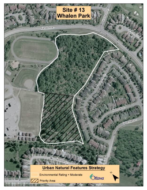
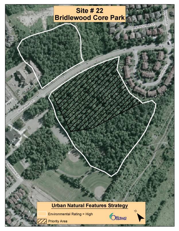
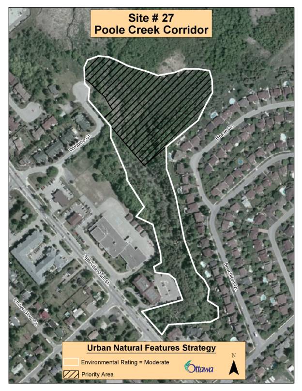
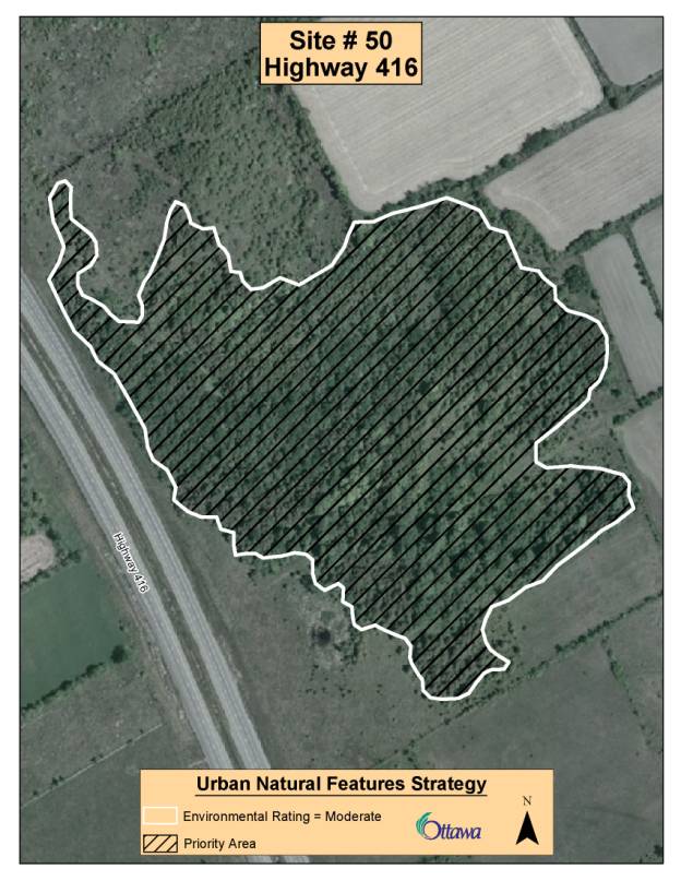
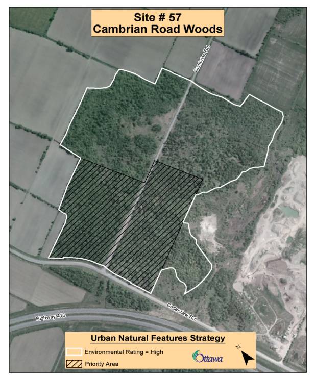
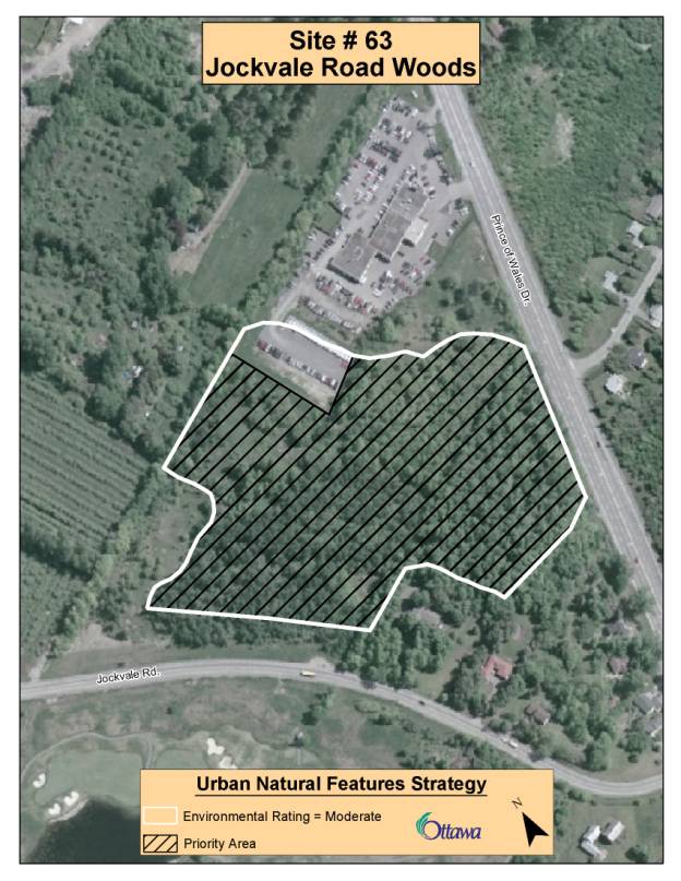
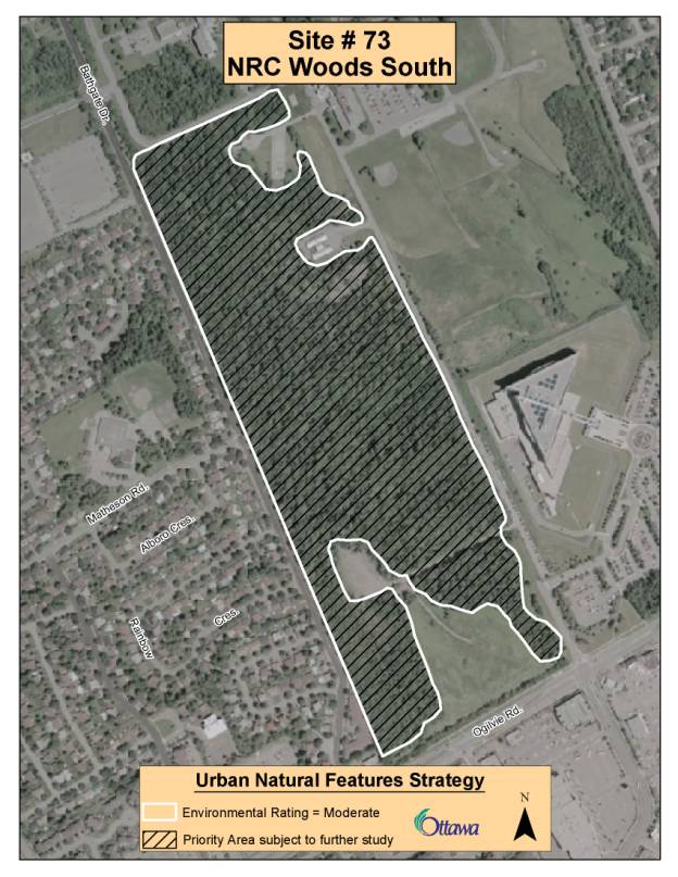
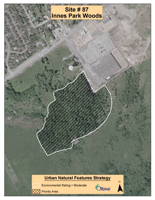
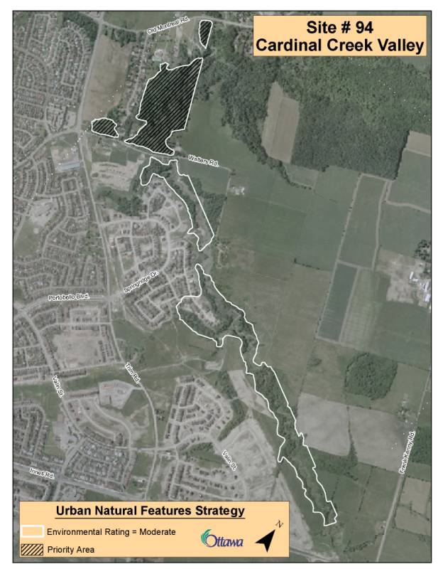
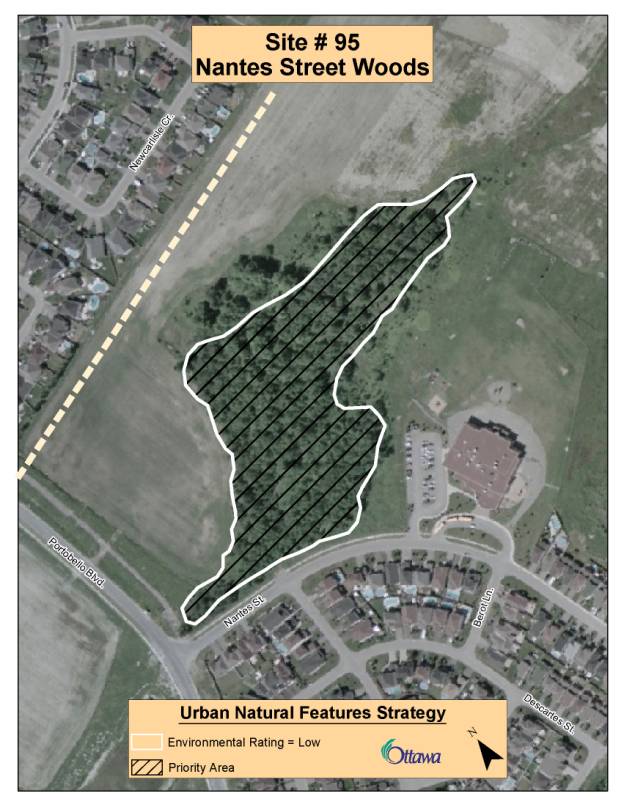
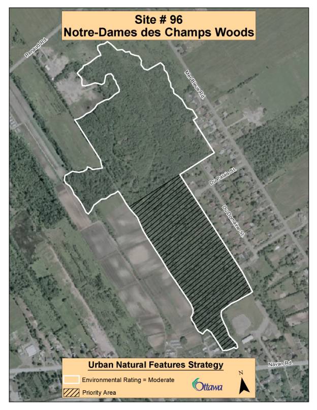
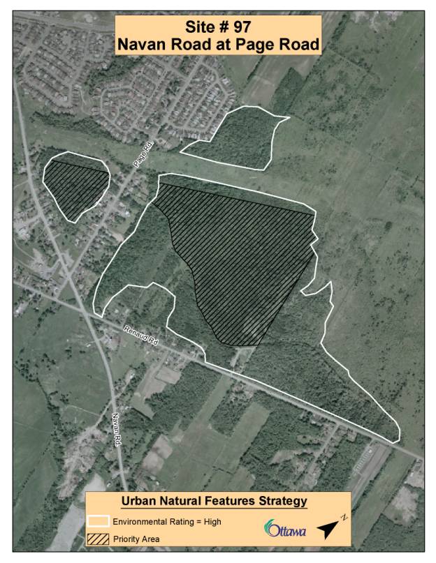
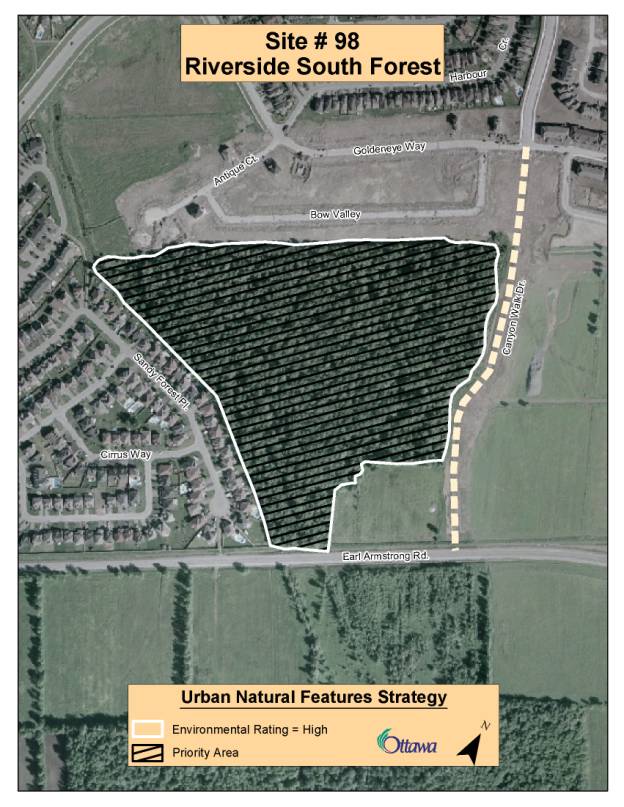
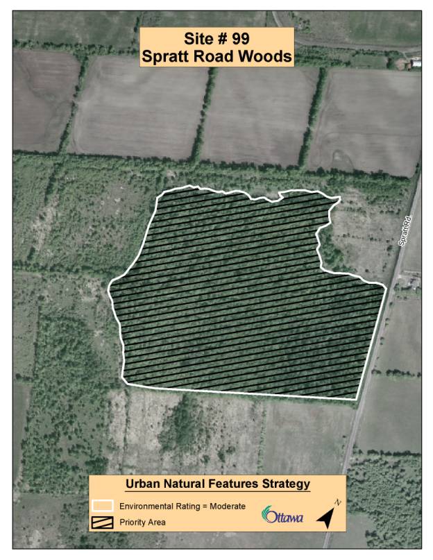
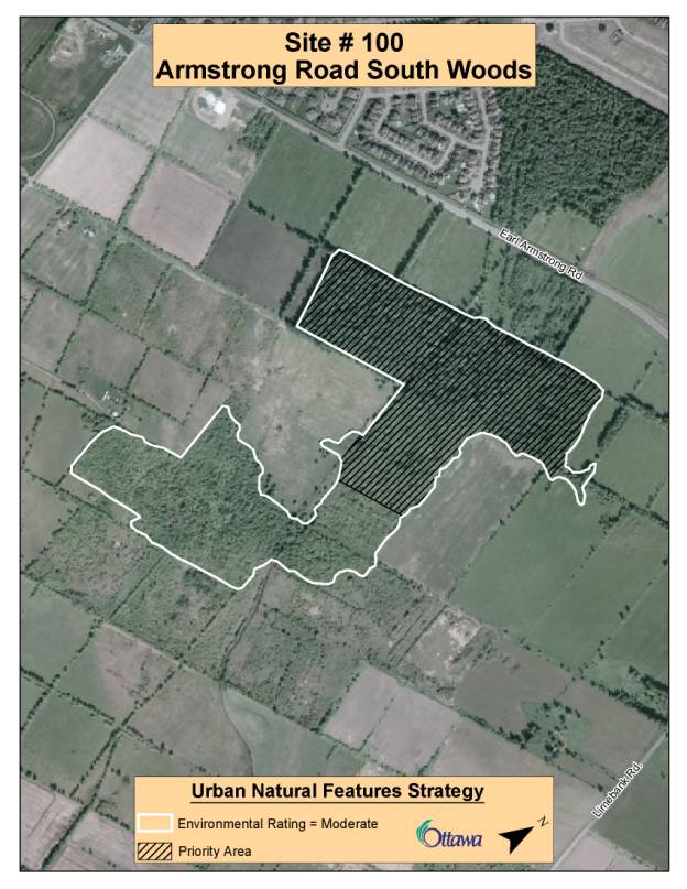
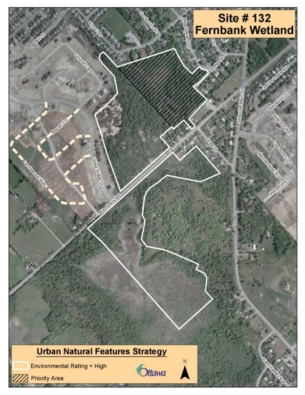
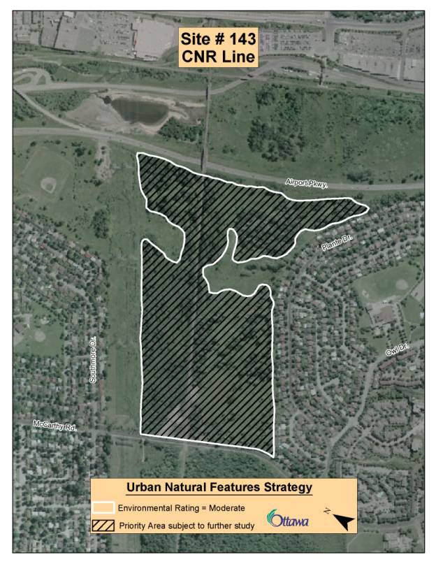
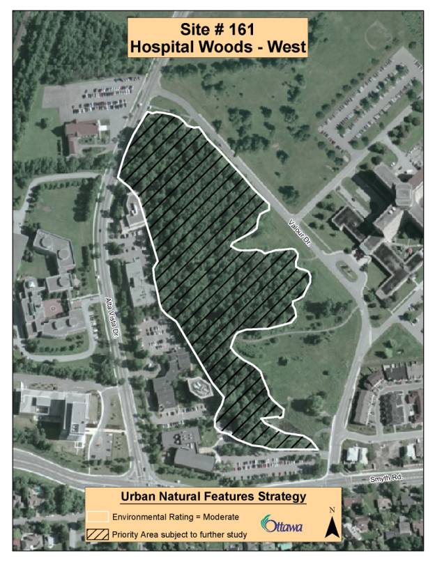
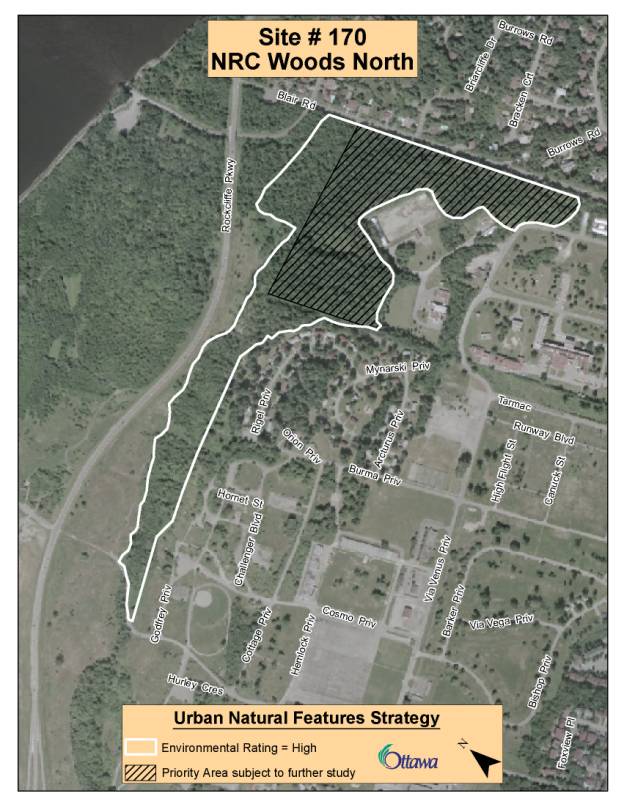
APPENDIX D LAND SECUREMENT TOOLS
|
Techniques
|
Description |
Advantages/ Disadvantages |
Legislative Basis |
Who/How Admini-stration |
Type of lands |
Examples |
|
|
|
|
|
|
|
|
|
Purchase
includes
“First Right of Refusal” Local
Area Levies and Local Improvement Charges |
Purchase
of land at fair market value. . |
City
or other group directly acquires land. Permanent protection and public
access. Options exist to recover costs through levies or charges on
benefiting owners. Acquisition
budget required to front end purchase. Cost recovery using taxes and levies
unpopular. |
Municipal
Act (right
of municipality to acquire and dispose of own land) and right of municipality
to levy local improvement charge on benefiting land |
City
of Ottawa, Other government Land Trusts, NonProfit
Groups (e.g., Nature Conservancy) Community
Cooperative Partnerships
|
Any
greenspace, particularly those requiring environmental protection. |
Marlborough
Forest (City) Burnt
Lands (Min. of Natural Resources & Nature Conservancy) Brampton,
Vaughn use Local improvement charges to acquire greenspace |
|
Land
Exchange (Equivalent
to Outright Purchase) |
Lands
or interest in land can be traded to achieve mutual interests, and net differences
in values can then be settled. |
Same
cost as purchase; permanent protection; public access possible Must
be equitable for both parties |
Municipal
Act (right
of municipality to acquire and dispose of own land) |
City/NCC
most common – public ownership |
Any
land or land use greenspace or other type of use including housing |
CityNCC
– Montfort Woods, Rockcliffe Park |
|
Donation/
Bequest, Including
a Life Estate |
Land
or interests in land donated during an individual’s lifetime or by private
corporation or as a bequest as part of an estate. The donor may opt to retain
use of land until death. |
Low
cost/ permanent protection and public access. Tax benefits for donor Lands
must meet Federal Tax rules for donation in order to qualify for tax
exemptions; |
Municipal
Act Income
Tax Act |
All
of the above Both
public and private ownership |
Any
greenspace or other type of lands including housing |
Rideau
Waterways Land Trust 24 ha near Kemptville Creek/Rideau River donation |
|
Parkland Dedication Under the Planning Act |
Lands
dedicated to municipality for parkland purposes as a result of subdivision
development. Usually
relates to recreation land but may be used to acquire natural areas |
Provides
parkland in growing communities: Can be converted to cash for more flexibility.
Planning
Act limits amount of land that can be required at no charge. |
Planning Act |
City ownership |
Any greenspace, but usually active parkland |
New
subdivisions in Orleans, Barrhaven, etc. |
|
Traditional
Land Use and Other Regulatory Controls |
Use
of land use planning (Official Plan/Zoning/ Subdivision Watershed and
Subwatershed Plans) and other regulatory controls. Land
Ownership does not change. |
Intent
for the land is provided in the Official Plan. Permanent protection can be
achieved. May
not be popular and does not provide for public access. May trigger requests
for financial compensation or purchase. |
Planning
Act Conservation
Authorities Act Fisheries
Act Trees
Act Aggregate
Resources Act |
City,
Province, Conservation Authorities Usually
private ownership or public ownership other than the City |
Any
greenspace if designation or zoning is not successfully challenged |
Significant
Wetlands designation in Official Plan Flood
plains ANSIs |
|
Sale
with Restrictions (Including acquisition and resale) |
Land
can be sold with restrictions in place to control future uses |
Generates
revenue while maintaining greenspace; permanent protection; public access can
be negotiated Restricted
land more difficult to sell, limited market and reduced value. |
Municipal
Act Conservation
land Act |
City/NCC/Prov.
Govt. |
Greenspaces
requiring environmental protection where public access may not be as critical |
Little
experience in Ontario. Variation used by Bruce Trail Association along
Niagara Escarpment |
|
Land
Trust |
Nonprofit
organizations dedicated to conserving open space, natural areas, etc. |
High
profile grassroots organization. Provides permanent protection and public
education. Limits
public access. Needs high profile and independence to get funds. |
|
Generally
nonprofit, incorporated community organization or a chapter within an
existing organization |
Usually
land needing environmental protection or recreational Trails |
Rideau
Waterway Land Trust Foundation |
|
Corporate
Landowner Agreement/ Condominium Agreement |
Similar
to Land Trust Conservation land can be owned by a shareholder’s corporation
or condominium devoted to the protection and management of the lands, |
An
alternative to government ownership and management; no cost; flexible;
management costs borne by those directly benefiting. Protection not
guaranteed Little
used; no guarantee of public access, needs a willing corporate entity |
Corporations
Act Condominium
Act |
Private
landowners, would not involve public ownership |
Any
greenspaces |
Grand
Hill Village Association, Kitchener |
|
Conservation
Easement |
An
agreement that restrict uses for conservation purposes, and when registered
on title they bind both current and future landowners |
Low
cost; may be more acceptable to landowner; can provide permanent protection/ Cost
of easements may be as great as purchase; public access may be limited;
requires ongoing monitoring; not extensively used in Ontario. |
Ontario
Heritage Act; Ministry of Government Services Act Ontario
Conservation Land Act |
Only
government agencies and registered charities including land trusts Private
ownership |
Usually
land needing environmental protection as well as heritage buildings |
Niagara
Escarpment – Ontario Heritage Foundation Carlington
Woods |
|
Restrictive
Covenant |
A
condition on title that restricts the landowner’s use of land or assigns
certain rights or access to an adjacent landowner. Applicable where a
government wishes to control land use but not own the land |
Low
cost; can provide permanent protection/ Can
only be used under certain conditions; unlikely to be able to specify
long-term management obligation. Public access not likely. |
Common
Law |
Any
government or conservation authority Private
ownership |
Usually
land needing environmental protection |
Township
of Chandos, Peterborough County |
|
Lease
/License |
A
lease gives exclusive rights to use land for a specified term and cost. Licenses
give permission to use a property for a purpose but not exclusive
rights and does not bind future owner |
Public
access can be negotiated/ Agreement
must be renewed periodically; may not protect land in perpetuity. |
|
Legal
lease or license agreement between parties Private
or public ownership |
Any
land |
City
leases Ledbury Park site from the NCC |
|
Incentives/
Assistance i.e. Tax Rebates/ Credits/ Management Agreements/
Funding Assistance |
Tax
or management incentives to encourage retention/ restoration of natural
areas. Usually linked to land use restrictions such as Provincial policy and
zoning. |
Lower
cost and non confrontational; willing landowner agreement/ Difficult
to monitor compliance; does not provide public access or permanent
protection. Lost tax revenue. |
Woodlands
Improvement Act; Games
and Fish Act; Conservation
Authorities Act; Conservation
Land Act |
Ministry
of Natural Resources; Conservation
Authorities Private
ownership |
Usually
land needing environmental protection |
Community
Wildlife Program and the Community Fisheries Program, Conservation Lands Tax
Reduction Program |
|
Stewardship
Support/
Education |
Private
land owner care and protection of land. Can be linked to incentives. |
Voluntary.
Least costly; nonthreatening;
builds rapport Not
permanent. No public access or protection. |
N/A |
Private
although all levels of government publicize and provide support |
Usually
land needing environmental protection |
Wetland
Habitat Fund, City of Ottawa’s “Green Acres Program” |
MCCARTHY WOODS MAP (UNA #144) DOCUMENT 2