|
2. ZONING – 1845 SECOND LINE ROAD ZONAGE
– 1845, CHEMIN SECOND LINE
|
Committee recommendation
(This application
is not subject to Bill 51)
Council
approve an amendment to the former City of Kanata March Rural Zoning By-law to
change the zoning of 1845 Second Line Road from Agricultural Zone, (AGR) to
Rural Residential Zone, (RR) as shown in Document 1 and as detailed in Document
2.
Recommandation du Comité
(Cette demande n’est pas assujettie
au projet de loi 51)
Que le Conseil approuve une modification
au Règlement de zonage rural de March de l’ancienne Ville de Kanata afin de
changer la désignation de zonage du 1845, chemin Second Line de zone agricole
(AGR) à zone résidentielle rurale (RR), tel qu’il est indiqué dans le document
1 et expliqué en détail dans le document 2.
Documentation
1.
Deputy
City Manager's report Planning,
Transit and the Environment dated
12 April 2007 (ACS2007-PTE-APR-0095).
2. Extract
of Draft Minutes 7, Agriculture and Rural Affairs Committee meeting of 26 April
2007
Report
to/Rapport au :
Agriculture and Rural Affairs Committee
Comité de l'urbanisme et de l'environnement
and Council / et au Conseil
12 April 2007 / le 12
avril 2007
Submitted
by/Soumis par : Nancy Schepers, Deputy City Manager/Directrice
municipal adjointe
Planning, Transit and the Environment / Urbanisme, Transport en commun
et Environnement
Contact
Person/Personne Ressource : Grant Lindsay, Manager / Gestionnaire,
Development Approvals / Approbation des demandes d'aménagement
(613)
580-2424, 13242 Grant.Lindsay@ottawa.ca
|
SUBJECT: |
|
|
|
|
|
OBJET : |
REPORT RECOMMENDATION
That the Agriculture and Rural Affairs Committee recommend Council approve an amendment to the former City of Kanata March Rural Zoning By-law to change the zoning of 1845 Second Line Road from Agricultural Zone, (AGR) to Rural Residential Zone, (RR) as shown in Document 1 and as detailed in Document 2.
RECOMMANDATION DU
RAPPORT
Que le Comité de l’agriculture et des affaires
rurales recommande au Conseil d’approuver une modification au Règlement de
zonage rural de March de l’ancienne Ville de Kanata afin de changer la
désignation de zonage du 1845, chemin Second Line de zone agricole (AGR) à zone
résidentielle rurale (RR), tel qu’il est indiqué dans le document 1 et expliqué
en détail dans le document 2.
BACKGROUND
The subject lands are located on the west side of Second Line Road, between March Road and Rocklane Drive. The subject parcel has a frontage of 135.5 metres along Second Line Road and is aproximately 18.9 hectares in area. The site is currently occupied by a detached dwelling and two barns being used as garages, which are located in the northeast corner of the site, adjacent to Second Line Road. The remainder of the property is open fields with some wooded areas. Lands to the north are developed as an estate lot residential subdivision (Rocklane and Vance Farm subdivisions), while lands to the south and west are a mix of agricultural and rural uses. Five small rural residential lots fronting onto Second Line Road back onto the subject site, while nearby lands on the east side of Second Line Road are largely occupied by estate lot subdivisions.
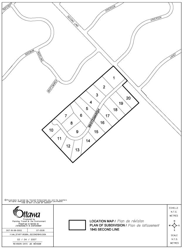
The concurrent application for a plan of subdivision proposes 20 residential lots with a minimum lot size of 0.8 hectares and a minimum frontage of 60 metres. The lots would front onto a new public street connecting to Second Line Road. Each lot would be serviced by way of an individual well and private sewage system. The existing dwelling and barns would remain on one oversized lot.
Details of Current and Proposed Zoning
The current zoning of the property is Agricultural Zone (AGR), under the March Rural By-law of the former City of Kanata. The current zoning permits a single detached dwelling, agricultural uses, animal hospital and commercial kennel.
The applicant proposes to rezone the property to Rural Residential Zone
(RR), to permit an estate lot subdivision. The standard provisions of the Rural
Residential Zone permit lots created by a plan of subdivision to have a minimum
lot area of 0.81 hectares and a minimum frontage of 60 metres. All
standard provisions of the RR Zone with respect to yard setbacks, lot coverage
and building height would be in effect for the lots within the proposed
subdivision.
DISCUSSION
Official Plan:
The subject site is designated as "General Rural Area" in the Official Plan. This designation permits a variety of land uses that are appropriate for the rural area, including rural housing, commercial development, small industries and farms. The intent of the designation is to accommodate land uses that are appropriate for a rural location, while allowing residential development where such use will not preclude agricultural and non-residential uses. Rural estate lot subdivisions are permitted within the “General Rural Area” designation, subject to a set of development criteria set out in Section 3.7.2.
Planning Rationale:
The subject application has been evaluated with regard to the provisions of the Official Plan, and all applicable policies have been satisfied. The subject property is designated General Rural Area on Schedule ‘A’ of the Official Plan. In accordance with Section 3.7.2(6) of the approved Plan, country lot subdivisions will be considered within the General Rural Area designation, subject to a set of criteria. Each requirement is identified below, along with a description of how the criteria have been satisfied:
a) All development will conform with the requirements from Section 4 of the Official Plan, including, but not limited to, protection of vegetative cover, water and wastewater services and erosion prevention.
· A Hydrogeological and Terrain Analysis was provided and reviewed by the Mississippi Valley Conservation Authority (MVCA). The analysis demonstrated there is a reliable supply of good quality water and the ability for safe disposal of wastewater.
·
The
required Preliminary Tree Preservation Plan has identified certain wooded areas
to be retained.
·
A
Conceptual Stormwater Management Plan has established that grading of the site
can be accomplished to prevent erosion or run-off issues.
b) All development will be evaluated within the context of any existing subwatershed studies or groundwater studies approved by the City.
·
The
groundwater study (Hydrogeology and Terrain Analysis) submitted was reviewed in
the context of all applicable policies and has been deemed acceptable by the
Mississippi Valley Conservation Authority.
c) The minimum lot size shall be 0.8 hectares, but studies may indicate the requirement for larger lots.
·
Each
lot meets the minimum 0.8 hectare requirement of the Official Plan. The
approved Hydrogeology and Terrain Analysis did not identify a need for larger
lots.
d) The maximum size of a country lot
subdivision shall be 40 lots.
· The proposed 20-lot subdivision is one-half of the maximum number of lots permitted.
e) Subdivisions may not impede the ability of villages and urban areas to expand over the planning period, and may not be located within one kilometre of an approved urban and village boundary
·
The
subject site is not located within one kilometre of an approved urban or
village boundary.
f) Subdivisions will
not create conflicts with non-residential uses that need to locate in the rural
area.
· There is no conflict with adjacent land uses, which are residential or agricultural in nature. There are no Minimum Distance Separation issues with respect to the existing barns on the property. These barns, which are to remain on one of the lots abutting Second Line Road, are currently used as garages. There would be no potential for agricultural use of the barns once the rezoning is in effect.
g) Subdivisions will develop where there is the
least impact on municipal operations.
·
There
are no issues related to this matter, as the lots will be privately serviced.
Access to the property will be from a paved public road.
h) Subdivisions will be planned on the basis of assessments of sufficient detail to ensure the long-term quality and quantity of the groundwater.
· The MVCA has accepted the technical studies undertaken by the consultants with respect to the Hydrogeological Report and Terrain Analysis. They are satisfied that the hydrogeological analysis adequately demonstrates there is a sufficient quantity of water as well as an acceptable water quality available on site. There is no projected impact on existing wells in the surrounding area. Site conditions have also been shown to be suitable for dilution of the septic effluent to satisfy Ministry of Environment requirements and avoid any impacts on the adjacent development.
The proposed subdivision complies with all Official Plan policies. The applicable setbacks would be those set out by the standard Rural Residential Zone, which are in effect for the numerous surrounding country lot subdivisions in the immediate vicinity of the subject property. The proposed rezoning is therefore in keeping with the general character of the surrounding rural area.
Through the associated subdivision application, all issues associated with the proposed development have been addressed. Following review and acceptance of the required technical studies, City staff and the Conservation Authority have no objections to the proposed rezoning and subdivision applications. Staff support this Zoning By-law amendment because the proposed use is compatible with the surrounding area and conforms to the applicable policies outlined within the Official Plan.
RURAL IMPLICATIONS
The proposed Zoning
By-law is not expected to have any adverse impact on the existing uses within
the rural area, and is considered appropriate given the surrounding context. Although the land is within an Agricultural Zone, the lands are not
designated for agricultural use in the Official Plan, and the proposed
development is compatible with the adjacent country lot developments. To minimize any impact the proposed Zoning
By-law amendment and proposed plan of subdivision may have on the adjacent
rural use to the south, appropriate fencing and tree retention will be
implemented through the Draft Plan Conditions of the subdivision.
CONSULTATION
Notice of this application was carried out in accordance with the City's Public Notification and Consultation Policy (see Document 4). The Ward Councillor is aware of this application and the staff recommendation.
FINANCIAL IMPLICATIONS
APPLICATION PROCESS TIMELINE STATUS
The application was processed by the "On Time Decision Date" established for the processing of Zoning By-law amendments. The application was On Hold for several months while the associated subdivision application was processed.
SUPPORTING DOCUMENTATION
Document 1 Location Map
Document 2 Details of Recommended zoning
Document 3 Consultation Details
Document 4 Draft Subdivision Plan
DISPOSITION
Corporate Services Department, City Clerk’s Branch, Secretariat Services to notify the owner, (1649074 Ontario Inc., 2117 Lambeth Walk, Ottawa, Ontario K2C 1E8, Attention: Ms Catharina Yendall), applicant, (Novatech Engineering Consultants Ltd., 240 Michael Cowpland Drive, Suite 200, Ottawa, Ontario K2M 1P6, Attention: Mr. Mike Michaud), Signs.ca, 866 Campbell Avenue, Ottawa, ON, K2A 2C5, Ghislain Lamarche, Program Manager, Assessment, Financial Services Branch (Mail Code: 26-76) of City Council’s decision.
Planning, Transit and the Environment Department to prepare the implementing by-law, forward to Legal Services Branch and undertake the statutory notification.
Corporate Services Department, Legal Services Branch to forward the implementing by-law to City Council
LOCATION MAP DOCUMENT
1
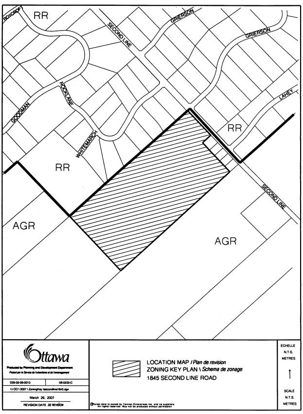
DETAILS OF RECOMMENDED ZONING DOCUMENT 2
The lands known municipally as 1845 Second Line Road will be rezoned from Agricultural Zone (AGR) to Rural Residential Zone (RR).
CONSULTATION DETAILS DOCUMENT
3
NOTIFICATION AND CONSULTATION PROCESS
Notification and public consultation was undertaken in accordance with the Public Notification and Public Consultation Policy approved by City Council for Zoning By-law Amendments.
A public meeting was held in the community on July 12, 2006, in fulfillment of the requirements for the associated subdivision application. The following issues were identified:
Lot size and technical studies
Comments: The March Rural Community Association raised concerns with respect to the hydrogeological issues related to the proposed subdivision: They expressed a desire for a cumulative impact study on water resources of rural Kanata, and opposed the practice of allowing the minimum lot size of 0.8 hectares, as allowed by the Official Plan, to become the standard size for rural residential lots. They also expressed concern with regard to the standards of septic system construction, and the elevated sodium levels in the water. The comments made reference to technical studies conducted many years ago for the former Region of Ottawa-Carleton and the former City of Kanata.
Response: Mississippi Valley Conservation Authority, after reviewing the Hydrogeological and Terrain Analysis, confirmed the proposed rezoning and subdivision applications meet Ministry of Environment Procedures D-5-4 and D-5-5. Ministry of Environment Procedures D-5-4 and D-5-5 were created for the purpose of protecting existing residents and prospective purchasers from issues relating to water and sewage impacts. The (Provincial) policies were approved in 1996, after the studies reference by the March Rural Association. All standards, criteria and guidelines established by the Province are to be satisfied for the proposed subdivision.
Fencing
Comments: The owner of the abutting agricultural lands to the south requested that a 1.5‑metre pagewire fence be installed along the southerly property line of the lots to be created.
Response: The Conditions of Draft Plan Approval for the subdivision incorporate the requirement for a 1.5‑metre pagewire fence along the southerly and westerly property lines, to the City's satisfaction.
Ground Water Issues
Comments: Nearby residents expressed concern about their quality and quantity of groundwater once the proposed subdivision is fully built out. There was also concern expressed that new residents would be unaware of the maintenance requirements for the septic systems.
Response: As noted in the response above, the Conservation Authority has confirmed that the proposed subdivision has satisfied all policies and technical requirements with respect to hydrogeological issues. As with all rural subdivisions, the Draft Plan Conditions include a condition that the subdivision agreement and all agreements of purchase and sale must contain a warning clause that the City of Ottawa does not guarantee the quality or quantity of the groundwater. The subdivision agreement and all agreements of purchase and sale all offers of shall include warning clause that the private services (well and septic system) require annual maintenance, and specify the availability of information guides for homeowners through various agencies.
Tree Preservation:
Comments: nearby residents expressed a desire to retain existing wooded area where possible.
Response: The Preliminary Tree Planting and Preservation Plan identified areas of trees to be retained to provide wooded area on the lots. The Draft Plan Conditions, to be incorporated into the subdivision agreement, specify that existing wooded areas are to be retained as much as possible. In addition, the building envelope for certain wooded lots will be defined to preserve trees. Other specific trees of significance have been selected for retention throughout the site. Staff will implement protection measures during construction to ensure the above-noted trees are retained where possible. A detailed landscape plan will be submitted at a late date to the implement the preliminary tree preservation plan and indicate location of proposed new planting.
DRAFT PLAN OF SUBDIVISION DOCUMENT 4