|
1. ZONING - 1905 MARCHURST ROAD
(1913 MARCHURST ROAD) ZONAGE – 1905, CHEMIN MARCHURST (1913, CHEMIN MARCHURST) |
Committee recommendation
(This application
is not subject to Bill 51)
That Council
approve an amendment to the former Kanata Residential Zoning By-law (74-79) to
change the zoning of 1905 Marchurst Road (1913 Marchurst Road) from Estate
Residential (ER) and Agriculture (AGR) to Rural Residential (RR), Rural
Residential Exception (RR-x), Rural Residential Exception (RR-xy), Rural Residential
Exception (RR-xy-H), Rural Residential Holding Provision (RR-xz-H), Open Space
Exception (OS-x), and Conservation Exception (CON-x) as shown in Document 1 and
detailed in Document 2.
Recommandation du Comité
(Cette demande n’est pas assujettie
au projet de loi 51)
Que le Conseil approuve une
modification au Règlement de zonage résidentiel (74-79) de l’ancienne Ville de
Kanata afin de changer la désignation de zonage du 1905, chemin Marchurst
(1913, chemin Marchurst) de zone résidentielle de grand ensemble (ER) et zone
agricole (AGR) à zone résidentielle rurale (RR), zone résidentielle rurale
assortie d’une exception (RR-x), zone résidentielle rurale assortie d’une
exception (RR-xy), zone résidentielle rurale assortie d’une exception
(RR-xy-H), zone résidentielle rurale assortie d’une exception avec utilisation
différée (RR-xz-H), zone d’espaces libres assortie d’une exception (OS-x) et à
zone de conservation assortie d’une exception (CON-x) comme ils est indiqué
dans le document 1 et expliqué en détail dans le document 2.
Documentation
1.
Deputy
City Manager's report Planning,
Transit and the Environment dated
2 April 2007 (ACS2007-PTE-APR-0089).
2. Extract of Minutes 6, Agriculture
and Rural Affairs Committee meeting of 12 April 2007.
3. Extract of Draft Minutes 7,
Agriculture and Rural Affairs Committee meeting of 26 April 2007.
Report
to/Rapport au :
Agriculture and Rural Affairs Committee
Comité d'agriculture et des questions
rurales
and Council / et au Conseil
2 April 2007 / le 2 avril 2007
Submitted by/Soumis par : Nancy Schepers, Deputy City Manager/Directrice municipale
adjointe
Planning, Transit and the Environment/
Urbanisme, Transport en commun et Environnement
Contact Person/Personne ressource : Grant Lindsay,
Manager / Gestionnaire
Development Approvals / Approbation des
demandes d'aménagement
(613) 580-2424 x13242,
Grant.Lindsay@ottawa.ca
|
SUBJECT: |
ZONING - 1905 Marchurst Road (1913
marchurst road) (FILE NO. d02-02-05-0088) |
|
|
|
|
OBJET : |
REPORT RECOMMENDATION
That Agriculture and Rural
Affairs Committee recommend Council approve an amendment to the former Kanata
Residential Zoning By-law (74-79) to change the zoning of 1905 Marchurst Road
(1913 Marchurst Road) from Estate Residential (ER) and Agriculture (AGR) to
Rural Residential (RR), Rural Residential Exception (RR-x), Rural Residential
Exception (RR-xy), Rural Residential Exception (RR-xy-H), Rural Residential
Holding Provision (RR-xz-H), Open Space Exception (OS-x), and Conservation
Exception (CON-x) as shown in Document 1 and detailed in Document 2.
RECOMMANDATION DU
RAPPORT
Que le Comité de
l’agriculture et des affaires rurales recommande au Conseil d’approuver une
modification au Règlement de zonage résidentiel (74-79) de l’ancienne Ville de
Kanata afin de changer la désignation de zonage du 1905, chemin Marchurst
(1913, chemin Marchurst) de zone résidentielle de grand ensemble (ER) et zone
agricole (AGR) à zone résidentielle rurale (RR), zone résidentielle rurale
assortie d’une exception (RR-x), zone résidentielle rurale assortie d’une
exception (RR-xy), zone résidentielle rurale assortie d’une exception
(RR-xy-H), zone résidentielle rurale assortie d’une exception avec utilisation
différée (RR-xz-H), zone d’espaces libres assortie d’une exception (OS-x) et à
zone de conservation assortie d’une exception (CON-x) comme ils est indiqué
dans le document 1 et expliqué en détail dans le document 2.
BACKGROUND
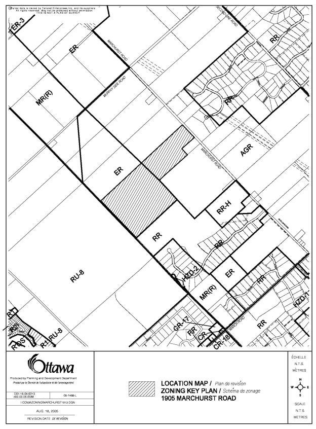
The subject property is located north of March Road and south of Murphy's Side Road, at 1905 Marchurst Road, in the West Carleton-March Ward.
The westerly boundary of the site abuts the unopened road allowance of Huntmar Road. Further to the west of this unopened road allowance is the Carp Hills Natural Area. The southern boundary abuts a 0.8-hectare farm retirement lot, a working farm, and an Estate Residential development. The northern boundary of the site abuts an active farm, while the easterly boundary abuts Marchurst Road. The site is 58 hectares in size and is currently vacant. The easterly portion of the site is relatively flat, with only a few trees along the boundary of the property. The westerly half of the property is flat with rolling hills, treeless areas and several outcroppings of rocks. Two woodlots are also located on the western portion of the site.
The proposed plan of subdivision is for a Rural Residential development, consisting of 48 lots and two residential blocks. The lots will have a minimum size of 0.8 hectares and a minimum frontage of 60 metres. A private open space block has been proposed for the development, to be utilized by the residents of the development. All water and sanitary services will be private.
The original proposal submitted to the City was for a 54 residential lot development with a private open space trail network connecting around the perimeter of the site with a 1.3-hectare pond as an entrance feature. The concepts of the trail network and pond were abandoned and there was a request to allow one lot within the Plan of Subdivision to accommodate for uses that could be accessed and utilized by the residents of the subdivision, such as an assembly hall, common guest house or bed and breakfast establishment and a personal service shop use. These were minor in nature and evolved out of the subdivision circulation and review process. The additional or communal uses to the residential subdivision are subordinate or accessory to the function of the subdivision.
DISCUSSION
Official Plan
The subject property is designated
"General Rural Area" within the Official Plan. This designation permits a variety of land
uses, such as farms, rural housing, wood lots, small industries, golf courses
and small clusters of residential and commercial uses. Country lot subdivisions are considered
within the General Rural Area designation subject to a set of development criteria.
Details of Current and Proposed Zoning
The Zoning By-Law of the former City of Kanata
(March Rural 74-79) zones this property "Estate Residential" (ER) and
"Agricultural" (AGR). Both
the Estate Residential zone and Agricultural zone permit single detached
dwellings, agricultural uses and forestry management uses. The major difference between these two zones
is the land area requirements are much larger for the Agricultural zone (20
hectares) compared to the Estate Residential zone (four hectares). The applicant wishes to rezone the property
to change the zoning of 1905 Marchurst Road from Estate Residential (ER) and
Agriculture (AGR) to Rural Residential (RR), Rural Residential Exception
(RR-x), Rural Residential Exception (RR-xy), Rural Residential Exception
(RR-xy-H), Rural Residential Holding Provision (RR-xz-H), Open Space Exception
(OS-x), and Conservation Exception (CON-x) to permit a Rural Residential
development on 0.8‑hectare lots.
Planning Rationale
The subject application has been
examined pursuant to the provisions of the Official Plan and all applicable
policies have been satisfied. In
accordance with Section 3.7.2 (6) of the Plan, country lot subdivisions will be
considered within the General Rural Area designation subject to criteria
including, but not limited to, protection of vegetative cover, water and
wastewater services, and erosion prevention.
Through required plans and studies the subject application has
demonstrated it meets this relevant criteria.
In addition to permitting country lot
subdivisions, there are four other issues that will ultimately affect the
zoning on the subject property. These
four issues are; Residential exceptions, Private Open Space, Buffer
Requirements and Minimum Distance Separation Requirements.
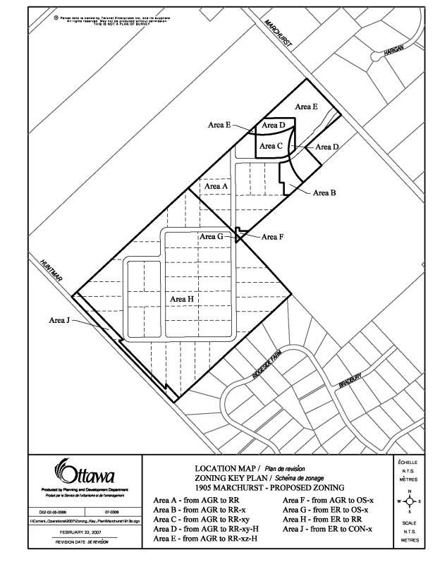
Rural Residential Exceptions:
The majority of the property will be rezoned
from Estate Residential and Agricultural zones to Rural Residential zones. However, there are four areas that are
identified to include Rural Residential Exception zones to permit exceptions to
the requested Rural Residential zone.
The exceptions to the Rural Residential zone
are located in Areas B, C, D and E within Document 3:
- Area
B will permit Rural Residential with a special Lot Frontage of 35 metres
(RR-x)
- Area
C will permit Rural Residential, Personal Service Shop, Bed and Breakfast
Establishment, and Assembly Hall uses (RR-xy)
- Area
D will permit Rural Residential, Personal Service Shop, Bed and Breakfast
Establishment, and Assembly Hall uses (RR-xy-H) under a holding provision,
with the base zone being Agriculture (AGR)
- Area
E will permit Rural Residential uses under a holding provision (RR-xz-H),
with the base zone being Agriculture (AGR)
Open Space Exception:
The proposed Open Space Exception designation
will apply to Area F and Area G in Document 3. Staff recommend that the proposed private park block be zoned
Open Space (OS) – exception zone. The
exception zone will ensure the park is held in private ownership.
Minimum Buffer from Carp Ridge:
The recommendations to create a
"no-touch" setback for the purpose of retaining a natural condition
along the west edge of the site (Area J in Document 3), identified in the
"Environmental Impact Statement and Preliminary Tree Study", will be
implemented through zoning. A 30-metre
buffer within the northwest forest and a portion of the southwest forest, and a
15-metre buffer along the agricultural fields and the existing cleared access
road in the central and north portions of the southwest forest will be rezoned
from Estate Residential to Conservation Exception zone (CON-x). The Conservation Exception zone will aid in
conserving the natural attributes of the forest and protect the Carp
Ridge. This exception zone shall
prohibit any structure and the alteration of the natural environment.
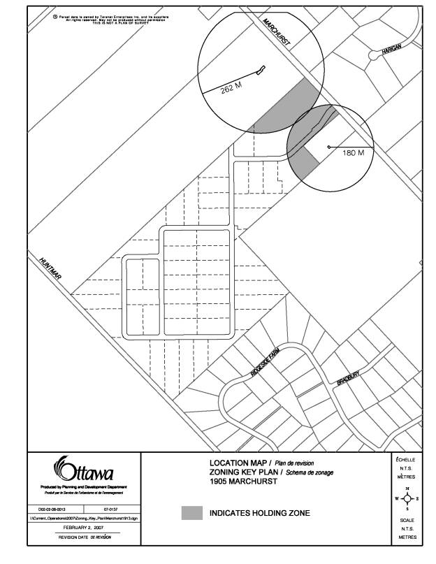
Minimum Distance Separation (MDS I):
The MDS I report identified barns associated to
farm operations on adjacent properties to the north and south that have an
impact on the capabilities to develop the subject site. Minimum Distance Separation calculations
exposed a radius of 262 metres from the barns to the north and 180 metres from
the barns to the south. These two
calculations are illustrated in Document 4, showing the impact of the MDS
policies on adjacent lots.
The MDS I setbacks impact several lots on the
proposed Draft Plan of Subdivision.
These lots shall have special designations to identify the restrictive
nature of the MDS policies. Where the
MDS arc touches each lot, a holding symbol (H) shall be implemented to prohibit
the proposed use. The areas impacted by
the separation requirements are shown in Document 4 and the individual holding
designation for each area affected are illustrated in Document 3.
- Area
B will reflect a special Lot Frontage of 35 metres to compensate for the
fact that the base zone of Agriculture will dissect the lot frontage,
leaving Block 50 on the Draft Plan of Subdivision deficient from the
Zoning By-law provisions for Lot Frontage.
- Area
D will restrict Rural Residential, Personal Service Shop, Bed and
Breakfast Establishment, and Assembly Hall uses until such time the H has
been lifted
- Area
E will restrict Rural Residential uses until such time the H has been
lifted
ENVIRONMENTAL IMPLICATIONS
The Carp Hills Natural Area is located west of
the subject site, with a portion of the forest in the northwest corner of the
site to be included in this natural area.
These lands are designated “Natural Environment Area” (NEA) within the
Official Plan. The NEA applies to areas
having high environmental value and identifies sensitive areas where
development could unduly stress ecological functions and where careful
management is required.
The Carp Hills Natural Area was considered to
have a high overall significance in the evaluation summary performed as part of
the Natural Environment System Strategy by the former Region of Ottawa-Carleton
(Brunton, 1997).
An Environmental Impact Statement prepared by
Muncaster Environmental Planning Inc., has stated that “indirect impacts could
occur on the Carp Hills Natural Area to the west of the site as a result of the
construction and operation of the residential development.” These indirect impacts could include:
- greater
human, pet and other urban wildlife intrusions into the adjacent natural
areas. Indirect impacts may also
occur due to increases in noise and light pollution;
- increased
sediment loadings and other contamination of surface water runoff during
construction from machinery maintenance and operations, leading to erosion
and other impacts on the natural area; and,
- a
degradation in water quality through increased levels of fertilizers and
pesticides in surface water runoff.
The potential impacts will be mitigated and
greatly reduced by the implementation of a 30-metre ‘no-touch’ zone and
15-metre ‘no-touch’ zone located along the western boundary of the subject site
and the Carp Hills Natural Area. This
buffer area will prohibit grading and other site alterations.
RURAL IMPLICATIONS
The subject Zoning By-law
amendment is not anticipated to adversely impact existing uses within the rural
area and is appropriate given the surrounding context. Abutting the southwest property line of 1905
Marchurst Road is an approved Draft Plan of Subdivision (Land Ark Homes) for 88
lots. Located north and east of the
rezoning are both existing and currently operating farm lots. To minimize impacts the proposed zoning may
have on these lots, Minimum Distance Separation studies were undertaken. As a result, buffers have been factored into
the Zoning By-law amendment to ensure the viability of existing farms is not
compromised.
CONSULTATION
Notice of this application was
carried out in accordance with the City’s Public Notification and Consultation
Policy. The Ward Councillor is aware of
this application and the staff recommendation.
Detailed responses to the notification/circulation are provided in Document 5.
FINANCIAL IMPLICATIONS
APPLICATION PROCESS
TIMELINE STATUS
The application was not processed by the
"On-Time Decision Date" established for the processing of Zoning
By-Law amendments due to significant time allocated to the review and revision
of the Hydrogeological Report as well as the resolution in of Minimum Distance
Separation issues.
SUPPORTING DOCUMENTATION
Document 1 Location Map
Document 2 Details
of Recommended Zoning (text)
Document 3 Details
of Recommended Zoning (map)
Document 4 Details
of Recommended Zoning - Holding Symbol
Document 5 Consultation Details
DISPOSITION
Corporate Services Department, City
Clerk's Branch to notify the owner (Golden Apple Developments Inc., 50 Mark
Ave., Apt 6, Ottawa, ON, K1L 6A7), applicant (Ray Essiambre, Ainley Group, 2724
Fenton Road, Gloucester, ON, K1T 3T7), Signs.ca, 866 Campbell Avenue, Ottawa,
ON K2A 2C5, and Ghislain Lamarche,
Program Manager, Assessment, Financial Services Branch
(Mail Code: 26-76) of City Council's decision.
Planning, Transit and the Environment
Department to prepare the implementing by-law, forward to Legal Services Branch
and undertake the statutory notification.
Corporate Services Department, Legal Services
Branch to forward the implementing by-law to City Council.
LOCATION MAP DOCUMENT
1
DETAILS OF RECOMMENDED ZONING DOCUMENT 2
i) Schedule A of By-law 74-79 to be
amended to show that the subject lands shown on Document 3 will be rezoned as
follows:
Area A - from AGR to RR –
Residential Rural Zone
Area B – from AGR to RR-x –
Residential Rural Exception Zone
Area C – from AGR to RR-xy –
Residential Rural Exception Zone
Area D – from AGR to RR-xy-H –
Residential Rural Exception Zone
Area E – from AGR to RR-xz-H –
Residential Rural Holding Provision
Area F – from AGR to OS-x – Open
Space Exception Zone
Area G – from ER to OS-x – Open
Space Exception Zone
Area H – from ER to RR – Residential
Rural Zone
Area J – from ER to CON-x –
Conservation Exception Zone
ii) Area A lands to be rezoned from AGR to RR
iii) Area
B lands to be rezoned from AGR to RR-x and will be subject to the following:
(a) Notwithstanding
any provision of Section 11 hereof to the contrary, the lands designated RR-x
on Schedule "A" hereto must be used in accordance with the following
requirements:
1.
Lot
Frontage New Lot – minimum 35 metres
iv) Area
C lands to be rezoned from AGR to RR-xy and subject to the following:
(a) Notwithstanding any provision of Section 11 hereof to the contrary, the lands designated RR-xy on Schedule "A" hereto must be used in accordance with the following requirements:
- Additional permitted uses
- Service Establishment, Personal
- Bed and Breakfast Establishment;
- Assembly Hall.
- Notwithstanding subsection 2.15, for the lands zoned RR-xy, the
term Bed and Breakfast Establishment means a fully-detached dwelling in
which rooms may be rented to accommodate the traveling public for gain or
profit, and may include the provision of meals to the guest room occupants
and which is the principal residence of the operator of the Bed and
Breakfast Establishment. Such
establishments may not contain more than five (5) rented rooms or a number
of rented rooms equivalent to one (1) less than the total number of
bedrooms in the dwelling, which ever is the lesser.
v) Area
D lands to be rezoned from AGR to RR-xy and will be subject to the following:
(a)
On any lands zoned RR-xy on Schedule A to By-law 74-79
where there is a holding symbol (H), the holding designation may be lifted when
it can be demonstrated that the required minimum distance separation is no
longer applicable. Once the H is
lifted, the lands will be governed by the provisions of the RR-xy zone.
vi) Area
E lands to be rezoned from AGR to RR-xz and will be subject to the following:
(a) On any lands zoned RR-xz on Schedule A to By-law 74-79 where there is a holding symbol (H), the holding designation may be lifted when it can be demonstrated that the required minimum distance separation is no longer applicable. Once the H is lifted, the lands will be governed by the provisions of the RR zone.
vii) Area
F lands to be rezoned from AGR to OS-x and will be subject to the following:
(a) Notwithstanding any provision of Section
16 hereof to the contrary, a Private Park, which means a park held in private
ownership dedicated to recreational, cultural, or conservation purposes, is a
permitted use on the lands designated OS-x.
viii) Area G lands to be rezoned from ER to OS-x and will be subject
to the following:
(a) Notwithstanding any provision of Section 16 hereof to the contrary, a Private Park, which means a park held in private ownership dedicated to recreational, cultural, or conservation purposes, is a permitted use on the lands designated OS-x.
ix) Area
J lands to be rezoned from ER to CON-x and will be subject to the following:
(a) Section 7 is amended by adding a new
subsection entitled Special Conditions.
(b) Notwithstanding
any provision of Section 7 hereof to the contrary, a Conservation Use, which
means the maintenance
of the natural environment for the purposes of preservation, is the only
permitted use on the lands designated CON-x.
DETAILS OF RECOMMENDED ZONING DOCUMENT 3
DETAILS OF RECOMMENDED ZONING (HOLDING SYMBOL) DOCUMENT 4
CONSULTATION DETAILS DOCUMENT
5
This application was subject to the Public
Notification and Consultation Policy. Enhanced notification was carried out and included a
public meeting held November 24th, 2005 at the Kanata Recreation Complex. The meeting was attended by 19 members of
the community and their comments are summarized below:
Summary and Response to Comments
Comment 1.
Density:
- How
can lots be reduced from 2-4 hectares to only 0.8 hectares without relying
on tertiary septic systems?
- We
recommend that development should be phased in several stages with follow
up water testing done at each stage, including on neighbouring wells with
consent of existing home owners
Answer 1:
The City’s Official Plan allows for 0.8-hectare
size lots subject to studies that indicate this particular lot size is adequate
for wells and sewage systems. The
Terrain Analysis supported the 0.8-hectare size lots and was deemed
satisfactory based on the determination that all lots within the subject
property can accommodate a Conventional Septic System. If, through the assessment of the Terrain
Analysis, it was determined a particular lot could not accommodate a Conventional
Septic System, the Report would not be approved.
Following approval of the Plan of Subdivision,
Tertiary Systems may be utilized despite the understanding that all lots can
accommodate a Conventional Septic System.
The Tertiary System may be implemented where several factors combine to
make placement of a Conventional Septic System difficult. These factors may include; irregular
topography, high ground water table, proximity of bedrock to the soil surface,
size of house, location of house.
A sewage system is submitted to the Ottawa
Septic System Office (OSSO) for review and approval. The sewage system will evaluated against the environmental
factors for the individual lot and a permit will be released provided the
design meets required standards and criteria.
The following condition
will be incorporated into the subdivision agreement, and will address the
requirement to phase the development and test the operational evaluation of the
wells and private sewage systems in the previous phase(s) of development. It is not common practice to complete an
evaluation of existing neighbouring wells and private sewage systems after the
development of each phase:
“The registration
of this subdivision shall be phased.
Each phase of registration is to contain not more than 40 lots. Prior to the registration of each phase
subsequent to the previous phase, the Owner shall submit a Performance Review
of the operation of wells and private sewage disposal systems in the previous
phase(s) of the development demonstrating that the previous phase(s) are
operating satisfactorily. A qualified
Professional Engineer, with experience in hydrogeology, or a professional
geoscientist shall prepare the Performance Review. The final number of lots
required for analysis must be supported in the Performance Review, but in any
case the Performance Review shall only be prepared and submitted for review
once not less than 50% of lots in the previous phase have built and occupied,
and, when requesting the registration of any phase beyond the second phase, a
representative number of lots in the oldest phases must also be analysed. Further, the Owner agrees that prior to the
registration of each phase, lots in that phase or any subsequent phase will not
be offered for sale, nor will the Owner apply for building permits.”
Comment 2.
Water Issues:
- 6 of
the 7 test wells exceed the MOE water quality objective for sodium and the
majority show sodium levels that are two to three times this
standard. Such concentrations
require the notification of the Medical Officer of Health.
- The
vast majority of wells exceed guidelines for iron, which will result in a
bitter taste, brownish colour and promote growth of iron bacteria
in the water piping.
- 6 of
12 tests resulted in magnesium that is three to six times the MOE
objective. These wells will prove
both expensive and problematic to homeowners and treatment will result in
undesirable chemicals entering the groundwater. This should clearly be made known to potential home-buyers.
Answer 2:
Notification will be given in all Purchase and Sale Agreements and Covenants on Title regarding the Medical Officer of Health’s warning for sodium levels.
All parameters related to water
quality conform to Ministry of Environment standards, and the local
Conservation Authority has approved the Hydrogeological report.
Well construction must
be carried out as per the recommendations of the Hydrogeological Report. The following condition has been added to
the subdivision agreement to address this issue:
“The Owner agrees that
all well construction, including test wells, shall be in accordance with the
recommendations of the approved Hydrogeological and Terrains Analysis Report,
and that certification by a Professional Engineer will be provided to the
Mississippi Valley Conservation in this regard. The Owner shall advise all prospective lot purchasers, in the
Agreements of Purchase and Sale and in the Deed(s), of these certification
requirements. The Owner also agrees
that the Subdivision Agreement with the City of Ottawa will require the
Mississippi Valley Conservation to indicate satisfaction with the well
certification, prior to final inspection by the City of Ottawa to permit
occupancy of any buildings.”
Comment 3. Parkland:
- It
is recommended that 5% allocation for public parkland be considered at
this location, as there is a shortage of playing fields and parkland in
the rural Kanata area.
- The
MRA wishes to confirm that the 20 parking spaces shown adjacent to the
pond on the drawing was an error.
This is wholly inconsistent with the ‘private’ trails. If the developer wants to have a
private park inside the property giving access to private trails, parking
for it should be on internal roads.
Answer 3:
Due to the location of adjacent working farms
and associated barns Minimum Distance Separation (MDS) guidelines, developed by
the Ministry of Agriculture, Food and Rural Affairs, must be enforced at this
location. The objective of the MDS
guidelines are to minimize nuisance complaints due to odour and thereby reduce
potential land use conflicts. An
environmental report two barns adjacent the subject property, and therefore
resulted in the requirement of the proposed parkland and residential uses
within the Plan of Subdivision to be set back a minimum distance from these
barns.
It was the position of the City that accepting a parkland dedication that cannot be developed is not a viable or beneficial course of action. The MDS guidelines would have required the parkland to be held in a ‘holding zone’ until such time the adjacent barns were removed. This restriction is not under the City's control and would only lend to an already insufficient or 'under used' inventory of parkland in the rural area (specifically Vance Farms and Bannockburn Park).
The owner shall provide cash-in-lieu of parkland to the City as a condition of the Plan of Subdivisions Draft Approval.
The original parking lot with 20 parking spaces was intended to service the public parkland, however since no parkland will be dedicated to the City there will no longer be a need to provide this parking area.
Comment 4.
Traffic Study:
- A
traffic study should be conducted by the developer and the developer
should contribute to traffic lights at March Road when warranted.
A traffic study, although not required, was
provided to the City for review. The
conclusions of the study indicated that there would be only a minimal impact on
the road system capacity (Marchurst Road) from the development of 48 single
detached dwellings on the site (48 lots and 2 blocks greater than 0.8 hectares
in size). No traffic lights are
required.
Comment 5.
Blasting:
- If
any blasting is contemplated for construction, proper steps must be taken
to safeguard neighbouring houses and water / septic systems. It is suggested a bond be posted to
comfort neighbours.
Answer 5:
The applicant is required to conduct pre and
post blast inspection in addition to following construction industry standards
for carrying out all types of blasting activity. Furthermore, the applicant will require insurance for any liable
damage caused.
Comment 6.
Sewage Systems:
- The
Terrain Analysis and Hydrogeological Study carried out for the developer
recommended that the southwest portion of the property have tertiary
septic systems. This should be
implemented as the final requirements.
- It
should be mandated that all wells and conventional leaching beds be
installed as per the recommendations of the TA & HG study (pg 28-29)
and inspected to this standard
- We
would like confirmation that residences will be fully informed and aware
of the need for maintenance of septic systems.
Answer 6:
All lots have been evaluated and approved based
on the determination that they can accommodate a Conventional Septic
System. The Terrain Analysis and
Hydrogeological Study recommended:
“Fully raised conventional leaching beds can be adequately sited and constructed on each of the proposed lots. Tertiary treatment devices and related disposal fields should be considered to better compliment sites with irregular topography.”
The use of Tertiary Systems will be the
decision of individual home-owners based on their needs.
Prospective purchasers will be informed of the
maintenance requirements for a private well and sewage system through the
‘Notice to Purchaser’ conditions contained in the list of conditions for the
plan of subdivision.