
Figure 1. SDF facilities, current facility status, and approximate
catchment boundaries.
|
1. INNES ROAD SNOW DISPOSAL FACILITY - 2170 MER BLEUE ROAD DÉPÔT DE NEIGE DU CHEMIN INNES – 2170, CHEMIN MER BLEUE |
Committee recommendations as
amended
1.
That the implementation of the Innes Snow Disposal
Facility at 2170 Mer Bleue Road proceed, and that staff undertake the necessary
steps of updating the noise study using criteria of the current Official Plan
and developing an Official Plan Amendment to exempt the Innes Snow Disposal
Facility site from the Mixed Use Centre designation as proposed in this report.
2.
That staff review the 1:50 year snow storage event
criteria and evaluate the impact of the 1:25 year criteria and report back on
the City’s needs for current and planned snow disposal facilities in the
context of modeling for this evaluation.
RecommandationS MODIFIÉES du Comité
1.
Que la mise en oeuvre du dépôt de neige
Innes situé au 2170, chemin Mer Bleue aille de l’avant, et que le personnel
prenne les mesures nécessaires en vue de mettre à jour l’étude sur le bruit à
l’aide des critères établis dans le Plan officiel actuel et d’élaborer une
modification au Plan officiel afin d’exempter le dépôt de neige Innes de la
désignation de centre d’utilisation mixte, tel qu’il est proposé dans le
présent rapport.
2.
Que le personnel examine les critères de
capacité des dépôts de neige basés sur une éventualité qui se produit une fois
tous les 50 ans et évalue l’incidence des critères basés sur une éventualité
qui se produit une fois tous les 25 ans
et qu’il fasse rapport sur les besoins de la ville en ce qui a trait aux
dépôts de neige actuels et prévus dans le contexte de la modélisation pour
cette évaluation.
Documentation
1.
Deputy
City Manager, Public Works and Services, report dated 22 March 2007 (ACS2007-PWS-SOP-0002).
Report to/Rapport au :
Comité des transports
and Council / et au Conseil
R.G. Hewitt, Deputy City Manager/Directeur municipal adjoint,
Public Works and Services/Services et Travaux publics
Contact
Person/Personne ressource: John Manconi, Director/directeur
Surface Operations/Opérations de surface
(613) 580-2424 x21110, John.Manconi@ottawa.ca
|
SUBJECT: |
|
|
|
|
|
OBJET : |
REPORT RECOMMENDATION
That the implementation of the Innes Snow Disposal
Facility at 2170 Mer Bleue Road proceed, and that staff undertake the necessary
steps of updating the noise study using criteria of the current Official Plan
and developing an Official Plan Amendment to exempt the Innes Snow Disposal
Facility site from the Mixed Use Centre designation as proposed in this report.
Que la mise
en oeuvre du dépôt de neige Innes situé au 2170, chemin Mer Bleue aille de
l’avant, et que le personnel prenne les mesures nécessaires en vue de
mettre à jour l’étude sur le bruit à l’aide des critères établis dans le
Plan officiel actuel et d’élaborer une modification au Plan officiel afin
d’exempter le dépôt de neige Innes de la désignation de centre d’utilisation mixte,
tel qu’il est proposé dans le présent rapport.
On 23 November 2006, the Ontario Municipal Board (OMB) dismissed the City’s request for the minor variance required to proceed with the construction of a Council-approved snow disposal facility (SDF) at 2170 Mer Bleue Road (Innes SDF). The OMB decision highlighted seemingly conflicting direction regarding the future use of the site as an SDF and the recent designation of the surrounding area as a Mixed Use Centre.
Identification of this site as a snow disposal facility dates back to 1990 and since that time a series of reports and approvals have confirmed the continued intent of the former Region and the City, to proceed with an SDF at this location. In 2002, a Council-approved plan for city-wide snow disposal adopted the SDF design criteria of the former Region, and confirmed the 2170 Mer Bleue Road site for use as an SDF. Subsequent to the 2002 report, a number of sites across the City that were identified for long-term use were closed or are now planned to be closed. These closures have resulted in insufficient snow disposal capacity relative to the design capacity for the Urban Core catchment area and reductions of margins of safety built into the capacities of the East and South areas.
Planning for the East Urban Community proceeded in parallel with the plans for the Innes SDF. In 2005, a Mixed Use Centre that included the Innes SDF property was identified in the east urban area. All planning documents recognize the site as a future SDF.
Staff have explored numerous options for east end snow disposal, and present the following three for detailed consideration:
Option
1
Retain the site and construct the SDF. (Staff Recommendation)
Option
2
Abandon the site and look for an alternative site in the
area consistent with the 2002 SDF Scoping Report.
Option 3 Abandon the site and haul snow to other facilities in the Urban Core catchment area.
After careful and extensive
analysis, staff recommend Option 1 – that the proposed SDF proceed at the
current location of 2170 Mer Bleue Road for the following reasons:
§
It is the preferred site based on repeated
comprehensive analysis dating back to 1990 and approved by Council as recently
as October 2002.
§ It is the lowest cost option that meets established design guidelines.
§ It is the most environmentally responsible option primarily due to relatively short haul distance, and also due to innovative site layout and design features that mitigate many visual and noise impacts on adjacent land uses.
§ It is the lowest risk option since the site is City-owned and given the advanced stage of planning and design, and the availability of secure funding.
Le 23 novembre 2006, la Commission des affaires
municipales de l'Ontario (CAMO) a rejeté la demande de dérogation mineure
présentée par la Ville en vue de procéder à l'aménagement du dépôt de neige
(DN), approuvé par le Conseil, au 2170 du chemin Mer-Bleue (DN Innes). La
décision de la CAMO faisait ressortir les orientations apparemment
conflictuelles entre l'utilisation future de ce terrain comme DN et la récente
désignation du secteur avoisinant comme centre d'utilisation mixte.
La vocation de ce terrain en tant que dépôt de
neige remonte à 1990 et, depuis, une série de rapports et d'approbations ont
confirmé l'intention constante de l'ancienne Municipalité régionale et de la
Ville d'aménager un DN à cet endroit. En 2002, un plan d'élimination des neiges
usées couvrant l'ensemble du territoire de la ville, qui a reçu l'approbation
du Conseil, reprenait les critères de conception adoptés par l'ancienne
Municipalité régionale et confirmait l'utilisation du 2170, chemin Mer-Bleue
comme DN. Dans le sillage du rapport de 2002, plusieurs DN dans différents
secteurs de la ville ont été fermés ou sont destinés à l'être. Ces fermetures
ont entraîné une insuffisance de la capacité d'élimination des neiges usées par
rapport à la capacité prévue pour l'aire desservie du centre-ville et une
réduction des marges de sécurité comprises dans le calcul des capacités des
secteurs est et sud.
La planification de la communauté urbaine de
l'est sa été faite parallèlement à l'établissement des plans du DN Innes. En
2005, un centre d'utilisation mixte, englobant le terrain du DN Innes, a été
inclus dans le secteur urbain est. Tous les documents de planification urbaine
désignent ce terrain comme futur DN.
Le personnel municipal a examiné de nombreuses
options d'élimination des neiges usées pour le secteur est et propose que les
trois suivantes fassent l'objet d'un examen approfondi :
Option 1 Retenir l'emplacement prévu pour y aménager le
DN (option recommandée par le personnel).
Option 2 Renoncer à l'emplacement prévu et chercher dans
le secteur un emplacement de rechange répondant aux conclusions du rapport de
délimitation des DN de 2002.
Option 3 Renoncer à l'emplacement prévu et transporter
la neige usée à d'autres DN dans l'aire desservie du centre-ville.
Après analyse exhaustive et méticuleuse de la
situation, le personnel recommande de retenir l'option 1, c'est-à-dire d'aménager
le DN projeté à l'emplacement actuellement prévu du 2170, chemin Mer-Bleue,
pour les raisons suivantes :
§
Il
s'agit de l'emplacement qui a été invariablement retenu dans la succession
d'études exhaustives remontant à 1990 et qui encore récemment, en octobre 2002,
recevait l'approbation du Conseil.
§
Il
s'agit de l'option la plus économique parmi celles qui répondent aux lignes
directrices de conception qui ont été établies.
§
Cette
option est la plus écologique, principalement à cause des distances de transport
relativement courtes qu'elle suppose, mais aussi en raison de la configuration
novatrice de l'emplacement et de ses caractéristiques conceptuelles qui
atténuent bon nombre des incidences visuelles et sonores sur les utilisations
du sol adjacentes.
§
Cette
option est celle qui présente le moins de risques. du fait que le terrain
appartient à la Ville, que les travaux de planification et de conception sont
bien avancés et qu'un financement sûr est disponible.
On 23 November 2006, the Ontario Municipal Board (OMB) dismissed the City’s request for the minor variance required to proceed with construction of a Council-approved snow disposal facility (SDF) at 2170 Mer Bleue Road (Innes SDF). The minor variance requested was to reduce the setback for the proposed snow disposal area from the nearest residential use from 300 metres to 149 metres. In its decision, the OMB stated, “… the use [of the site as an SDF] is not the issue. The SDF is clearly permitted in the Zoning By-law and Official Plan. The issue is whether the setback from the nearest residential use should be reduced from 300 metres to 149 metres.”
The Board dismissed the requested setback reduction for two reasons: uncertainty regarding the noise generated by the site, and irregularities with respect to the Official Plan designation and requirements. With respect to noise, the OMB found that: “The acoustical analysis did not use noise measurement criterion set out in the Official Plan. The admission that this could mean exceedances in greater number and amount results in a loss of credibility not made up by other means.” With respect to the Official Plan designation, the OMB found that “although the City has before it a site plan application for 2170 Mer Bleue there is no evidence of the necessary Official Plan amendment arising from a Community Design Plan process.” The designation of this area as a Mixed Use Centre requires the completion of Community Design Plan prior to development.
A great amount of effort has been placed into what has been effectively a parallel planning process for:
1. The
development of a snow disposal facility at 2170 Mer Bleue Road to service the
needs of City’s east end, and
2. The development of an east end Mixed Use Centre containing the property of the proposed SDF.
These efforts have resulted in potential ambiguity regarding the future land use of the property, as summarized in the following comment taken from the OMB decision: “it does appear that the new forward thinking of Ottawa as expressed in the Official Plan has caught up with the former connotation of 2170 Mer Bleue as an industrial property.”
This report seeks to confirm direction for the property at 2170 Mer Bleue and permit both of these projects to proceed with clear direction. The report lays out the significant details related to current status of this property and discusses possible alternatives for the SDF.
A chronology of events related to the planning of the SDF and the east urban area Mixed Use Centre is provided in Table 1. This chronology is intended to provide a general perspective on the level of planning, effort, and complexity associated with both the SDF and the overall planning issues related to the site, and how the current state of conflicting direction has developed. It is not intended to be an exhaustive account of all events and details that have transpired. In particular, the considerable public consultation involved in each of these planning exercises is not reflected in the chronology.
Table 1. Chronology of events related to planning of SDF and east urban area Mixed Use Centre.
|
Date |
Item |
Snow Disposal Facility |
|
1988 |
SDF |
RMOC hold Open Houses in Cumberland, Orleans as intent to establish SDFs in area |
|
1990 |
SDF |
Comprehensive RMOC study identifies 2170 Mer Bleue Road as the recommended property for a permanent SDF site. |
|
1991 |
SDF |
RMOC acquires 2170 Mer Bleue Road property for $1.5 M |
|
1994 |
SDF |
RMOC Strategic Plan for Snow Disposal Inside the Greenbelt confirmed that, with the Innes SDF site’s potential capacity, no new acquisitions of land for SDFs were required in the east end |
|
1999 |
SDF |
Site zoned Mx(E4) in the 1999 zoning by-law. This zone permits snow disposal. Prior to this, site was zoned Me – Heavy Industrial Zone |
|
2002 |
SDF |
|
|
23-Oct-02 |
SDF |
Council approves SDF Scoping report, that specifically recommends start of 2170 Mer Bleue SDF project. |
|
Feb-03 |
SDF |
Engineering design work and Class A environmental assessment commences. Environmental assessment enhanced to Class B in August 2005, to increase consultation. |
|
May-03 |
MUC |
Official Plan approved by Council. East end Mixed Use Centre is established that includes most of the property at 2170 Mer Bleue Road. A Community Design Plan is required for each Mixed-Use Centre. No exemption to designation is provided for the SDF. |
|
14-Jan-04 |
MUC |
Council approves PEC’s Orleans Industrial Park Land Use and Design Study. The approved SDF lands are recognized in the study. |
|
28-Jan-04 |
SDF |
Site Plan By-law amended. SDFs, previously exempt, are now subject to Site Plan approval. |
|
May 2004 |
SDF |
Ward Councillor requests business case that weighs current market value of the Mer Bleue SDF property to costs to purchase and develop an alternate site. Draft business case demonstrates financial merit of 2170 Mer Bleue site compared with numerous other candidate sites in the area. |
|
09-Jun-04 |
MUC |
June 9, 2004 Noise By-law. Under Exemptions 21. (1) … the City …or any of their agents when the emission of sound is in connection with work undertaken for the immediate health, safety or welfare of the inhabitants of the City. Under Exemption (4). The provisions of this by-law shall not apply to snow removal activities for hire |
|
July 2004 |
SDF |
Innes re-zoning group requests land swap of tree lot near water tower for SDF property. |
|
14-Jan-05 |
SDF |
Planning (Development Approvals) provides PWS with concept plans showing how Innes SDF site can be developed in association with surrounding lands |
|
24-Jun-05 |
SDF |
PWS agrees to reduced/modified site concept and to future sale of buffer lands surrounding SDF for development. Lands identified includes entire frontage along Mer Bleue Road and majority of frontage along future Vanguard Drive |
|
Oct-05 |
SDF |
Innes SDF Site Plan Control application submitted for development approval |
|
09-May-06 |
MUC |
Mer Bleue Community Design Plan to PEC. CDP covers area to the southeast of the SDF, but not the SDF site itself or any of the lands to the west of Mer Bleue Road. |
|
10-May 06 |
MUC |
Council approves Environmental Noise Control Guidelines and Official Plan Amendment to revise policies in section 4.8.8. |
|
13-June-06 |
SDF |
Site plan approval for 2170 Mer Bleue Road sought from PEC. PEC defers consideration until a Community Visioning Exercise is completed by the Innes re-zoning group, local councillors and FoTenn Consultants. |
|
21-Jun-06 |
SDF |
Committee of Adjustment permits City’s application for minor variance reducing setback to any lot used for residential purposes from 300m to 149m. Decision is appealed to OMB. |
|
28-Jun-06 |
MUC |
East Urban Community Design Plan (Phase 1 area) to PEC. CDP covers area West of Mer Bleue Road, south of the Hydro corridor, north of the former CP rail line, east of the NCC Greenbelt, report shows the location of the future SDF site adjacent to the East Urban Community. The approved Phase 1 Plan does not include the Mixed Use Area. It will be subject to a separate CDP process in the future. |
|
26-Sep-06 |
SDF |
PEC receives for information the final report of the Community Strategy – a Visioning Exercise”. The report acknowledges location of the SDF site. |
|
24-Oct-06 |
MUC |
PEC report. Community Design Plan for Mer Bleue Mixed Use Centre for area east of Mer Bleue Road, south of the Future Rapid Transit Corridor and north of the Blackburn Hamlet Bypass extension. Acknowledges the SDF outside (n/w of) the CDP area and that the SDF has an impact on the future development of the area. |
|
08-Nov-06 |
SDF |
OMB decision did not approve minor variance, but states that “the SDF is clearly permitted in the Zoning By-law and Official Plan.” Grounds for granting the appeal include out-of-date noise study and absence of CDP required due to designation of site as Mixed Use Centre. |
|
24-Oct-06 |
MUC |
PEC report. Community Design Plan for Mer Bleue Mixed Use Centre for area east of Mer Bleue Road, south of the Future Rapid Transit Corridor and north of the Blackburn Hamlet Bypass extension. Acknowledges the SDF outside (n/w of) the CDP area and that the SDF has an impact on the future development of the area. |
|
13-Feb-07 |
MUC |
PEC report Official Plan Amendment –3730, 3738 & 3746 Innes Road to redesignate a section of the lands from Employment Area to Arterial Main Street. The woodlot previously proposed for land exchange with SDF property is re-designated from Employment Area to Urban Natural Features. |
|
03-Apr-07 |
MUC |
CSEDC considers report regarding “Emparado Land Exchange” that proposes exchange of nearby woodlot with SDF buffer lands. |
The removal of snow from city streets, sidewalks, and facilities is a fundamental element of the City’s winter snow and ice control program targeted at keeping the City’s transportation network functioning. Snow disposal facilities are required to manage snow removed from the City’s transportation network and to allow the snowmelt to be treated prior to being released to the receiving water body. The process to acquire land, conduct environmental assessments, and design and construct “engineered” snow disposal facilities requires significant time and capital investment.
At the time of amalgamation, the City inherited 27 snow disposal sites across the new City. As part of the amalgamation process in 2002, a “Scoping Analysis of Snow Disposal Facilities” was completed, resulting in a long-term plan for the City’s SDFs. Staff brought forward a report (ACS2002-TUP-SOP-0004) with the major findings of the Scoping Analysis. The recommendations adopted by Council in that report were:
1.
That the design guidelines developed by the former Region of
Ottawa-Carleton be adopted for the development of future snow disposal
facilities.
2.
That the use of the following snow disposal sites be
discontinued immediately: Cyrville, Glen Cairn, Maple Grove A (former Kanata
facility), Tenth Line and Whelan Park.
3.
That the use of the Greenbank and Moodie snow disposal sites
be discontinued once the Strandherd site has been developed as a snow disposal
facility. Similarly, that the use of
the Orleans and Trim snow disposal sites be discontinued once the Innes site
has been developed as a snow disposal facility.
4.
That detailed design work proceed on the development of the
Strandherd and Innes snow disposal facilities.
5. That a needs assessment study for meeting snow disposal requirements in the downtown core be undertaken to address the status of the Bayview facility.
Design site capacity for snow disposal is calculated by a requirement for a snow disposal facility (SDF) to service its catchment area for a 20-year planning period with capacity for a 1:50 year snow storage event.
In Ottawa, four general snow disposal catchment areas and their design capacities have been identified as follows:
§ Urban Core: 3,001,000 m3
§ East Urban: 223,000 m3
§ South Urban: 328,000 m3
§ West Urban: 308,000 m3
These catchment areas are shown
on Figure 1. The total city-wide snow
disposal design capacity is 3,860,000 m3.
Figure 1. SDF facilities, current facility status, and approximate
catchment boundaries.
The 2002
report made recommendations regarding the future status and capacity for each
site, and included nine (9) site closures.
Remaining sites were to be “engineered” facilities, requiring design
enhancements. In some cases, site
expansion was recommended. One new site
was recommended for the West Urban area.
Since approval of the 2002 report, a number of sites have been closed or are under pressure to close that were anticipated to remain open for long-term use. These include:
§ Bayview SDF. Committee Report ACS2004-TUP-SOP-0002.
§ Industrial SDF. Site needed for Transit Garage.
§ Canotek SDF. Effectively closed due to OMB ruling.
§ Rideau SDF. Abandoned due to site considerations.
The impacts of closures to date plus anticipated future closures on SDF capacity by catchment area can be seen in Table 2.
Table 2. Long Term SDF Capacity by Catchment Area
|
Snow Disposal Facility |
Capacity |
||||
|
Planned, Long-Term1 |
Existing (B) |
After Closures & Construction |
1 in 50 Year Design1 |
Long-Term Shortfall |
|
|
Urban Core |
3,490,000 |
2,880,000 |
2,665,000 |
3,001,000 |
-336,000 |
|
East
Urban |
280,000 |
50,000 |
225,000 |
223,000 |
2,000 |
|
South
Urban |
445,000 |
115,000 |
385,000 |
328,000 |
57,000 |
|
West
Urban |
342,000 |
165,000 |
342,000 |
308,000 |
34,000 |
|
City-Wide
Total |
4,557,000 |
3,210,000 |
3,617,000 |
3,860,000 |
-243,000 |
Notes
to Table 2:
1. Per 2002 report “Scoping Analysis of Snow Disposal Facilities”.
In Table 2, column A shows the anticipated SDF capacity according to the 2002 Council approved plan; column B shows existing capacity; column C shows capacity after anticipated closures and construction of Innes, Strandherd, and a West Urban SDF; column D shows the design capacity according to the 2002 plan; and the last column shows the capacity shortfall or surplus after all anticipated closures and construction relative to the design capacities. In the 2002 plan, planned capacity exceeded design capacity as a margin of safety.
Table 2 shows that the East Urban, South Urban, and West Urban catchment areas will have capacity to meet the design criteria if anticipated facilities (including the Innes SDF) are constructed and anticipated closures are realized. The table also shows that the Urban Core catchment area has a capacity shortfall of 336,000 m3 relative to the design capacity, and 825,000 m3 relative to the capacity identified in the 2002 plan.
In summary, this means that city-wide there will be close to the design capacity if current plans are executed, however, the margin of safety built into the approved 2002 plan no longer exists.
In the East Urban catchment area, all sites that existed in 2002 have either already been closed or are anticipated to close in the near future. Failure to develop the Innes SDF or a similar alternate site will result in a long-term capacity deficit of approximately 223,000 m3 in the east. Further, there will be ongoing operating pressures to haul snow to the Urban Core and/or South Urban areas. During the design event, emergency disposal measures may be required if there is insufficient excess capacity in those areas.
Staff regularly conduct reviews of industry practices and emerging technologies to determine if alternate means of snow disposal are viable relative to land disposal. Alternate means consist primarily of marine disposal, sewer chuting, and mechanical snow melters. Currently, land disposal remains the preferred means.
Technological improvement have also impacted site capacity. At the City’s larger sites, high powered snow blowers are utilized to maximize their capacity.
Climate change may eventually
impact design criteria for snow disposal facilities. Snow accumulation in the Ottawa area has been shown to be
decreasing due to the effects of climate change. On the surface, this may appear to suggest that design capacities
for snow disposal facilities should be decreased. Staff believe that it is premature to make this determination,
primarily for the following two reasons:
1.
Increased volatility in the climate means that frequency of
extreme events is increasing. It is not
yet clear what impact trends of lower snow fall combined with more frequent
extreme events will have on the return period of the design event (1 in 50 year
snowfall).
2. In recent years, increased freezing rain has resulted in more frequent snow removal as a preventive measure against frozen windrows and associated hazards to users of the transportation network.
At the present time, future technological improvements or climate change should not be relied upon to provide relief from established design criteria and associated capacity requirements.
During 2002, when the new Official Plan was being prepared for the newly amalgamated Ottawa, a proposal was put forward by the landowner of the majority of the lands within the Mixed Use Centre as well as some of the lands to the south and north of the area. This proposal included a request to see the area that is now identified as a Mixed Use Centre incorporated in the Official Plan for mixed use. The adopted 2003 Official Plan included the future Mixed Use Centre. One of the key justifications was its proximity to the future Cumberland transitway and Blackburn Hamlet By-pass Extension. It was recognized at the time that the development of these lands would occur many years in the future and as a result, the preparation of a Community Design Plan (CDP) to outline the specifics of the future plans for the area would be done in the future, closer to the time of development.
The
City Council Approved Official Plan designates the subject site as Mixed Use
Centre, with a portion of the north side of the site designated as Employment
Area.
The
Mixed Use Centre is identified on all four corners of the future Transitway/Mer
Bleue Road intersection and is to take advantage of the future rapid transit station
proposed immediately south of the Hydro Corridor. This designation looks to encourage higher density or larger
scale employment and residential uses.
The Mixed Use Centre also extends to the south and east of this site.
The Official Plan requires that a Community Design Plan be completed for each Mixed-Use Centre. Development is generally permitted prior to the approval of a Community Design Plan subject to policies of the Official Plan. However, in the case of the Mixed-Use Centre south of Innes Road and west of Mer Bleue Road (an area containing the proposed SDF), the City will only permit development after the completion of a Community Design Plan and its adoption as a Secondary Plan by amendment to this Plan.
A Community Design Plan for the Mixed Use Centre containing the proposed SDF at 2170 Mer Bleue Road will occur at some future date. The Community Design Plans for the Mer Bleue lands southeast of the site and the East Urban Community Phase 1 lands have been completed, and both recognize the use of 2170 Mer Bleue as a future snow disposal facility.
The northwest corner of the subject site and the area immediately to the north of the site is designated as an Employment Area. Employment Areas are designated to enable a variety of functions, including:
§
Noxious industrial uses that impose constraints on
other uses locating nearby and require a buffer between these and other uses;
§
Uses that, while not noxious, are incompatible with
other uses because of noise, lights and around the clock operation, etc.;
§ Prestigious uses (usually office or combinations of office/clean industrial) with a signature address and a desire to locate among other similar uses.
The Official Plan does specifically deal with Snow Disposal Facilities, recognizing that they are not designated on schedules and requiring that they be specifically zoned. The site in question is specifically zoned for a snow disposal facility and this use has been planned for some time. The Official Plan does not attempt to direct facilities to any particular designation but rather seeks to establish criteria for developing new sites, and mitigating existing and committed sites. This site is considered to be one that has been committed to.
The Official Plan requirements for developing snow disposal facilities include: truck traffic routing; respect for the Ministry of Environment Guidelines for appropriate setbacks to residential uses with respect to noise; baseline soil and water quality; contaminants; impact on nearby wells; soil stability; impact of drainage; impact on adjacent watercourses; noise and vibration; aesthetics; seagull control; and air quality. These concerns are addressed through the Site Plan Control Approval process.
The proposed Innes SDF is a seasonal use facility. Depending on the frequency and severity of snowfall events, the SDF will be operational between 10 and 42 days per year. The SDF is anticipated to be operational on a 24 hour basis between 9 to 12 days per year. Some 24 hour operation is required to ensure immediate snow removal from major arterial roadways (Innes Road, St Joseph Blvd, Jeanne D’Arc Blvd, Orleans Blvd). Overall, the SDF is anticipated to be operational less than 12% of the year on average. Through the storage of snow and responsible handling of meltwater, the SDF serves an essential function for the majority of the year, without extensive active operations.
Design Features
The design has been developed to reduce or eliminate impacts on nearby sensitive land uses. The site has been located adjacent to an existing hydro corridor. In addition, the site’s physical layout, engineering design, and future operating procedures have all been modified to enhance the site’s integration with nearby properties and activities. Major changes made for this purpose include:
§ Reducing the SDF footprint and releasing of most arterial frontage for commercial or other development not sensitive to noise; and
§ Minimizing visual and noise impacts through perimeter design features such as berms, noise attenuation fencing, and naturalization.
The initial concept for the Innes SDF was
developed through engineering studies, meetings with Planning and Growth
Management, the Rideau Valley Conservation Authority, the Ministry of the
Environment and public. It was based
on an end dumping operation over the entire useable site in order to limit the
pile height to less than 3 metres and a total site capacity limited to 125,000 m3.
In May
2005, a revised site concept for the SDF was developed with significantly
reduced footprint, allowing the majority of property fronting Mer Bleue Road
and future Vanguard Drive to be freed for commercial development or other uses
not sensitive to noise. The revised
final concept plan is shown in Figure 2.
The revised concept for the Innes SDF pushes the site back from Mer
Bleue Road and the smaller 7.3 ha site is designed to accommodate the same
125,000m3 of snow.

Figure 2. Proposed site layout and major
design features. SDF footprint has been
reduced, freeing frontage along Mer Bleue Road (top) and future Vanguard Drive
extension (left) for other uses. Note
the existing hydro corridor along the south (right) side of the proposed SDF.
The primary aspects of the initial design (i.e.
pump station, forcemain and pond) remain, while the visibility of the snow
disposal site from Mer Bleue Road is significantly reduced with the 162 metre
setback that will eventually house commercial buildings. The site would continue to operate at a
maximum 3m pile height until its capacity surpasses the 60,000m3 and then the
snow would be ramped and compacted with the bulldozer or blower to a maximum
height of 5.5 m for the 125,000 m3 capacity.
The 5.5m compacted height could delay the snow melt-off to Mud Creek a
further 2 weeks, until the end of April, and this provided a bulldozer is used
to accelerate the melt in the springtime.
A Certificate of Approval from MOE will be required for the pumping station
and pond.
When the site is later serviced by storm sewers
(whether from Vanguard Drive or from the development of the southern areas) the
design will allow for an operating capacity at 225,000 m3 by using a
high-capacity blower to pile the snow higher.
A portion of the perimeter of the site will
include a 3-metre high earthen berm and / or a 2-m sound wall, as well as trees
and other plantings. These perimeter
design features will provide visual and sound shielding to adjacent areas, as
shown in Figure 3.
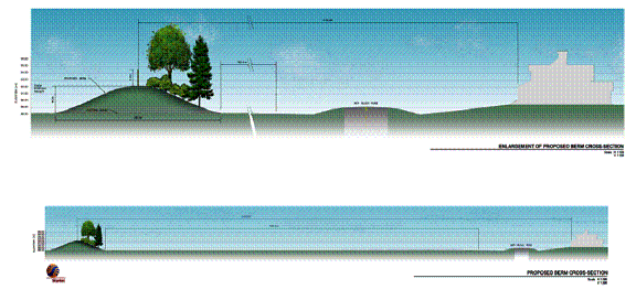
Figure 3. Proposed site cross section
showing berming, sound attenuation and naturalization features.
Council direction already exists to proceed with the proposed snow disposal facility at 2170 Mer Bleue Road, as confirmed in the OMB decisions previously discussed. However, parallel approval of the Mixed Use Designation and significant pressure from local interests suggest that specific clarification from Council regarding the future use of the site as an SDF is warranted. If the site is not to be used for an SDF, alternatives and impacts must be considered. These alternatives are described below.
Staff have explored numerous options for east end snow disposal, and present the following three for detailed consideration:
Option
1
Retain the site and construct the SDF. (Staff Recommendation)
Option
2
Abandon the site and look for an alternative site in the
area consistent with the 2002 SDF Scoping Report.
Option 3 Abandon the site and haul snow to other facilities in the Urban Core catchment area.
Option 1 is well understood since site acquisition and
zoning, all preliminary studies, a Class B environmental assessment, public
consultation, final design, and construction budget approval have all been
completed. The site is ready for
construction pending approval of the site plan by Council and a minor variance
by the Committee of Adjustment.
Option 2 requires more detailed analysis and
consideration since all previously identified alternative sites (from the 1990
study) are no longer available. A March
2007 review of the City land inventory in the catchment area found no alternate
site that would support an SDF, thereby necessitating the acquisition of
private property under Option 2. In
moving the SDF from 2170 Mer Bleue, a land acquisition cost would be
incurred. To account for this, and for
analysis purposes only, an average land cost for acquisition is estimated for
each of four zones (shown in Figure 4) based on sales activity over 2006-07 in
the East Urban Community. 10 year net
present value (NPV) cost estimates for developing and operating the Innes SDF
is compared with alternative sites in each zone are presented in Figure 5. Dollar amounts in Figure 5 are for
comparative purposes and omit the site construction cost that is assumed
constant for all sites. It is noted that costing and analysis for Option 2 is
conceptual only, since specific alternative sites are not identified.
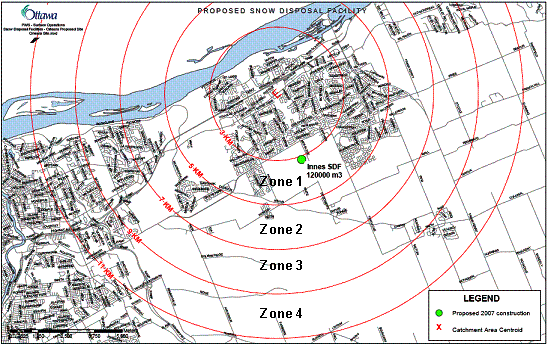
Figure 4. Zones developed to analyse potential costs associated
with Option 2. Alternative sites (not
identified) within each zone are assumed to have the same cost impact.
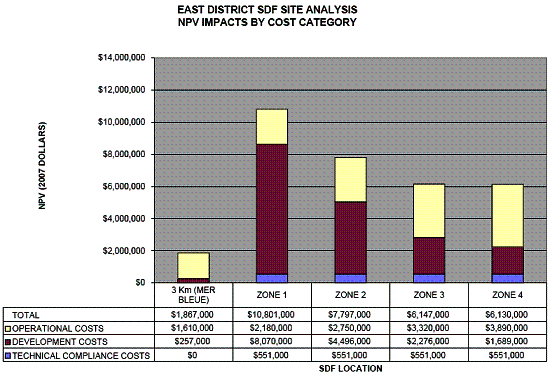
Figure 5. Option 2 cost analysis summary showing estimated 10
year net present value (NPV) for developing and operating the Innes SDF
compared with alternative sites in each zone.
Dollar amounts are for comparative purposes only and do not include
costs that are constant across all sites. .
Option 3, “abandon the site and haul snow to other facilities in the Urban Core catchment area”, would eliminate all snow disposal facilities from the East Urban Area. However, excess capacity does not exist in the Urban Core, as shown in Table 2. Recent closures in the Urban Core catchment include the Bayview SDF and Industrial SDF. Both Bayview and Industrial SDFs were identified as long-term sites and Council approved in 2002. As a result of these closures, a capacity deficit of 336,000 m3 exists in the Urban Area. Without another site in the urban core, diverting the east area’s snow to the urban SDFs would increase the urban SDF capacity shortfall and increase overall risk exposure.
In order to evaluate the relative merits of each of the three options, a number of decision criteria were established, including: cost, consistency with guiding documents and previous direction, environmental impact, and risk. The evaluation of options is summarized in Table 3.
Table 3. Summary of options analysis for East Urban snow disposal facility
Criteria |
Option 1 (2170 Mer Bleue) |
Option 2 (Alternative East-End Site) |
Option 3 (Haul to Urban Sites) |
Cost |
n $1.9M. Lowest cost option meeting design guidelines. n Minimum ongoing operating costs over the long term. |
n $6.1M to $10.8M Cost dependant primarily on site acquisition cost and distance. |
n Not estimated, but likely to be the most costly option by extension of analysis for Option 2. |
|
Consistency |
n Preferred site based on repeated and comprehensive analysis dating back to 1990. n Council approval of an SDF at this site in October 2002. |
n Removes SDF from Mixed Use Centre established in May 2003. |
n Removes SDF from Mixed Use Centre established in May 2003. |
|
Environment |
n Shortest haul distance. n Site design contains innovative features to mitigate visual and noise impacts on adjacent land use. |
n Potential for long haul distances, increased consumption of fossil fuels, increased generation of greenhouse gas and other emissions. |
n Long haul distances, increased consumption of fossil fuels, increased generation of greenhouse gas and other emissions. |
|
Risk |
n Very low risk since significant work has been completed including zoning, environmental assessment, public consultation, engineering design, and securing of funding. n Outstanding items include site plan approval and minor variance for setback distance. |
n High degree of risk since a suitable alternative site not identified. Previously identified alternatives have been developed for other uses. Alternative sites may not be feasible. n Service impacts possible during interim delay. |
n High degree of risk since existing urban sites cannot accommodate snow from East under design conditions. n Suitable additional site required but not identified. n Service impacts possible during interim delay. |
After
careful analysis, staff recommend Option 1 – that the proposed SDF proceed at
the current location of 2170 Mer Bleue Road for the following reasons:
§
It is the preferred site based on repeated
comprehensive analysis dating back to 1990 and approved by Council as recently
as October 2002.
§ It is the lowest cost option that meets established design guidelines.
§
It is the most environmentally responsible option
primarily due to relatively short haul distance, and also due to innovative
site layout and design features that mitigate many visual and noise impacts on
adjacent land uses.
§ It is the lowest risk option since the site is City-owned, and costs are well defined given the advanced stage of planning and design.
The City is currently in the late stages of negotiations with a local developer to execute a land exchange of 7.4 hectares of the Innes SDF buffer lands for 10 hectares of a nearby woodlot. The lands in question are shown on Figure 5. Details of this exchange are anticipated to be presented to Corporate Services and Economic Development Committee on April 3, 2007.

Figure 5. Approximate location and extent of properties involved
in proposed property exchange of woodlot (Tree Stand) for SDF buffer lands (2
SDF Parcels).
As noted in the background section of this report, the SDF lands involved in this land exchange were identified specifically to improve the integration of the SDF into future development. Future operational changes to the SDF will accommodate required snow disposal capacity on the reduced footprint.
Should the SDF not proceed at 2170 Mer Bleue Road, the site remains a viable property with access to the future expansion of Vanguard Drive. Nevertheless, land development on this parcel may warrant reconsideration.
Should Council recommend that the Innes SDF proceed, a minor variance to the setback distance will still be required. Since the previous request for a minor variance was initially granted by the Committee of Adjustment, then appealed, and finally reversed by the OMB, the two items that need to be addressed for granting of the minor variance are well understood. These two items are:
1.
Updating of the noise study using criteria of the current OP,
and incorporation of additional noise mitigation measures, if necessary; and
2. Dealing with the Mixed Use Centre designation of the site.
Updating the noise study and additional mitigation measures, if any are required, is anticipated to be a straightforward technical exercise.
The current Mixed Use Centre designation requires that development cannot proceed until completion of a Community Design Plan. As a Community Design Plan for the area has not yet been initiated, it can be anticipated that a delay of at least a year will occur prior to proceeding further with the SDF. This delay will introduce interim operating pressures until the site is built.
An Official Plan amendment to exempt the proposed SDF site from the Mixed Use Centre designation would provide relief from the requirement to complete a CDP prior to development of site and minimize further delays and impediments. Such an action would be consistent with previous direction from Transportation Committee, Planning and Environment Committee, and Council – all of which have previously approved the SDF at this location. An Official Plan amendment would demonstrate the clear intent of Council with respect to this site and eliminate one of the two reasons identified by the OMB for refusing the minor variance application.
Modifications to the Mixed Use Centre designation or the boundaries of the Mixed Use Centre have occurred during the development of CDPs, primarily to rationalize the boundary and provide an appropriate transition of uses. Both the Mer Bleue and East Urban Community CDPs contain modifications to the designation or its boundaries to reflect the approved CDPs.
The removal and disposal of snow from city streets, city sidewalks, and city facilities is a fundamental element of the City’s Winter Snow & Ice Control Program. It provides safe and passable transportation and transit networks for all users by reducing the hazards caused by snow and ice accumulation, while being environmentally responsible.
The development of snow disposal facilities in catchment areas significantly reduces trucking requirements with the associated reduction in consumption of fossil fuels and the generation of greenhouse gases and other emissions.
The development of “engineered” snow disposal facilities to contemporary standards in support of the City’s Winter Snow & Ice Control Program directly benefits the environment by containing melt water and allowing for a settling period prior to release to receiving waters.
Significant planning and engineering details have been incorporated into this site to mitigate and minimize visual and noise impacts on adjacent properties and land uses.
Planning and Infrastructure Approvals, Legal Services, Real Property Asset Management, and Infrastructure Services Branch have been consulted in the preparation of this report.
Extensive public consultations have occurred throughout the planning and development of the Innes SDF and the east urban Mixed Use Centre.
The
current site was acquired in 1991 for $1,500,000 along with preliminary scoping
studies of approximately $50,000.
In respect to the design and construction budget Council has approved authority of $3,950,000 of which $421,000 has been incurred or committed as a result of the EA processes and design. The balance of funding remaining to complete the project is $3,530,000 in capital accounts 903506 and 903745.
None
Upon approval of this report, the Public Works and Services Department will proceed with implementation of the recommendations.