Report
to/Rapport au :
Corporate Services and Economic Development Committee
Comité des services organisationnels
et du développement économique
and Council / et au Conseil
Submitted by/Soumis par : Greg Geddes, Chief Corporate Services Officer/
Contact
Person/Personne ressource : Gordon MacNair, Manager, Real Estate Services
Real Property Asset Management/Gestionnaire par
intérim, Services immobiliers, Gestion des biens immobiliers
(613) 580-2424 x 21217,
Gordon.Macnair@ottawa.ca
|
SUBJECT: |
|
|
|
|
|
OBJET : |
REPORT RECOMMENDATIONS
That the Corporate Services
and Economic Development Committee recommend Council:
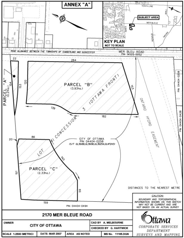
1. Declare three parcels of vacant land, consisting of approximately
6.47 ha (15.99 ac), having a value of $959,400, described as being Parts of Lot
1, Concession 3, Ottawa Front, geographic Township of Gloucester, now in the
City of Ottawa, as shown hatched on Annex “A” attached, as surplus to the
City's needs;
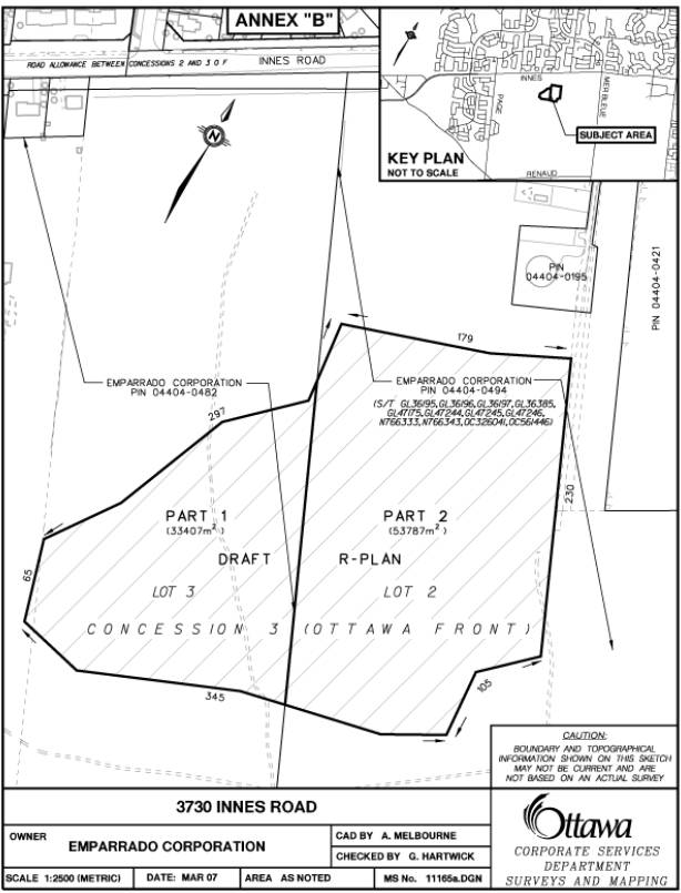
2. Approve the acquisition of one parcel of vacant land, consisting of
approximately 8.72 ha (21.54 ac), described as being Part of Lot 3, Concession
2, Ottawa Front, geographic Township of Gloucester, now in the City of Ottawa
as shown on Annex “B”attached, having a value of $1,292,400 from Emparrado
Corporation, in exchange for the land detailed in Recommendation 1, subject to
final surveys and any easements that may be required, plus the sum of $350,861, being the agreed compensation for
the difference in the value of the lands being exchanged, pursuant to a Land
Exchange Agreement that has been received.
RECOMMANDATIONS DU
RAPPORT
Que le Comité des
services organisationnels et du développement économique recommande au
Conseil :
1. De
déclarer excédentaires, par rapport aux besoins de la Ville, trois terrains
vacants d’une superficie totale approximative de 6,47 ha (15,99 acres), ayant
une valeur de 959 400 $ et décrits comme des parties du lot 1,
concession 3, façade rivière des Outaouais, canton géographique de Gloucester,
maintenant situés sur le territoire de la ville d’Ottawa, et illustrés par la
partie hachurée de l’annexe “A”.
2. D’approuver
l’acquisition, auprès de Emparrado Corporation, d’un terrain vacant d’une
superficie approximative de 8,72 ha (21.55 acres), décrit comme une partie du
lot 3, concession 2, façade rivière des Outaouais, canton géographique de
Gloucester, maintenant situé sur le territoire de la ville d’Ottawa, illustré à
l’annexe “B” et ayant une valeur de 1,292,400 $, en échange des terrains
décrits à la recommandation 1, sous réserve des levés définitifs et des
servitudes pouvant être requises, plus la somme de 350,861 $, constituant
l’indemnité convenue pour la différence de valeur des terrains échangés,
conformément à l’entente d’échange de terrains qui a été reçue.
BACKGROUND
The City of Ottawa's Official Plan designates natural areas in the rural and urban area, that have high environmental value and that are intended for conservation purposes. It is the intention of natural environment areas policies, to preserve significant natural features and associated ecological functions for the long term. Urban Natural Features provide a valuable contribution to biodiversity and wildlife habitat in the urban area, and are enjoyed by residents. These Features are designated on Schedule B of the Official Plan. The woodland that is the subject of this report, is located in the former City of Gloucester and is in the process of being designated Urban Natural Feature in the City's Official Plan as part of a settlement of an appeal to the 2003 Official Plan. At the time of writing this report, Planning and Environment Committee had approved the settlement, including the designation of the woodlot as Urban Natural Feature. The item is on the 28 March 2007 Council agenda. The change to the Official Plan would be done as a modification by the Ontario Municipal Board at a hearing scheduled for 23 April 2007. The land is currently under private ownership.
The existing City property being proposed as part of this land exchange was initially acquired in 1991 for use as a snow disposal facility (SDF) to service the long-term needs of the East Urban Area. In an effort to more effectively integrate the SDF with local land use, the footprint of the proposed SDF was significantly reduced freeing most of the arterial frontage for other uses. These perimeter portions of the SDF property are being considered in this land exchange and are shown in the diagram on Annex “A”. Should the SDF not be constructed as currently planned, the remaining parcel on the property will become available for other uses. Surface Operations Branch will be presenting a report to Transportation Committee on 4 April 2007 seeking final direction regarding the use of the property as a snow disposal facility.
The subject woodland was recently examined and evaluated through the Council approved Urban Natural Areas Environmental Evaluation Study (March 2005 and 2006). The Urban Natural Areas Environmental Evaluation Study (UNAEES) assessed the relative environmental value of the remaining 192 natural areas in the urban area.
The subject woodlands, identified as Innes Park Woods (UNA #87) in the UNAEES, received an overall rating of Moderate environmental value, confirming their local environmental significance. These woodlands are also included in the Council approved Greenspace Master Plan (June 2006) and are a component of the City's natural lands inventory. The woodland is owned by Emparrado Corporation.
In keeping with the policies of the 2003 Official Plan, as amended where land designated Urban Natural Feature is in private ownership, the City will acquire the land when requested to do so by the owner. This is necessary to protect the sites from development.
DISCUSSION
At the request of the Planning Transit and the Environment Department, Environmental Sustainability Division, negotiations with the Emparrado Corporation were undertaken to acquire the Innes Park Woods. The subject property is located south of Innes Road, west of the Belcourt Blvd. extension in Ward 2, Innes.
The Innes Park Woods contain three habitats:
o fissured limestone bedrock flats under open regenerating Red Maple, Staghorn Sumac, White Elm;
o mature upland deciduous forest dominated by Sugar Maple cover in eastern half of site;
o younger upland deciduous forest (White Ash, Sugar Maple canopy) in western half of site.
The mature maple forest is an
excellent example of high canopy maple forest with high recreational/aesthetic
potential on a neighbourhood scale. The
limestone rockflat habitat is rare in the urban area of Ottawa.
As part of the Acquisition strategy for the Innes Park Woods, owned by Emparrado Corporation, staff is proposing a land exchange involving the remainder of the City-owned parcel of vacant land originally purchased for the Mer Bleue Snow Disposal Facility.
The three City parcels, shown on Annex "A", consist of 6.47 ha (15.99 acres) and are zoned Heavy Industrial (Mx). The properties are municipally known as 2170 Mer Bleue Road and are located south of Innes Road on the west side of Mer Bleue Road. The properties are vacant cleared land.
The Emparrado lands as outlined on Annex “B”, consist of 8.72 ha (21.54 acres) of vacant land, which, are currently, zoned Industrial. These lands are part of a larger site which encompass 68 ha (152.01 acres). As well, there is an application to rezone the Innes frontage Commercial in line with the amended Official Plan.
Appraisals confirmed that both parcels had similar development potential based on a highest and best use analysis, which resulted in an market value estimate of $ 60,000/ac at the date of settlement. This is summarized as follows:
|
Emparrado Lands |
21.54 ac |
$ 60,000/ac |
$ 1,292,400 |
|
City Owned Parcel |
15.99 ac |
$ 60,000/ac |
$ 959,400 |
|
Difference |
|
|
$ 333,000 |
The funding for the difference of $ 333,000 is identified under the Financial Implications of this report.
As part of this Agreement, Emparrado Corporation has agreed to convey to the City at no cost, the Official Plan road widening requirement for Mer Bleue Road containing approximately 3420 m2.
ENVIRONMENTAL IMPLICATIONS
The City lands recommended to be transferred to Emparrado Corporation does not involve any identified natural environment or greenspace lands. The proposed lands to be acquired contain a woodlot that is designated as Urban Natural Features. Urban Natural Features are recognized areas of importance in the urban landscape. They contribute significantly to public health, community enjoyment, and property values. They provide remnant areas of natural vegetation and habitat in the urban area, that residents enjoy and value. Securement of the woodlands in City ownership is consistent with the City's Official Plan, the Environmental Strategy, and the Greenspace Master Plan.
In the Greenspace Appeals report to Planning and Environment Committee on 24 May 2005, City staff presented proposed policy modifications to the Official Plan, in regards to the acquisition of land in the Natural Environment Area, Urban Natural Features and the Major Open Space designations. In carrying the recommendation on 8 June 2005, Council agreed to secure lands in the Urban Natural Features designation, through acquisition if necessary. In keeping with the Official Plan policy, staff is recommending that Council approve the acquisition of the Urban Natural Feature, being the Innes Park Woods, by a combination of land exchange and monetary consideration, as detailed in Recommendations 1 and 2 of this report. Protection of these properties is consistent with Ottawa 20/20 guiding principles of:
1) a Green and Environmentally Sensitive City;
2) a City of Distinct, Liveable Communities;
3) a Responsible and Responsive City;
4) a Healthy and Active City.
The City will obtain a Phase I ESA, as part of its due diligence process.
CONSULTATION
The Environmental Sustainability Division, Development Approvals Division, and Surface Operations have been consulted.
In accordance with policies approved by City Council on 14 November 2001, the availability of the City-owned property recommended for exchange were circulated to all client City Departments, including the Housing Branch, Public Works and Services and Planning, Transit and the Environment, to determine if the parcel should be retained for a City mandated program. External Agencies and Utility companies were also circulated.
The following Advisory Committees have been circulated:
Local Architectural Conservation Advisory Committee
Ottawa Forests and Greenspace Advisory Committee
Environmental Advisory Committee
Parks and Recreation Advisory Committee
Roads and Cycling Advisory Committee
Rural Issues Advisory Committee
Pedestrian and Transit Advisory Committee
Circulation comments have not
been received at the time of writing this report, however any objections to the
disposal of this property received through the circulation process, will be
reported to Corporate Services and Economic Development Committee, when this
report is considered.
The ward Councillor has been made aware of the land exchange and supports staff‘s recommendations.
HOUSING FIRST POLICY
The Official Plan policy directs that the City make land available for affordable housing and give priority for the sale or lease of surplus City-owned property for this purpose.
The Housing First Policy, approved by Council on 13 July 2005, establishes priority consideration to the Housing Branch in the identification of potentially surplus City-owned property to be used in achieving the City’s affordable housing program targets. The policy also requires that the Official Plan target of 25% affordable housing, be met on any City-owned property sold for residential development. Where viable residential properties are disposed of without a condition requiring an affordable housing component, 25% of the proceeds from the sale are to be credited to a housing fund to be used for the development of affordable housing elsewhere in the City.
None of the subject properties are zoned for residential use so there is no impact on the Housing First Policy
FINANCIAL IMPLICATIONS
The total value of the Emparrado lands to be conveyed to the City is $ 1,292,400. The total value of the City lands to be conveyed to Emparrado is $ 959,400, an amount that will be credited as a cost avoidance credit to the Surplus Lands account. A cash payment of $ 333,000 to make up the difference will be paid to Emparrado, on the closing date plus land transfer tax of $ 17,861 for the value of the land acquired by the City for a total of $ 350,861.
Funds in the amount of $ 350,861 are available in internal
order #904330, Natural Area Acquisition.
SUPPORTING DOCUMENTATION
Attached as Annex “A”, is a sketch showing the City lands, and Annex "B" showing the Innes Park Woods, being the properties proposed for exchange.
DISPOSITION
Following approval, Real Property Asset Management and Legal Services Branches will finalize this transaction. Surveys and Mapping to complete a survey of City lands, to be conveyed to Emparrado Corporation.
ANNEX A
ANNEX B