|
13. JOCK
RIVER REACH 1 SUBWATERSHED STUDY AND BARRHAVEN SOUTH MASTER SERVICING STUDY ÉTUDE SUR LE SOUS-BASSIN HYDROGRAPHIQUE DU TRONÇON 1 DE LA RIVIÈRE
JOCK ET ÉTUDE SUR LE PLAN DIRECTEUR DE VIABILISATION DE BARRHAVEN SUD |
Committee recommendationS
That Council:
1. Approve
the Jock River Reach 1 Subwatershed Study (Stantec, January 2007).
2. Approve
the Barrhaven South Conceptual Fish Habitat Compensation Plan (Niblett, January
2007) and the use of City land known municipally as 3300 Cedarview Road for the
creation of new fisheries habitat area.
3. Approve
the recommended projects identified in the Barrhaven South Master Servicing
Study prepared by Stantec, illustrated in Document 4, in accordance with the
requirements of the Ontario Environmental Assessment Act.
4. Direct
Planning, Transit and Environment staff to finalize the Barrhaven South Master
Servicing Study and proceed with the 30-day public review period, in accordance
with the Ontario Environmental Assessment Act and as a prelude to the
initiation of the detailed design.
RecommandationS du Comité
Que le Conseil municipal approuve :
1. L’étude
sur le sous-bassin hydrographique du tronçon 1 de la rivière Jock (Stantec,
janvier 2007);
2. Le Plan de compensation conceptuel sur l’habitat du poisson
de Barrhaven Sud (Niblett, janvier 2007) et l’utilisation des propriétés de la
Ville situées au 3 300, chemin Cedarview, pour la création d’une nouvelle zone
d’habitat du poisson;
3. Les projets recommandés indiqués dans l’étude sur le Plan directeur
de viabilisation de Barrhaven Sud préparée par Stantec et illustrée dans le
Document 4, conformément aux exigences de la Loi sur l’évaluation
environnementale de l’Ontario;
4.
Demande
au personnel d’Urbanisme, Transport en commun et Environnement de finaliser
l’étude sur le Plan directeur de viabilisation de Barrhaven Sud et d’aller de
l’avant avec la période d’examen public de 30 jours, conformément à la Loi sur
l’évaluation environnementale de l’Ontario et à titre de prélude au lancement
de la conception détaillée.
Documentation
1.
Deputy
City Manager's report Planning,
Transit and the Environment dated
24 January 2007 (ACS2007-PTE-POL-0004).
Report
to/Rapport au :
Planning and Environment Committee
Comité de l'urbanisme et de
l'environnement
and Council / et au Conseil
24 January 2007 / le 24 janvier 2007
Submitted by/Soumis par : Nancy Schepers, Deputy City Manager/
Directrice municipale adjointe,
Planning, Transit and Environment/Service de l'urbanisme, du transport
en commun et de l'environnement
Contact
Person/Personne ressource : Dennis Jacobs, Director
Planning, Environment and Infrastructure
Policy/Politiques d’urbanisme, d’environnement et d’infrastructure
(613) 580-2424 x 25521,
Dennis.Jacobs@ottawa.ca
REPORT RECOMMENDATION
That Planning and Environment Committee
recommend City Council:
1. Approve
the Jock River Reach 1 Subwatershed Study (Stantec, January 2007).
2. Approve the Barrhaven South Conceptual Fish Habitat Compensation Plan (Niblett, January 2007) and the use of City land known municipally as 3300 Cedarview Road for the creation of new fisheries habitat area.
3. Approve the recommended projects identified in the Barrhaven South Master Servicing Study prepared by Stantec, illustrated in Document 4, in accordance with the requirements of the Ontario Environmental Assessment Act.
4. Direct Planning, Transit and Environment staff to finalize the Barrhaven South Master Servicing Study and proceed with the 30-day public review period, in accordance with the Ontario Environmental Assessment Act and as a prelude to the initiation of the detailed design.
RECOMMANDATION DU RAPPORT
Que le Comité de l’urbanisme et de
l’environnement recommande au Conseil municipal :
1. d’approuver
l’étude sur le sous-bassin hydrographique du tronçon 1 de la rivière Jock
(Stantec, janvier 2007);
2. d’approuver
le Plan de compensation conceptuel sur l’habitat du poisson de Barrhaven Sud
(Niblett, janvier 2007) et l’utilisation des propriétés de la Ville situées au
3 300, chemin Cedarview, pour la création d’une nouvelle zone d’habitat du
poisson;
3. d’approuver
les projets recommandés indiqués dans l’étude sur le Plan directeur de
viabilisation de Barrhaven Sud préparée par Stantec et illustrée dans le
Document 4, conformément aux exigences de la Loi sur l’évaluation
environnementale de l’Ontario;
4. de
demander au personnel d’Urbanisme, Transport en commun et Environnement de
finaliser l’étude sur le Plan directeur de viabilisation de Barrhaven Sud et
d’aller de l’avant avec la période d’examen public de 30 jours, conformément à
la Loi sur l’évaluation environnementale de l’Ontario et à titre de prélude au
lancement de la conception détaillée.
EXECUTIVE SUMMARY
Assumptions and Analysis:
The
Barrhaven South Community Design Plan (CDP) was approved by City Council on
June 28, 2006. One of the approved
recommendations directed staff to bring forward for approval the required
Subwatershed Study for the Jock River Reach 1, the Conceptual Fish Habitat
Compensation Plan, and the Master Servicing Study. These supporting studies
have now been completed and are the subject of this report for approval.
The
City of Ottawa and the principal landowners within Barrhaven South undertook
the following technical studies, as co-proponents, following the Class
Environmental Assessment (EA) process in support of the Barrhaven South
Community Design Plan:
· Jock
River Reach 1 Subwatershed Study (January 2007)– Stantec Consulting Ltd.,
Niblett Environmental Associates Inc., Parish Geomorphic
· Barrhaven
South Conceptual Fish Habitat Compensation Plan (January 2007) – Niblett Environmental
Associates Inc.
· Barrhaven
South Master Servicing Study - Stantec Consulting Ltd.
The
subwatershed study has developed a stormwater management and natural
environment plan for north of the Jock River, south of the Jock River and the
Jock River Corridor to assist with future studies and development
requirements. The Barrhaven South
Conceptual Fish Habitat Compensation Plan (CFCP) identifies fish habitat
restoration and enhancement measures to address the fish habitat losses
associated with the development of Barrhaven South. The Barrhaven South Master Servicing Study has identified an
internal servicing scheme for water, sanitary, storm drainage and stormwater
management servicing that supports the land uses and development densities
approved through the Barrhaven South Community Design Plan. The following infrastructure projects have
been recommended for the Barrhaven South development area following the Class
EA process for Schedule B undertakings:
· Wastewater
collection system
· Water
distribution system
· Enclosure/partial
enclosure of four watercourses (Todd, East Clarke, West Clarke and Corrigan
municipal drains/tributaries)
· Construction of three stormwater detention facilities and associated storm drainage collection systems, including:
o Corrigan
SWM Pond and associated storm sewers (Schedule B)
o Todd
SWM Pond and associated storm sewers (Schedule B)
o Clarke
SWM Pond and associated storm sewers (Schedule B)
The
Master Servicing Study has also identified constraints that will influence the
storm drainage servicing of the site.
Subsurface investigations have identified soil conditions (compressible
silty clays) which limit the extent to which the site may be raised. Preliminary design completed for the Master
Servicing Study has assumed a maximum grade raise of 1.5 meters, however,
further detailed geotechnical investigations will be required during detailed
design to confirm the permissible grade raise. and to determine the extent to
which practices such as pre-loading or surcharging will be required to safely
accommodate the proposed grade raise. Such measures will require additional
time to prepare the site for servicing.
Given
the low lying areas in the northern portion of the study area and the grade
raise restrictions noted above, much of the storm sewer system will have
minimal cover and a portion of the system will be subject to permanent standing
water. These conditions will preclude
the use of standard depth basements over a significant portion of the study
area.
The
approval of these technical studies will facilitate the processing and approval
of development applications in the area.
Financial Implications:
The
majority of projects identified in the technical studies will be financed
through Development Charges, developers or existing programs through Council’s
budgetary approval process.
Site constraints arising from soil conditions that limit grade raises in combination with low lying areas over a large portion of the site will result in permanent standing water in a significant portion of the storm sewer system. This will result in signficantly increased costs to the City to own, operate and maintain the affected sewers due to the need for regular pumping to draw down the sewers and/or other measures to manage the increased potential for sedimentation in the pipes.
Public Consultation/Input:
The
consultation program fulfilled the consultation requirements specified in the
Municipal Engineers Association Class Environmental Assessment document for
Schedule B projects. A total of four
open houses/ workshops were conducted at key project milestones. Individual and collective meetings with
other City staff, Rideau Valley Conservation Authority, and provincial and
federal agencies to discuss technical requirements and comments were held on
numerous occasions throughout the development of both studies.
The Barrhaven South Master Servicing Study will be finalized after City Council approves the recommended projects (Recommendation 3). Notices of Completion will be published for both the Subwatershed Study and Master Servicing Study notifying the public of the availability of the reports and the 30-day public review period.
RÉSUMÉ
Hypothèses et analyse :
Le 28 juin 2006, le Conseil municipal
a approuvé le Plan de conception communautaire (PCC) de Barrhaven Sud. Dans une
des recommandations approuvées, on demandait au personnel de présenter pour
fins d’approbation l’étude sur le sous-bassin hydrographique requise pour le tronçon 1
de la rivière Jock, le Plan de compensation conceptuel sur l’habitat du poisson
et l’étude sur le Plan directeur de viabilisation. Ces études complémentaires
sont maintenant terminées et font l’objet du présent rapport qui doit être
approuvé.
La Ville d’Ottawa et les principaux
propriétaires de Barrhaven Sud ont entrepris les études techniques suivantes, à
titre de coproposants, à la suite du processus d’évaluation environnementale
(ÉE) de portée générale à l’appui du Plan de conception communautaire de
Barrhaven Sud :
. Étude
sur le sous-bassin hydrographique du tronçon 1 de la rivière Jock
(janvier 2007) – Stantec Consulting Ltd., Niblett Environmental
Associates Inc., Parish Geomorphic;
. Plan
de compensation conceptuel sur l’habitat du poisson de Barrhaven Sud
(janvier 2007) – Niblett Environmental Associates Inc.;
. Étude
sur le Plan directeur de viabilisation de Barrhaven Sud – Stantec
Consulting Ltd.
Dans le cadre de l’étude sur le sous-bassin
hdrographique, on a établi un plan d’environnement naturel et de gestion des
eaux pluviales pour le nord de la rivière Jock, le sud de la rivière Jock et le
corridor de la rivière Jock pour aider aux études futures et aux besoins
d’aménagement. Le Plan de compensation conceptuel sur l’habitat du poisson de
Barrhaven Sud soulève les mesures d’amélioration et de restauration de
l’habitat du poisson à prendre pour remédier aux pertes de l’habitat du poisson
associées à l’aménagement de Barrhaven Sud. Dans le cadre de l’étude sur le
Plan directeur de viabilisation de Barrhaven Sud, on a déterminé un plan de
service interne pour les services publics d’eau, d’égouts sanitaires et
pluviaux et de gestion des eaux pluviales, lequel appuie l’utilisation des
terrains et les espaces d’aménagement approuvés par le Plan de conception
communautaire de Barrhaven Sud. Les projets d’infrastructure suivants ont été
recommandés pour la zone de développement de Barrhaven Sud à la suite du
processus d’ÉE de portée générale pour les initiatives de
l’annexe B :
. réseau
de collecte des eaux usées;
. réseau
de distribution d’eau;
. isolement/isolement
partiel de quatre cours d’eau (drains municipaux/affluents de Corrigan, Todd,
East Clarke, West Clarke);
. construction
de trois installations de retenue des eaux pluviales et de réseaux connexes de
collecte et de drainage des eaux pluviales, y compris :
○
le
bassin de GEP Corrigan et les égouts pluviaux connexes (annexe B),
○
le
bassin de GEP Todd et les égouts pluviaux connexes (annexe B),
○
le
bassin de GEP Clarke et les égouts pluviaux connexes (annexe B).
Dans l’étude sur le Plan directeur de
viabilisation, on a également déterminé les contraintes qui influenceront les
services publics de drainage pluvial du site. Les études souterraines ont
permis de déceler les conditions du sol (argile limoneuse compressible) qui
limitent la mesure dans laquelle l’emplacement peut être soulevé. Une fois la
conception préliminaire terminée pour l’étude sur le Plan directeur de
viabilisation, on a présumé une élévation maximale du niveau de 1,5 mètre.
Toutefois, d’autres études géotechniques détaillées seront nécessaires pendant
la conception détaillée afin de confirmer l’élévation admise du niveau et de
déterminer la mesure dans laquelle les pratiques comme le préchargement ou le
surchargement seront nécessaires pour réaliser en toute sécurité l’élévation
proposée du niveau. De telles mesures nécessiteront plus de temps pour préparer
l’emplacement pour les services.
Étant donné les régions basses dans la partie
nord de la zone d’étude et les restrictions quant à l’élévation du niveau
susmentionnées, le réseau d’égouts pluviaux sera en grande partie peu couvert
et une partie du réseau sera assujettie à des eaux dormantes permanentes. Ces
conditions empêcheront l’utilisation des sous-sols de profondeur standard dans
une importante partie de la zone d’étude.
L’approbation de ces études techniques
facilitera le traitement et l’approbation des demandes d’aménagement dans le
secteur.
Répercussions financières :
La majorité des projets soulevés dans les études
techniques seront financés par les redevances d’aménagement, les promoteurs ou
les programmes actuels, conformément au processus d’approbation des budgets du
Conseil.
Les contraintes du site découlant des
conditions du sol qui limitent les élévations du niveau en combinaison avec les
régions basses sur une grande partie du site auront pour conséquence la
présence d’eaux dormantes permanentes dans une importante partie du réseau
d’égouts pluviaux. Cela entraînera une augmentation considérable des coûts à la
Ville pour acquérir, faire fonctionner et entretenir les égouts touchés en
raison du besoin d’un pompage régulier pour abaisser le niveau des égouts et/ou
d’autres mesures pour gérer la possibilité accrue d’une sédimentation dans les
tuyaux.
Consultation publique / commentaires
:
Le programme de consultation a répondu aux
besoins de consultation précisés dans le document de l’évaluation
environnementale de portée générale de la Municipal Engineers Association pour
les projets de l’annexe B. Au total, quatre consultations
publiques/ateliers ont été tenus à des étapes marquantes du projet. On a
organisé à plusieurs occasions tout au long du développement des études des
réunions individuelles et collectives avec d’autres membres du personnel de la
Ville, l’Office de protection de la nature de la vallée Rideau et des
organismes provinciaux et fédéraux afin de discuter des exigences techniques et
des commentaires reçus.
L’étude sur le Plan directeur de viabilisation
de Barrhaven Sud sera finalisée une fois que le Conseil municipal aura approuvé
les projets recommandés (Recommandation 3). Des avis d’achèvement seront
publiés pour l’étude sur le sous-bassin hydrographique et l’étude sur le Plan
directeur de viabilisation informant le public de la disponibilité des rapports
et de la période d’examen public de 30 jours.
BACKGROUND
Barrhaven
South is an area of approximately 500 hectares in size located in the southern
end of the urban area of Ottawa, as illustrated in Document 1. The Barrhaven South study area is defined by
the Jock River to the north, Highway 416 to the west, Jockvale Road and
Greenbank Road to the east, and the urban area boundary to the south. Barrhaven South is west of, and adjacent to,
the developing community of Stonebridge, and is south of the South Nepean Town
Centre. In January 2005, a consultant
team, working on behalf of the principal landowners within the Barrhaven South
boundary, in concert with the Planning, Transit and Environment Department,
initiated the Barrhaven South Community Design Plan (CDP). As part of the development of the CDP, the
Jock River Reach 1 subwatershed, transportation master plan and master
servicing studies were undertaken to identify the environmental, roadway,
transit and infrastructure servicing requirements to guide and support the
preferred land use plan. All of these
technical studies followed the Municipal Engineers Association (MEA) Class
Environmental Assessment process.
The
Barrhaven South Community Design Plan (CDP) and Transportation Master Plan were
completed and approved by Council in June 2006
(http://ottawa.ca/calendar/ottawa/citycouncil/pec/2006/06-13/ACS2006-PGM-POL-0042.htm). The subwatershed and master servicing
studies were not finished at that time.
Council approved staff's recommendation to bring forward the master
servicing study, the subwatershed study for Reach 1 of the Jock River and
conceptual fish compensation plan for Council approval. Council approved Recommendation 4 of the
Barrhaven South Community Design Plan Report that directed Legal Services to
bring forward the Barrhaven South draft Official Plan Amendment implementing
by-law to City Council for approval once the three studies had received City
Council approval.
The
Jock River Reach 1 Subwatershed Study and Barrhaven South Conceptual Fish
Habitat Compensation Plan have now been completed (Document 2, distributed
under separate cover) and as per Recommendations 1 and 2 of this report,
approval of these documents are recommended.
As per Recommendation 3 of this report, staff recommends approval of the
wastewater, water, storm drainage and stormwater management projects identified
through the Barrhaven South Master Servicing Study (Document 4). The
approval of these technical studies will allow for the Official Plan Amendment
to proceed to Council, facilitating the processing and approval of development
applications in the Barrhaven South area.
The purpose of this report is to provide a summary of the study process that
lead to the environmental and infrastructure servicing recommendations.
DISCUSSION
The
Jock River Reach 1 Subwatershed Study and Barrhaven South Master Servicing
Study followed an integrated planning approach such that the environmental and
preliminary servicing requirements were identified and integrated into the
development of the preferred land use plan for Barrhaven South. Detailed analysis was then undertaken based
on the preferred concept plan to sufficiently define the environmental and
infrastructure servicing requirements consistent with applicable policies,
regulations and engineering standards.
Although separate documents have been produced, the technical studies
were planned and coordinated as an integrated master planning exercise.
The
City of Ottawa and the principal landowners within Barrhaven South are
co-proponents for the required Class Environmental Assessments. The subwatershed and master servicing
studies have completed Phases 1 and 2 of the MEA Class Environmental Assessment
process following the Master Plan approach.
The subwatershed study followed “Approach #1” of the Master Planning
approach whereby a broad level of assessment has been undertaken such that
projects identified would require further assessment under the Class EA. The Master Servicing Study followed
“Approach #2” whereby the level of assessment, consultation and documentation
are sufficient to fulfill the requirements for Schedule B projects. Following the posting of the Notice of
Completion and the conclusion of the 30-day public review period, all Class EA
requirements will have been met and the identified projects may proceed to
detailed design and construction.
For
the area north of the Jock River, the conceptual stormwater management option
identified in the subwatershed study would be subject to completing the EA
requirements and approvals in the future.
A
summary of the study methodology, analysis and recommendations associated with
the three technical studies is provided below.
Jock
River Reach 1 Subwatershed Study
The
Barrhaven South community falls within Reach 1 of the Jock River subwatershed
area. The subwatershed boundary is
larger than the CDP area as it follows a natural drainage area boundary. Document 1, Study Area Figure, illustrates
the subwatershed boundary that includes lands north of the Jock River within
the existing Barrhaven community and adjacent vacant urban lands, east of
Highway 416. The subwatershed has a
total area of approximately 2,300 hectares, one half of which is already
developed. The majority of the
subwatershed is in the urban area with approximately 711 ha of vacant land
located north of the Jock River and approximately 360 ha vacant land situated
south of the Jock River.
The
Jock River Reach 1 subwatershed study provides the environmental and conceptual
stormwater management requirements for the Barrhaven South community and the
undeveloped urban lands north of the Jock River, straddling Strandherd
Drive. The management strategy aims to
protect, restore or enhance the significant natural features and functions
identified in the subwatershed while accommodating development, over the
long-term. As part of the subwatershed
study, a Conceptual Fish Habitat Compensation Plan (CFCP) has been prepared to
identify fish habitat restoration and enhancement measures to address the fish
habitat losses associated with the development of Barrhaven South.
The
Jock River Reach 1 subwatershed planning process was comprised of four main
phases: 1) Characterization of Existing Environmental Conditions; 2)
Establishment of Subwatershed Goals and Objectives; 3) Development of the
Preferred Management Strategy; and, 4) Implementation Strategy. Reach One of the Jock River falls within the
Rideau River watershed. The Council
approved Lower Rideau River Watershed Strategy
(http://ottawa.ca/calendar/ottawa/citycouncil/pec/2006/10-24/ACS2006-PGM-POL-0080.htm)
was a guiding document in the development of the subwatershed plan. The main phases and outcome of the subwatershed
process are summarized below.
Existing
Environment Conditions
The
existing natural resources within the subwatershed were identified and assessed
to determine significant features and functions within the study area. Investigations were conducted in the areas
of hydrology, terrestrial, aquatic, water quality, fluvial geomorphology, and
hydrogeologic resources. The level of
detail differed for lands north and south of the Jock River, in that more
detailed field investigations and analysis were undertaken for the lands south
of the Jock River in association with the Barrhaven South Community Design
Plan.
Document
3, Environmental Constraints and Opportunities map and key findings,
illustrates the important natural features within the subwatershed, such as
woodlands and watercourses. Key
environmental findings are highlighted below and summarized in Document 3:
Tributaries:
· North
of the Jock River, the main tributaries are O’Keefe Drain, Foster Ditch and
Fraser Clarke Drain.
· South
of the Jock River, the main tributaries are the West Clarke Drain, East Clarke
Drain, Todd Drain and Corrigan tributary.
· All tributaries to the Jock River support fisheries and are considered fish habitat.
· The
tributaries provide only a highly seasonal and marginal fish habitat for a
handful of warm water tolerant fish species.
Terrestrial
Resources:
· A
total of 28 woodlands exist in the subwatershed. A total of nine woodlands were identified as significant
consistent with the findings of the Urban Natural Areas Environmental
Evaluation Study. These include Urban
Natural Areas #49 (W7), #50 (W44), #57 (W1 W2), #58 (W10), #60 (W43), #183
(W50).
· Significant
species reported or observed include one federal (butternut), one provincial
(greater redhorse fish species) and fourteen regionally rare species.
Jock
River:
· Jock
River is highly productive fisheries resource that contains healthy populations
of naturally reproducing game fish such as muskellunge.
· A
number of important and/or critical fish habitat areas within the main stem of
the Jock River have been identified within Reach 1.
· Jock
River water quality is highly impaired and does not meet provincial water
quality criteria.
· The
Jock River is classified as a Policy 2 watercourse for phosphorus, which
requires a net reduction in phosphorus loadings to the river.
· Through
the fluvial geomorphology investigation, the meander belt width was determined
for the Jock River corridor representing the maximum lateral extent of the
channel over time. Meander belt is
considered a hazard constraint that needs to be considered in establishing
development setbacks from the river.
The
environmental constraints and opportunities map was used to develop land use
concept alternatives for Barrhaven South.
The Jock River corridor, its floodplain, two tributaries and the two
significant woodlands were identified for protection. The environmental features were used to plan and integrate the
parks, open space and stormwater management facilities forming the greenspace network
for the community. Built form and
layout design were then developed in concert with the greenspace network
ensuring compatibility with natural attributes of the area.
Jock
River Reach 1 Management Strategy
Evaluation
and assessment of the various natural resource components of the subwatershed
were conducted to understand and identify the important features and functions
occurring in the subwatershed.
This
holistic understanding of the health and state of the subwatershed’s ecosystem
has led to the preparation of the preferred management strategy for the areas
north and south of the Jock River. The
Jock River Reach 1 management strategy consists of three main components:
Conceptual Stormwater Management Plan; Natural Environment Plan and Conceptual
Fish Habitat Compensation Plan.
Stormwater
Management Design Criteria
Following
the analysis of the existing condition of the subwatershed and a series of
detailed hydrologic assessments, the criteria for the management of urban
runoff were established. All future
stormwater management facilities within Reach 1 must comply with the stormwater
management design criteria summarized below.
Jock
River:
· No
quantity control storage required for flood control purposes as the hydrograph
from the subwatershed will peak before the upstream peak in the Jock River.
· No
erosion control storage required to maintain the predevelopment in-stream
erosion condition.
· Quality control storage as per the Ministry of Environment Enhanced Treatment (80% TSS removal), following the integrated SWM approach recommended in the Lower Rideau Watershed Strategy.
North of the Jock River - criteria for stormwater management facilities:
· Quantity control storage as required to meet constraints within existing channels and/or at existing crossings (quantity control/level of control to be determined through further detailed study).
· Erosion control storage as required to maintain stability and geomorphic function of the existing tributaries, as determined through further detailed study.
· Quality control storage as per the Ministry of Environment Enhanced Treatment (80% TSS removal).
· All stormwater management facility outlets will be designed to augment low flows to the extent possible.
South
of the Jock River - criteria for stormwater management facilities:
· Quantity control storage as required
by the capacity of rehabilitated tributaries.
· No erosion control storage required; rehabilitated tributaries to be designed to withstand the erosive impulse of stormwater runoff.
· Quality control storage as per the Ministry of Environment enhanced level treatment (80% TSS removal).
· All stormwater management facility outlets will be designed to augment low flows to the extent possible.
Subwatershed
Water Balance:
· Implement structural infiltration practices (e.g. infiltration trenches) in areas of suitable soil; implement non-structural best management practices (e.g. reduced grading, disconnected impervious areas, promotion of open space and park lands, maximizing vegetative cover) elsewhere in the system to reduce magnitude of runoff volume.
Additional
analysis was conducted to the satisfaction of the Ministry of Environment that
demonstrated the combination of urbanization and stormwater treatment will
reduce net loading of phosphorus to the Jock River.
Evaluation
of Stormwater Management Options
A
number of stormwater management options were established for north and south of
the Jock River. For north of the Jock
River, three stormwater management options were developed for the future urban
areas west of Cedarview Road, associated with the O’Keefe Drain and Foster
Ditch drainage areas. For south of the
Jock River, five alternative stormwater management options were developed to
service the Barrhaven South community.
All of the alternatives were evaluated based on criteria established for
the study and presented to the public:
financial (40%); fish and aquatic life (25%); terrestrial vegetation and
communities (15%); social/community (20%).
Based on the evaluation of alternatives, a preferred conceptual
stormwater management solution was selected for both north and south of the
Jock River. A three-pond configuration,
Option 2, as illustrated in Document 5, is proposed to provide stormwater
management for the lands north of the Jock River. Further detailed studies are required to confirm this conceptual
stormwater management solution.
For
south of the Jock River, a three-pond configuration (Document 4, Figure 6.3,
Option 3) was selected as the preferred stormwater management solution for
Barrhaven South. The proposed
stormwater management system will enclose the East Clarke drain and Corrigan
tributary, and partially enclose the West Clarke and Todd drains. The remaining open drains will be realigned
and rehabilitated, improving habitat for fisheries to meet federal Fisheries
Act requirements. Further details on the stormwater management system and
realigned tributary corridors are contained within the Barrhaven South Master
Servicing Study. Fisheries enhancement
works to address fish habitat losses associated with the enclosure of the
tributaries are provided in the Barrhaven South Conceptual Fish Habitat
Compensation Plan (CFCP).
The
area-specific Development Charges By-law 2004-304 for stormwater management
facilities and associated drainage systems north and south of the Jock River
will need to be revised to account for the new infrastructure projects eligible
for Development Charges as identified in the subwatershed and master servicing
studies.
North
of the Jock River Management Plan
Based
on the preferred stormwater management option for north of the Jock River, a
conceptual stormwater management plan and natural environment plan have been
developed individually for the O’Keefe Drain and Foster Ditch drainage areas
which are summarized below. Recommendations
have also been made for the Kennedy-Burnett and Fraser Clarke Drain catchment
area to be included in a future design study.
|
O’Keefe Drain Catchment Area Stormwater Management Plan |
|
|
Location |
Recommendation |
|
North of Fallowfield Road |
Country Lot Development – Use of lot level and conveyance measures to be maximized to achieve SWM design criteria prior to consideration of end-of-pipe facilities. |
|
South of Fallowfield Road |
To service lands between Strandherd Drive and McKenna Casey Drive – provide centralized, off-line SWM facility located south of McKenna Casey. |
|
O’Keefe Drain Catchment Area Natural Environment Plan |
|
|
Feature |
Recommendation |
|
Woodlot #44 |
City to protect Woodlot #44 identified as significant woodland currently in private ownership. |
|
Other Terrestrial Features |
Conserve and integrate, where feasible, woodlands stands and vegetation associated with woodlots north of Fallowfield Road. |
|
O’Keefe Drain/ Aquatic Habitat |
Preserve and enhance aquatic habitat and riparian zone of the tributary through future rehabilitation opportunities. |
|
O’Keefe Drain Corridor |
Investigate feasibility of establishing and enhancing the terrestrial linkage along O’Keefe Drain from Jock River corridor to Stony Swamp. |
|
Watercourse Setback Requirement |
Setback requirements will be the greater of the100-yr floodline elevation/meander belt width/aquatic habitat buffer |
|
Recreational Trail |
Incorporate trail system along O’Keefe Drain as identified in Official Plan and Greenspace Master Plan. |
|
Foster
Ditch Catchment Area Stormwater Management Plan |
|
|
Location |
Recommendation |
|
North of Maravista |
To service the undeveloped lands north of Maravista and existing developments east of Cedarview Road – provide a centralized SWM facility consisting of a wet pond and create an additional area of fish habitat to compensate for loss of habitat due to proposed partial enclosure/alignment of the Foster Ditch |
|
North of McKenna Casey South of Maravista |
To service the area north of McKenna Casey Drive between Cedarview and Strandherd not serviced by the Maravista SWM Pond and the area not serviced by the O’Keefe Pond – provide a centralized off-line stormwater facility located south of McKenna Casey Drive. Existing Foster Pond located at mouth of Foster Ditch to be decommissioned and temporary SWM pond (north of railway on parkland) to be removed. |
|
Foster Ditch Catchment Area Natural
Environment Plan |
|
|
Feature |
Recommendation |
|
Ditch/Tributary Corridor |
Preserve and enhance the aquatic habitat and riparian zone of the tributary through future restoration opportunities. |
|
Watercourse Setback Requirement |
Setback requirement will be the greater of the 100-yr floodline elevation/meander belt width/aquatic habitat buffer |
|
Kennedy-Burnett/Fraser Clarke Catchment
Area Stormwater Management Plan |
|
|
Location |
Recommendation |
|
Kennedy-Burnett SWM Facility/ Fraser Clarke Drain |
Future retrofit and expansion of Kennedy-Burnett stormwater management facility to accommodate and treat stormwater runoff from existing and future developments within Kennedy-Burnett and Fraser-Clarke drain catchment area. |
|
Kennedy-Burnett/Fraser Clarke Catchment
Area Natural Environment Plan |
|
|
Feature |
Recommendation |
|
Ditch/Tributary Corridor |
Preserve and enhance the aquatic habitat and riparian zone of the tributary through future restoration opportunities. |
|
Watercourse Setback Requirement |
Setback requirement will be the greater of the 100-yr floodline elevation/meander belt width/aquatic habitat buffer |
South
of the Jock River Management Plan
The
Barrhaven South development will have three main catchment areas: the West Clarke, the Todd Drain and the
Corrigan Ditch. Stormwater management
and natural environment plans have been developed for each catchment area. The East Clarke, West Clarke and Todd
municipal drains will require abandonment as per the Drainage Act before or in
conjunction with development proceeding.
These drains are entirely contained within the urban area and all lands
draining into these drains will be urban development consistent with the
Council approved Community Design Plan.
West Clarke Drain Catchment Area
Stormwater Management Plan
|
|
|
Location |
Recommendation |
|
West Clarke Drain – north of Cambrian Rd |
Provide one centralized stormwater management
facility (wet pond) located north of Cambrian Road; partial enclosure of West
Clarke drain and full enclosure of East Clarke Drain; rehabilitate/relocate
remaining drain, which will be used to convey stormwater runoff to the Jock
River. |
|
West Clarke Drain Catchment Area Natural
Environment Plan |
|
|
Feature |
Recommendation |
|
Woodlot
W1 and W2 (UNA #57) |
Protect
core area of Woodlot W1 and W2 (UNA #57) as identified as significant
woodland and prepare a management plan for the woodland to maintain and
enhance environmental quality. |
|
Other
terrestrial features |
Conserve
and integrate, where feasible, vegetation associated with woodlot W3 and
other vegetation/hedgerows |
|
Tributary/
Aquatic Habitat |
Tributary
realignment and restoration including meandering stream/linear wetland. |
|
Tributary
Corridor/ Setback |
New
tributary corridor to be 30 metres wide with 5-metre buffer from top of bank
on both sides of the corridor (40 metres).
Establish riparian vegetation along both sides of new channel |
|
Sand
and Gravel Resource Area |
Any
redevelopment plans to maintain existing groundwater recharge function |
|
Todd Drain Catchment Area Stormwater
Management Plan |
|
|
Location |
Recommendation |
|
Todd Drain at Cambrian Road |
Provide one centralized stormwater management facility (wet pond) that straddles Cambrian Road; partial enclosure of Todd Drain; rehabilitate/relocate Todd Drain, which will be used to convey stormwater runoff to the Jock River. |
|
Todd Drain Catchment Area Natural
Environment Plan |
|
|
Feature |
Recommendation |
|
Other Terrestrial Features |
Conserve and integrate, where feasible, vegetation associated with woodlots W3, W22 and other vegetation/hedgerows. |
|
Tributary / Aquatic Habitat |
Tributary realignment and restoration applying natural channel design; fish habitat improvements at mouth and creation of pool-riffle habitat within stream. |
|
Tributary Corridor/ Setback |
New tributary corridor to be 30 metres wide with 5-metre buffer from top of bank on both sides of the corridor (40 metres). Establish riparian vegetation along both sides of new channel. |
|
Organic Soils |
City to amend Schedule K – Environmental Constraints of the Official Plan to remove organic soils area situated west of Greenbank Road, southeast of Cambrian Road based on hydrogeologic investigation. |
|
Corrigan
Drain Catchment Area Stormwater Management Plan |
|
|
Location |
Recommendation |
|
Corrigan Drain at Jock River (city land) |
Provide one centralized stormwater management facility (wet pond) located north of Cambrian Road; enclose Corrigan Drain. |
|
Corrigan Drain Catchment Area Natural
Environment Plan |
|
|
Location |
Recommendation |
|
Woodlots W7, W10, W50 along shoreline |
Protect and conserve significant woodlots W7, W10, W50 (all in city ownership) and City to prepare a management plans for the woodlands to maintain and enhance environmental quality. |
|
Woodlot W4 |
Environmental investigation of W4 in the rural area. |
|
Other terrestrial features |
Conserve and integrate, where feasible, woodlot stands within W4, W9, W11, W12 and other vegetation/hedgerows. |
|
Tributary/ Aquatic Habitat |
Tributary realignment and restoration applying natural channel design principles and establish riparian vegetation along new channel corridor. |
|
Watercourse Setback Requirement |
No development setback required (situated on parkland/ floodplain). |
The
Jock River Corridor Management Plan
The
subwatershed study identified a number of recommendations associated with the
Jock River Corridor that are aimed at preserving and improving the terrestrial,
aquatic, water quality and recreational aspects of this important river system.
|
Jock River Corridor Management Plan |
|
|
Feature |
Recommendation |
|
Water Quality |
Improve Jock River water quality through the implementation of enhanced level treatment of runoff in the urban area. Promote agricultural Best Management Practices through the Lower Rideau Watershed Strategy implementation committee. |
|
Floodplain |
Maintain the regulatory floodplain by not permitting active development within its limits. Some reduced risk uses such as sports fields and trails may be considered subject to RVCA approval. Any minor changes to the existing floodplain to proceed on the basis of cut and fill only subject to RVCA approval. |
|
Riparian Corridor |
City in partnership with RVC to prepare a Jock River Corridor Riparian Planting Plan to improve and enhance riparian vegetation coverage along the banks and shoreline of the river. |
|
Aquatic Habitat |
Continue to protect critical fish habitat and spawning areas along the Jock River and tributary mouths. |
|
Creation of Aquatic Habitat (city lands) |
Create pike spawning habitat area adjacent to Foster Dry Pond as compensation for loss of fish habitat in tributaries within Barrhaven South. |
|
Setback Requirement |
Development setback for the Jock River will be the greater of: floodplain, meander belt width, geotechnical, 15 metre top of defined bank or 30 metres from normal high water mark, whichever is greater. Further erosion and migration rate analysis required along Reach 1 and 2 of the Jock River to confirm meander belt width. |
|
Recreational Pathway |
Provide recreational trail along the Jock River as per Official Plan and Greenspace Master Plan. Recreational pathway to be implemented through the development approval process. For lands not subject to development, City to investigate opportunities for pathway, where feasible. |
Implementation Strategy
For the lands within the O’Keefe Drain and Foster
Ditch catchment areas, an integrated planning approach to confirm the final
stormwater and natural environment management plans will be taken. For the O’Keefe Drain, the first development
application received within the catchment area will be required to prepare an
Environmental Management Plan (EMP) in collaboration with the City and other
agencies including RVCA, MOE, MNR, and DFO as required.
The EMP will need to conduct further analyses and
investigations to confirm and approve the stormwater and natural environment
management recommendations for the catchment area. For the Foster Ditch catchment area, a drainage area study to
confirm and plan the stormwater management pond and any associated tributary
works/enhancement will be undertaken by the developers in collaboration with
the City and other approval agencies.
For
the retrofit and expansion of the Kennedy-Burnett facility, detailed studies
conforming to the Municipal Class EA will be required. The City of Ottawa will facilitate the study
for the expansion and design of the facility in accordance with the criteria
and recommendations presented in the subwatershed study.
The
Barrhaven South Master Servicing Study, as discussed later in this staff
report, has completed more detailed analysis of the recommended three-pond
stormwater management concept for Barrhaven South.
The
Master Servicing Study will fulfill the Class EA requirements for the
stormwater management facilities and watercourse enclosures in Barrhaven South.
The developers will conduct detailed
design of the stormwater management facilities and restored tributaries as part
of the development approval process.
Tributary enhancement and rehabilitation works must be completed in
accordance with the Conceptual Fish Habitat Compensation Plan and receive DFO
authorization. Any proposed tributary
enclosure will trigger the detailed design and construction of the fish habitat
compensation area on City lands adjacent to the existing Foster detention
pond. This will be the responsibility
of the developers.
Recommendations
for the management and enhancement of the Jock River corridor will be
implemented through development approvals, City and RVCA programs and
stewardship activities. It is
anticipated that the Lower Rideau Watershed Strategy (LRWS) implementation
committee will facilitate a number of the works in collaboration with the
community groups and volunteer organizations such as Friends of the Jock
River. Further detailed erosion and
migration rate analyses are required along Reach 1 and Reach 2 of the Jock
River, particularly in the vicinity of Half Moon Bay, to confirm the
preliminary meander belt width provided in the subwatershed study. This will be the responsibility of the
developer(s) as part of the development review process.
Overall
monitoring of the health and condition of the subwatershed will be incorporated
into the Lower Rideau Watershed Strategy integrated monitoring program.
Barrhaven
South Conceptual Fish Habitat Compensation Plan
The
Conceptual Fish Habitat Compensation Plan (CFCP, Niblett 2007) was developed to
address proposed fish habitat losses associated with the development of the
Barrhaven South CDP area (Document 2, distributed under separate cover). Applying an integrated environmental and
land use planning approach, the subwatershed study recommends enclosure of the
East Clarke drain and Corrigan tributary with partial enclosure of the West
Clarke and Todd drains. These full and
partial watercourse enclosures are considered harmful alteration, disruption
and destruction of fish habitat under the federal Fisheries Act.
Working
with the Department of Fisheries and Oceans, Rideau Valley Conservation
Authority and the Ministry of Natural Resources, restoration opportunities were
investigated to meet the requirements of the federal Fisheries Act and the
study’s environmental objectives.
Restoration opportunities along the remaining tributaries are being
proposed, applying natural channel design principles. A new meandering, low flow channel with be established
incorporating fish habitat works such as riffle-pool complexes. In order to meet a net gain in fisheries and
productive capacity within the Jock River system, the creation of a new fish
habitat area is being proposed on City lands adjacent to the existing Foster
detention pond, north of the Jock River, west of Cedarview Road (refer to
Document 3, Environmental Constraints and Opportunities Map). The surface area of the new fisheries
habitat area is approximately 21,500 m2.
The new habitat area will be connected to the Jock River and be designed
as spawning habitat for pike and other species. This land is situated in the floodplain and, as such, has very
limited development or program use potential.
Real
Estate Services was consulted on the proposed use of City lands to accommodate
a fish habitat creation area. An
internal and utility circulation was undertaken for the vacant portion of City
lands known municipally as 3330 Cederview Road. There were no requirements or comments for the lands that
preclude the creation of fish habitat on the subject property.
The
following comments will be considered during the detailed design stage and
associated respondents consulted.
Planning,
Environment and Infrastructure Policy Branch:
· No activity should preclude the
long-term use of the lands as public open space.
· The new habitat area should not impede any future roadway plans for Cedarview Road. Ottawa Forest and Greenspace Advisory Committee
· It is imperative that the riparian vegetation be retained and enhanced if it does not interfere with the fish habitat plan.
Hydro Ottawa:
· Transformer situated on the property
owned by Hydro Ottawa.
The
Department of Fisheries and Oceans has agreed in principle to the Conceptual
Fish Habitat Compensation Plan for Barrhaven South. It will be the responsibility of the developers to undertake the
detailed design of the fish spawning area and obtain authorization from DFO in
collaboration with the City. Any use of
City land for this purpose will have to be conducted under the authority of a
lease or license agreement, with compensation being based on market value. The City will retain ownership of the land
throughout all stages of the project and ultimately own the new fish habitat
area.
Barrhaven
South Master Servicing Study
The
Barrhaven South Master Servicing Study has been completed to identify an
internal servicing scheme for water, sanitary, storm drainage and stormwater
management servicing that supports the land uses and development densities
approved through the Barrhaven South Community Design Plan. The study will serve as a guide for the
detailed design of infrastructure to support future development applications. The principal recommendations of the master
servicing study are summarized below.
Wastewater
Servicing
The
Master Servicing Study completed analyses to consider both internal and
external wastewater servicing issues, including an assessment of existing trunk
sewer capacity and an evaluation of wasterwater servicing alternatives.
Existing
Trunk Sewer Capacity: The existing
South Nepean Collector (SNC) and West Rideau Collector (WRC) sanitary trunk
sewers service the South Urban Community (SUC) which includes Riverside South,
Manotick and Barrhaven South.
As
current development densities within both the Barrhaven South and Riverside
South communities suggest higher densities than those considered in previous
servicing studies, a capacity analysis of the SNC and WRC downstream of the
SNC’s Jock River crossing was completed to determine whether there was
sufficient capacity to accommodate the proposed densities within the Barrhaven
South CDP.
The
existing trunk sewer capacity analysis was completed making use of the City’s
H2O Map sewer model considering the build-out condition as per the current
Official Plan for all areas tributary to the collectors including Riverside
South, Barrhaven South and Manotick. Two modelling scenarios were considered:
Scenario
1: - Existing development peak flows were calculated using parameters derived
from actual flow monitoring of the trunks while future development peak flows
were calculated using standard design parameters (parameters from monitored
flows tend to result in lower peak flows than standard design parameters).
Scenario
2: - Existing and future development peak flows were calculated using standard
design parameters.
Assuming
buildout conditions, the modeling results for the two scenarios predict a range
of hydraulic grade line (HGL) elevations depending on the flow parameters used
to generate existing and future flows.
Results are summarized as follows:
Scenario
1: Monitored Parameters for Existing Development and Design Parameters for
Future Development
· Primarily free-flow conditions, with localized areas of minor surcharge in the WRC and SNC.
· No backwater impacts on the Riverside
South and Barrhaven South communities.
Scenario
2: Design Parameters for Existing and Future Development
· Severe surcharge along the WRC and
SNC.
· Backwater impacts on the Riverside South community with potential impacts on the Barrhaven South community.
· Potential for surface spills along
the WRC unless maintenance holes are sealed.
Consistent
with the findings of other recent evaluations (e.g., Riverside South Master
Servicing Study), the above analyses demonstrate that the current proposed
level of development within the SUC could potentially lead to surcharge levels
along the WRC if flow contributions predicted by design parameters are
realized. However, flows derived from observed
(monitored) flow conditions for existing development indicate that currently
proposed levels of development could be serviced without causing critical
levels of surcharge.
The
capacity of the WRC is approximately 3000L/s.
The existing peak flow in the WRC, calculated using design flow
parameters, is 1540L/s. Therefore, the
residual peak flow is estimated at 1460L/s.
Assuming a linear growth trend between 2006 and 2021, the residual
capacity (1460 L/s) would be used up by the year 2017. This flow condition
would be equivalent to an additional 100,594 persons, 62,695 employees and
2040ha of development in the WRC catchment area. This represents an approximate
ten year growth horizon before the risk of critical surcharge will occur. This
horizon may be extended if existing flow conditions (i.e., based upon on flow
monitoring results) are representative of future flow conditions.
The
identification of potential solutions to address the risk of surcharge as
development in the SUC proceeds to build-out was beyond the scope of this
Master Servicing Study. However, as noted above, the anticipated rate of
build-out will afford sufficient time for the City to complete the required EA
studies and identify any capital improvement projects required to accommodate
build-out in the whole of the WRC catchment area.
Development
within Barrhaven South can therefore proceed at the proposed development
densities, as the City will undertake the required capacity allocation planning
for the WRC trunk sewer.
Evaluation
of Wastewater Servicing Alternatives:
An
evaluation of wastewater servicing alternatives was conducted to determine a
suitable internal servicing concept. The two servicing alternatives reviewed
were:
Alternative
I: Implementation of a new waste water
system including a treatment plant and collection system.
Alternative
II: An extension of the existing wastewater system, including all works
necessary to connect to the existing system.
The
evaluation of alternatives was based, in part, on criteria previously used by
the former Region of Ottawa Carleton in the preparation of Master Plans for
Water, Wastewater and Transportation. The criteria are comprised of four main
categories including Constructability/Functionality, Economy, Caring and
Healthy Community, and Natural Environment.
Based upon this evaluation, Alternative II was selected as the preferred
solution. The preferred wasterwater servicing plan is shown on Figure SAN-1 in
Document 4.
Water
Servicing:
The
major water distribution infrastructure components required to service the
Barrhaven Pressure Zone were identified in a previous consultant study
(Barrhaven, 2W and 3W Pressure Zones Infrastructure Assessment, Stantec
Consulting Ltd., 2002). With respect to major water distribution infrastructure
outside of the Barrhaven Pressure Zone, reference is made to the 2002 Stantec
study that identified piping requirements to both Barrhaven and the SUC based
on anticipated demands. This Master Servicing Study evaluated two water
servicing alternatives and completed
hydraulic analyses to confirm the adequacy and reliability of the proposed
system to service Barrhaven South.
Evaluation
of Water Servicing Alternatives
To
accommodate development within Barrhaven South and surrounding areas, an
evaluation of two water supply and distribution alternatives was completed,
using the same prescribed criteria as were applied for the wastewater servicing
alternatives. In terms of location, all watermains have been located within
transportation corridors identified through the Barrhaven South CDP.
Alternative
I: Implementation of a new water system including a water source, treatment
plant and/or distribution system.
Alternative
II: An expansion of the existing water distribution system, including new
equipment and facilities to increase the system capacity.
Based
upon the evaluation, Alternative II was selected as preferred water supply alternative. The preferred water supply
plan is shown on Figure WM-1 in Document 4.
Hydraulic
Analyses of Proposed Water Distribution System:
Barrhaven
South is located adjacent to the existing Barrhaven Pressure Zone (Zone BAR).
Based upon current growth projections, hydraulic analyses were completed that
confirmed the adequacy and reliability of the proposed water distribution
system.
Storm
Drainage/Stormwater Management
Stormwater
management criteria and the approach to accommodating the four existing
municipal drains/tributaries within the study area were determined through the
preparation of the Jock River Reach 1 Subwatershed Study (Stantec, 2007) and
the Conceptual Fisheries Compensation Plan (Niblett Environmental Associates,
2007) as summarized previously in this staff report. The Master Servicing Study made use of these recommendations and
SWM design criteria to develop conceptual storm drainage and stormwater
management servicing plans for the study area.
Evaluation
of Stormwater Management Servicing Alternatives
Five
different stormwater management servicing alternatives were considered and
evaluated. The criteria used to assess
the stormwater management alternatives differed from those used to assess the
wastewater and water servicing alternatives as a result of different
constraints.
An
initial screening of alternatives was based on the following evaluation
criteria:Financial; Fish and Aquatic Life; Terrestrial and Vegetation
Communities; Social/Community. The five SWM servicing alternatives that were
evaluated are summarized as follows:
Option
#1
· Single facility with an outlet to the
Jock River east of Jockvale Road
· No allowance for the preservation of
any existing municipal drains
· All storm sewers are tributary to the
proposed pond
· One main trunk inlet to pond
Option
#2
· Two facilities located adjacent to the Jock River floodplain: one facility adjacent to Jockvale Road, the second located east of Cedarview Road
· No allowance for the preservation of
any existing municipal drains
· Multiple trunk storm sewer inlets to
ponds
Option
#3
· Three facilities
· Proposed to preserve and outlet facilities to a portion of the existing West Clarke, Todd and Corrigan municipal drains
· Proposed to rehabilitate for improved
fish habitat portions of drains to remain open
· Multiple trunk storm sewer inlets to
ponds
Option
#4
· Five ponds
· Two facilities adjacent to floodplain
as per Option #2
· Two facilities along Todd drain
· One facility draining to West Clarke
drain south of Cambrian Road
· Proposed to maintain West Clarke and Todd drains in existing configuration commencing just south of Cambrian Road to the Jock River
Option
#5
· Eight ponds
· Existing four municipal drains to
remain as is
· Multiple storm sewer inlets and
multiple ponds, reducing size of trunk sewers
The
five stormwater management alternatives were evaluated using the criteria noted
above using a standard “pair-wise comparison” methodology. Based upon the
evaluation of the five alternatives, Option 3 (see Document 4, Figure 6.3) was
selected as the preferred alternative as it provided the best overall
performance with respect to the chosen criteria. Futher details regarding the
evaluation are provided in Document 6.
Storm
Drainage
Following
from the selection of the preferred stormwater management alternative,
preliminary design was completed for the three SWM facilities, the storm sewer
systems tributary to each of the three SWM facilities, and the two
rehabilitated municipal drains.
Storm
Sewer System Design:
The
design of the storm trunk sewers was generally established by following the
proposed roadway layout and in accordance with City design criteria. The storm
servicing network in shown on Figure ST –1 in Document 4.
Subsurface
investigations of the study area have identified soil conditions (compressible
silty clays) which limit the extent to which the site may be raised: a maximum
fill depth of 1.5 meters above existing grade has been assumed for preliminary
design. Given the low lying areas in the northern portion of the study area and
the grade raise restrictions noted above, much of the storm sewer system has minimal
cover and a portion of the system will be subject to permanent standing water.
These conditions will preclude the use of standard depth basements over a
significant portion of the study area.
In
consideration of this, alternatives to basement connections to the sewer system
were considered, including a foundation drain collector (FDC) system and sump
pumps. Use of an FDC system (a ‘third pipe’system that drains only basement
connections) was eliminated as this represented approximately one third additional
infrastructure to maintain and did not eliminate the problem of standing water
in the storm sewer system that would still be required for surface drainage.
The
use of sump pumps was also proposed but this option was not considered an
acceptable design practice for greenfield development areas. Accordingly,
through the Community Design Plan process, an effort was made to maximize land
uses in the affected area that will not require basements, thus being
unaffected by the unavoidably shallow storm sewers. In response, Greenbank Road
was relocated further west, and school sites and commercial lands were
introduced to reduce the affected area. Notwithstanding this effort, there
remains a significant portion of the site slated for residential development
that may require slab-on-grade construction and/or non-standard basement
depths. The area affected by grade raise constraints and/or shallow storm
sewers is shown on Figure GP-1 in Document 4.
Preliminary
design completed for the Master Servicing Study has assumed a maximum grade
raise of 1.5 meters, however, further detailed geotechnical investigations will
be required during detailed design to confirm the permissible grade raise. and
to determine the extent to which practices such as pre-loading or surcharging
will be required to safely accommodate the proposed grade raise. Such measures
will require additional time to prepare the site for servicing.
Operation
and Maintenance Considerations for Standing Water in Storm Sewers
As
discussed previously, site constraints present storm servicing challenges. The
north half of the site is very flat; the Jock River corridor has no defined
valley offering no opportunity to deepen storm outlets; and there are fill
restrictions (1.5m max. ) over more than half of the site. Based upon
preliminary design, this combination of challenges has resulted in a storm
system with over three kilometers of pipe with permanent standing water and
large areas with minimal (frost) cover on the pipes and/or elevated hydraulic grade
lines that will not allow the use of standard basement depths.
The
permanent standing water will result in signficantly increased costs to the
City to own, operate and maintain the affected sewers due to increased
sedimentation. As such, during detailed design, an appropriate solution to
address increased sedimentation resulting from the submerged condtion must be
developed. Consideration will be given to a range of options that provide for
drawing down the affected sewers and sediment forebays to create free flow
conditions and self-cleansing velocities at the start of the next rainfall
event. Staff of the Wastewater and
Drainage Services Division of the Public Works and Services Department were
consulted throughout the preliminary design of the storm drainage system and
have concurred with the above approach to determine the most appropriate
solution at the detailed design stage.
Rehabilitated Tributaries (Municipal Drains)
As
recommended through the Jock Reach 1 Subwatershed Study and further detailed in
the Conceptual Fish Habitat Compensation Plan, the East Clarke Drain and the
majority of the Corrigan tributary will be enclosed. The West Clarke and Todd Drains will be partially enclosed,
relocated and rehabilitated to improve fish habitat. The rehabilitated drains/tributaries will also serve as the
conveyance channel for flows discharging from the proposed stormwater
management facilities.
Preliminary
design of the rehabilitated drains has been completed including the
determination of plan forms, meander belt widths, cross-sectional dimensions,
and longitudinal profiles. The
cross-sections have been designed to convey 100-year peak flows from the SWM
facilities. The low flow channels have
been designed applying natural channel design principles with a sequence of
riffles and pools to enhance fish habitat.
Next
Steps
The
Barrhaven South Master Servicing Study will be finalized after City Council
approves the recommended projects to service the development area. Notices of Completion will be published for
the Jock River Reach 1 Subwatershed Study and Barrhaven South Master Servicing
Study notifying the public of the availability of the reports and the 30-day
public review period. The Notice of Completion
for the Master Servicing Study will identify the following preferred projects:
· Wastewater collection system (Schedule B)
· Water distribution system (Schedule
B)
· Enclosure/partial enclosure of four watercourses – East Clarke Drain, West Clarke Drain, Todd Drain and Corrigan Drain (Schedule B)
· Construction of three stormwater detention facilities and associated storm drainage collection systems, including:
o Corrigan SWM Pond and associated storm sewers (Schedule B)
o Todd SWM Pond and associated storm sewers (Schedule B)
o Clarke SWM Pond and associated storm sewers (Schedule B)
ENVIRONMENTAL IMPLICATIONS
Subwatershed planning is an integrated, ecosystem approach to land use planning based on the natural boundaries of a drainage area. The Jock River Reach 1 Subwatershed Plan provides an environmental road map for City staff, developers, agencies, landowners and stakeholders to properly plan development in the subwatershed that aims at protecting and improving the long-term health and viability of its natural resources. The environmental analysis conducted through the subwatershed study has informed and guided the envelope of built form, design layout and development guidelines for Barrhaven South Community Design Plan that is aimed at meeting the City’s goal of sustainable development.
The Barrhaven South Conceptual Fish Habitat Compensation Plan was developed by applying an integrated planning approach as recommended in the Lower Rideau Watershed Strategy. Examining and understanding the fisheries resources within the tributaries and Jock River has enabled a proactive, holistic approach to be undertaken that recognizes development and servicing requirements while ensuring a net gain in fisheries habitat and productive capacity. Although loss of fish habitat through tributary enclosures will occur through the development of Barrhaven South, the opportunity to improve the remaining tributaries and creation of new spawning habitat will result in twice as much improved/created fish habitat area as is anticipated to be lost.
The subwatershed study has informed the identification and planning of infrastructure in Barrhaven South to ensure there is no conflict with the infrastructure servicing and environmental recommendations. The recommended infrastructure projects have been identified through a Class Environmental Assessment process. As such, the environmental conditions, impact assessment, mitigation and monitoring measures have been accounted for in determining the preferred alternatives.
The subwatershed study focuses on the environmental and conceptual stormwater management requirements associated with future development lands. There is a small portion of the study area in the rural area as well as floodplain lands under agricultural operation in the urban area. There are six recommendations pertaining to rural/ agricultural lands:
· Promote agricultural Best Management Practices (BMPs) through the Lower Rideau Watershed Strategy implementation committee.
· Removal of municipal drains in Barrhaven South to be abandoned prior to development. Consent of all signatories on original agreement required.
· Provide a recreational trail along both sides of the Jock River - pathway to be implemented as part of the development approval process; in non-development area, investigate opportunities for pathway, where feasible, contingent on landowner consent.
· Country lot estate development north of Fallowfield Road - use of lot and conveyance measures to be maximized to achieve SWM design criteria prior to consideration of end-of-pipe facilities.
· For the development north of the river, two stormwater management facilities are conceptually identified on lands partially within the floodplain. The lands to accommodate the facility would have to be acquired from the landowner.
· Further environmental investigation of woodlot W4 subject to permission by the landowner.
All of these recommendations will require further action and consultation with the affected landowners. Implementation of the recommendations is subject to the landowner agreement.
CONSULTATION
A
comprehensive public consultation program was developed to integrate and
facilitate the CDP and technical studies process meeting the requirements of
both the Planning Act and Environmental Assessment Act. A total of four (4) formal public open
houses for this project were held at the Walter Baker Centre in the Barrhaven
community on:
· April 14, 2005 – Introduction to the Study / Phase 1 of EA
· July 20, 2005 – Presentation of Alternative Solutions /
Phase 2 of EA
· January 26, 2006 – Evaluation of Alternative Solutions /
Phase 2 of EA
· March 29, 2006 – Selection of Preferred Solution / Phase 2
of EA
These public events
involved opportunities for the public to review the analysis and work to date,
and to ask questions to City staff and the full consulting team. Notices for all public meetings addressed
both the planning process, as well as all requirements of the environmental
assessment (EA) process. In addition to
the Open Houses that specifically focused on the Barrhaven South CDP and the
technical studies, the project team also participated in general open houses
hosted by the Ward Councillor in October 2005 and April 2006.
The Subwatershed and
Master Servicing Studies solicited input from various City divisions within
Planning, Transit and Environment and Public Works and Services
Departments. In addition to the
involvement of City staff, many government agencies and approval authorities were
involved in the planning and technical study process. A formal Technical Advisory Committee (TAC) was established for
the CDP process. In addition, a
technical sub-committee was formed for both the subwatershed and master
servicing study to discuss in detail the issues relevant to these technical
studies. For the subwatershed study,
the sub-committee was represented by staff from the City, Rideau Valley
Conservation Authority (RVCA), Department of Fisheries and Oceans (DFO),
Ministry of Environment (MOE) and the Ministry of Natural Resources (MNR). These provincial and federal agencies were
also contacted individually for specific advice and input regarding relevant
issues and approvals as they arose.
Sub-committee members were provided the interim and draft reports for
review and input.
A total of 8 TAC and
sub-committee meetings were held over the course of the project. Verbal and/or written comments were received
from MOE, MNR, RVCA, DFO, and City staff at major milestones of the study,
including review of draft and final reports.
All comments received from City staff and government agencies have been
addressed and incorporated into the final documents.
For the subwatershed
study, individual meetings and/or circulation of the interim and final draft
reports were provided to the City’s Ottawa Forest and Greenspace Advisory
Committee, the Friends of the Jock River and major developers north of the Jock
River. Comments were received from
Friends of the Jock River and OFGAC on the interim report and draft final
report respectively. A response to the
comments received was provided to these two public groups and relevant comments
incorporated into the final report.
Two meetings occurred with
the major developers north of the Jock River on March 3, 2006 and January 19,
2007. The purpose of the first meeting
was to present the conceptual stormwater management options for north of the
Jock River to service the O’Keefe and Foster Ditch drainage areas. The developers in attendance concurred on
Option 2 illustrating a three-pond scenario to service the Foster and O’Keefe
drainage areas. The purpose of the
January 19, 2007 meeting was to present the preferred management plan and
implementation strategy for north of the Jock River. Issues raised in the meeting were related to development
setbacks, Development Charges by-law amendment, and catchment area boundary for
studies on the Foster Ditch. These
issues were resolved through text modifications and commitment to have further
discussions during the DC by-law amendment process.
Overall the studies benefited from a broad range of technical advice and direction.
FINANCIAL IMPLICATIONS
The
infrastructure servicing projects as defined as local servicing in the
Development Charge By-law 2004-298, as recommended in the Barrhaven South
Master Servicing Study will be designed and constructed by developers. The Area-Specific Stormwater Development
Charge By-law 2004-304 entitled Nepean South Urban Centre Stormwater Facilities
will have to be amended to reflect the stormwater management solution
identified north of the Jock River in the subwatershed study and the required
stormwater management facilities and associated storm sewers identified in the
Master Servicing Study for Barrhaven South.
The main development charge by-law 2004-298 will be amended in the next
five year review, as scheduled in 2009, for all remaining development charge
eligible works.
As discussed previously,
site constraints will result in permanent standing water in a significant
portion of the storm sewer system. This result has the potential to
significantly increase long-term maintenance and operation costs through the
need for regular pumping to draw down the sewers and/or other measures to
manage the increased potential for sedimentation in the pipes.
The fish habitat compensation project on City lands identified in the Barrhaven South CFCP will be the financial responsibility of the developers including land costs. Any financial requirements associated with environmental recommendations carried out by the City will be reflected in future program budgets, subject to Council approval. Securement of the two significant woodlands in private ownership is reflected in the Long-Range Financial Plan 3.
SUPPORTING DOCUMENTATION
Document
1 Study Area Location Map
Document 2 Jock
River Reach 1 Subwatershed Study and Conceptual Fish Habitat Compensation Plan
(distributed under separate cover)
Document 3 Environmental
Constraints and Opportunities Map and Key Findings
Document 4 Master Servicing Projects: Figures SAN-1,
WM-1, 6.3, ST-1, and GP-1
Document 5 Conceptual
Stormwater Management Option 2, North of the Jock River - Figure 6.4.2
Document 6 Master Servicing Study: Evaluation of Stormwater Management Alternatives
DISPOSITION
1. Planning, Transit and Environment will
finalize the Barrhaven South Master Servicing Study Class Environmental
Assessment Report and file the Notices of Completion to initiate the 30-day
public review period of the Master Servicing Study and Subwatershed Study. Once
the Class EAs are approved under the Environmental Assessment Act, projects
identified in the Master Servicing Study may proceed to detailed design and
final City approval through delegated authority.
2. Planning,
Transit and Environment will make the Jock River Reach 1 Subwatershed Study and
the Barrhaven South Master Servicing Study available through the main branch of
the Ottawa library, Barrhaven library branch and the Ben Franklin Client
Service Centre.
3. Legal
Services to bring forward to City Council the Barrhaven South draft Official
Plan Amendment implementing by-law.
4. Public
Works and Services to bring forward the abandonment report for municipal drains
situated in the Barrhaven South development area to City Council for approval.
5.
Planning, Transit and Environment will coordinate the detailed
design, approval and construction of the new fish habitat area on City lands.
6.
Planning, Transit and Environment will revise the
Area-Specific Stormwater Development Charge By-law 2004-304, for north and
south of the Jock River and bring forward for Council approval.
STUDY AREA LOCATION MAP DOCUMENT 1
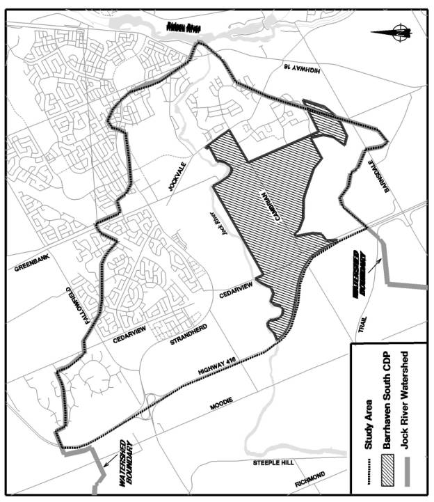
ENVIRONMENTAL CONSTRAINTS AND
OPPORTUNITIES
MAP AND KEY FINDINGS DOCUMENT
3
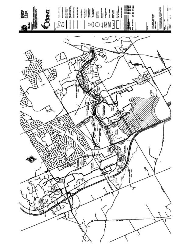
Tributaries:
· North
of the Jock River, the main tributaries are O’Keefe Drain, Foster Ditch and
Fraser Clarke Drain.
· South
of the Jock River, the main tributaries are the West Clarke Drain, East Clarke
Drain, Todd Drain and Corrigan tributary.
· O’Keefe, Fraser-Clarke, West Clarke, East Clarke and Todd tributaries are municipal drains.
· All
tributaries to the Jock River support fisheries and are considered fish
habitat.
· The
tributaries provide only a highly seasonal and marginal fish habitat for a
handful of warm water tolerant fish species.
· The
tributaries can run dry or low after high spring water levels.
· Tributaries
have been largely modified by channel straightening with little or no riparian
vegetation.
· As
per the Lower Rideau Watershed Strategy, if an integrated stormwater management
approach is undertaken consideration of partial or full enclosure of the drains
south of the Jock River can be considered if DFO requirements are fulfilled.
· Opportunity
exists to enhance low flows in the tributaries and Jock River through
stormwater management.
Terrestrial
Resources:
· A
total of 28 woodlands exist in the subwatershed.
· North
of the Jock River, Woodlot W44 (UNA #50), Woodlot W43 (UNA#60) and Woodlot W50
(UNA #183) are considered significant woodlands.
· South
of the Jock River, Woodlots W1 and W2 (UNA #57), Woodlot W4 (rural), Woodlot W7
(UNA #49) and W10 (UNA #58) are considered significant woodlands.
· Management
plans should be prepared to maintain environmental integrity of the woodlands
over the long-term.
· There
is very low representation of wetlands within Reach 1.
· A
total of 88 species of birds has been recorded as breeding in the area
including forest, edge and wetland species.
· Forest
interior habitat is contained within Woodlands W1 and W2 (UNA #57).
· A
total of 10 species of amphibians, 3 species of reptiles and 18 species of
mammals have been recorded.
· Significant
species reported or observed include one federal (butternut), one provincial
(greater redhorse fish species) and fourteen regionally rare species.
· Terrestrial
corridor function was identified along the Jock River.
· Terrestrial
corridor potential was identified along the O’Keefe Drain connecting Stony
Swamp and the Jock River.
Jock
River:
· Jock
River is highly productive fisheries resource that contains healthy populations
of naturally reproducing game fish such as muskellunge.
· A
number of important and/or critical fish habitat areas within the main stem of
the Jock River have been identified within Reach 1.
· There
is limited riparian vegetation along the river corridor.
· Groundwater
flow is generally towards the river that is identified as a discharge area.
· Recharge
area function associated with sand and gravel resource areas, south of Cambrian
Road, was identified.
· Low
summer flows in the Jock River.
· Jock
River water quality is highly impaired and does not meet provincial water
quality criteria.
· The
Jock River is classified as a Policy 2 watercourse for phosphorus, which
requires a net reduction in phosphorus loadings to the river.
· The
extent of the regulatory floodplain through Reach 1 is defined by the 100-year
flood as per mapping recently updated by the Rideau Valley Conservation
Authority in November of 2005
· Through
the fluvial geomorphoric investigation, the meander belt width was determined
for the Jock River corridor representing the maximum lateral extent of the
channel voer time. Meander belt is
considered a hazard constraint that needs to be considered in establishing development
setbacks from the river.
· Further erosion and migration analysis is recommended for Reaches 1 and 2 of the Jock River to confirm meander belt width.
MASTER SERVICING PROJECTS: FIGURES SAN-1, WM-1,
6.3, ST-1 AND GP-1 DOCUMENT
4
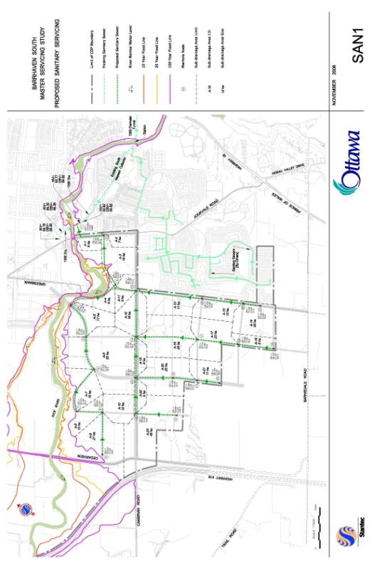
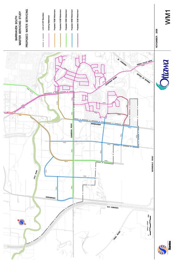
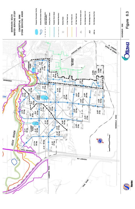
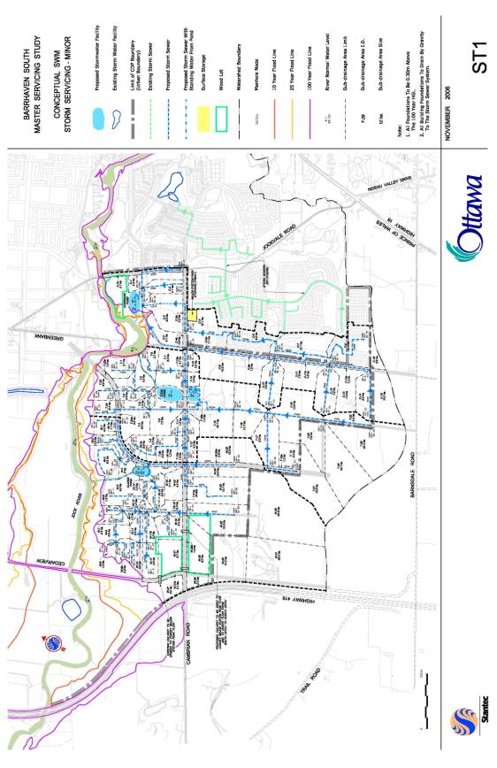
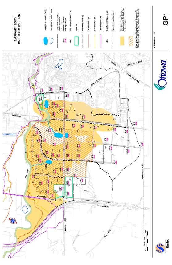
CONCEPTUAL STORMWATER MAGEMENT
OPTION 2,
NORTH OF THE JOCK RIVER – FIGURE
6.4.2 DOCUMENT
5
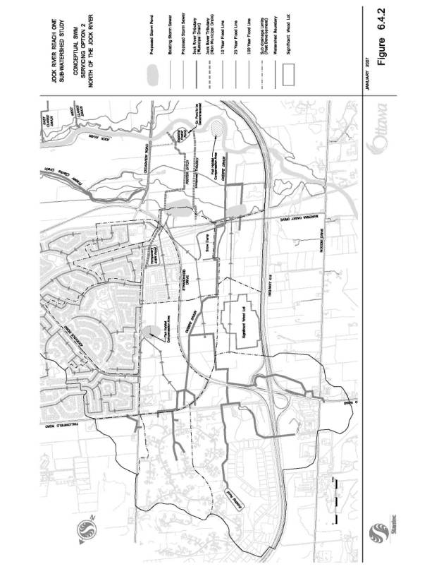
MASTER SERVICING STUDY: EVALUATION OF
STORMWATER MANAGEMENT ALTERNATIVES DOCUMENT
6
Capital
costs were estimated based on the following criteria:
· Ponds have been sized and costed
assuming quality control only
· Storm sewers have been sized using
the 5-year rational method.
Based
on the above criteria, the total estimated capital cost for each alternative
was determined to be:
· Option 1 - $54 million
· Option 2 - $41 million
· Option 3 - $39 million
· Option 4 - $43 million
· Option 5 - $42 million
Option
1 was most expensive due to large deep storm trunks sewers. Option 5 was the
next most expensive due to the number of ponds and associated land costs.
Option 3 was least expensive, using centrally located ponds. Option 4 was
similar to Option 3.
Maintenance
costs:
Maintenance
costs were assessed using the suggested practices in the Stormwater Management
Planning and Design manual, Ministry of the Environment (March 2003).
· Due to the site having a large, low-lying area and grade raise restrictions over this same area, all options considered would result in a similar amount of submerged pipe. Maintenance costs for the submerged systems were similar for all alternatives.
· Option 1 was more economical with respect to maintenance costs; Option 5 less economical.
Fish
and Aquatic Life
i)
Low Flow Augmentation to Tributaries via SWM:
· Use of storm ponds to augment flow in rehabilitated tributaries to support future fish habitat
· Options 1 and 2 provide no
opportunity (no drains remain open).
· Options 2 and 3 provide the greatest opportunities as they concentrate more surface water to two tributaries/drains.
ii)
Enhancement of Existing Aquatic Habitat:
· Options 1 and 2 provide no
opportunity.
· Option 3 provides the best opportunity to increase diversity of fish community in two tributaries providing improved slopes and augmented flow from storm ponds.
· Option 4: longer flat tributaries with 5 proposed ponds provides less water at the tributary head than Option 3.
· Option 5: maintains existing conditions with ditches and associated (degraded) habitat as it exists today
iii) Preservation and Enhancement of Sensitive
Habitat:
Options 3 and 4 augment flow to the muskie spawning
habitat identified adjacent to the Jock River, also providing the opportunity
to enhance these areas. Option 1 provides no augmented flow to these areas,
while Option 2 provides limited opportunity.
iv)
Maintain Existing Baseflow Contribution from Woodlot (UNA #57):
· Options 1 and 2 do little to maintain
base flow
· Option 5 most closely represents
existing conditions
· Option 4 with more ponds and greater
ditch lengths scores slightly higher than Option 3
Terrestrial
Vegetation and Communities:
i)
Preservation of Urban Natural areas
All
options provide the same opportunity
ii)
Preservation of Riparian Vegetation
Option
1 provides the least opportunity, while Option 5 provides the most. Options 2,
3, and 4 provide increasingly better opportunities, respectively.
iii)Preservation
of landscape features
Option
1 provides the least opportunity, while Option 5 provides the best. Options 2,
3, and 4 provide increasingly better opportunities respectively.
Social/Community:
i)
Maintain existing recreation activities:
Existing
recreation activities are limited to the river corridor. Based on this, Option
3 with the fewest ponds proposed adjacent to the river provides the least
impact. Options 1 and 5 have the greatest impact. Options 2 and 4 have similar
impacts.
ii)
Integrate with Green Open Space/Park System:
· With no ponds within the community
Option 1 and 2 provide limited opportunity
· Option 5 has too many ponds; roadway crossings and pedestrian crossing will be a constraint
· Option 3 and 4 provide the best
opportunities
iii)
Integrated/Links with pedestrian network:
· With no ponds integrated in the
community, Options 1 and 2 provide limited opportunity
· Option 5 has numerous many ponds; roadway and pedestrian crossings would be a constraint
· Options 3 and 4 provide the best
opportunities.