|
7.
ZONING
- PART OF 4798 BANK STREET
ZONAGE - PARTIE DU 4798,
RUE BANK
|
Committee recommendation
That Council approve an amendment to the former City of Gloucester Zoning
By-law to change the zoning of part of 4798 Bank Street as shown in Document 1
and as detailed in Documents 2 and 3.
Recommandation du Comité
Que le Conseil approuve une modification au Règlement de zonage de
l’ancienne Ville de Gloucester visant à modifier la désignation de zonage d’une
partie de la propriété située au 4798, rue Bank, comme l’illustre le document 1
et le précisent les documents 2 et 3.
Documentation
Deputy City Manager's report Planning, Transit and the Environment dated
24 January 2007 (ACS2007-PTE-APR-0065).
Report to/Rapport au :
Planning and Environment Committee
Comité de l'urbanisme et de l'environnement
and Council / et au Conseil
January 24, 2007 / le
24 janvier 2007
Submitted by/Soumis par : Nancy Schepers, Deputy City Manager/
Directrice municipale adjointe
Planning, Transit and the Environment/ Urbanisme,
Transport en commun
Contact Person/Personne ressource : Karen Currie,
Manager / Gestionnaire, Development Approvals / Approbation des demandes
d'aménagement
(613) 580-2424, 28310 Karen.Currie@ottawa.ca
|
SUBJECT: |
|
|
|
|
|
OBJET : |
ZONAGE - PARTIE
DU 4798, RUE BANK (DOSSIER NO D02-02-06-0144) |
REPORT RECOMMENDATION
That the Planning and Environment Committee recommend Council approve
an amendment to the former City of Gloucester Zoning By-law to change the
zoning of part of 4798 Bank Street as shown in Document 1 and as detailed in
Documents 2 and 3.
RECOMMANDATION DU RAPPORT
Que le Comité de l’urbanisme et de l’environnement
recommande au Conseil d’approuver une modification au Règlement de zonage de
l’ancienne Ville de Gloucester visant à modifier la désignation de zonage d’une
partie de la propriété située au 4798, rue Bank, comme l’illustre le document 1
et le précisent les documents 2 et 3.
BACKGROUND
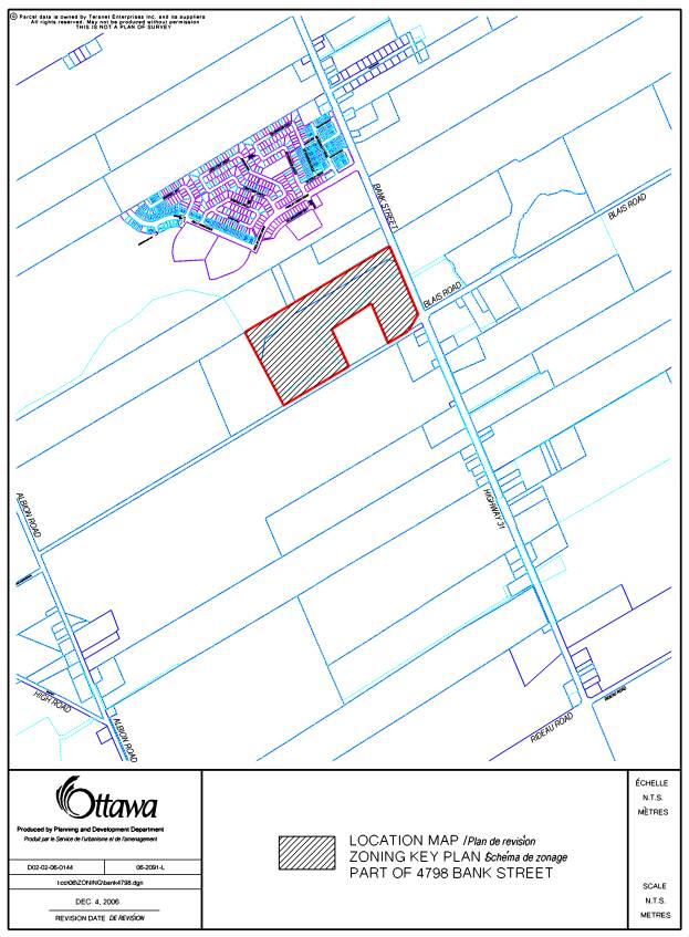
The site is located west of Bank Street, south of Findlay Creek, east of the Leitrim Wetlands and north of the unopened Blais Road extension. The property does not include a portion of lands that are owned by Transport Canada.
The applicant wishes to proceed with residential development of all the lands subject to this application. The proposed Zoning By-law amendment is required to allow further development of the Leitrim Community as set out in the subdivision draft approval for Stage 2 of Findlay Creek.
Existing Zoning
The lands that are the subject of this Zoning By-law amendment are currently zoned Future Growth, Fg and Open Space, Os.
The intention of the zoning is to continue the characteristics of the existing Findlay Creek Community into the final portion of the lands to be developed by Tartan. This area is know as Findlay Creek – Phase 2B and the requested zoning is as follows:
- Open Space, Os zone to recognize a proposed public park and corridor of lands abutting the Leitrim Wetland.
- Special Mixed Residential Dwelling 3 Zone (Exception
XX), Rc3(EXX) to permit
the construction of singles, semi-detached and street row dwelling units
with site specific permitted projections into exterior side yards
dependent on road widths and a minimum residential density of 29 units per
hectare.
- Medium
Density Apartment 2 Zone, Ra2 to permit the construction of low apartments
on specific blocks.
The Leitrim Community Design Plan is being met
with the provision of a low rise, medium density apartment block, which is to
be zoned Ra2, in the south east corner of this area.
DISCUSSION
The Official Plan places the site in the General Urban Area with a Developing Community Overlay. The overlay designation requires that a Community Design Plan be completed prior to any development being approved and that a minimum residential density of singles, semi‑detached and townhouses of 29 units per net hectare be provided. The Leitrim Community Design Plan was approved by City Council on July 13, 2005.
The site is impacted by the Airport Vicinity Development Zone. All development within the Airport Vicinity Development Zone is to be protected from effects of aircraft noise. This is provided for in the subdivision approval.
The intent of the “General Urban” designation is to provide a full range of housing types in combination with conveniently located employment, services, cultural, leisure, entertainment and institutional uses. This designation permits all types of densities of housing as well as park and institutional uses.
The applicant is requesting that the zoning of
the subject lands be changed to implement the subdivision draft approval for
Leitrim – Stage 2 which was issued on July 7, 2006.
One of the zoning changes being requested is a
result of the relocation of the stormwater facility servicing the Leitrim area
to the east side of Bank Street. A
portion of the area currently zoned Os was part of the original stormwater
management system which included the relocation of Findlay Creek. With the redesign of the stormwater
facilities and the pond’s present location along Blais Road, east of Bank
Street, these lands have been approved for residential development as part of
the Leitrim Community Design Plan and the draft approval for Stage 2. Findlay Creek has been left in its original
location and is protected by a buffer that is zoned Os. The applicant is requesting that the land
that has been approved for development be rezoned from Os to Rc3(EXX).
The Rc3(EXX) zone being requested is to permit
site specific projection provisions for single dwellings, semi-detached
dwellings and street row dwellings abutting various street widths. This will enable the dwelling units to have
projections closer to the street lot line depending on the street width. This will also permit interesting architectural
treatment along the exterior side yards.
The minimum residential density is 29 units per net hectare.
There is to be a public park within this area
of development. A portion of the park
is presently zoned Os and a zoning change is requested for the remainder of the
park from Fg to Os.
A low rise apartment block is to be located in
the south east corner of the development and the applicant has requested that
the zone be changed from Fg to Ra2 to permit construction of Java units at this
location.
A small addition to the existing buffer
corridor around the Leitrim Wetland is being rezoned from Fg to Os.
The proposed Zoning By-law amendment meets the
guidelines of development established within the Leitrim Community Design Plan
and is compatible with the existing residential area. It provides for a mix of residential uses in a form that
satisfies the density objectives of the Official Plan. The provision of the Rc2 zone guarantees
this component of Leitrim will satisfy its share of the 10 percent apartment development
requirement. The Open Space zones will
provide for the necessary park as well as providing buffer lands along the
wetland and Findlay Creek.
Staff supports this proposed Zoning By-law
amendment as it meets the intent of all applicable policies, provides a
mechanism to facilitate development and provides for a range of housing types
and models in the Leitrim Community.
ENVIRONMENTAL IMPLICATIONS
Throughout the approval of the Leitrim Community Design Plan and the draft subdivision approval, there have been concerns and objections expressed about the environmental sensitivity of lands due to the Leitrim Wetlands. The limits of the Leitrim Wetlands were defined in an Ontario Municipal Board decision in 1991.
CONSULTATION
Notice of this application was carried out in accordance with the City's Public Notification and Consultation Policy. The Ward Councillor is aware of this application and the staff recommendation. The City did not receive any negative comments or opposition to this application.
FINANCIAL IMPLICATIONS
APPLICATION PROCESS
TIMELINE STATUS
This application was processed by the "On Time
Decision Date" established for the processing of Zoning By-law amendment
applications.
SUPPORTING DOCUMENTATION
Document 1 Location Map
Document 2 Details
of Recommended Zoning
Document 3 Proposed
Zoning Map
DISPOSITION
Corporate Services Department, City Clerk’s
Branch, Secretariat Services to notify the owner, 1374537 Ontario Ltd./Findlay
Creek Properties, 237 Somerset Street, West, Ottawa, Ontario, K2P 0J3;
applicant, Pierre Dufrense, Tartan Land Corporation, 237 Somerset Street, West,
Ottawa, Ontario, K2P 0J3; OttawaScene.com,
174 Colonnade Road, Unit #33, Ottawa, ON
K2E 7J5,
Ghislain Lamarche, Program Manager, Assessment, Financial Services Branch
(Mail Code: 26-76) of City
Council’s decision.
Planning, Transit and the Environment
Department to prepare the implementing by-law, forward to Legal Services Branch
and undertake the statutory notification.
Corporate Services Department, Legal Services
Branch to forward the implementing by-law to City Council.
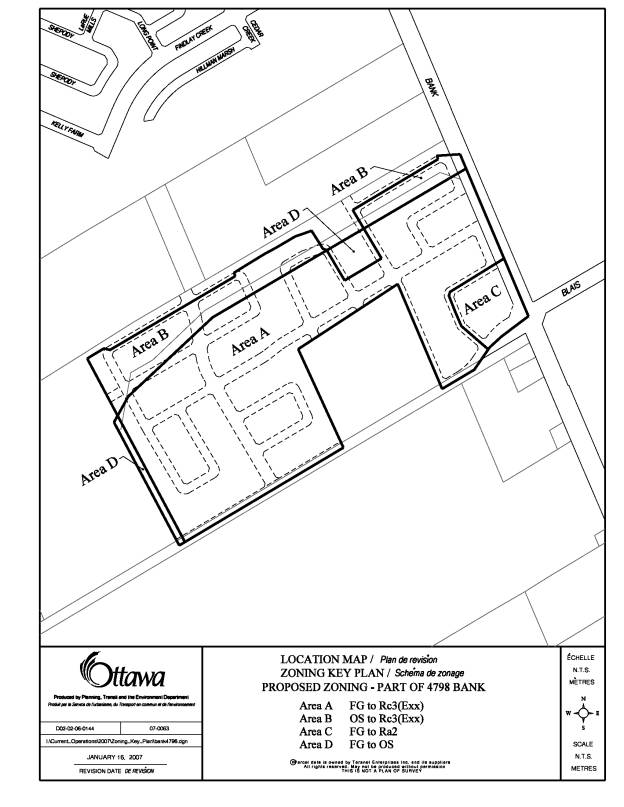
LOCATION MAP DOCUMENT
1
DETAILS OF RECOMMENDED ZONING DOCUMENT
2
The following changes are proposed to Zoning By-law 333 of 1999 of the former City of Gloucester:
1. The site located at part of 4798 Bank Street on Document 1 to be rezoned as follows and that Map 23D of Zoning By-law 333 of 1999 be amended to reflect the following zones as shown in Document 3:
Area A Fg, Future growth be rezoned to Rc3(Exx), Special Mixed Residential Dwelling (Exception xx);
Area B Os, Open Space be rezoned to Rc3(Exx), Special Mixed Residential Dwelling (Exception xx);
Area C Fg, Future growth be rezoned to Ra2, Medium Density Apartment;
Area D Fg, Future growth be rezoned to Os, Open Space
2. A new zone be added to Subsection 6.18 as follows:
Despite any provision in this by-law to the contrary, the lands zoned Rc3(Exx) are
subject to the following provisions:
1) The required minimum residential density is 29 units per hectare.
2) Despite the permitted projections in Table 1 of clause 3.9.1 the following table sets out how close certain structures or building features can come to street lot lines:
|
Structure or Building Feature |
Roadway Width Abutting Street Lot Line |
Minimum Street Lot Line Setback |
|
covered but unenclosed porch not being part of the main building foundation, that is erected on sonotubes or some other self-supporting mechanism, step or veranda or gazebo. |
18 m or greater in width |
1.5 metres |
|
14 m or greater but less than 18 metres in width |
3.0 metres |
|
|
uncovered step, ramp, deck or porch, not being part of the main building foundation, that is erected on sonotubes or some other self-supporting mechanism, except for a ramp designed to be used by persons with disabilities, where no minimum setback is required. |
18 m or greater in width |
1.5 metres |
|
14 m or greater but less than 18 metres in width |
3.0 metres |
|
|
balcony, bay window, belt courses, chimney breasts, cornices, eaves, gutters, pilasters or other similar architectural features and sills. |
14 m or greater but less than 18 metres in width |
3.0 metres |
PROPOSED ZONING MAP DOCUMENT
3