|
14. NICHOLAS
MANN GATEWAY L’AMÉNAGEMENT DE LA STRUCTURE D’ACCUEIL NICHOLAS MANN |
Committee recommendationS
That Council:
1.
Approve
the City’s participation in the Nicholas Mann Gateway as described in Document
1, through the Planning, Environment and infrastructure
policy branch.
2.
Approve
the funding of $20,000 to support the Community’s participation in the Nicholas
Mann Gateway community planning initiative.
3.
Support
the allocation of seed funding of $60,000 in the 2007 budget for the City of
Ottawa’s 10% component of a future Federation of Canadian Municipalities (FCM)
request for Green Municipal Funds Grants.
RecommandationS du Comité
Que le Conseil :
1. Approuve
la participation de la
Ville à l’aménagement de la structure d’ accueil de Nicholas Mann tel que
décrit dans le document 1, par l’entremise du département des politiques
d'urbanisme, d'environnement et d'infrastructure
2.
Approuve le financement de la somme de 20, 000$ afin
de supporter l’initiative et la participation communautaire à l’aménagement de
la structure d’accueil Nicholas Mann.
3.
Supporte l’allocation d’un financement de base de
60, 000$ dans son budget de 2007 afin d’assurer la composante de 10% que la contribution de la Ville d’Ottawa offrira
dans une éventuelle demande de la Fédération canadienne
des municipalités pour une bourse provenant des fonds municipaux verts.
Documentation
1.
Councillor Bédard’s report, Ward 12, Rideau-Vanier dated 22 January
2007
(ACS2007-CCS-PEC-0001).
Report to/Rapport au:
Planning and Environment Committee
Comité de l'urbanisme et de
l'environnement
and Council/ et au Conseil
22
January 2007 / le 22 janvier 2007
Submitted by/Soumis
par : Georges Bédard, Councillor Ward 12 / Conseiller
Quartier 12
Contact
Person/Personne ressource : Georges Bédard, Councillor Ward 12 /
Conseiller Quartier 12
(613) 580-2482, georges.bedard@ottawa.ca
|
SUBJECT: |
|
|
|
|
|
OBJET : |
REPORT RECOMMENDATIONS
That
Council approve the City’s participation in the Nicholas Mann Gateway as
described in Document 1, through the Planning, Environment and infrastructure
policy branch.
That Council approve the funding of $20,000 to
support the Community’s participation in the Nicholas Mann Gateway community
planning initiative.
That Council support the allocation of seed funding
of $60,000 in the 2007 budget for the City of Ottawa’s 10% component of a
future Federation of Canadian Municipalities (FCM) request for Green Municipal
Funds Grants.
That
the Planning and Environment Committee recommend Council:
1. Approve
the City’s participation in the Nicholas Mann Gateway as described in Document
1, through the Planning, Environment and infrastructure policy branch.
2. Approve
the funding of $20,000 to support the Community’s participation in the Nicholas
Mann Gateway community planning initiative.
3. Support
the allocation of seed funding of $60,000 in the 2007 budget for the City of
Ottawa’s 10% component of a future Federation of Canadian Municipalities (FCM)
request for Green Municipal Funds Grants.
RECOMMANDATIONS DU RAPPORT
Que
le Comité de l’urbanisme et de l’environnement recommande au Conseil :
1. D’approuver la participation
de la Ville à l’aménagement de la structure d’ accueil
de Nicholas Mann tel que décrit dans le document 1, par l’entremise du
département des politiques d'urbanisme, d'environnement et d'infrastructure.
2.
D’approuver le financement de la somme de 20, 000$
afin de supporter l’initiative et la participation communautaire à
l’aménagement de la structure d’accueil Nicholas Mann.
3.
De supporter l’allocation d’un financement de base
de 60, 000$ dans son budget de 2007 afin d’assurer la composante de 10% que la contribution de la Ville d’Ottawa offrira
dans une éventuelle demande de la Fédération canadienne
des municipalités pour une bourse provenant des fonds municipaux verts.
Que le
Conseil approuve la participation de la
Ville à
l’aménagement
de la
structure d’ accueil de
Nicholas Mann tel que décrit dans le document 1, par l’entremise du département
des politiques d'urbanisme, d'environnement et d'infrastructure
Que le
Conseil approuve le financement de la somme de 20, 000$ afin de supporter l’initiative et
la participation
communautaire à
l’aménagement
de la
structure d’accueil Nicholas
Mann.
Que le
Conseil supporte l’allocation d’un financement de base de 60,
000$ dans son
budget
de 2007 afin
d’assurer la composante de 10% que la
contribution
de la Ville
d’Ottawa offrira
dans
une
éventuelle demande de la Fédération Canadienne des Municipalités pour une bourse provenant des fonds
municipaux verts.
BACKGROUND
The owners of several lots of land located between Mann Avenue and the Queensway have begun a process along with several local stakeholders, (as described in Document 1) to determine how the land could be rehabilitated and better used. This land is among the first impressions that a visitor has of Ottawa when arriving by road of the Nicholas ramp. Much of the land is vacant and unlandscaped or used as a spaghetti network of roads.
The
area in question is known to have had industrial uses in the past and some of
it was used as a snow dump. As such, it
is considered a priority brownfield site identified in the city's proposed
Brownfield Redevelopment Strategy.
This site is unique in that
- It is highly
visible
- The City of Ottawa
owns or leases most of the land
- The remainder of
the land is primarily publicly owned
- It currently
generates virtually no revenue
- It is partially
surrounded by residential uses
- Roads currently
lock up much of the land
These
lands are currently designated as "Parks, Open Space, and Public
Uses" in the Sandy Hill Secondary Policy Plan.
The
current major owners of the lands in this area include the City of Ottawa, the
Ministry of Transportation (MTO), the National Capital Commission (NCC), the
University of Ottawa, and the Mobin Foundation; some adjoining land belonging
to Ottawa Community Housing Corporation (OCHC) may also form part of this
exercise. The land located under the
arena is currently under long-term lease to the City of Ottawa from the
NCC. All of the owners are aware of the
process and representatives of the owners and stakeholders have been meeting
regularly for over a year, under the chairmanship of the ward councillor
Georges Bédard.
The
process has come to a point where professional resources are required. The Canadian Mortgage Housing Corporation (CMHC) has provided $
20,000 for the visioning charettes and a portion of the funds needed by the
community to hire a planner to help them through the process. Further
activities under the process seem to fit the eligibility criteria for the FCM's
"Green Municipal Fund grants for feasibility studies, field tests and
sustainable community plans", to which municipal governments may apply.
DISCUSSION
In
December 2004, a group of interested parties, including representatives from
the University of Ottawa and Action Sandy Hill, and two individuals, Roger
Tucker and Barry Lithwick, assisted by the councillor for Ward 12 Georges
Bédard, decided to explore what could be done to make better use of the lots
comprising approximately 29.1 acres of mostly publicly-owned land, and to do
this on the basis of a novel consensus-driven cooperative community planning
process. Over the next few months, the
landowners and other major stakeholders were approached and agreed to
participate in the process.
The lands, whose borders are shown in Document 2,
are an interlocking maze of irregularly shaped lots and rights-of-way. None of the landowners has developed any
significant plans for the future of the lands, but all agree that they are not
being used to their full potential. The
current uses include:
- the 30
plus year old Sandy Hill Arena, which is built on land that the City
leases from the NCC and includes a large surface parking lot,
- a
university-owned surface parking lot,
- a
baseball diamond,
- the Iranian Cultural Centre,
- a
community garden,
- a few walking paths, and
Most of the remaining land is unused. The lands are
criss-crossed with curved access roads linking King Edward avenue, the
Queensway, Mann avenue, and Robinson avenue, with an overpass leading to Lees
Avenue on the other side of the Queensway.
The lands are particularly well located, well
connected by all modes of transportation, and within walking distance of
downtown. The lands bridge the gap
between Robinson Village and the rest of the Sandy Hill community, and are also
contiguous with the University of Ottawa.
The city arena is approaching the age where a major refit will be
required. The overpass over the
Queensway is also approaching a regular review by the MTO, which is a good
opportunity to determine whether it and its approach could be redesigned or are
needed at all.
The stakeholders in the process have agreed to a
process that requires stakeholder consensus.
It is an innovative community planning method whereby community groups
are equal stakeholders with the landowners throughout the planning and
development process and beyond. However to ensure that they have expert advise,
funding must be provided for the community to hire professional assistance.
The stakeholders have agreed to exchange
confidential information that can later be used to assess brownfield
remediation requirements. They have all
contributed some staff time and have upper management support. On July 5 2005, the Deputy City Manager
indicated that a staff member would be assigned to help facilitate the
study. None of the stakeholders,
including the City of Ottawa, is currently contributing financially, however,
the University of Ottawa has indicated that it is willing to match a grant from
the City of Ottawa up to $20,000. It is
the understanding of the stakeholders that initial community planning phases of
the project including the funding for future professional assistance for the
community are eligible for FCM's Green Municipal Fund grants for feasibility
studies, field tests and sustainable community plans.
Since these grants are only available to municipal
governments with a minimum contribution of 10% for the overall project, the
next step is for the City to apply for this grant. A request of $60,000 for
seed funding as part of the 2007 budget would allow the City to participate in
the process which will assist in securing funding from all landowner partners
in the project. The University of Ottawa has agreed to match the City's seed
funding of $60,000 to participate in the grant request process. The FCM application
will require that staff time be made available for this process.
This initiative fits well with the new Ottawa Brownfields Redevelopment Strategy, and the City's preparation of that strategy is among the factor that make this project possible. It is also a useful extension of the work carried out recently by the City and the University of Ottawa concerning the future of the area around King Edward avenue.
The project is consistent with the city's objective to pursue brownfields redevelopment, and the objective to promote collaborative community planning as detailed in the Official Plan.
Departmental Comments
Planning, Transit and the Environment have been aware of the Nicholas-Mann Gateway project since its inception in December 2004. During this time, the Planning, Environment and Infrastructure Policy Branch has provided a person to be a liaison between the City and the partner agencies and groups, and to attend all meetings.
Planning, Transit and the Environment supports the Nicholas-Mann Gateway project as an opportunity to redevelop brownfield lands which currently make little or no contribution to the surrounding area or to the city as a whole. The lands are extremely well-situated, being on the Transitway between the University of Ottawa’s main Sandy Hill campus and the former campus of Algonquin College on Lees Avenue, which has been recently purchased by the University. If sufficiently redeveloped, an additional Transitway station at this location could be considered.
In 2004, the University of Ottawa retained Urban Strategies Inc. to update the Master Plan for the University’s Sandy Hill campus. One component of that Master Plan update is the King Edward Avenue Precinct Strategy, completed in January 2005. Urban Strategies was also the author of the Downtown Ottawa Urban Design Strategy 2020, approved by City Council on March 10, 2004. The Downtown Design Strategy contains some forty specific projects to improve Ottawa’s downtown, of which the King Edward Avenue Precinct Strategy is one. Completion of the King Edward Precinct Strategy creates a plan for the University’s lands between King Edward and Henderson, all the way south to Mann Avenue, which is the northeast boundary of the Nicholas-Mann Gateway project.
With its purchase of the former Algonquin campus on Lees Avenue, the University will create a plan for that area at some future date, as yet undetermined. The Nicholas-Mann Gateway project will enable planning to start now for a major piece of under-developed property that could eventually help to link the Sandy Hill campus with the Lees Avenue campus along the Transitway.
Given the scale of the Nicholas-Mann Gateway area, its strategic location, and the multiple ownership of the lands, this Department recommends that the Nicholas-Mann Gateway project be a Community Design Plan as described in the Official Plan, and be structured accordingly. This would be complementary to the Nicholas-Mann Gateway as a priority Brownfield project (“Ottawa Brownfields Redevelopment Strategy and Brownfields Redevelopment Community Improvement Plan,” ACS2007-PTE-POL-0003, Planning and Environment Committee Agenda 3, item 15, 23 January 2007).
Funding for the Nicholas-Mann Gateway project as described in this report could be sourced from Internal Order 903261, Redevelopment Studies-Streetscaping, if this account has sufficient funds following Council’s consideration of the 2007 Draft Budget.
CONSULTATION
Action Sandy Hill, the community association for this area, is aware of the motion and is a participant in the process. The Strathcona Heights Tenants Association and the Robinson village community are also aware of the process and are full participants.
There has been a well-attended public meeting in January 2006 where local residents all expressed agreement with the current process.
The NCC, the University of Ottawa, OCHC, and the Mobin Foundation and CMHC are actively participating in the process.
FINANCIAL IMPLICATIONS
Funds in the amount of $20,000 are available from the City-Wide Reserves. The $60,000 recommendation for one time funding will be included for consideration in the 2007 Draft Budget.
Some positive financial benefits come from the possibility of deriving future revenues and avoiding expenditures as a result of improvements to city-owned lands and city facilities on land owned by other stakeholders. The value of these revenues and cost avoidance will only be known later in the process.
SUPPORTING DOCUMENTATION
Document 1 – Description of the process
Document 2 – Map of the area
DISPOSITION
DESCRIPTION
OF THE NICHOLAS-MANN
GATEWAY PROCESS
Where: The lands are adjacent to the Nicholas exit off Highway 417 in a rough triangle bounded by Lees Avenue, Mann Avenue and Chapel Street, excluding housing near the northern apex but including the semi circle between Lees Avenue and Highway 417 (the “Lands”). The lands are owned by the NCC, the University of Ottawa, the Mobin Foundation and the City of Ottawa (the “Owners”).
Why: The Lands have the potential of creating a significant entrance to the City as well as a gateway to the local community. Currently, these “brownfield” lands (previous industrial sites) are generally poorly organized, with the dominant use being roadways and surface parking. The Lands are zoned for leisure, open space and institutional uses. There is a consensus that the Lands are not being used to their full potential.
The community has clearly communicated that it does not want a reactive, confrontational relationship in any process considering development. Rather, the community seeks a pro-active and constructive role from the start to the finish. Given the different interests involved and the challenge to improve these Lands, the stakeholders are proposing an innovative process to initiate and control development. A collective approach with full community support will provide the governance and resources needed to improve the Lands. Together the participants significantly improve their abilities to access funding.
Who: This is a collaborative community initiated process chaired by Councillor Georges Bédard
involving Action Sandy Hill, Strathcona Heights Community Association, the Robinson Village, the University of Ottawa, the NCC, the Mobin Foundation, CMHC and the City of Ottawa as well as Barry Lithwick and Roger Tucker as process originators and facilitators (collectively the “Participants”). The Provincial Ministry of Transportation (“MTO”) will be approached when the process is more advanced.
How: The Owners and the community will jointly consider alternatives and define development parameters that reflect community interests and provide benefits to all parties. The Participants will have the opportunity to present proposals to their organisations for endorsement. The objective of this process is to constructively explore all possible uses. If appropriate, the participants will then jointly issue a request for proposals (“RFP”) to builders. This RFP will be attractive to builders because of the certainty of planning approvals and ongoing community support. Various forms of land ownership and controls may be considered.
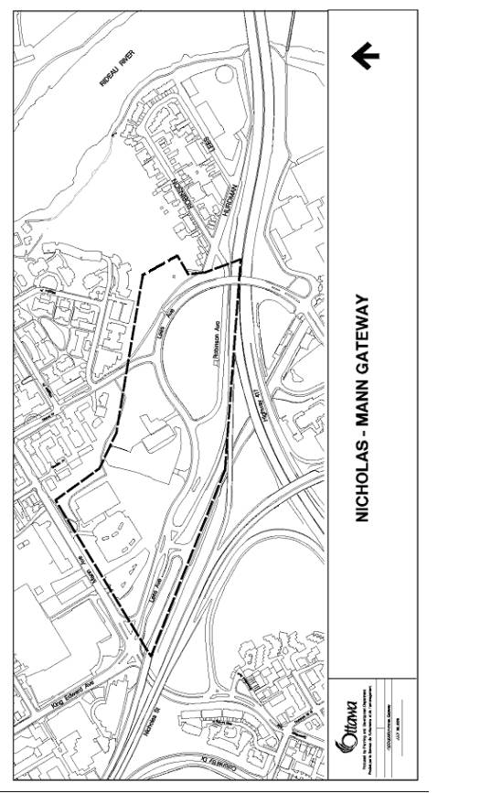 MAP OF THE AREA
Document
2