|
4. ZONING - 100 LANDRY STREET ZONAGE - 100,
RUE LANDRY |
Committee recommendations
That Council approve an amendment to the
former City of Vanier Zoning By-Law 2380 for 100 Landry Street as follows:
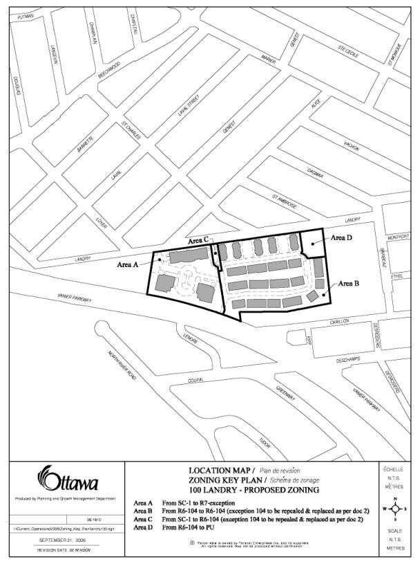
1. To change the Zoning for the northeast portion of the R6-104
Residential Complex Zone to a Public Use Zone (PU) as detailed in Document 2
and shown as Area D in Document 3;
2. To repeal exception 104 in the R6-104 Residential Complex Zone and
establish a new exception with provisions as detailed in Document 2 and shown
as Area B on Document 3;
3. To change the SC-1 Special Commercial Zone
pertaining to Area C on Document 3 to R6-104 Residential Complex Zone with
exceptions as detailed in Document 2; and,
4. To change the SC-1 Special Commercial Zone
pertaining to Area A on Document 3 to R7 – exception, Residential Complex Zone
with exceptions as detailed in Document 2.
Recommandations du Comité
Que le Conseil approuve les modifications
suivantes au règlement de zonage 2380 de l’ancienne Ville de Vanier,
relativement au 100, rue Landry :
1. Modifier la désignation de la partie nord-est de la zone de
complexe résidentiel (R6-104) et la remplacer par une zone d’utilisation
publique (PU), décrite au document 2 et désignée comme le secteur D dans
le document 3 ;
2. Révoquer l’exception 104 à la zone de complexe résidentiel
(R6-104) et établir une nouvelle exception comportant les dispositions énoncées
dans le document 2 relativement à la partie désignée comme le secteur B dans le
document 3 ;
3. Modifier la zone commerciale spéciale (SC-1) visant la partie
désignée comme le secteur C dans le document 3 et la remplacer par une zone de
complexe résidentiel avec exceptions (R6-104), comme le précise le
document 2 ; et,
4. Modifier la zone commerciale spéciale (SC-1) visant la partie
désignée comme le secteur A dans le document 3 et la remplacer par une zone de
complexe résidentiel avec exceptions (R7 - exception), comme le précise le
document 2.
Documentation
1. A/Deputy City Manager's report (Planning
and Growth Management) dated
13 October 2006 (ACS2006-PGM-APR-0045).
2. Extract of Draft Minute, 24 October
2006.
Report to/Rapport au :
Planning and Environment Committee
Comité de l'urbanisme et de l'environnement
and Council / et au Conseil
13 October 2006 / le 13 octobre 2006
Submitted by/Soumis par : John L. Moser, Acting Deputy City Manager/
Directeur municipal adjoint par intérim,
Planning and Growth Management / Urbanisme et Gestion
de la croissance
Contact
Person/Personne Ressource : Grant Lindsay, Manager / Gestionnaire,
Development Approvals / Approbation des demandes d'aménagement
(613)
580-2424, 13242 Grant.Lindsay@ottawa.ca
|
SUBJECT: |
|
|
|
|
|
OBJET : |
REPORT RECOMMENDATIONS
That the Planning and Environment Committee recommend Council approve
an amendment to the former City of Vanier Zoning By-Law 2380 for 100 Landry
Street as follows:
1.
To change the
Zoning for the northeast portion of the R6-104 Residential Complex Zone to a
Public Use Zone (PU) as detailed in Document 2 and shown as Area D in Document
3;
2.
To repeal exception
104 in the R6-104 Residential Complex Zone and establish a new exception with
provisions as detailed in Document 2 and shown as Area B on Document 3;
3. To change the SC-1 Special
Commercial Zone pertaining to Area C on Document 3 to R6-104 Residential
Complex Zone with exceptions as detailed in Document 2;
4. To change the SC-1 Special
Commercial Zone pertaining to Area A on Document 3 to R7 – exception,
Residential Complex Zone with exceptions as detailed in Document 2; and
And that the Planning and Environment Committee direct that this report
be heard at the Council Meeting of October 25, 2006.
RECOMMANDATIONS DU
RAPPORT
Que le Comité de recommande au Conseil d’approuver les modifications suivantes au
règlement de zonage 2380 de l’ancienne Ville de Vanier, relativement au 100,
rue Landry:
1.
Modifier
la désignation de la partie nord-est de la zone de complexe résidentiel
(R6-104) et la remplacer par une zone d’utilisation publique (PU), décrite
au document 2 et désignée comme le secteur D dans le document 3;
2.
Révoquer
l’exception 104 à la zone de complexe résidentiel (R6-104) et établir une
nouvelle exception comportant les dispositions énoncées dans le document 2
relativement à la partie désignée comme le secteur B dans le document 3 ;
3.
Modifier
la zone commerciale spéciale (SC-1) visant la partie désignée comme le secteur
C dans le document 3 et la remplacer par une zone de complexe résidentiel avec
exceptions (R6-104), comme le précise le document 2 ;
4.
Modifier
la zone commerciale spéciale (SC-1) visant la partie désignée comme le secteur
A dans le document 3 et la remplacer par une zone de complexe résidentiel avec
exceptions (R7 - exception), comme le précise le document 2;
Que le Comité de l’urbanisme et de l’aménagement
demande que ce rapport soit transmis de façon que le Conseil municipal puisse
en prendre connaissance à sa réunion du 25 octobre 2006.
EXECUTIVE SUMMARY
Assumptions and Analysis:
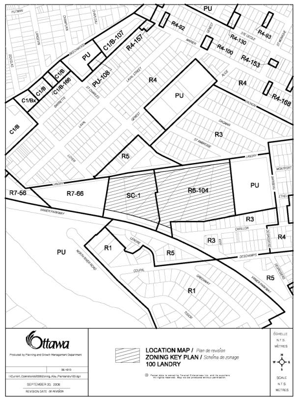
The subject property, 100 Landry Street, is located on the south side of the street between Charlevois Street to the west, Baribeau Street to the east, and bound by the Vanier Parkway to the south. The 3.91-hectare property, formerly occupied by a steel and fabrication industry (Dominion Bridge), is presently a vacant brownfield and is zoned SC-1, a Special Commercial Zone and R6-104, a Residential Complex Zone with exceptions. The applicant is requesting that the site be rezoned to accommodate a redevelopment proposal that includes a mix of high and medium density residential uses. The site is proposed to contain three high-rise apartment buildings, nine-storeys, 24 storeys and 25 storeys, all with underground parking in the western portion of the site. The nine-storey building is proposed to be either a 144-unit apartment building or a seniors residence accommodating up to 203 persons fronting onto Landry Street and the high-rise apartments, 24 and 25 storeys, are proposed further south of Landry Street and will consist of 213 and 222 units respectively. The central portion of the site will contain 76 townhouses, oriented on a private internal street and 60 units will be provided in five three-storey walk up apartments along the remaining Landry Street frontage. The northeast corner of the site, approximately 40 by 50 metres, is to be conveyed to the City for parkland.
The Planning and Growth Management Department has reviewed the proposal and is satisfied that the application to change the zoning can be supported as it satisfies Official Plan policies pertaining to development in the General Urban Area, design for compatibility, affordable housing, transportation, and development of a contaminated sites. The Department is recommending that the SC-1 Zone be repealed and that this portion of the site be designated an R7 Residential Complex Zone with exceptions that provide alternative yards for the proposed apartment buildings. Exception 104 of the R6 –104 Zone on the remainder of the site shown in Document 3 is proposed to be repealed and replaced with new provisions as detailed in Document 2. The northeast corner of the site will be rezoned to a Public Use Zone and conveyed to the City through the accompanying Site Plan Control application for parkland purposes. A small portion of this area, identified as Area C on Document 3, will be changed from SC-1 to R6-104. The alternative standards established in exception 104 have been developed to correspond with the site plan application being considered with this proposed Zoning By-Law amendment.
Financial Implications:
N/A
Public Consultation/Input:
Extensive comments were received from the public regarding this application as well as comments received from the three Public Meetings that were held by the Ward Councillor and written correspondence from concerned Community Associations. The comments were applicable to both the Site Plan Control and Zoning By-law Amendment Applications, since the Department and the public reviewed both concurrently. The community identified the following as the primary issues of concern: (1) The increase in traffic; (2) risks associated with site remediation; (3) objections to the height of building and proposed density; and (4) the lack of urban design and architectural considerations in the proposed plan.
RÉSUMÉ
Summary to follow / sommaire à
suivre
This report is
available in English only. The City of
Ottawa may translate this document or parts thereof on request. Requests for translation should be forwarded
to Saide Sayah at 613-580-2424, 27589 or saide.sayah@ottawa.ca.
Ce rapport n’est disponible qu’en anglais. La Ville pourra, sur demande, traduire ce
document au complet ou en partie. Les
demandes de traduction doivent être présentées à Saide Sayah au 613-580-2424,
27589 ou à saide.sayah@ottawa.ca.
BACKGROUND
The subject property, 100 Landry Street, is located on the south side of the street between Charlevois Street to the west, Baribeau Street to the east, and bound by the Vanier Parkway to the south. The 3.91-hectare property, formerly occupied by a steel and fabrication industry (Dominion Bridge), is presently a vacant brownfield. Abutting the property to the southeast are single and townhouse dwellings that front onto Carillon Street. Adjacent to the east is a one-storey former school building, which now operates as a cultural and community centre and play area. To the west is a 17-storey apartment building located at 40 Landry Street. North, across Landry Street, and south across the Vanier Parkway are residential areas containing a mix of low profile dwellings.
The applicant is proposing to redevelop the site into a mix of high and medium density residential uses. The western and high-density portion of the site is proposed to contain three high-rise apartment buildings, nine-storeys, 24 stories and 25 stories, all with underground parking. The nine-storey building is proposed to be either a 144-unit apartment building or a seniors residence accommodating up to 203 persons fronting onto Landry Street. The two high-rise apartments, 24 and 25 storeys, are proposed further south of Landry Street approximately 11.0 metres from the Vanier Parkway and will consist of 213 and 222 units respectively. The central portion of the site will contain 76 townhouses, oriented on a private internal street and 60 nits will be provided in five three-storey walk up apartments along the remaining Landry Street frontage. The northeast corner of the site, approximately 40 by 50 metres, is to be conveyed to the City for parkland.
The applicant is requesting an amendment to the property’s current Zoning By-law designations, R6-104 and SC-1 (see Document 1) to facilitate this proposal. The Department is recommending three different zoning designations for the site (Documents 2 and 3); an R6-104, Residential Complex Zone with new exceptions, to accommodate the townhouse and three-storey apartments proposed for the site; an R7- exception, Residential Complex Zone for the western portion of the site that contains the high-rise apartment buildings; and a PU, Public Use Zone for the proposed park in the northeast corner of the site.
DISCUSSION
The proposed Zoning By-law amendment is considered to be consistent with the policies of the City’s Official Plan. The land uses and residential densities in the recommended zoning advance the strategic directions of the Official Plan as they pertain to Managing Growth within the Urban Area (Section 2.2.3), development criteria to be considered for proposals in the General Urban Area Designation (Section 3.6.1), the Compatibility and Community Design Section (2.5.1) as well as Affordable Housing, Transportation and Contaminated Site policies.
Official Plan
Policies
The Official Plan advocates accommodating growth by directing it to urban areas to accommodate the City’s 20-year requirement for housing while at the same time creating liveable communities by providing a balance of facilities and a variety of housing types. The proposed zoning will foster a diversified residential development along the north side of the Vanier Parkway close to the Beechwood Village area, adjacent to Baribeau Park, and within 1500 metres of the Central Area. The proposal consisting of townhouses, three-storey walk up apartments and three high-rise apartment buildings will add a variety of housing to this large tract of vacant land in a building format that is conducive to affordable options and compatible with the surrounding built form.
Managing Growth Within the
Urban Area
The Official Plan states in Section 2.2.3 that the projected urban population
and associated land required for housing and jobs can be accommodated within
the existing urban area provided that land uses intensify within existing areas
of development. The subject property is designated General
Urban Area in the Official Plan and is located in an area that provides
opportunity for significant residential intensification inside the Greenbelt
and satisfies Council’s objectives for residential intensification. Policy 2.2.3.3 promotes opportunities for
intensification and infill provided that:
(a) The subject lands
are within 600 metres of a future or existing rapid-transit station with
potential to develop as compact, mixed-use and pedestrian-friendly cores; and
(b) Lands where records
indicate existing contamination due to previous commercial or industrial use,
but which can be made suitable for development if cleaned up or remediated.
The site abuts the Vanier Parkway an
arterial road with existing transit service and is approximately 420 metres
north of Montreal Road, a "Transit Priority Corridor" and
"Future Rapid Transit Corridor" in the Official Plan. The site, a
former industrial land use, is currently a vacant underutilized “brownfield”
and will have to comply with Ministry of Environment Guidelines for Use at
Contaminated Sites which includes filing a Record of Site Condition indicating
that the site is suitable for residential purposes prior to any construction
and occupancy. This section of the Plan also supports the implementation of
alternative municipal infrastructure and development standards (such as reduced
road right-of-way width and reduced parking standards in areas serviced by
public transit). The proposed Zoning By-law satisfies this policy by allowing
flexibility in the design of allowable building envelopes, private road
allowances and building setbacks from the street.
General
Urban Area Designation (Section 3.6.1)
The General Urban Area designation provides
the policy context for a broad range of uses from ground-oriented
single-purpose to multi-storey mixed-use buildings. The Zoning By-law however
continues to regulate the location, scale and type of land use in accordance
with the provisions of the Plan and when considering a proposal for residential
intensification in the General Urban Area, the following policies should be
satisfied:
a)
Recognize the
importance of new development relating to existing community character so that
it enhances and builds upon desirable established patterns and built form;
b)
Apply the
policies of Section 2.5.1 and Section 4.11;
c)
Consider its
contribution to the maintenance and achievement of a balance of housing types
and tenures to provide a full range of housing for a variety of demographic
profiles throughout the General Urban Area;
d)
Assess
ground-oriented multiple housing forms, such as duplex, triplex and fourplex,
as one means of intensifying within established low-rise residential
communities.
The proposal has been designed to integrate into the existing community
through the siting of the three proposed building types, High rise apartment
buildings, three-storey walk up apartments, and two storey townhouse
units. The proposed Zoning By-law
accommodates the five three-storey walk up apartments with frontage on Landry
Street to create a transition between the existing community to the north and
the new development to the south. The recommended zoning provides a maximum
height limit of 13.5 metres (three-storeys) to ensure that the building heights
on Landry Street respect the built form found in the single detached community east
of St. Charles Street. The proposed
Zoning By-law limits high-rise apartment buildings to the west portion of the
site, adjacent to an existing 17-storey apartment building, 40 Landry Street,
and regulates both height and density to reflect the proposed development in
the concurrent site plan. This siting of the high-rise buildings avoids
sun/shadow conflicts with the neighbourhood to the north as well as the
proposed lower profile walk up apartments and townhomes on the east portion of
the site.
A variety of dwelling types are provided in the development that will
provide for a variety of demographic profiles throughout the General Urban
Area. The proposed R7 zone will provide an opportunity for new apartment units
inside the Urban Area as well as the opportunity for 203 retirement
units. In addition, ground-oriented
multiple housing forms are provided in the proposed R6-exception zone to ensure
a better fit with the low profile residential areas enclosing the site to the
north, east and south.
The proposal satisfies the
Affordable Housing Policies of the Plan by providing a mix of multiple dwelling
units that can provide housing affordable to low and moderate income groups.
This account is based on the applicants estimated selling price for various unit
types, which range from $190,000 for one bedroom condominium apartments and
$200,000 to $210,000 for two bedroom walk up apartments. The Official Plan states that 25% of all new ownership housing is
to be affordable to households up to the 40th income percentile, which for the City is approximately $207,000. The proposal will also have the ability to provide housing appropriate to households
with special needs. This can be accomplished through either the proposed
high-rise apartment buildings, the proposed retirement residence, and the walk
up apartments and townhomes that will have the capacity to provide a
significant number of units with at grade access. The proposed Zoning By-law
also permits retirement residences in the west portion of the site in accordance
with the policies of the General Urban Area designation.
The Plan states that retirement homes with full care facilities will be
directed to higher density residential areas. The
proposed Zoning By-law amendment includes site-specific provisions that
regulate the location and intensity of this use.
Compatibility and Community
Design
The Compatibility of Development sub-section sets out policies for the review of intensification and infill development applications, which include compensatory physical design techniques to deal with variations from the existing architectural and built form relationships and characteristics found in the area. The proposed amendment will allow for a built form that is different from that found on the abutting low-profile residential properties to the north, south and east. The policies for more detailed development proposal review have been applied through the Site Plan Control application for the subject site.
Transportation
The transportation-oriented policies of the
Official Plan require the provision of good pedestrian access to sidewalks and
transit stops, and locating high-density residential development close to the
approved primary transit network. As stated earlier, Montreal Road,
approximately 400 metres from the site has been defined as a "Transit
Priority Corridor" and "Future Rapid Transit Corridor" in the
Official Plan. In addition, a Transportation Impact Study (TIS) was a requirement
for both the rezoning and site plan application to assess the impact of the
proposal on the transportation network in the surrounding area as well as the
practical transportation requirements for the site.
The Transportation
Impact Study provided the expected traffic implications of the proposed
development based on the most current site plan and of particular emphasis, the
potential impact of the site traffic on the local road network north of the
site between Landry Street and Beechwood Avenue. The proposed private street
layout does not include a collector road layout between the Vanier Parkway and
Landry Street. Rather the internal private street network has been designed to
ensure that non-site traffic is unlikely to cut through. Future residents however will have the
ability to access either the Vanier Parkway through one signalized connection
or Landry Street via two vehicular access points, one located in the R7 zone
and the other further east in the R6 zone.
The TIS found the road network within the study
area to operate well during non-peak times of the day however poor traffic
conditions at the Beechwood/Charlevoix and Beechwood/Vanier intersections were
noted during peak periods. Approximately 70% of the sites traffic is expected
to travel to/from the south via the Vanier Parkway and Montreal Road. Of the
balance, 20% is expected to travel to/from the west via St. Patrick Street and
10% to/from the east via Beechwood Avenue. The traffic volume increases
resulting from the proposed development are expected to range between 50 and
100 vehicles per hour on the local street network between the site and
Beechwood Avenue. The study also found
that there is sufficient capacity at the existing Charlevoix Street and St.
Charles Street connections to Beechwood Avenue to accommodate the additional
site traffic.
The TIS also projected alternative traffic
scenarios and found that the proposed development projected less traffic than
currently permitted in the existing zoning. The TIS assumed 314 dwelling units
in the R6-104 Zone and 38, 610 square metres of office space in the SC-1 Zone
and compared the projected traffic with that of the proposed development
consisting of 724 residential units. The analysis demonstrated that the
proposed residential zoning would yield less two-way vehicle trips during peak
hours than if the site were to development into a commercial and residential
development.
Details of Proposed Zoning
Existing Zoning
The site is zoned, ‘SC-1’ and ‘R6-104’ in former City of Vanier Zoning By-law 2380. The western half of the site is designated ‘SC-1’, a Special Commercial Zone with a height limit of 57.0 metres (approximately 19 storeys) that permits a number of office and commercial uses totalling approximately 38, 700 square metres of gross floor area, and prohibiting residential uses. The eastern half of the site is designated ‘R6-104’, a Residential Complex Zone with an exception that provides additional site-specific performance standards to accommodate a total of 314 dwelling units. A variety of residential and non-residential uses are permitted, including an apartment, nursery school, and home occupation in the R6 Zone. Exception ‘104’ permits additional uses including back-to-back townhouses, stacked townhouses, and a senior citizens retirement complex. This exception also details the setbacks, projections, and separation distances applicable to the property.
Proposed Zoning
The Department is recommending that the SC-1 Zone be repealed and that this portion of the site be designated an R7 Residential Complex Zone with exceptions that provide alternative yards for apartment buildings. Exception 104 of the R6 –104 Zone on the remainder of the site shown in Document 3 is proposed to be repealed and replaced with new provisions as detailed in Document 2. The northeast corner of the site will be rezoned to a Public Use Zone and conveyed to the City through the accompanying Site Plan Control application for parkland purposes. A small portion of this area, identified as Area C on Document 3, will be changed from SC-1 to R6-104. The alternative standards established in exception 104 have been developed to correspond with the site plan application being considered with this proposed Zoning By-Law amendment.
The proposed rezoning has regard to Official Plan policies that include providing for building height transitions relative to the profile of adjacent buildings, setting back higher buildings from existing low profile neighbourhoods, minimizing impacts such as loss of light or privacy in outdoor amenity areas to the extent practical, respecting lot area and yard requirements, locating along roadways with sufficient traffic capacity, contributing to land use and activity diversity, and considering the extent of the provisions for community serving uses. The proposed zoning provisions do prescribe building height transitions that are responsive to existing building heights in the area. There is little outdoor amenity area adjacent to the north of the property where loss of light due to shadowing would impact the most. The recommended zoning only permits higher profile buildings in the western portion of the site, continually stepping back from Landry Street, to minimize shadowing on the existing lower profile neighbourhood located to the north of the site.
Both the proposed R7 and R6 Zones prescribe maximum dwelling counts that are linked to maximum permitted building heights. The permitted floor space index (FSI) is currently 3.0 in the SC-1 Zone and although the Department does not usually use FSI to measure residential uses, in this case the proposed FSI is approximately 3.55. This 0.55 increase in FSI combined with the over all reduction of residential units in the R6 zone, from 314 to 136 units, result in little to no increase in permitted building mass. The increase in height from 19 storeys to 24 and 25 storeys, allows for an additional 99 apartment dwelling units in the additional five and six storeys of the high rise apartment buildings, which is less than the 178 unit reduction in the R6-104 Zone.
The proposal exceeds the current Zoning By-law requirement for 35% Landscape Open Space and the proposed parking requirement of one parking space per dwelling unit far exceeds that prescribed in the proposed new Zoning By-law for the City, which in this case is 0.5 parking spaces per dwelling unit. Setbacks from Landry Street vary from 6.0 metres to 3.6 metres to provide a pedestrian oriented frontage and the building heights have been kept to a human scale with the nine-storey and three-storey apartments framing the south side of the Street. The portion of the Vanier Parkway abutting the site will display the two higher buildings at least 40 metres from Landry Street behind the nine-storey apartment. The existing low profile homes abutting the site to the south will back onto similar low profile dwellings being two storey townhomes in the R6-104 Zone.
The proposed location of the PU zone in the northeast portion of the site fronts onto Landry Street, facing the existing neighbourhood to the north and abuts a community centre and play area previously leased by the City for park purposes.
Conclusion
The
Department supports the application to amend the Zoning By-law as it advances
residential and other key policies in the Official Plan and provides for a compatible
residential infill development on a large vacant brownfield in a strategic
location. The proposed Zoning By-law is similar to that already permitted in
the existing zoning in terms of permitted height and building profiles. The
main difference between the proposed and existing zoning is the change in use
from commercial to residential in the existing SC-1 Zone, an increase in height
from 19 stories to 25 stories in the same area and a reduction of permitted
residential units in the east portion of the site, already zoned residential,
from approximately 314 units to 136 units.
ENVIRONMENTAL IMPLICATIONS
The site is a known Brownfield and will require a Record of Site Condition in accordance with the Ministry of Environment Guidelines for Use at Contaminated Sites.
CONSULTATION
Notice of this application was carried out in accordance with the City's Public Notification and Consultation Policy. The Ward Councillor is aware of this application and the staff recommendation.
Additional consultation information is provided in Document 4.
FINANCIAL IMPLICATIONS
APPLICATION PROCESS
TIMELINE STATUS
This application was processed by the "On
Time Decision Date" established for the processing of Zoning By-law
amendment applications. The application was placed on hold due to changes in
the proposal that resulted in additional submissions and review.
SUPPORTING DOCUMENTATION
Document 1 Location
Map and Existing Zoning
Document 2 Details
of Recommended Zoning
Document 3 Proposed
Zoning Schedule
Document 4 Consultation Details
DISPOSITION
Corporate Services Department, City Clerk’s
Branch, Secretariat Services to notify the owner, (Trustcan Properties Limited
c/o TD Bank Financial Group, 100 Wellington Street – 30th Floor,
Toronto Ontario M5K 1A2), applicant, (Jim Burghout, Claridge Homes Inc., 2001‑210 Gladstone
Avenue, K2P 0Y6), OttawaScene Canada, 33‑174 Colonnade Road, Ottawa,
ON, K2E 7J5, Ghislain Lamarche, Program Manager, Assessment, Financial Services
Branch (Mail Code: 26-76) of City
Council’s decision.
Planning and Growth Management Department to
prepare the implementing by-law, forward to Legal Services Branch and undertake
the statutory notification.
Corporate Services Department, Legal Services
Branch to forward the implementing by-law to City Council.
LOCATION MAP DOCUMENT
1
DETAILS OF RECOMMENDED ZONING DOCUMENT
2
1. Areas
“B” and “C “ on Document 3 will be zoned R6.104
2. Exception 104 of the Vanier By-law 2380 will
be repealed and replaced with the following:
On the
parcel of land located on the south side off Landry Street designated
"R6-104" on Schedule "A" to this By-law, the following
provisions prevail:
General
(1) a minimum
of 75 dwelling units must be contained within buildings other than apartment
dwelling houses
For Apartment
Dwelling House:
(1) minimum
front yard depth along Landry Street is 3.6 metres.
(2) maximum permitted height of building is
13.5 metres.
(3) minimum
yard depth fronting onto private streets or a parking lot is 2.5 metres.
(4) minimum
interior or rear yard setback of 5.5 metres is required for apartment
buildings.
(5) a maximum of 60 dwelling units may be
provided in apartment dwellings.
(6) clause
7.8(j) does not apply..
(7) despite
6.24 (a) the minimum distance between two apartment dwelling houses on the same
lot is 11.5 metres.
(8) the
minimum required setback between a parking lot and public street is 1.8 metres.
(9) The
minimum parking requirement for apartment dwelling house is 1.1 parking spaces
per unit.
Row Dwelling House on a private street:
(1) minimum required rear yard depth of 6.0
metres;
(2) minimum required lot depth of 26 metres;
(3) minimum required interior side yard of
1.5 metres;
(4) minimum required exterior side yard or
corner side yard of 2.5 metres;
(5) minimum
distance between a row dwelling house and an apartment dwelling house in the
adjacent R7.xxx zone is 20 metres.
3. Area “A“ on Document 3 will be zoned R7
exception with the exception detailed in item 4 below applying.
4. Add a new R7 exception zone to the
by-law including the following site-specific provisions:
For Apartment Dwelling house:
(1)
minimum front
yard depth along Landry Street is 6.0 metres;
(2)
minimum
setback abutting the Vanier parkway is 9.5 metres;
(3)
minimum
setback abutting the westerly property line is 12.5 metres
(4)
minimum
distance between an apartment dwelling house and row dwelling house in the
adjacent R6.104 zone is 20 metres;
(5)
minimum
distance between apartment dwellings is 20 metres;
(6)
minimum distance
between apartment dwellings above 9 storeys is 40 metres.
(7)
the maximum
number of apartment dwelling units permitted is 579 units with no single
apartment dwelling house containing more than 222 units;
(8)
if an
apartment dwelling house is used as a seniors residence the maximum number of
dwelling units so used is 203 provided that the total number of apartment
dwelling units in other buildings on the property does not exceed 435 dwelling
units;
(9)
The maximum
permitted height of building for an apartment dwelling house exceeding 200
dwelling units is 76 metres;
(10) The maximum permitted height of building
for an apartment dwelling house exceeding 215 dwelling units is 79 metres;
(11) No building shall exceed a height of 28
metres above grade within 40 metres from the property line abutting Landry
Street.
(12) The minimum parking requirement for
apartment dwelling house is 1 parking space per unit.
(13) Section 6.14 (c) does not apply to a
vehicular passageway abutting the Vanier Parkway.
5. Area D on Document 3
will be zoned PU.
PROPOSED
ZONING SCHEDULE DOCUMENT 3
CONSULTATION DETAILS DOCUMENT
4
NOTIFICATION AND CONSULTATION PROCESS
Notification and public consultation
was undertaken in accordance with the Public Notification and Public
Consultation Policy approved by City Council for Zoning By-law amendments. Public meetings were also held in the
community.
SUMMARY OF PUBLIC INPUT
Extensive comments were received from the public regarding this application as well as comments received from the three Public Meetings that were held by the Ward Councillor and written correspondence from concerned Community Associations. The following contains a summary of concerns and questions raised by the community followed by a response from the Department.
PUBLIC MEETING COMMENTS
Three
Public Meetings were held in the community that were attended by City staff
regarding application: June 21, 2005; July 19, 2005; and September 27, 2006.
The following is a list of concerns and the staff responses, pertaining
to the site plan application, that were raised by the community during the last
public meeting held by the Ward Councillor George Bédard on September 27, 2006:
The following is a list of concerns raised by the community during the
most recent public meeting (followed in italics by the Departmental
response):
(1)
Concern
was raised about the appropriateness of the level of intensification proposed
for the site. Specifically that this proposal seems to propose too much
density;
Compared
to the current zoning, the Department determined that the proposed development
will have less impact then a mixed-use office, commercial and residential
development previously proposed for the site. In terms of height, the Zoning
By-law Amendment for the site allows an increase in height from 57 metres to 79
metres, which in this case allows an additional 99 apartment dwelling units on
floors above the existing 19-storey height limit. In addition, the R6-104 zone
currently allows 314 dwelling units to be constructed on the site and the
proposed zoning and development plans indicate a total of 136 dwelling units,
resulting a reduction of 178 units.
(2)
Why
can’t the community have more time adequately educate themselves on the
proposal?
When an application for Zoning By-law amendment is
submitted, the Department must make a decision within the prescribed timeframes
set out in the Planning Act. In this
case, the Department delayed the hearing of the amendment so that it can be
heard concurrently with the Site Plan application and to allow additional time
for the community to respond. The application was made March 16, 2005 and from
this initial time, three community meetings were held. The Department notes
that there have been significant changes to the plan and in response, the
application had been delayed to accommodate all parties involved.
(3)
The
proposal will lead to a devaluation of local property values.
The
Department does not have any evidence that intensification of this sort has any
correlation with the devaluation of property values. Property values are based
on a number of qualitative and quantitative factors, of which Zoning By-law
Amendments and new development are one.
(4)
Has
the City studied the infrastructure (i.e., water, sewer, storm water services)
to ensure that this proposal will not overburden existing services in the area.
Staff assesses all development applications to
ensure that the existing storm sewer, sanitary sewer and water services can
accommodate the proposed development. This development has been assessed and
the Department has found that the existing infrastructure in the area can
accommodate the proposed development.
(5)
Why
does the entire property need a Zoning By-law amendment?
The primary reason for a Zoning By-law amendment is
to address the change in use from commercial to residential in the existing
SC-1 Zone. In addition, the existing zoning in both the R6-104 and Sc-1 zone
were crafted to accommodate a very specific proposal. Since the type of land
use and distribution of density is shifting on the site, the Department has
determined that the site should be rezone to reflect current development
standards and the proposed land uses.
(6)
What
is the process of remediation? Can we ensure that the contamination does not
spread.
The
process of remediation is within the jurisdiction of the Ministry of
Environment. The applicant is proposing to fully remediate the portion of the
site where the high rise apartment buildings are proposed and to use a Risk
Based Assessment for remediation of the town house and walk up apartment
section of the site. The Ministry of Environment will address the processes
used to ensure that there is no risk to the existing neighbourhood.
(7)
Why
can’t the project time lines be temporarily delayed to give the developer and
community to look into grants and incentives that may impact the site design
and proposed density on the site?
The Department must follow the legislative process
outlined in the Planning Act and in accordance with Council Policy. In this
case, the Zoning By-law amendment application has been on hold for several
months to address community concerns.
(8)
The
Vanier Parkway / Beechwood, Montreal / Vanier Parkway both fail and there is a
serious problem at the Charleviox /Beechwood Intersection, what will these
intersections be like if the development proceed? Nothing in any study has provided any assurances
that traffic concerns can be improved. Traffic
is a major concern.
The current zoning of the property allows for high
density, high-rise development (57 metres high) that includes a substantial
commercial component. The high-rise and
walk-up apartment buildings proposed are not dissimilar from the high-rise
building on the nearby properties to the west and across Landry Street to the
north respectively. The higher development is also along the edge of the
community adjacent to a major arterial roadway, in keeping with the location
suggested for such development in the new Official Plan.
The final Traffic Impact Study has been reviewed and accepted by staff and indicates that the vehicular circulation system proposed for the site, including a new signalized intersection along the Vanier Parkway is appropriate to the development proposed for the property, and will minimize traffic impact on the surrounding community to the extent possible while providing for integration of the new residential area as part of the larger neighbourhood.
(9)
Can
we add more visitors parking?
The
current requirement for parking in the Vanier Zoning By-law is 1.2 parking
space for each apartment dwelling unit. In the proposed new Zoning By-law for
the City, apartment buildings have a parking rate of 0.5 parking spaces per
unit. It is very unlikely that in high-density residential buildings that a
parking rate of one space per dwelling units will be insufficient. It is the
Department’s experience that the proposed parking rate of one space per
dwelling unit is more than sufficient and will likely be exceeded (as indicated
in the proposed development) as the site is quite large and allows for extensive
surface and underground parking without adversely reducing the amount of
landscaped area.
(10) Does the Planning and Growth Management Department have to say “Yes” after processing the Zoning By-law amendment and Site Plan Control Application.
The Department
reviews each application on its own merit and makes a recommendation to
Planning and Environment Committee, which in turn makes a recommendation to
City Council. In this case, the Department has reviewed the application in the
context of the Official Plan, the existing development rights in the former
City of Vanier Zoning By-law, and within the context of the existing
neighbourhood.
(11) Landry Avenue is a raceway, how can this problem be alleviated?
The Department determined that the proposed Zoning By-law amendment and Site Plan application will add more of a pedestrian element to Landry Street than currently exists. The addition of the nine-storey apartment building and three-storey walk up apartment buildings will create more pedestrian and slow moving vehicular activity that should slow down traffic on the Landry avenue.
COMMUNITY ORGANIZATION COMMENTS
South of Beechwood Community Association Comments
The South of Beechwood Community Association
(SoBe) provided in depth input through both the Zoning By-law amendment and
Site Plan Control process. Many of the
comments and concerns addressed in this section are similar to those raised by
the South of Beechwood Community Association. However to avoid repetition, the
most recent correspondence from the SoBe Community Association has been
included in the accompanying Site Plan Control Report to Planning and
Environment Committee for 100 Landry Street.
Kingsview Park Property
Owners and Tenants Association Comments:
On Behalf of the Kingsview Park Property Owners and Tenants Association I would like to convey to you the reaction of a good many of our residents to the rezoning application by Claridge Homes to allow construction of 142 townhomes and three high-rise apartment buildings up to 30 stories tall for the site between Landry Street and the Vanier Parkway. This site is opposite Kingsview Park.
All Residents who expressed views on this issue are strongly opposed to the size and scale of this proposed project. While it is generally accepted that redevelopment of this site is to be expected, the number of units proposed is considered much too great for this area and the height of the apartment towers as far too great for this neighbourhood. Considerable concern was also expressed about the inevitable increase in traffic this would bring about on the Vanier Parkway, where the intersections at Montreal Road and at Beechwood are already under heavy stress. Some residents were also worried about the effects of disturbing toxic soil.
We strongly hope that the Claridge Re-zoning application will NOT be approved in its present form and that it will be revised to better reflect the surrounding neighbourhood, i.e. a reduction in the number of units as well as the height of any apartment buildings that may be built as part of this complex. One of the important objectives should be the harmonious integration of the new complex into this area of largely low-rise family dwellings.
I would be grateful to be kept informed of any developments, in particular of any public consultation meetings that may be convened where Kingsview Park residents would have an opportunity to learn more of the this project and to express their views as the planning process proceeds.
Staff
Response:
The proposed Zoning By-law amendment has been established in a manner so that it respects both the existing development potential in existing SC-1 and R6-104 Zones and the context of the abutting neighbourhoods within the policy framework of the Official Plan. The zoning only permits the 24 and 25 storey apartment buildings in the north west portion of the property abutting the Vanier Parkway to reduce their impact on lower profile neighbourhoods to the north and east. Along Landry Street, the zoning will limit the height of building to nine storeys (28 metres) and three storeys (13.5 meters) to provide better integration with the lower profile buildings. The increase in height is represents approximately six additional storeys permitted on the highest proposed apartment building and the permitted density of development is being significantly reduced in existing residential zone.
New Edinburgh Community
Alliance Comments:
The New Edinburgh Community Alliance (NECA) is very concerned about the proposed development at 100 Landry by Claridge Homes, and its likely impact on our community.
The NECA Traffic Calming Committee has reviewed the Delcan Traffic Impact Study Final Report that was prepared regarding the proposed development. Given the Traffic Calming study that NECA undertook in cooperation with the City of Ottawa in 1994, we have serious concerns about impacts that the proposed Claridge development will have. These include impacts on traffic on significant arteries and at intersections that serve both Vanier and New Edinburgh, and also on the New Edinburgh area itself. I refer to the Beechwood – Vanier Parkway intersection, Beechwood Avenue and Crichton and MacKay Streets in particular.
NECA is seriously upset about the projected level of traffic in 2011 if the proposed construction goes ahead. This is based on the study’s observations about the current very high level of service in the Beechwood-Vanier Parkway intersection at today’s rates; the projected increasingly unacceptable baseline levels in 2011 without the development; and, the “complete failure” scenario projected for 2011 with the development in place.
We are also very alarmed about the possible “mitigation measures” that are identified including “opportunities for new routing” to other interior roads within both the Vanier and New Edinburgh communities.
We understand that “new routing”
is a veiled reference to “cut through” traffic, an issue of already
considerable concern to NECA. In our experience, this kind of traffic tends to
involve aggressive driving including use of excessive speeds, ignoring posted
traffic signs (notably school zone and stop signs), lack of respect for other
road users including school buses, cyclists and pedestrians, and increased
accidents.
NECA strongly requests that the City provide additional traffic data on projections regarding impacts on adjacent New Edinburgh streets and parking before considering this development proposal further. We also request the opportunity to participate in any meetings that take place in the future with City Planners regarding the proposed Claridge Development.
Staff
Response:
The revised private street layout in the proposed site plan has been designed to minimize “cut through” traffic to the greatest extent possible. The Traffic Impact Study for this proposal has been reviewed by City staff who have indicated that the vehicular circulation system proposed for the site, including a new signalized intersection along the Vanier Parkway, is appropriate for the development proposal, and will minimize traffic impact on the surrounding community to the extent possible, while providing for integration of the new residential area as part of the larger neighbourhood.
Comments
from: Le groupe des voisins Beechwood Sud
FROM : Marilyn Hart
Urban Design and Urban Planning Consultant
Representing the Community Group, established July 20 2005, known as Le groupe des voisins Beechwood Sud. Coordinator - Michel Dubeau
Since the first Claridge site plan and rezoning
request was presented to the community, on 21 June 2005, several changes to the
site plan have been made for the better.
Some of these changes relate to minimising the flow of traffic into the
local streets from the Vanier Parkway, and the new development. This is good. Shadows from the tower blocks
are now less harmful to neighbouring low scale housing. Some attempt has also
been made to relate new residential buildings to the ‘porch and flower garden’
streetscape of Landry. These changes are welcomed.
However:
The two tower blocks (25 storeys) are still higher
than the permitted zoning (57 metres). The architecture and relationship
between buildings still leaves a lot to be desired. In the 16 months since the submission of the application, neither
City staff nor the developer have come up with an urban design solution of any
merit (see many other professional comments and architectural media
reviews). There is no gracefulness or
articulation in the present Twin Tower approach. No CAD analysis has been undertaken of the profile of the buildings
from the St. Patrick Bridge, as requested earlier.
We realize that details of the architecture may be
modified at a later date. However, as the community still does not have an
architectural solution “that we can be proud of”, and one that will actually
enhance our neighbourhood. We put
forward the following recommendation for discussion at PEC. That is, work with the present massing and
density of the existing Zoning Bylaw and keep the good aspects of the site plan
that have emerged recently.
RECOMMENDATION
1.
THAT THE DENSITY PROVISIONS (high density: 120
units/net hectare) OF THE PRESENT R6 (104) ZONING, AND THE MAXIMUM HEIGHT
LIMITS (57 m – 19/20 storeys) OF THE PRESENT SC 1 ZONING REMAIN.
2.
THAT THE SPECIAL COMMERCIAL ZONE (SC1) ON THE
WESTERN THIRD OF THE SITE BE CHANGED TO A RESIDENTIAL ONLY USE.
RATIONALE (Planning Policies)
a)
The current City of Ottawa OFFICIAL PLAN encourages residential intensification
in the inner city. This large (3.91 ha
) site IS in the inner city. The site
is presently vacant. The present zoning
introduced by the City of Vanier in 1991 is ALREADY a high density zoning. To develop the site at the present
permitted densities WILL meet the policy objectives of the Official Plan.
b)
The current City of Ottawa OFFICIAL PLAN
(section 2.2.6.) NO LONGER permits or encourages down zoning, and thus it is
UNREALISTIC for the community to seek a lower development density than already
exists in the current zoning bylaw.
c)
The recent BROWNFIELDS REDEVELOPMENT STUDY
(Consultant Draft Aug 2006) has been undertaken by the City since Claridge
submitted their re-zoning application in approximately May 2005. (Report to PEC possibly October 24 2006). This Study sets out the legal and financial
basis which would now allow the City to provide financial INCENTIVES
to develop Brownfield Sites ( of which this is one) to compensate for
the cost of cleaning up toxins on these sites during the development process
(costs over and above normal excavation costs, that is). The argument of increasing building heights
to pay for clean up costs may no longer be valid.
SITE PLAN
CONDITIONS
Appropriate
site plan design guidelines for the entire site should be attached as a
schedule to the change in zoning (see comments and discussion elsewhere).
Staff Response:
The proposed Zoning By-law amendment does increase
development potential in the existing SC-1 Zone and reduce the permitted
residential density in the existing R6-104.
However, in reviewing the proposed development and recommended zoning,
staff find that the additional impact from 57 metres of permitted building
height to 79 metres is acceptable in terms of shadowing and views. The
architecture and urban design characteristics of the proposed development have
continued to evolve over the course of the application review process. Although improvements in architecture and
urban design can be suggested, many factors affect the building form that has
emerged. The two primary factors are building flood plain requirements and
remedial measures and costs that have impacted the applicant’s decision-making
process in the design and layout of the proposed development.