3. MORRIS ISLAND CONSERVATION AREA INFRASTRUCTURE AND
CAPITAL IMPROVEMENT PLAN
PLAN
D’AMÉLIORATION DES IMMOBILISATIONS ET DE L’INFRASTRUCTURE DU SECTEUR DE
PROTECTION DE LA NATURE DE L’ÎLE MORRIS
|
COMMITTEE RECOMMENDATIONS
That Council:
1. Approve, in principle, the Morris Island Conservation Area Infrastructure and Capital Improvement Plan, attached as Document 1, subject to the Mississippi Valley Conservation Authority being able to secure sufficient funding for its implementation;
2. Direct Planning and Growth Management staff to work with the Mississippi Valley Conservation Authority to secure the funding needed to implement the Morris Island Conservation Area Infrastructure and Capital Improvement Plan from a variety of sources including but not limited to a request for a special levy in 2007, 2008 and 2009, that would be considered by Council as part of the annual budget process.
RecommandationS du comitÉ
Que le Conseil :
1. Approuve, en principe, le Plan
d’amélioration des immobilisations et de l’infrastructure du secteur de
protection de la nature de l’île Morris joint en Document 1 si l’Office de
protection de la nature de la vallée de la Mississippi peut obtenir le
financement suffisant pour la mise en œuvre.
2. Demande au personnel d’Urbanisme et
Gestion de la croissance de collaborer avec l’Office de protection de la nature
de la vallée de la Mississippi pour obtenir le financement nécessaire à la mise
en œuvre du Plan d’amélioration des immobilisations et de l’infrastructure du secteur
de protection de la nature de l’île Morris à l’aide de diverses sources, y
compris, mais sans s’y limiter, une demande de redevance spéciale en 2007, 2008
et 2009 qui serait considérée au Conseil dans le cadre du processus budgétaire
annuel.
Documentation
1.
A/Deputy
City Manager, Planning and Growth
Management report dated 12 October 2006 (ACS2006-PGM-APR-0057).
2. Extract of Draft Minutes 35,
Agriculture and Rural Affairs Committee meeting of October 26, 2006.
Report
to/Rapport au :
Agriculture and Rural Affairs Committee
Comité de l'agriculture et des
questions rurales
and Council / et au Conseil
12 October 2006 / le 12 octobre 2006
Submitted by/Soumis par : John L. Moser,
Acting Deputy City Manager/Directeur municipal adjoint,
Planning and Growth Management/Urbanisme et Gestion de la croissance
Contact
Person/Personne ressource : Carol Christensen, Manager, Environmental
Sustainability
Planning, Environment and Infrastructure
Policy/
Politiques d’urbanisme, d’environnement et
d’infrastructure
(613) 580-2424 x 21610,
carol.christensen@ottawa.ca
REPORT RECOMMENDATIONS
That the Agriculture and Rural Affairs
Committee recommend Council:
1.
Approve, in principle,
the Morris Island Conservation Area Infrastructure and Capital Improvement
Plan, attached as Document 1, subject to the Mississippi Valley Conservation
Authority being able to secure sufficient funding for its implementation;
2.
Direct Planning and
Growth Management staff to work with the Mississippi Valley Conservation
Authority to secure the funding needed to implement the Morris Island
Conservation Area Infrastructure and Capital Improvement Plan from a variety of
sources including but not limited to a request for a special levy in 2007, 2008
and 2009, that would be considered by Council as part of the annual budget
process.
RECOMMANDATIONS DU RAPPORT
Que le Comité de l’agriculture et des questions
rurales recommande que le Conseil :
1.
Approuve, en principe, le Plan
d’amélioration des immobilisations et de l’infrastructure du secteur de
protection de la nature de l’île Morris joint en Document 1 si l’Office de
protection de la nature de la vallée de la Mississippi peut obtenir le financement
suffisant pour la mise en œuvre.
2.
Demande au personnel d’Urbanisme et
Gestion de la croissance de collaborer avec l’Office de protection de la nature
de la vallée de la Mississippi pour obtenir le financement nécessaire à la mise
en œuvre du Plan d’amélioration des immobilisations et de l’infrastructure du
secteur de protection de la nature de l’île Morris à l’aide de diverses
sources, y compris, mais sans s’y limiter, une demande de redevance spéciale en
2007, 2008 et 2009 qui serait considérée au Conseil dans le cadre du processus
budgétaire annuel.
BACKGROUND
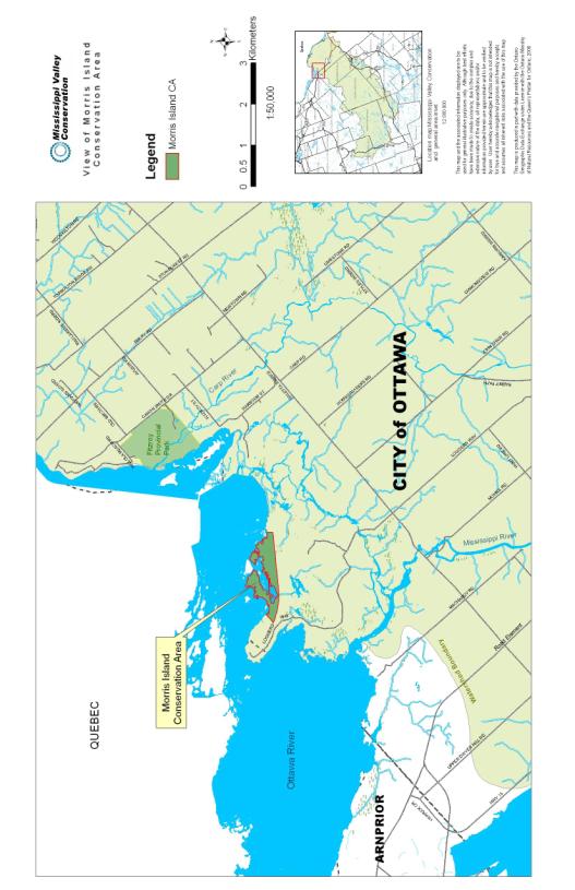
Morris
Island Conservation Area (MICA), a 47-hectare site, is located in former West
Carleton and is jointly owned by the City of Ottawa and OPG. The entire shoreline and approximately
14 hectares is owned by OPG while the remaining 33 hectares belongs to the
City of Ottawa. The site features a
diverse natural environment of wetland and upland areas with beautiful
sheltered bays, small off-shore islands and spectacular scenic views of the
Ottawa River.
Development and maintenance of
the site by MVCA is currently guided by the Morris Island Conservation Area
Master Plan (1987) prepared jointly by the former Region, MVCA and Ministry of
Natural Resources. To date, MVCA has provided
funding for both capital and operating costs associated with the site. While ongoing maintenance costs will
continue to be supported by MVC through the general levy, the projects proposed
in the Morris Island Conservation Area Infrastructure and Capital Improvement
Plan require additional funding over the next three years.
Established facilities on site
support day-use outdoor recreation, including:
-
two main hiking trails, and a wheelchair accessible trail
loop;
-
modern wheelchair accessible washrooms, plus outhouses
(non-wheelchair accessible) along outer trails;
-
fishing platforms;
-
canoe launches; and
-
picnic areas.
In 2003, the City of Ottawa, MVCA
and OPG agreed to re-evaluate the existing Master Plan for MICA and develop a
management plan to guide future work.
This initiative was given added impetus during the consultation process
for the Chats Falls Dam boat bypass project, due to the identified community
support for maintaining MICA for public use.
The City participation was led by Planning and Growth Management, with
input from Community and Protective Services.
DISCUSSION
Morris Island Conservation Area
will be improved and managed to best meet its objective as stated in the
plan: to develop and maintain
opportunities to foster an appreciation of the natural environment and
understanding of water management. By investing in the revitalization of Morris
Island Conservation Area, Council will ensure that Ottawa residents have a high
quality, natural recreation outlet which protects and preserves the natural
heritage features of this significant stretch of Ottawa River shoreline.
Summary of Proposed Plan
The proposed improvement plan identifies capital projects and associated operating costs necessary to replace aged infrastructure and upgrade facilities over the next three years (2007‑2009). The plan also proposes new interpretive and other educational materials and improved marketing of the area to make more people aware of this waterfront resource. The plan also includes an annual maintenance schedule to increase the life cycle of infrastructure and public service/access facilities.
A site assessment by MVC staff
has identified two priority projects which require immediate attention for
appropriate risk management for continued public use of MICA. The first priority consists of replacement
of the culverts within the causeway that cuts across the bay and connects the
two main portions of the conservation area.
These culverts must be replaced as soon as possible in 2007 to ensure
the integrity of the causeway for public safety and to provide continued access
to the more remote trails. Resurfacing
of the causeway would occur in 2008.
Poison ivy control in public
access areas is the second priority to be addressed. The causeway, as the main access trail within MICA, must be
treated for large quantities of poison ivy along the causeway trail edges. Allowing it to continue to thrive unchecked
in this area will result in eventual inevitable contact by the public as the
plants are encroaching into the main pedestrian travel areas. As well, costs to control the poison ivy
will rise over time if not addressed soon.
Other shorter term projects
identified for enhancement of MICA to address public safety needs include
replacement of smaller trail bridges, the fishing platform and trail signage.
In addition to
capital projects, the plan proposes increased marketing of the site and new
educational and interpretive materials.
Visitor surveys in 2005 and 2006 showed most visitors were singles or
couples who hiked full circuits of the trails, with many visiting more than
once per week. Visitors were either
residents of nearby rural communities or came from urban Ottawa, with about
4000 cars per year visiting the site.
The survey showed that visitors are supportive of an admission fee or
annual membership; however, this proposal will be discussed further with the
City.
The plan proposes
to improve driving directions and roadside signs as part of an improved
communications plan. The proposed projects
will make the site more suitable for families and will increase its
accessibility through construction of longer wheel-chair accessible trails, in
addition to upgrading the central accessible washroom facilities.
Eight to 12
interpretive signs will be established throughout the site, along with
demonstration sites to provide examples of best management practices that
visitors could use on their own property.
These could include, for example, shoreline buffers and wildlife habitat
improvement.
Table 1 summarizes all of the projects proposed through the Morris Island Conservation Area Infrastructure and Capital Improvement Plan.
Table 1: Summary of MICA Infrastructure and Capital
Improvement Plan
|
Feature |
Objective |
Projects |
|
Site Management |
Provide a
well managed and maintained site that encourages visitors to access and
experience all aspects of the area |
* replace culverts |
|
Administration/
Communication |
Provide
clear and quality information that encourages and facilitates visits to the
site |
* install
user fee gate * produce
French version of MICA brochure * upgrade
marketing and advertising *
maintain communication with partners * improve
driving directions and signage |
|
Demonstration
Sites |
Provide
examples of conservation techniques related to land and water that can be
applied on private lands |
*
demonstration sites developed as examples of conservation best management
practices |
|
Site
Activities |
Encourage
visitors to immerse themselves in the natural environment, while encouraging
a greater appreciation and understanding of nature |
*
classify trails |
|
Interpretation |
Create
awareness of natural environment and water management issues |
* add
8-12 interpretive signs on conservation topics |
In
addition to these projects, the plan also identifies an ongoing maintenance
schedule and standards with an estimated cost of $17,200 per year. Maintenance will continue to be the
responsibility of MVC. Volunteers are
also active in maintaining and operating the site and visitor donations provide
a small amount ($400 to $650 annually) of additional funding.
ENVIRONMENTAL IMPLICATIONS
Improving visitor facilities and encouraging public enjoyment of this richly diverse natural environment feature in an environmentally sustainable manner will foster public appreciation of the value of preserving natural spaces within Ottawa. The planned interpretative signage and demonstration sites will assist in the City's objectives to enhance public knowledge of natural heritage stewardship initiatives. In addition, completion of this plan contributes to the City's commitment to establish management plans that balance community use with natural environment protection for all of our significant natural heritage features.
Implementation of the proposed improvement plan will enhance user safety and enjoyment at this conservation area, which is extensively used by local residents as well as by other Ottawa residents and visitors.
CONSULTATION
MVCA has conducted visitor surveys
(August-September 2005) and volunteer surveys to determine usage patterns and
elicit input on desired improvements.
City of Ottawa and OPG staff, the Ward Councillor and the Mississippi
Valley Conservation Foundation have also been consulted on the proposed
improvements. MVCA staff presented the
plan to the OFGAC on September 25, 2006 for comment. At the meeting, OFGAC
discussed the proposed improvements to the trails and parking and entrance
area with MVCA staff, and sought clarification regarding the special levy. The recommendation was made that a forest
management plan should be undertaken for the conservation area, and the
improvement plan was amended accordingly.
A more detailed review of the plan by OFGAC members is currently being
undertaken.
FINANCIAL IMPLICATIONS
The improvement plan for Morris Island Conservation Area is recommending projects with a total cost of $237,500 over three years to upgrade infrastructure and improve facilities to enhance public safety and increase the use of the site. MVCA is seeking funding from several sources, including Ontario Power Corporation, potential user fees, and the Mississippi Valley Conservation Foundation. Although OPG, the owner of part of the site, has no mandate for facilitating public use of the area, it may be interested in supporting public education and interpretation on-site regarding OPG. Based on experience at other sites, MVCA also sees potential for $10,000 annually or more in user fees, if these are implemented. The Foundation has also been asked to consider contributions.
MVCA will request special levies
in 2007 to 2009 as part of Council’s annual budget process to support
implementation of the improvement plan. The amount requested each year will depend
on funding secured from other sources, with the MVCA seeking a total of $87,000 from all sources in 2007 to repair
the causeway, improve the parking/entrance area and begin trail rehabilitation
and poison ivy treatments. If Council
approves a special levy, it would be assessed within the MVCA’s area of
responsibility within the city.
SUPPORTING DOCUMENTATION
Document 1 Morris Island Conservation Area Infrastructure and Capital Improvement Plan
DISPOSITION
Planning and Growth Management staff will forward the Council decision on this report to the MVCA and work with the MVCA to secure the funding required for the Infrastructure and Capital Improvement Plan from a variety of sources.
Morris Island
Conservation Area
Infrastructure and
Capital Improvement Plan
2007-2009
Mississippi Valley
Conservation
October 2006
Table of Contents
1.3.1
Provincial and Municipal Designations
Part 2:
Developing the Framework
Part 3:
Management Objectives and Strategies
3.1
Planning Issues & Considerations
Part 4: Site Management Action Plan
4.1
Infrastructure and Capital Improvement Plan Objective
4.4.3 Interpretation/Education
4.4.4 Administration and Communication
Appendix A - Morris Island Conservation Area
Site Map
Appendix
D – Partnership Agreement
Appendix
E – Natural Resource Observation List
Appendix
F – Natural Heritage Information Centre Report
Preface
Morris
Island Conservation Area (MICA) is located on the Ottawa River shoreline in the
City of Ottawa and is owned jointly by the City of Ottawa and Ontario Power
Generation. The shoreline and
approximately 14 hectares is owned by OPG, with the remaining 33 hectares owned
by the City of Ottawa.
The
development of MICA was made possible in 1987 through a partnership with the
City of Ottawa (RMOC), Ontario Power Generation (OPG) and Mississippi Valley
Conservation (MVC). Funding for the initial development was provided by the
Province of Ontario through the Ministry of Natural Resources, the City of
Ottawa (RMOC)and MVC. Development and maintenance of the site by
MVC has been guided by the approved of the Morris Island Conservation Area
Master Plan (1987).
In 2003 the
Ottawa River Project Inc. proposed the construction of a boater’s by-pass
around Chats Falls Power Generating Station on the Ottawa River. One of the development options included the
use of the causeway at Morris Island Conservation Area for vehicles hauling
boats to a launch site. Although the
option is no longer being considered the support from the local community to
maintain Morris Island Conservation Area for public use supported the need to
re-evaluate the management of MICA.
This plan
will guide maintenance and development activities at the Conservation Area
until 2009.
Summary
Objective
The draft
Morris Island Conservation Area (MICA) Infrastructure and Capital Improvement
Plan has been developed to guide improvements to the operation, management and
development of the property. The plan will address current constraints and
identify future site improvement opportunities. Emphasis will be placed on
addressing public needs, and enhancing visitation while maintaining
environmental integrity.
Investing
in the revitalization of Morris Island Conservation Area helps ensure rural and
urban residents of the City of Ottawa have access to a high quality, natural
recreational area along the Ottawa River shoreline. This investment will also
help protect and preserve the natural heritage features of this important,
natural stretch of shoreline.
Background
Morris
Island Conservation Area is located in the City of Ottawa (former Regional
Municipality of Ottawa-Carleton), in Ward 5, formerly West Carleton. The 47-hectare site is a diverse natural
environment consisting of wetland and upland areas with beautiful sheltered
bays, small off-shore islands and spectacular scenic views of the Ottawa River.
(Appendix A)
Development
and maintenance of the site by Mississippi Valley Conservation (MVC) is guided
by the Morris Island Conservation Area Master Plan (1987). To date, MVC has
provided funding for both capital and operating costs associated with the site.
Recent changes in funding have resulted in inadequate funds available to
address upkeep requirements. MVC is currently committed to approximately
$17,000 in annual maintenance expenses.
Site Facilities
Established facilities on site support day-use outdoor
recreation and include:
- Two main hiking trails, and a
wheelchair accessible trail
- Modern wheelchair accessible
washrooms, outhouses (non wheelchair accessible) along outer trails
- Fishing platforms
- Canoe launch
- Picnic area
The draft Infrastructure and Capital Improvement Plan identifies capital projects and the costs necessary to address replacement of aged infrastructure, and incorporate an annual maintenance schedule to increase the life span and viability of MICA.
Target Market
Based on the results of a visitor
survey conducted in the fall of 2005, current users are either local rural
residents of the Vydon Acres community or City of Ottawa urban centre
residents. The existing market consists mainly of young couples and individuals
who walk their dog or enjoy hiking.
Marketing efforts will be directed to: enhance visitation by local
residents; encourage visitation by non-local residents, naturalists groups and
other organizations.
Capital Projects
Site assessment by MVC staff has identified two priority
projects which require immediate attention to address risk management issues.
The draft Infrastructure and Capital Improvement Plan identifies
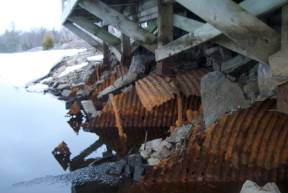
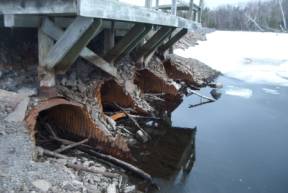
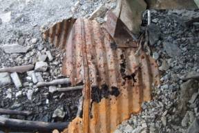
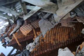
some infrastructure replacement as being an immediate priority. Culverts located in the causeway have
degraded (Figure 1) and must be removed.
A solution to the water crossing must be initiated as soon
as possible to protect public safety by ensuring the integrity of the causeway
and the continued access to the ‘back’ segment of the site including the yellow
and purple trails.
Although a noted food source for resident wildlife, poison
ivy must be controlled in key public access areas. The causeway, as the main access trail, must be treated for large
quantities of poison ivy which are located along causeway edges. Allowing it to continue to thrive unchecked
in this area will result in inevitable contact by the public in the near future
as it encroaches directly into main pedestrian travel areas. This is also a
health and safety issue for maintenance staff working on site. Costs to address
the issue will rise over time if left unchecked.
Replacement of smaller trail bridges, the fishing platform,
and trail signage is a third concern which should be addressed as soon as
possible for public safety. Project
completion is scheduled for the end of 2009 and should be initiated in 2007.
Figure 1 Photographs
illustrating the extent of degradation to the culverts.
|
Infrastructure Repair and Replacement
Costs |
|
|
Project |
Cost $ |
|
Causeway Water
Crossing |
$60,000 |
|
Causeway Resurface |
$16,800 |
|
Rehabilitate Trail
Rest Areas |
$9,300 |
|
Expand Picnic
Facilities |
$21,500 |
|
Improve Parking
/Entrance Area |
$13,600 |
|
Poison Ivy Removal |
$8,500 |
|
Trail Rehabilitation |
$50,200 |
|
Repair Bridges &
Handrails |
$20,300 |
|
Reconstruct
Trail/Wheelchair Accessible Privies |
$18,700 |
|
Install
Educational/Interpretive Signs |
$18,600 |
|
|
|
|
Total |
$237,500 |
Work Plan
Year 1 (2007) $87,000.00
- Causeway water crossing repairs
- Poison ivy treatment 1st application
- Improvements to parking/entrance area
- Begin trail rehabilitation
Year 2 (2008) $80,000.00
- Poison ivy treatment 2nd application
- Finish trail rehabilitation
- Causeway resurfacing
- Repair bridges and handrails
- Install educational/interpretive signs
Year 3 (2009) $70,500.00
- Poison Ivy Treatment 3rd application
if necessary
- Finish rehabilitation of trail rest areas
- Expand picnic facilities
- Reconstruct trail wheelchair accessible privies
- Rehabilitation of trail rest areas
Total $237,500.00
Part One: Site Description
1.1
Background
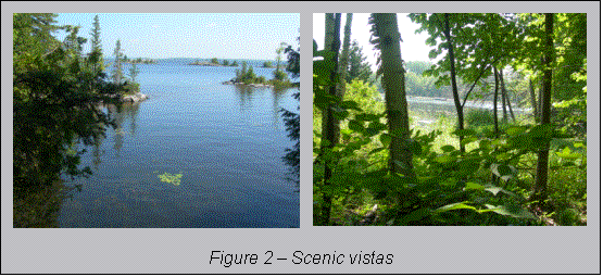
The 47
hectare site offers a diverse natural environment of wetland and upland areas
with beautiful sheltered bays, small off-shore islands and spectacular scenic
views of the Ottawa River. A causeway
bisects the property, providing an access route from the entrance area to the
far end of the property. Trails lead
off the causeway and provide visitors access to forests and shoreline areas.
The
facilities on site have been established to support day-use; self guided
outdoor recreation with two main hiking trails, and a wheelchair accessible
loop. Modern wheelchair accessible
washrooms, outhouses, canoe launch and picnic area are also available to
visitors.
The City of
Ottawa, MVC, and OPG agreed to support an initiative to re-evaluate the
existing Master Plan for MICA and develop a Management Plan to address current
infrastructure requirements and guide future work.
1.2
Cultural History
The area is
rich in history with the Ottawa River and Chats Falls dam, railways, former
mines (Kingdon mines) and voyageurs portaging through the area.
For
centuries the Ottawa River was a major transportation route for voyageurs,
trappers and travelers, and an important route for trade with First Nations.
Morris Island was used as a portage route around Chats Falls. Toward the late
19th century and throughout the 20th, the lumber industry thrived
and the river was used for the transportation of logs. Today pulp and paper
mills exist locally in Arnprior to the west and in Ottawa to the east.
Chats Falls, adjacent to Morris Island, was historically an
obstacle to travel, but because of the waterfall, the village of Fitzroy
Harbour became established as a shipping, milling and logging centre. In 1929
the Chats Falls Generating Station was constructed which to this day generates
electricity for all parts of Ontario.
A
number of mines existed in the area.
Kingdon Mine, located on Morris Island, was a 1400 foot shaft mine
constructed in 1885, producing pig lead, iron ore and zinc concentrates. It has been idle since 1950.
The railway also played
an important role in the historical development of the area. The original railway
line that transected the current conservation area (i.e. the causeway) was
abandoned around 1929 when the construction of the hydro dam began and the area
was flooded. A new rail line was
constructed along what is now the western boundary of the site.
1.3 Natural Heritage
1.3.1 Provincial and Municipal Designations
Morris Island Conservation Area is designated as a
Provincially Significant Area of Natural and Scientific Interest (ANSI) for
Life Science features. The site is
recognized as having considerable natural and environmental value in addition
to its recreational potential, so that permitted land uses are limited.
Flora and fauna studies related to Morris Island (Appendices
E and F) indicate that this area is rich in biodiversity and provides habitat
for a number of significant species of flora and fauna. The creation of a more
comprehensive natural features inventory for MICA will be undertaken. The
presence or absence of significant species will influence certain site
management strategies.
1.3.2 Landform Features
Soils are
shallow in areas, with little overburden and exposed bedrock on many parts of
the site. The site has extensive
outcroppings of marble which results in a unique landform, not often found in
the Ottawa area (Appendix F)
The
underlying rock has also contributed to the development of the many wetlands
found on site. Ground infiltration in
these low-lying pockets is poor and over time wetland vegetation has grown and
these important ecosystems have developed.
These wetlands positively contribute to the water quality of water which
is eventually released into the Ottawa River.
1.3.3 Forest
The
forested area of MICA is typical of the Canadian Shield of Eastern Ontario in
that it consists of dense mixed deciduous/coniferous stands (Appendix F). It is significant in that it is
representative of a marble based forest, with only one other example to be
found in eastern Ontario.
1.3.4 Ottawa River Shoreline
Several
types of ecosystems are found on site that protect, cleanse, and maintain
substantial groundwater supplies including the diverse shoreline along the
Ottawa River and numerous wetland environments.
1.3.5 Vegetation
Several
species of wildflowers abound in the Conservation Area. Those along the causeway are typical of
roadsides or open fields. The forested areas are filled with native
wildflowers and mushrooms including some significant species as outlined in the
Rare Vascular Plants of Ontario.
1.3.6 Wildlife
The
wildlife in the area includes a variety of common mammals such as chipmunks,
squirrels, raccoons and porcupine.
Beaver activity is abundant in certain areas and white tailed-deer are
regularly spotted around the site.
Populations
of pickerel, perch, and pike inhabit the site. The Ottawa River also supports
nationally significant species of fish such as the lake sturgeon and the river
redhorse.
A diverse
bird population also makes MICA a popular birding location. A variety of ecosystems found on site
provide a home for both shorebirds and interior forest species. The red-shouldered hawk, a national and
provincial species of special concern, is known to nest on site.
Many
species of reptile and amphibian occur in the woods and wetlands at MICA,
including the nationally and provincially significant Blanding’s turtle. The causeway is heavily used by populations
of Northern Water Snake for basking in the sun. These snakes can be readily seen along the edges of the causeway
or swimming nearby.
Morris
Island supports a large number of different species of dragonflies including
several provincially significant species.
These, and a number of other aquatic and terrestrial invertebrates, add
to the diversity of life found in the area.
1.4 Facilities
Through the
implementation of the development plans from the 1987 Morris Island
Conservation Area Master Plan the following facilities are currently available
in the Conservation Area.
1.4.1 Hours of Operation
Full access to
the site and washroom facilities is available from dawn to dusk, May 15 to October
15.
Access from October 16 to May 14 is for walking trail use only.
1.4.2 Trails
There are
approximately 6 km of trails throughout the
site each having their own character, diversity and ability to give visitors a
sense of remoteness.
Blue trail leaves from the parking lot and has a 0.5 km
loop which is wheelchair accessible.
The main trail continues on through the forest and along areas of the
shoreline for over 2.5 kilometres, returning to the parking lot. Some small walking bridges are utilized for
water crossings. Short cutoff trails
lead from the main blue trail to scenic viewpoints of the Ottawa River.
Yellow trail begins and ends at the causeway and is
approximately 1.4 km long, passing through the forest and along shoreline in
the eastern half of the site. The trail
is rugged with uneven footing due to slopes, tree roots, and rock. This system includes various short trails to
scenic lookouts and bridge crossings. Yellow trail has an additional loop trail
extending from it to the north, referred to as the purple trail.
A third trail, white trail, is a forest trail without
shoreline access. Due to the 1998 ice
storm and the damage it caused, this trail was closed and has not been
reopened.
The causeway was previously a rail line. It is a wide open, flat gravel trail 1.5 km
long which transects the property. The
causeway links the yellow and white trail systems to the parking lot.
1.4.3 Signage
The site currently offers basic information signs with
trails maps, site rules and trail markers. A trail brochure is available at the
entrance of the site to assist with direction and to provide brief information
about the site.
Directional road signs are in place along
the old access road, Highway 17 and County Road 22. They are also located on Loggers Way Road leading into the site.
1.4.4 Washrooms
A main
washroom is located off the parking lot and outhouse style washrooms are
located throughout the site. Dedicated volunteers unlock and lock the main
washroom on a daily basis during open season (May 15 to Oct 15).
1.4.5 Donations
A sign and
donation box on site requests a donation for each visit. Visitors have the option to purchase a
“Morris Island Supporter Card” with an annual payment. The following chart outlines the revenue for
the past four years. The donation box had been vandalized regularly. MVC staff
has resolved the situation.
|
Year |
Individual Charitable Donation |
Donation Box |
Total |
|
2006 |
$225 |
$421.42 |
646.42 |
|
2005 |
$320 |
$62.68 |
382.68 |
|
2004 |
$225 |
$164.96 |
389.96 |
|
2003 |
$380 |
$194.77 |
574.77 |
1.4.6 Volunteers
Dedicated
local volunteers provide general maintenance and care for the site. During the
regular season they are responsible for ensuring the washroom facilities are
open, closed and clean. They empty the garbage cans weekly and report any
vandalism or equipment failures. They also report any hazards on the trails.
1.5 Management
MVC is one
of 36 Conservation Authorities in Ontario which operates under the umbrella of
Conservation Ontario. Conservation Authorities are local, watershed based
environmental management agencies that deliver services and programs that
protect and manage water and other natural resources in partnership with
municipalities, landowners and other organizations.
MVC owns
and/or manages conservation areas to:
“promote a conservation ethic by
providing opportunities for the public
to experience nature in a variety of unique settings.”
1.5.1 Partnerships
The Region
of Ottawa-Carleton (now the City of Ottawa) originally acquired a portion of
Morris Island due to recommendations in the River
Corridor Study, 1978. The City’s
interest was to provide opportunities for various types of water and land based
recreation for the general public.
The
facilities at MICA directly support the Parks and Recreation objective of the
City which is to deliver quality programs and services to enhance residents’
quality of life and encourage an active and healthy lifestyle.
Ontario
Power Generation is committed to strengthening their relationship with the
communities they serve and enhancing the quality of life in the areas where
they operate. OPG is committed to
assisting with providing education at the site for visitors to experience.
MVC
provides leadership in managing water resources within the Mississippi Valley Watershed
in partnership with member municipalities, resource agencies and watershed
communities.
MVC has
monitored and maintained MICA since the inception of the Management Plan
(1987). Trail maintenance, facility and
infrastructure development, and general coordination of volunteer support has
been financed and carried out by MVC staff.
MVC will continue to work with partners to ensure the integrity of the
site is retained and the site continues to be made accessible to the public.
Part 2:
Developing the Framework
2.1 Statement of Purpose
The funding
environment with which conservation areas, including MICA, were originally
developed has changed in the last decade.
As a result, there is a need to determine new funding sources and
agreements to maintain these areas.
With MICA there is a need to increase funding to the site in order to
ensure that a standard of safety and quality is achieved for the experience of
the visitor and the sustainability of the site.
A review
process was initiated to plan the best uses of the site and identify the needs
of the site. New plans for the site are
consistent with the original master plan but are modified and refined where
needed to adapt to current and projected use.
This process will create a new management strategy for MICA that strives
to provide a site for visitors to experience a unique natural environment where
good land stewardship practices related to water resources are represented and
demonstrated.
2.1.2 Key Principles
The
ecological diversity that exists at MICA makes it an ideal destination to
experience and learn about nature and the history that surrounds it. Each unique ecosystem must be managed in
such a way as to protect the natural features and functions, while providing
opportunities for visitors to experience them.
Every corner along the trail provides a different environment, another
scenic vista of the Ottawa River with a sense of semi-wilderness. There are also small sheltered bays along
the trails that offer up-close experiences of small natural environments.
2.1.3 Current usage
Through
observation of current uses, opportunities to further develop the site in a way
which will address user risk factors and enhance visitor experiences while
protecting key ecological features and functions can be recognized and acted
upon. Information from observation and
on-site knowledge of current uses was enhanced by collecting information from a
number of sources, including public consultation.
Water
recreation in the conservation area is recommended in the bay area only as
water levels can be greatly affected by fluctuations from the operation of
Chats Falls Generating Station. This in combination with strong currents poses
a safety concern for swimmers and boaters (canoe and kayak).
2.2 Market Analysis
The communities of Galleta and Fitzroy Harbour adjacent to
Morris Island Conservation Area have traditionally been agricultural or
resource based. The land in the
immediate vicinity was mined, and more recently has slowly evolved as a
residential area.
The region as a whole has strong recreational and tourist
appeal. Much of the waterfront properties along the Ottawa River within the
City of Ottawa have been developed for seasonal residence but are increasingly
becoming permanent residences. This pattern of development around the area is a
reason for the protection of some of the remaining shoreline property for
public use and this area will become increasingly important to the public.
The Morris Island community is rapidly
expanding and further residential development is being proposed. Not only does the increase in development
augment the numbers of potential users of MICA, it also reinforces the need for
providing adequate protection for remaining natural areas. Serious
consideration should be made to coordinating all properties in the area which
are open space and/or have natural values, as this will provide added value to
both the local residents and visitors.
This is consistent with the City of Ottawa’s Official Plan, which
currently has a Greenspace Master Plan in place for areas within the urban
boundary and plans to develop one in the near future for rural areas. Schedule
A of the Official Plan, The Rural Policy Plan, identifies the areas in
and around MICA as Natural Environment Area, Major Open Space and Rural Natural
Features Area.
2.3 Public Consultation
2.3.1 Visitor Surveys
Surveys were distributed on site in
August and September of 2005. The surveys were mainly available during summer and
fall weekends, several summer weekdays and were also distributed to
volunteers.
The surveys completed revealed:
°
the majority of visitors are either one or two people
°
many visitors are regular patrons of the site
°
most visitors go to the site to walk with or without a
dog
°
visitors tended to walk a whole section of one of the trail
systems per visit
°
many would do so several times a week
°
average time spent at the site is around two hours
The Blue trail and Causeway appeared to get the most use
with usage of the Yellow trail being marginally less.
Requests for upgrades/improvements made through surveys:
°
improve directional signage such as trail markers and trail
signs
°
deal with poison ivy
°
site maintenance items, including vandalism
°
new picnic areas
°
interpretive information
°
rest stops
°
relocate canoe launch
Most survey responses supported methods to recover costs for the site through
volunteering, implementing user fees and annual memberships
There is potential to actively market Morris Island as a
destination as the majority of the visitors discovered the site through road
signs or they live nearby. Most of the visitors beyond the
local community are from the City of Ottawa.
Consultation also included Mississippi Valley Conservation
Foundation, a charitable organization dedicated to supporting various
Conservation Authority projects.
2.3.2 Target Markets
The
existing market mainly consists of young couples/individuals, dog walkers and
hikers, urban and local rural residents.
There are
many organized naturalist groups which use the site due to the natural
diversity. Many more groups exist which
would enjoy and benefit from the natural features of the site. Greater emphasis will be put on marketing to
those groups through presentations to local groups, posters and brochures.
Through
this Infrastructure and Capital Improvement Plan, the site will be upgraded to
appeal to young families and as a result, a broader range of rural and urban
visitors.
Surveys
revealed that visitors were attracted to MICA for the uniqueness of the site
with a special interest in the natural features. The majority of the visitors hike on the trails and appreciate
the solitude the site provides.
2.3.3 Review
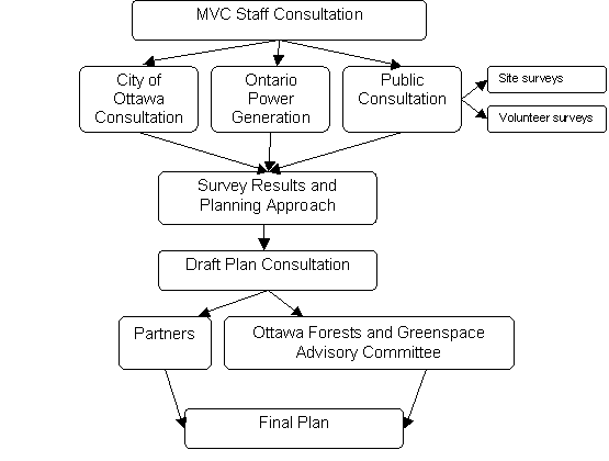
The following process was undertaken
to ensure adequate input.
.

Part 3:
Management Objectives
and Strategies
3.1 Planning Issues & Considerations
- The total acreage of the
conservation area is relatively small in relation to major parks (ie.
Gatineau Park). The facilities
extend throughout the majority of the land, so consistent consideration
must be made to the integrity of the land, with respect to wetlands and
other natural features.
Improvements and management must be planned in such a way as to
protect the natural features where necessary and to utilize the natural
features in a sustainable way.
This will be the first priority during planning and implementation.
- Trails, especially the Yellow
trail, are situated in areas in which the natural features can be easily
degraded. Locating trails on steep
slopes must be avoided as vegetation can more easily die off and result in
soil erosion and general degradation of the area.
- Sensitive natural areas within
the site such as wetlands or significant wildlife habitat must be
identified prior to site planning approvals. These sites will then be given consideration when placing
trails or planning activities in the vicinity, to ensure that there will
not be disruption or degradation of ecosystem processes.
- A forest management
prescription will be updated in 2006.
Consideration of access to various parts of the site for fire or
other emergency response should also be developed.
- Shoreline management will
include current Best Management Practices (BMPs) to ensure protection of
aquatic habitats and shoreline vegetation.
- Unauthorized motorized vehicle
usage has been a concern to users for many years. The result of this activity is
vandalism of the gates, deterioration of the trails and conflict with
conforming users. The challenge is
that options available to restrict motorized uses also restrict wheelchair
access.
- Unauthorized uses, such as
night parties and bonfires must be addressed. Access restriction during off hours through gating the
entrance will address some of these issues but further work should be
done, in conjunction with Ottawa Police, to reduce this problem.
- The spread of poison ivy has
become an increasing concern, especially with young families. With reduction of trail bases,
restrictions on treatment, and access to remote areas, the poison ivy
populations are increasing and becoming a greater concern to visitors,
volunteers and staff.
- The existing boat launch is a
considerable distance from the parking lot but is the closest access to
safe waters which are not affected by fluctuations related to Chats Falls
Generating Station. Suitability of the launch site and access should be
reviewed.
- The site must be designed in
such a way as to minimize future overhead costs or generate new
revenue. Staffing constraints
should be recognized, as staff is not on site daily to maintain the
facilities or supervise users.
- Volunteers have been an
integral part to the management of the conservation area. The main office for MVC is a
considerable distance from the area and volunteers have performed daily
maintenance for several years.
Changes to the site have to be carefully considered so that added
responsibility is not required of the volunteers.
- Integrated site planning will
ensure that ecological site integrity is maintained while addressing best
use of the site and utilizing risk management methods to maintain public
safety.
Part 4: Site
Management Action Plan
4.1 Infrastructure and Capital Improvement Plan Objective
Through a
review of the past objectives and consideration of the changes since their
development, Morris Island Conservation Area will be developed and managed to
best:
“Develop and maintain opportunities to foster an appreciation
of the natural environment and understanding of water management.”
A long term
objective of this plan is to not only provide demonstration sites which offer
the public education on sustainable practices, but to develop and maintain the
site in such a manner that demonstrates that we ‘practice what we preach’.
4.2 Site Development
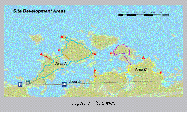
For planning purposes, the site has been broken up into
three areas, A, B, and C. Area A
facilities and trails will be enhanced to facilitate general uses and will have
the heaviest volumes of visitors. This
area includes the parking area, picnic area, blue trail, associated scenic
lookout (red) trails and the surrounding forest and shoreline. Area B is the causeway going over the bay
and will be used as access to Area C as well as for access for fishing and
aquatic observation. Area C will be an
area with fewer facilities and a more rugged trail system to appeal to
naturalists and visitors who enjoy the opportunity to go ‘off the beaten
track.’ Area C is the causeway past the
bay, the yellow, purple and white trails, associated red trails, and the
surrounding forest, wetlands, and shoreline.
Area A
There are a number of opportunities to provide enhanced
access to trails and services. In an
effort to make the facility more appealing to families and visitors traveling
from the adjacent urban and suburban areas, the site will be enhanced to
provide different levels of trails and facilities.
The area adjacent to the parking area currently has a small
picnic facility and wheelchair accessible washrooms. The existing picnic area will be upgraded. More picnic tables will be available and the
picnic sites will be cleared for easier access and to provide direct sight
lines from these areas to the parking area.
Poison ivy in this area will be eradicated.
The blue trail is also in the proximity of the parking area
and a portion of this trail is currently leveled and defined by stone
dust. This trail will be upgraded and
will appeal to families as it will have easy access, be relatively short, and
be well signed. Initial interpretative
information will be developed for this trail and it is expected that this area
will receive the greatest volume of visitor traffic.
A forest management plan will be prepared in conjunction
with City of Ottawa staff to ensure proper management of this area, as well as
Area C. This plan may include a fire
management plan, which will address fire risk and access issues. The fire management plan may be developed in
conjunction with Ministry of Natural Resources.
Area B
The causeway provides the sole connection between the
‘front’ portion of the site (Area A) and the ‘back’ portion of the site (Area
C). It provides visitors a glimpse of
the River and gives them an opportunity to observe aquatic life in the
sheltered bay.
This area requires immediate infrastructure replacement.
Culverts which allow water and fish movement and join the two areas of the bay
which are otherwise separated by the causeway are aged and may collapse. The fishing platform is currently placed
over these culverts and requires a stable base structure as well to ensure its
integrity.
Poison ivy is spreading in this area and must be
eradicated. The slopes of the causeway
will be re-vegetated with native species, which will define the traveled area
of the causeway, reduce erosion, and extend the life of this important link.
Area C
The forest in which the yellow, purple, and white trails are
located is a mixture of upland vegetation species and wetlands.
The yellow and purple trails will be identified as more
rugged trails. These trails provide the
visitor with an opportunity to experience the forest and Ottawa River shoreline
and observe flora and fauna of the area.
Signage for these trails will be upgraded.
A forest management plan will be developed/upgraded in
conjunction with City of Ottawa Forestry Services staff and Mississippi Valley
staff to ensure the long term health of this fragile forest area and to provide
guidance in future development of trails in this area.
The white trail will remain closed. This decision will be reviewed in five years
(in 2011) and resources available for clearing, signage, and maintenance will
be re-assessed at that time.
4.3 Site Management
Management tasks for the site will be developed annually by
the managing partner, currently MVC, and will be reviewed by all partners. Key
maintenance issues will be identified and addressed as well as plans to develop
and upgrade facilities as per this plan.
Funding, for both operating costs and capital improvements, will be
determined annually.
Operating budgets should include provision for managing
partner staff to do weekly site visits to carry out minor repairs and travel to
the site to perform risk identification (ie. damaged or high risk trees) in
main public access areas.
4.4 Plan Objectives
The plan is a three year document. The partner in charge of
site management, currently MVC, will prepare annual updates and budgets as the
plan unfolds.
Projects included in this plan will address one of the
following program objectives:
1)
Site
Management –Provide a well managed and maintained site that encourages visitors
to access and experience all aspects of the area.
2)
Site
Activities - MICA will encourage visitors to immerse themselves in the natural
environment, while encouraging a greater appreciation and understanding of
nature.
3)
Interpretation
–Provide information and demonstration sites to create awareness related to the
natural environment and water management.
4)
Administration/Communication
–Provide clear, quality information that encourages and facilitates visits to
the site.
5)
Marketing
– Promoting the site (e.g., media, events, brochures, posters)
4.4.2 Trail Classification
There are
four types of trails at Morris Island:
Access
trails – include
the causeway and a loop from the parking lot around the main washrooms back to
the causeway. These trails are
wheelchair accessible and are identified with blue markers with a wheelchair
symbol.
Family
trails – will be
stone dust based trails providing mobility for wheels but due to natural
terrain, some slopes may warrant caution.
They are ideal for strollers and portions can be accessed by
wheelchairs. These trails are
identified with plain blue markers and the complete loop is approximately 2.6
km in length.
Walking
trails – are
located on the far end of the causeway.
They will be natural, fairly flat woodland trails allowing for ease of
walking. These trails are identified by
yellow markers on the north side of the causeway and by white markers on the
south side of the causeway. The yellow
loop is approximately 2 km and the white loop is approximately 1.5 km in
length.
Hiking
trails – the purple
hiking trail is located off of the yellow trail and is a naturally rugged,
stony trail. It is the style of trail
that has traditionally been available at MICA and represents natural terrain. The purple loop returns to the yellow trail
and is approximately 1km in length.
4.4.3 Interpretation/Education
MICA is a
“living classroom and laboratory”, and a great place for outdoor education. It
is the perfect medium to communicate the value of sustainable management. Through MICA visitors can learn, be
encouraged and empowered to conduct their own activities in an environmentally
responsible manner.
The site
currently focuses on self guided education, however could be developed to
accommodate operational outdoor education programming should the need arise.
MICA could function in coordination with the Education Programs MVC currently
offers at the Mill of Kintail Conservation Area.
Approximately
8-12 bilingual interpretive signs will be established throughout the site that
will cover conservation topics related to core conservation programs and water
management.
Signs will
include, but will not be limited to the following topics:
·
MVC/CA
- by the picnic area off the blue trail.
·
History
- along the accessible trail with a view of the water.
·
Wetlands
·
Planning/Regulations
·
Source
water protection
·
Groundwater
·
Hydrologic
cycle
·
Tree
cover
·
Watersheds
·
Messages
from the City of Ottawa
·
Dam
History and Safety
The signs
will be similar interpretive signs (graphics included), constructed to be
resistant to vandalism and professional in appearance. The role of each partner applicable to each
interpretive topic will be included on some of the signs.
Demonstration
Sites
The
objective of demonstration sites will be to provide examples of best management
practices, which visitors could be encouraged to apply to their own lands. The site will also become more aesthetically
pleasing in an environmentally friendly manner. Each project will include
interpretive signs that will explain the issue, solution, directions on how to
implement the project on private lands, where to acquire materials, time to
implement, approximate costs and maintenance.
·
A
demonstration site for shoreline buffer examples will be constructed at the
first picnic area near the main washrooms.
·
Wildlife
Habitat improvement with interpretation – brush piles, rotting logs, etc.
4.4.4 Administration and
Communication
- User Fees: A user fee machine
will be put in place with a nominal fee for parking and use of the
site. Season passes will be
available to regular visitors as a one time cost purchase. Passes will be allocated annually to
volunteers.
- A French version of the
conservation area brochure will be developed and available on site as well
as other locations.
- Marketing and advertising will
be improved to provide information for potential and existing visitors.
o
Advertising:
the French and English brochure will be distributed to the NCC Information
Centres within the City.
o
The
MVC and City of Ottawa website will include brief information about the site
and driving directions.
o
Newspaper
ads in Ottawa papers (Kanata, Stittsville, etc.) will provide awareness that
the site has opened for the year and during fall colours.
o
Poster
to go to outdoor stores and health centres, etc. in the City.
o
Signs
from Highway 417 at the Kinburn Side Road will be purchased which include a
ramp sign off of the highway. Trail
blazer signs at Kinburn Side Rd and highway 17and at Galetta Side road and 17
will also be constructed. Additional
signs leading directly to the site will be added at all intersections.
|
Feature |
Objective |
Projects |
|
Site
Management |
Provide a
well managed and maintained site that encourages visitors to access and
experience all aspects of the area |
°
replace
culverts °
replace
fishing platform °
eliminate
poison ivy °
improve
accessible washroom facilities °
widen
and clear trails °
replace
and upgrade trail markers °
remove
entrance gates °
replace
bridges along the trails. °
improve
lookouts, picnic areas and rest spots |
|
Administration/
Communication |
Provide
clear and quality information that facilitates encourages and facilitates
visitors to the site |
°
install
user fee gate °
produce
French version of Conservation Area brochure °
upgrade
marketing and advertising °
improve
driving directions and signage °
maintain
communication with partners |
|
Demonstration
Sites |
Provide
examples on conservation techniques related to land and water that can be
applied on private lands. |
°
demonstration
sites developed as examples of conservation best management practices |
|
Site
Activities |
Encourage visitors to immerse themselves in
the natural environment, while encouraging a greater appreciation and
understanding of nature |
°
classify
trails °
improve trail maintenance °
improve
directional signs |
|
Interpretation |
Create awareness of natural environment and
water management issues. |
°
8-12
interpretive signs added on conservation topics |
Appendix A – Morris
Island Conservation Area
Appendix B - Maintenance
Schedule
May to
October – once a week, one or two individuals, half day to full day.
-
check
trail loop document any work or what was inspected
-
replace
trail markers as needed
-
empty
garbage
-
clean
washrooms and restock
-
check
for poison ivy
-
check
parking passes and remove money
-
develop
an agreement for grading
-
clean
and inspect signs
-
inspect
trail conditions
Estimated Expense - Labour:
$5,175.00, Mileage: $1,840.00 & Equipment: $4,140.00
Winter
maintenance – Monthly inspection (two individuals – full day visit)
-
check
hazards along trails – four wheel tracks
-
check
outhouse washroom – stock toilet paper and shovel
-
check
parking meter (remove any money)
-
develop
agreement with City for plowing
-
monitor
non-conforming use (4 wheelers/snowmobiles)
Estimated Winter Maintenance Expense-
Labour: $1,575.00, Mileage; $560.00, Equipment: $1,260.00
Annual work
– to open in spring (two individuals, maximum one week)
-
general
brushing of the site (entrance, causeway, parking lot, lookouts)
-
full
trail inspection, bridges, trees, trail base, etc.
-
revisit
plan and maintenance schedule; identify shortfalls and areas that can be
improved.
-
replace
trail markers, signs as needed
-
trail
base
-
demonstration
sites, interpretive signs
-
check
on painting needs
Estimated Annual work- Labour:
$1,125.00, Mileage: $400.00, Equipment: $900.00, Supplies: $200.00
Total Annual Maintenance Costs: $17,175.00
Maintenance Standards
a) All hazards
will be minimized (i.e. hazard trees directly along the trail)
b) The site will be developed to be a user
friendly site with proper accessibility including 1.3 meter wide trails, a
solid base for wheelchair trails and consistent maintenance of trail markers
c) All
facilities will be designed and developed with consistent construction and
appearance to other C.A. facilities and can be easily maintained so they will
reflect well on the site.
d) A
regular maintenance routine will be established and adhered to on an annual
basis – See schedule above
e) All wood construction will be eastern
white cedar
Signs
- Large Name sign at Entrance to
main gate
- The site rules are posted on a
sign at entrance to the site:
- This is an
unsupervised site, use at your own risk.
- No hunting, power boats or
motorized vehicles allowed.
- Use marked boating areas
and nature trails.
- Keep grounds clean, use
provided picnic areas and garbage bins.
- No overnight camping
permitted.
- Scoop up after and control
your pets.
- Large Map at Entrance
- Volunteer Appreciation –
listing the names of volunteers
- Two small maps at main entrance
to each trail
- Lookout name signs – a,b,c,d,e
on the yellow trail, 1,2,3,4,5 on the blue trail.
- Intersection directional signs
for trail intersections
- Causeway signs
- Trail markers
- Canoe launch safety sign
Appendix C - References
Morris Island Conservation Area Master
Plan, Mississippi Valley Conservation, December, 1987.
Mississippi Valley Conservation Strategic
Plan 2002, Mississippi Valley Conservation.
Opportunity and Constraint Mapping for
Morris Island, Kingdon Holdings Ltd. August 19, 2005.
Fitzroy Harbour Boat Ramps and Bypass
Environmental Assessment, Robinson Consultants, November 2003.
Visitor Survey, Morris Island
Conservation Area, Mississippi Valley Conservation, 2006
The Conservation And Related Land
Management Strategy, Mississippi Valley Conservation, 1986.
Planning Department, Mississippi Valley
Conservation, 2006.
Natural Areas Report: Morris Island
Conservation Area, Natural Heritage Information Centre http://nhic.mnr.gov.on.ca/MNR/nhic/areas/areas_report.cfm?areaid=1440,
accessed June 14, 2006
Appendix
D – Partnership Agreement
- Planning and development of
Morris Island is done in coordination with the City of Ottawa,
Mississippi Valley Conservation and Ontario Power Generation.
- An annual budget and
development budget will be prepared by and reviewed by MVC and the City
of Ottawa.
- Late winter review of the
Master plan will aid in preparing for the upcoming year’s work. This will be done in coordination with
the City of Ottawa and input from staff and volunteers.
- The City of Ottawa will
continue to maintain road conditions into Morris Island Conservation Area
(plowing, sanding, grading, etc.)
- All maintenance staff will
report to the Field Operations Foreman who reports to the Operations
Supervisor.
- The supervision of Morris
Island is the responsibility of the Community Relations Coordinator, who
reports to the General Manager.
- The volunteer organizer
reports to MVC’s Operations Supervisor.
- MVC will increase maintenance
to the site during all four seasons as per Appendix B.
o
At
each conservation area, summer staff will be orientated on visitor information
related to Morris Island and brochures will be available.
Appendix E – Natural
Resource Observation List
Inventory
for Morris Island Conservation Area as documented in the 1988 Master Plan List.
Species indicated may or may not still be present.
WILDFLOWERS
FALSE
SOLOMON'S
SEAL
SOLOMON'S
SEAL
CLOSED GENTIAN NORTHERN BEDSTRAW
COMMON PLANTAIN ORCHID
SPOTTED JOE-PYE WEED HELLEBORNE
RAGWEED LADY FERN
SPINY-LEAVED SOW THISTLE MAIDENHAIR FERN
MUSHROOMS
QUEEN ANNE'S
LACE PUFF BALL
POISON IVY MINT
MILKWEED RED BANEBERRY
CLIMBING
BITTERSWEET WHITE SNAKEROOT
PURPLE
LOOSESTRIFE SNAKE GRASS
COMMON MULLEIN MOSS
CROWN VETCH SHINLEAF
TURTLE HEAD GOLDEN ROD
COMMON STRAWBERRY SPRUCE MOSS
SPOTTED
TOUCH-ME-NOT ROSE TWISTED
STOCK
BUTTER AND EGGS BLACK
SNAKE ROOT
COMMON ST.
JOHN'S WORT BRACKEN FERN
LANCE-LEAVED
GOLDENROD WILD ROSE
LADY'S THUMB BLEEDING HEART
OXEYE DAISY CLUB MOSS
SILVER ROD CANADA
MAYFLOWER
RED TOP WHITE WOOD ASTER
HEDGE BINDWEED GRAPE FERN
VIPER'S BUGLOSS FLAT TOPPED
WHITE ASTER
SNEEZEWEED CATTAIL
BLADDER CAMPION BEECHDROP
BURDOCK COMMON MOONSEED
STIFF ASTER TWINFLOWER
LARGE
LEAVED ASTER IRIS
TRILLIUM HONEYSUCKLE
SWAMP GRASS HOG
PEANUT
GIANT
REED PURPLE
FLOWERING RASPBERRY LADY’S SLIPPER
SENSITIVE FERN LOPSEED
GROUND
PINE POLYPOD
LOBE
LEAVED HEPATICA YELLOW LADY
SLIPPER
INDIAN PIPE CLOVER
PICKEREL
WEED ROUND LEAVED
ORCHIS
LABODOR
TEA THIMBLEWEED
WATER
TAPE GRASS MORNING GLORY
RIVERBANK
GRAPE CANADA DWARF
CINQUEFOIL
HAWTHORNE
BUR CUCUMBER
TREES
POPLAR BALSAM
SUGAR MAPLE BIRCH
WHITE ASH RED OAK
WHITE ELM BALSAM FIR
BEECH STRIPED
MAPLE
SILVER MAPLE STAGHORN SUMAC
WHITE PINE JUNIPER
WHITE SPRUCE WHITE CEDAR
BLUE BEECH SPECKLED ALDER
BITTERNUT
HICKORY BASSWOOD
WHITE OAK BUR OAK
ROUND LEAVED
DOGWOOD ALTERNATE
LEAVED DOGWOOD
LARGE TOOTHED
ASPEN TREMBLING
ASPEN
WILLOW HOP HORNBEAM
(IRONWOOD)
BIRDS
RED SHOULDERD
HAWK GREAT
BLUE HERON
PILEATED
WOODPECKER BLACK CAPPED
CHICKADEE
SPARROW SPECIES BLUEJAY
RING BILLED GULL RED-WINGED
BLACKBIRD
ROBIN CANADA GOOSE
CROW BLACK DUCK
OVENBIRD VEERY
BLACK THROATED
BLUE WARBLER PILEATED
WOODPECKER
WHITEBREASTED
NUTHATCH YELLOW
BELLIED SAPSUCKER
SQUIRREL PORCUPINE
WHITE TAILED
DEER BEAVER
MUSKRAT CHIPMUNK
RACCOON
REPTILES AND AMPHIBIANS
GARTER SNAKE
NORTHERN WATER
SNAKE
SMOOTH GRASS
SNAKE
LEOPARD FROG
BULLFROG
Appendix F – Natural
Heritage Information Centre Report
![]()
![]()
MORRIS ISLAND CONSERVATION AREA INFRASTRUCTURE AND
CAPITAL IMPROVEMENT PLAN
PLAN D’AMÉLIORATION DES IMMOBILISATIONS ET
DE L’INFRASTRUCTURE DU SECTEUR DE PROTECTION DE LA NATURE DE L’ÎLE MORRIS
ACS2006-PGM-POL-0057
Ms. I. Price, Chair of the Ottawa Forests and Greenspace Advisory Committee (OFGAC), was present in support of the report. She also provided a written submission, which is held on file.
A PowerPoint presentation from Mississippi Valley Conservation Authority was distributed to members and is held on file with the City Clerk.
That the Agriculture and Rural Affairs
Committee recommend Council:
1. Approve,
in principle, the Morris Island Conservation Area Infrastructure and Capital
Improvement Plan, attached as Document 1, subject to the Mississippi Valley
Conservation Authority being able to secure sufficient funding for its
implementation;
2. Direct Planning and Growth Management
staff to work with the Mississippi Valley Conservation Authority to secure the
funding needed to implement the Morris Island Conservation Area Infrastructure
and Capital Improvement Plan from a variety of sources including but not
limited to a request for a special levy in 2007, 2008 and 2009, that would be
considered by Council as part of the annual budget process.
CARRIED