1.
PLAN OF SUBDIVISION - 1520
OLD PRESCOTT ROAD
PLAN DE LOTISSEMENT – 1520, CHEMIN OLD PRESCOTT
|
COMMITTEE
RECOMMENDATION
No Committee Recommendation
RECOMMANDATION DU COMITÉ
Aucune recommandation du comité.
Documentation
1.
A/Deputy
City Manager, Planning and Growth
Management report dated 17 October 2006 (ACS2006-PGM-APR-0232).
2. Extract of Draft Minutes 35,
Agriculture and Rural Affairs Committee meeting of October 26, 2006.
Report
to/Rapport au :
Agriculture and Rural Affairs Committee
Comité de l’agriculture et des questions
rurales
and Council / et au Conseil
17 October
2006 / le 17 octobre 2006
Submitted by/Soumis par : John L. Moser,
Acting Deputy City Manager/Directeur municipal adjoint par intérim,
Planning and Growth Management / Urbanisme et
Gestion de la croissance
Contact Person/Personne ressource : Karen Currie,
Manager / Gestionnaire, Development Approvals / Approbation des demandes
d'aménagement
(613)
580-2424, 28310 Karen.Currie@ottawa.ca
|
SUBJECT: |
PLAN of subdivision - 1520 Old
Prescott road (D07-16-03-0047) |
|
|
|
|
OBJET : |
REPORT RECOMMENDATION
That the Agriculture and Rural Affairs Committee recommend Council refuse a draft Plan of Subdivision for 1520 Old Prescott Road.
RECOMMANDATION DU RAPPORT
Que le Comité de l'agriculture et des questions
rurales recommande au Conseil de rejeter une proposition de plan de lotissement
pour le 1520, chemin Old Prescott.
BACKGROUND
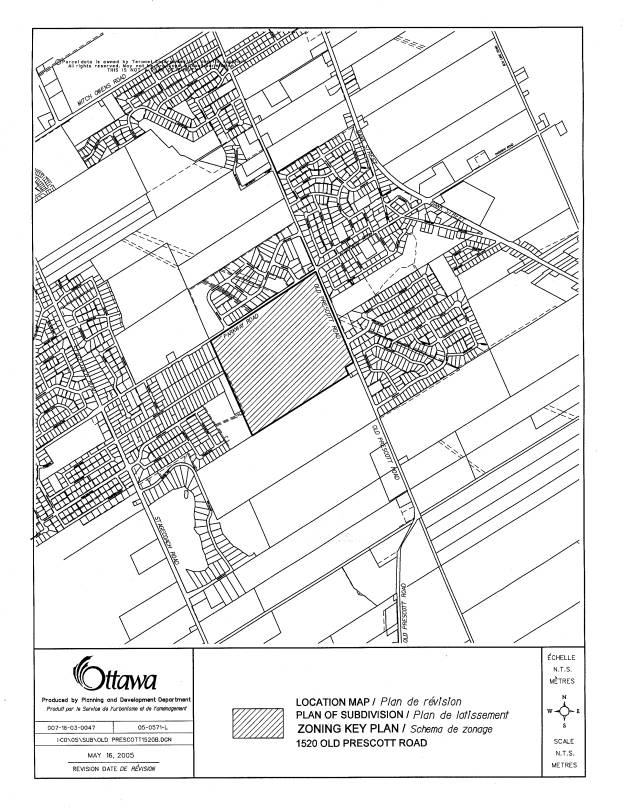
The subject lands are located on
the southwest quadrant of Old Prescott Road and Parkway Road. The site is rectangular in shape and is
currently used for agricultural purposes and has a residential dwelling. The lands are known as the "Quinn
Farm". The surrounding area
consists of commercial/industrial uses to the north (Greely Industrial Park)
across Parkway Road, residential uses (Shadow Ridge) and Andy Shields Park to
the east across Old Prescott Road, future residential subdivisions to the south
(Cadieux Subdivison) and existing residential subdivisions to the west (Stanley
Park).
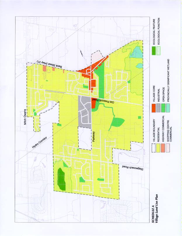
The lands are designated as “Village” in the 2003 Official Plan. The intensity and distribution of land uses within a Village is to be determined in the context of a community design plan and the ability to support development on private water and wastewater services. The Department initiated the Greely Land Use and Design Study (Greely LUDS) in February 2003 to develop a comprehensive land use vision and plan for the Village of Greely. A Steering Committee was created and an open and collaborative process for public consultation commenced with the first workshop on April 15, 2003 and the final preferred report being prepared in May 2004. The applicant actively participated in the Community Design Plan process which was approved by Council on February 23, 2005.
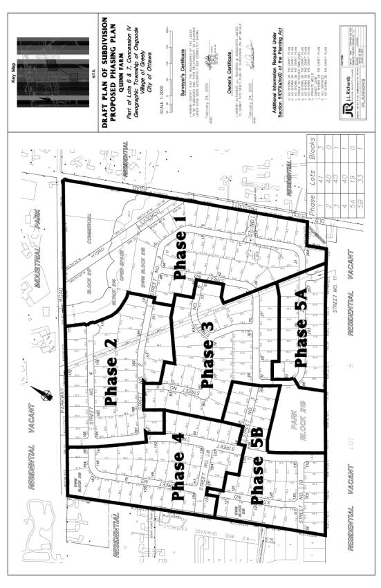
During the preparation of this Community Design Plan, an application for plan of subdivision approval was submitted (September 29, 2003), which consisted of a 40-lot residential subdivision within the core of the Village of Greely on 1520 Old Prescott Road. The proposed average lot size was 0.23 hectares each with private on-site services. The area of the proposed subdivision was 11.62 hectares from the larger 76.64 hectare property. During the review of this draft plan of subdivision, staff requested that a plan be prepared showing the ultimate use of the lands and that the applicant seek approval of the overall plan and then phase the development.
On
March 11, 2005, the applicant submitted a revised application for plan of
subdivision approval for the entire 76.64 hectares in light of the Community
Design Plan. The revised plan of
subdivision consists of 213 lots for single detached dwellings, a Village Core
commercial block at the north-east corner, a community park block in the south
end of the development, stormwater management areas and open space around
Shields Creek. The average residential
lot area being proposed is 0.23 hectares.
The Ward Councillor has withdrawn delegated authority from staff for Subdivision Approval of these lands.
DISCUSSION
Official Plan and Village of Greely Community Design Plan (CDP)
The Official Plan (OP) designates the lands as Village and the intensity and distribution of land uses is to be determined in the context of the Council approved Greely Community Design Plan and the ability to support development on private water and wastewater services. Single detached dwellings are the principal use permitted in the Residential designation. Given the hydrogeological conditions within Greely, it is anticipated that lot sizes will be 0.2 hectares in size or greater.
In addition to addressing private water and wastewater servicing, the applicant was required to submit a Transportation Impact Study to evaluate impacts on the transportation network in the surrounding area, an Archaeological Resource Assessment as a portion of the site was identified as an area with archaeological resource potential, a Tree Retention and Planting Study in accordance with the Shields Creek Subwatershed Study, an Environmental Site Assessment as well as a Stormwater Site Management Plan.
The plan of subdivision submission was reviewed against the policies of the Greely Community Design Plan and policies in the OP. The majority of the required studies in support of the application for plan of subdivision approval were found to be acceptable or could form part of conditions of approval. In general, the residential layout and land uses are consistent with the Greely Community Design Plan in that the development proposes an interconnected road pattern promoting permeability and choice of movement. A Village Core area close to the intersection of Old Prescott Road and Parkway Road, a community park as well as a creek corridor along both sides of Shields Creek have been included.
Private Water and Wastewater Servicing
According to the servicing policies in the Greely CDP, all development must be in accordance with the “Private Water and Wastewater Servicing” policies of the OP and will be reviewed in accordance with the current guidelines for hydrogeological and terrain analyses studies. Final subdivision design will conform to the requirements of the approved hydrogeology and terrain analysis study.
The City will therefore require sufficient information with the development application to assess the likelihood that:
· Sufficient quantity of groundwater exists on site to service the development;
· A water well can be constructed on the proposed lots that will not be impacted by identified potential sources of groundwater contamination in the area;
·
The quality of groundwater is acceptable;
·
The operation of the on-site wastewater system on the
new lot(s) will not adversely impact on a well to be constructed on the
proposed lots and on the wells of neighbouring properties.
The applicant’s engineering consultant, Houle Chevrier Engineering Limited (HCEL), submitted a hydrogeological report entitled “Hydrogeological Investigation and Terrain Evaluation, Proposed Quinn Farm Subdivision, Part of Lots 6 and 7, Concession IV, Village of Greely, Ottawa, Ontario” dated February 2005. The report was received on April 22, 2005 and was reviewed by the Conservation Partners to assess the risk to groundwater as per the Official Plan policies, Provincial Policy Statement and MOE Procedure D-5-4 Technical Guideline for Individual On-Site Sewage System: Water Quality Impact Risk Assessment, Ontario Ministry of the Environment (Last Revision: August 1996) and Procedure D-5-5 Technical Guideline For Private Wells: Water Supply Assessment, Ontario Ministry of the Environment (Last Revision August 1996).
The Conservation Partners (CP) were not in a position to review the development assessment as insufficient information had been provided and the identified issues had not been satisfactorily addressed. More specifically, issues revolved around the approach to calculate nitrate dilution, more specifically infiltration factors.
HCEL submitted several addendums addressing the infiltration factors using post development scenarios and that indicated that development of this site should be approved on the basis of a combination of dilution and hydraulic isolation.
In an issues resolution effort, staff consulted with the Ministry of the Environment (MOE) to discuss interpretation of the guidelines and a meeting was held with all parties. During this meeting, the MOE indicated that they were not in agreement with the original dilution calculations and that the isolation argument is rarely used in this setting. It was MOE’s opinion that the data provided did not support isolation. It was indicated that the specified cover component of the infiltration factor was acceptable, but the soil and topography factors were not. It was suggested that a weighted factor based on different soil types and slopes be used, as per Table 2 of the MOE Hydrogeological Technical Information Requirements for Land Development Applications (April, 1995).
Based on discussions and guideline interpretations, the MOE, the City in it’s capacity as the approval authority and the Conservation Partners as the review agency for hydrogeological assessment reports on behalf of the City of Ottawa, deems the findings of the submissions to be unacceptable. The Conservation Partners do not agree with the report rationale that the infiltration factors can be based on the sandy bedding material for septic systems. The applicant is advised that the proposed combination strategy does not conform to Section 5.2 of the Procedure D-5-4 Technical Guideline for Individual On-Site Sewage System: Water Quality Impact Risk Assessment, Ontario Ministry of the Environment (Last Revision: August, 1996) and that we do not agree with their methodology to determine Topography and Soil type.
Document 4 provides a detailed explanation of the analysis, discussions and conclusions of the various parties relating to hydrogeology and water quality.
Conclusion
Resolution of the issue regarding septic impacts on the underlying aquifers is critical not only for the wells within the development but also for the communal wells in the Shadow Ridge development. The capture zones (two, 10, 25 years) for the communal wells in the Shadow Ridge development extend into the southwestern portion of the development under review and these areas need to be managed in a diligent manner for long term protection of the water supplies and well head areas. The hydrogeological assessment report has not been successful in addressing the septic impacts on water supply aquifers.
It is staff’s opinion that the hydrogeological assessment report does not meet the current guidelines for hydrogeological and terrain analyses studies and has not been successful in demonstrating that the operation of the on-site wastewater system on the proposed new lots sizing will not adversely impact on a well to be constructed on the proposed lots and on the wells of neighbouring properties.
Therefore, staff recommend that the application for plan of subdivision
approval for 1520, Old Prescott Road be refused.
CONSULTATION
A Public Meeting was held on April 13, 2006 at the Greely Community Centre – Hall B. Notice of this application was carried out in accordance with the City’s Public Notification and Consultation Policy. The Ward Councillor is aware of this application and the staff recommendation. The City received comments regarding the subject proposal, as mentioned in Document 5.
FINANCIAL IMPLICATIONS
N/A
APPLICATION PROCESS
TIMELINE STATUS
This application was not processed by the
“On-time Decision Date” established for the processing of an application for
draft plan of subdivision.
SUPPORTING DOCUMENTATION
Document 1 Location Map
Document 2 Village
of Greely Community Design Plan (CDP)
Document 3 Draft
Plan of Subdivision (Phasing)
Document 4 Hydrogeological
and Terrain Analysis Chronology
Document 5 Consultation
Details
DISPOSITION
Corporate Services Department, City Clerk’s Branch, Secretariat Services to notify the Owner, Kenneth Gordon, 5542 Ann Street, 3rd Floor, P.O. Box 1172, Manotick, ON K4M 1A9, applicant, Timothy F. Chadder, J.L. Richards & Associates Limited, 864 Lady Ellen Place, Ottawa, ON K1Z 5M2, Signs.ca, 866 Campbell Avenue, Ottawa, ON K2A 2C5, Ghislain Lamarche, Program Manager, Assessment, Financial Services Branch (Mail Code: 26-76) of City Council’s decision.
![]()
![]()
![]()
![]()
DRAFT PLAN OF SUBDIVISION
(PHASING) DOCUMENT
3
On January 22, 2004, the applicant’s engineer, Houle Chevrier Engineering Limited (HCEL) submitted a work plan to the City identifying their methodology to conduct the required hydrogeological and terrain analysis study. On February 2, 2004, staff informed the applicant that we were in agreement with their approach to the fieldwork, subject to issues listed by the Conservation Partners (CP). Amongst the issues, the Conservation Partners emphasized that any work plan for investigations should be devised by giving consideration to the hydrogeological settings of this particular development such that:
- Both the placement and intensity of monitors is sufficient to give confidence in the results and recommendations;
- The program is able to address adequately the issues related to:
- Well specifications and cross contamination of aquifers as per Section 4.5 of D-5-5 Procedure;
- Off-site and on-site development impacts on hydrogeologically sensitive features, impacts from septic effluent migration; and
- Sources of exceedences in water analysis and difference between water geo-chemistry of aquifers.
A hydrogeological report from Houle Chevrier Engineering Limited (HCEL) dated February 2005 received on April 22, 2005 was reviewed by the Conservation Partners to assess the risk to groundwater as per the 2003 Official Plan policies, Provincial Policy Statement and MOEE Hydrological Technical Information Requirements for Land Development Applications (April, 2005).
The Conservation Partners (CP) were not in a position to review the development assessment as insufficient information as per guidelines had been provided and the identified issues had not been satisfactorily addressed. The following lists some of the details requiring clarification:
- Test pit and borehole data is showing that a significant portion of the site is covered by silty clay layer which is considered impervious. The nitrate dilution calculations have utilized the full area of the site which is assuming that silty clay allows for sufficient infiltration similar to sandy soils present on other portions of the site. Therefore, the report needs to clarify the following:
- Determine how the principle of recharge becoming part of the septic effluent is being satisfied on silty clay portions of the site. This understanding will have implication on selection of the infiltration factors which in the current calculations are assuming that a sandy soil is present throughout the site. If this understanding is not scientifically supportable then other approaches such as site isolation must be considered and relevant portions of the report updated to include information supporting the isolation approach. If the isolation approach is considered then it must be supported by information on thickness and extent of clay layer, in-situ conductivity of silty clay layer, calculations of phosphorus loading, adequacy of buffers to control phosphorous impacts, etc. Down gradients impacts both to wells and surface water features may need to be re-evaluated in case the site is being dominated by the silty clay layer to prevent any impacts on the surface water features or on down gradient neighbouring wells.
On November 15, 2005, HCEL provided additional information to address points raised by the Conservation Partners. Amongst these was the question of “Infiltration Factors” and “Hard Surfaced Areas”. According to HCEL, the infiltration factors chosen for the nitrate dilution calculation are based on the completed condition of the proposed subdivision. As mentioned in the HCEL report (page 16) the lots are expected to be finished with sandy material for septic systems, grade raise requirements and landscaping. It is of HCEL’s opinion that infiltration factors using post development scenario is adequate. On the matter of hard surfaced areas, it is of HCEL’s opinion that the stormwater management plan, which will include roadside ditches with minimal slopes and a stormwater management facility, will promote infiltration of surface water to the receiving aquifer.
The Conservation Partners (CP) reviewed HCEL’s letter and comments from the CP were received on January 15, 2006. Their comments indicated that although some issues had been addressed, CP still have concerns regarding the use of infiltration factors for dilution calculation, well interference and impacts from septic effluent on aquifers.
The Conservation Partners do not agree with the report rationale that the infiltration factors can be based on the sandy material for septic systems as this material is not considered the receiving aquifer on the site.
The nitrate dilution is based on the principle of mixing of both rain water and septic effluent in the presence of a soil media which mostly will be happening in the native soils and not in the sandy material of the septic beds. This is logical especially considering the fact that rainfall does not occur continuously and the nitrates in septic effluent would continue to move out of the septic system sandy material during the time when the rain water was not available for dilution and migrate into the underlying native soils.
In the end, it is the native soil underlying the septic system beds which will receive the full load of nitrates (septic effluent) and where the mixing/dilution will be taking place. Further, once the septic effluent moves out of the area covered by sandy material, it’s the native soils/receiving aquifer soil properties which will influence the infiltration and dilution. In addition, sandy material for septic systems does not cover the whole of lots and is not considered representative of site conditions. Therefore, the Conservation Partners disagree with the use of sandy soil infiltration factor for dilution calculations.
The Conservation Partners are not able to determine if the septic effluent impacts have been addressed in a satisfactory manner, as per provincial guideline, with the information made available for review.
Therefore, the Conservation Partners are of the opinion that the application should not be allowed to proceed.
On January 19, 2006, HCEL provided the City with a three (3) page letter indicating they are in disagreement with the Conservation Partners’ comments. HCEL are of the opinion that issues raised by the CP have been adequately addressed in the various reports that have been submitted on this file.
On January 31, 2006, Planning and Infrastructure Approvals (PIA) summarizes their concerns into 6 questions/resolutions to be answered by the applicant’s consultant. The City indicates that development is to be recommended based on either Isolation or Dilution as per 3-step process in D-5-4, not both.
On February 7, 2006, PIA indicates to the applicant that we would be prepared to meet with the Ministry of the Environment (MOE) to discuss interpretation of the guidelines.
On March 24, 2006, PIA informs
the applicant that the MOE has reviewed the Hydrogeological and Terrain
Analysis submissions and has provided input to the City of Ottawa and the South
Nation Conservation Authority. PIA supports the findings of the Conservation
Partners’ recommendations which are of the opinion that issues regarding
development density, water quality/quantity impacts and protection of
vulnerable areas have not been addressed as per applicable provincial
guidelines.
Based on discussions and guideline interpretations, the MOE, the City of Ottawa in it’s capacity as the approval authority and the Conservation Partners as the review agency for hydrogeological assessment reports on behalf of the City of Ottawa, deems the findings of the submissions to be unacceptable. The applicant is provided with details of the outstanding issues (Dilution Calculations, Impacts on Well Head Protection Areas, Neighboring Water Quality Analysis) and guideline interpretations along with proposed resolution of critical issues as per guidelines.
On April 11, 2006, HCEL indicates that based on the site geology, it is considered that hydraulic isolation exists between the ground surface and the bedrock aquifer, as outlined in MOE Guideline D-5-4. Furthermore, HCEL are of the opinion that development of this site should be approved on the basis of a combination of dilution and hydraulic isolation.
On April 20, 2006, PIA advises the applicant that the proposed combination strategy does not conform to Section 5.2 of the Procedure D-5-4 Technical Guideline for Individual On-Site Sewage System: Water Quality Impact Risk Assessment, Ontario Ministry of the Environment (Last Revision: August, 1996). The CP and MOE indicate that the above mentioned procedure lays down a 3-step process which forms the basis of recommending the development and for justifying the impacts on the groundwater aquifers. Once the procedure is followed, it will only lead to one logical choice, either isolation or dilution.
On July 17, 2006, HCEL provided a letter detailing hydraulic isolation of septic sewage effluent from the bedrock aquifer. The letter concludes that the proposed subdivision will be hydraulically isolated from bedrock supply aquifer due to the underlying deposits of glacial till. Furthermore, their letter indicates that following a review of the available information from the neighbouring subdivisions, the subsurface conditions within 500 metres of the site boundaries are consistent with the subsurface conditions encountered on the site. Also, adjacent subdivisions have been developed with similar lot densities as the proposed subdivision, with no identified impacts on the bedrock supply aquifer, and approved on the basis of hydraulic isolation.
In an effort to resolve questions around guideline interpretation and methodology, a meeting was held August 31, 2006 between City staff, the Ward Councillor, the applicant, his engineering consultants (HCEL) and the MOE. The purpose of the meeting was to have the MOE act as an interpreter of the guidelines. During this meeting, the MOE indicated that they were not in agreement with the original dilution calculations and that the isolation argument is rarely used in this setting. It was their opinion that the data provided did not support isolation. During this meeting, it was indicated that the specified cover component of the infiltration factor is acceptable, but the soil and topography factors were not. It was suggested that a weighted factor based on different soil types and slopes be used, as per Table 2 of the MOE Guidelines.
On September 22, 2006, HCEL submitted a letter providing details on the infiltration factors (topography, soil type and cover) used in the nitrate dilution calculation. HCEL concluded that the infiltration factor for the subject property is 0.85 and recommend that the proposed residential and commercial development proceed at the proposed lot density. The City reviewed HCEL’s details on the infiltration factors and did not agree with their methodology to determine topography and soil type. In relation to topography, it had been previously agreed upon that the slope be calculated based on percentages of areas for different cross-sections which was not the approach taken by HCEL. In regards to soil type, HCEL suggest that the post-development soil conditions should be used and that these will be equivalent to “open sandy loam” throughout.
The Greely
Community Association, Development review subcommittee has reviewed the subject
Plan of Subdivision Proposal, and would like to submit the following comments
on the plan as circulated.
- The Greely CDP contained emphasis on establishment of pathways connecting neighbourhoods and through neighbourhoods. This is a very important issue to the residents of Greely and solutions should be reflected in any Plan of Subdivision being proposed. In that light we have several concerns or comments on the current proposal.
- Andy Shields Park is the center of activity for many families and children during the summer months for both soccer and baseball. It is essential that there be a direct pathway connection from Street No. 2 of the proposed development to the main entrance to Andy Shields Park .
- The same path connection could facilitate pedestrian and or bicycle access directly from Andy Shields Park to the commercial area at the corner. The pathway should be extended along the side of Old Prescott to the commercial area so that children and neighbourhood residents or Park users on foot or bicycle can access the commercial area directly without having to go along the shoulder of Old Prescott or Parkway, where the speed and anticipated volume of traffic will make it a dangerous journey. Depending on the nature of the commercial development a high rate of pedestrian and vehicular traffic should be expected between the Park and the commercial zone while the Park is in use.
This path could also facilitate access from the residential area to the commercial area by both pedestrians and cyclists in a safe manner.
- A second path connection should be considered between Street No. 2 and the Commercial zone across the creek. A suggested location would be through the SWM area 218 and across the open space. A pedestrian bridge similar to those constructed across Shields Creed near the Community center would be appropriate.
- Path connections must be considered through the west side of the development from Street No. 9 to the areas to the west to connect to Cedar Acres road and to the cul de sac now indicated to the south.
- The traffic patterns which will evolve from the Site Plan are of concern to the GCA, in particular the following comments should be considered;
c. The location of the intersection of Street No. 1 is directly opposite Shadow Ridge Drive. This location is already evolving as a dangerous intersection as it is located at the top of a rise when coming from the North. There are issues of visibility to the north. The proposed location will also necessitate removal of some very large and significant trees currently located at the entry to the Quinn farm. It would be a serious loss to the aesthetics of this location and to the environment of the neighbourhood to sacrifice what appear to be healthy mature trees for a new bald intersection.
d. Street No. 10 as illustrated is sure to become a high volume high speed neighbour hood collector which will be dangerous to the children and residents of Street No. 10. The GCA recommends consideration of another road connection to Parkway from the new subdivision. The suggested location would be to connect Street No. 2 through to street No. 4 and on to Parkway in the vicinity of lot 194 on Street No. 2. This would provide a good alternative route for the homes in the SE area of the development to Parkway, thus reducing the load on Street No. 10.
- The GCA is concerned with the number of new residential areas being proposed without any apparent consideration of the impact on schools both elementary and secondary in the Greely catchment area. All of the schools now are already at capacity or over capacity. Developments should not be allowed to proceed without a comprehensive study of the impact on schools and a recommended solution to resolve the evolving problem. It is clear that somewhere within the new developments now on the horizon provision must be made for a new school or schools, and or a financial contribution by the developers to expand the capacity of existing facilities.
- The GCA welcomes the proposal contained in this submission to integrate a small commercial zone within the residential development plan. This is seen as a significant positive departure from other current subdivision plans. The integration of this commercial zone is foreseen as the re-creation of the concept of the neighbourhood corner store. Provided it has easy pedestrian access it will allow residents, especially children and cyclists access to the corner store without having to depend on use of their vehicles. It is a necessary and environmentally friendly concept that must be retained and encouraged.
On behalf of the Greely Community Association we welcome the opportunity to provide these comments, and we trust they will be received in a positive light for the benefit of current and future residents of Greely. We would be pleased to meet with the developer to discuss our comments in a cooperative and positive spirit.
Martin Petersons