|
11. LAND
EXCHANGE, PART OF EARL ARMSTRONG ROAD (Closed) ÉCHANGE DE TERRAINS, PARTIE DU CHEMIN EARL ARMSTRONG (FERMÉ)
|
That Council:
1.
Declare two parcels
of vacant land, shown hatched on the attached Annexes “B” and “C”, containing
areas of 0.49 ha and 0.58 ha respectively, being part of the Road Allowance
between Lots 20 and 21, Broken Front Concession (R.F.), geographic Township of
Gloucester, now in the City of Ottawa, subject to final survey, subject to the
road being stopped up and closed by By-Law, as surplus to the City ’s needs and
subject to the City retaining approximately 80 metres at the westerly end of
the road allowance shown on Annex “C” for public access to the river;
2. Approve the transfer of the lands described in Recommendation 1 to Riverside South Development Corporation, and Urbandale Realty Corporation Ltd., all hereinafter referred to as “Urbandale”, subject to any easements that may be required, pursuant to an Agreement of Purchase and Sale that has been received.
Que le Conseil:
1. Déclare
excédentaire, par rapport aux besoins de la Ville, deux parcelles de terrain
illustrées sur la partie hachurée des annexes « B » et
« C » des surfaces de 0.49 ha et 0.58 ha, décrites comme une partie
de l’emprise routière située entre les lots 20 et 21, concession broken front,
(RF), canton géographique de Gloucester, maintenant Ville d’Ottawa, sous
réserve de l’arpentage final et de la fermeture de la route par règlement
municipal, à condition que la Ville conserve environ 80 mètres à l’extrémité
ouest de l’emprise routière illustrée à l’annexe « C » afin de permettre
l’accès public à la rivière;
2.
Approuve la vente des terrains visés
à la recommandation 1 à Riverside South
Development Corporation, et Urbandale Realty Corporation Ltd., tous ci-après
apellés “Urbandale”, sous réserve des servitudes requises, conformément
à un contrat de vente qui a été reçu.
DOCUMENTATION
1.
Chief
Corporate Services Officer’s report dated 6 October 2006
(ACS2006-CRS-RPM-0067).
2.
Extract
of Draft Minute, 17 October 2006 to be distributed prior to Council.
Report
to/Rapport au :
Corporate Services and Economic Development Committee
Comité des services organisationnels
et du développement économique
and Council / et au Conseil
06 October 2006 / le 06 octobre 2006
Submitted by/Soumis par : Greg Geddes, Chief
Corporate Services Officer/
Chef des Services généraux
Contact Person/Personne
ressource : Gordon MacNair, Acting Manager, Real Estate Services
Real Property Asset Management/Gestionnaire par
intérim, Services immobiliers, Gestion des biens immobiliers
(613) 580-2424 x21217, Gordon.MacNair@ottawa.ca
|
SUBJECT: |
|
|
|
|
|
OBJET : |
ÉCHANGE DE TERRAINS, PARTIE DU
CHEMIN EARL ARMSTRONG (FERMÉ)
|
REPORT RECOMMENDATION
That the Corporate Services and Economic Development Committee
recommends that Council:
1.
Declare two parcels
of vacant land, shown hatched on the attached Annexes “B” and “C”, containing
areas of 0.49 ha and 0.58 ha respectively, being part of the Road Allowance
between Lots 20 and 21, Broken Front Concession (R.F.), geographic Township of
Gloucester, now in the City of Ottawa, subject to final survey and subject to
the road being stopped up and closed by By-Law, as surplus to the City ’s
needs;
2. Approve the transfer of the lands described in Recommendation 1 to Riverside South Development Corporation, and Urbandale Realty Corporation Ltd., all hereinafter referred to as “Urbandale”, subject to any easements that may be required, pursuant to an Agreement of Purchase and Sale that has been received.
RECOMMANDATION DU RAPPORT
Que le Comité des services organisationnels et du
développement économique recommande au Conseil :
1.
De déclarer excédentaire, par
rapport aux besoins de la Ville, deux parcelles de terrain illustrées sur la
partie hachurée des annexes « B » et « C » des surfaces
de 0.49 ha et 0.58 ha, décritent comme
une partie de l’emprise routière située entre les lots 20 et 21, concession
broken front, (RF), canton géographique de Gloucester, maintenant Ville
d’Ottawa, sous réserve de l’arpentage final et de la fermeture de la route par
règlement municipal;
2.
D’approuver la vente des terrains
visés à la recommandation 1 à Riverside
South Development Corporation, et Urbandale Realty Corporation Ltd., tous
ci-après apellés “Urbandale”, sous réserve des servitudes requises,
conformément à un contrat de vente qui a été reçu.
BACKGROUND
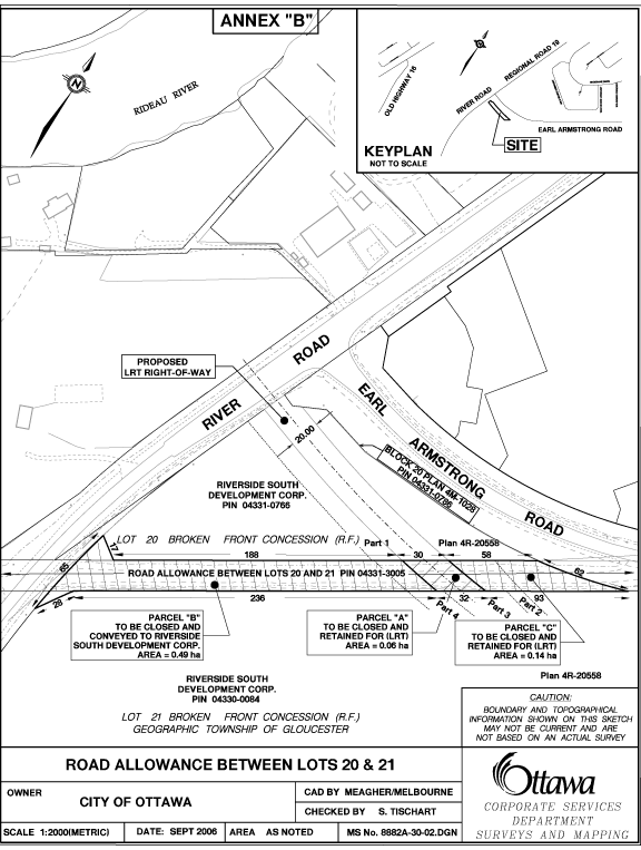
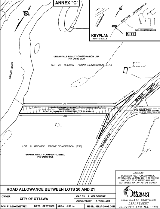
Continuing development in the South Urban Community is having an impact on surrounding roadway systems. In particular, the development of Riverside South has necessitated the upgrading of Earl Armstrong Road to a two-lane, undivided arterial. In making these upgrades, it was necessary for Urbandale to relocate the intersection of Earl Armstrong Road with River Road. The relocation of this intersection was made necessary in order to align Earl Armstrong Road, with the future location of the Strandherd Bridge crossing at the Rideau River. This intersection has been relocated and dedicated to the City for several years.
In relocating the Earl Armstrong/River Road intersection, it was the intent of the parties that the no longer required portions of Earl Armstrong Road would be transferred to Urbandale, in exchange for the relocated roadway. As part of an agreement between the City and Urbandale, the City agreed to make application to close two sections of Earl Armstrong Road, with a view to transferring the sections to Urbandale. These sections of Earl Armstrong Road are shown hatched on the attached Annexes “B” and “C”.
DISCUSSION
While Urbandale has already transferred the realigned portion of Earl Armstrong Road to the City, the two sections of Earl Armstrong Road have not yet been transferred to Urbandale. These sections of Earl Armstrong Road are shown hatched on the attached Annexes “B” and “C”. The application to close these sections of Earl Armstrong Road has been conditionally approved by Planning and Growth Management Services.
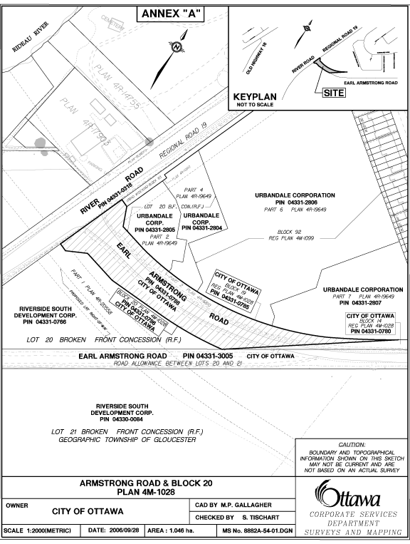
The realigned portion of Earl Armstrong Road that Urbandale has already transferred to the City contains an area of 1.046 ha and is shown hatched on the attached Annex “A” sketch. The two closed portions of Earl Armstrong Road that the City is to transfer to Urbandale are shown hatched as Parcel B, on Annex “B”, and all of the hatched area shown on Annex “C”. The two City-owned parcels have a combined area of 1.07 ha.
Parcel B on Annex “B”, is to be transferred to Riverside South Development Corporation. All of the hatched area shown on Annex “C” is to be transferred to Urbandale Realty Corporation.
Recent appraisals indicate the total market value of the City’s two parcels to be $398,320.00, which is offset by the value of the lands previously dedicated to the City by Urbandale.
The City’s two parcels of land are situated in areas zoned Fg – Future Growth. Upon the closure of these two sections of road allowance, the land is to be conveyed to Urbandale and developed in accordance with the Riverside South Community Design Plan.
The agreement between the City
and Urbandale is considered fair and reasonable, and is recommended for
acceptance.
CONSULTATION
In accordance with policies approved by City Council on 14 November 2001, the availability of the property was circulated to all client City Departments, including the Housing Branch, Public Works and Services and Planning and Growth Management Services, to determine if the parcel should be retained for a City mandated program. The Environmental Management Group of the Planning and Growth Management Services Department was consulted with respect to the Greenspace Master Plan and their comments are indicated under the Environmental Implications section of this report. Neither the Housing Branch nor any other City Department expressed interest in retaining the property.
The utility companies were also circulated and no requirements were indicated.
The following Advisory Committees have been circulated:
Local Architectural Conservation Advisory Committee
Ottawa Forests and Greenspace Advisory Committee
Environmental Advisory Committee
Parks and Recreation Advisory Committee
Roads and Cycling Advisory Committee
Rural Issues Advisory Committee
Arts, Heritage and Culture Advisory Committee
Pedestrian and Transit Advisory Committee
Circulation comments have not been received at the time of writing this report, however any objections to the disposal of this property received through the circulation process, will be reported to Corporate Services and Economic Development Committee when this report is considered.
The Ward Councillor has been made aware of the intent to dispose of the subject property through circulation.
ENVIRONMENTAL IMPLICATIONS
The road allowance being disposed of extends to the shoreline of the
Rideau and includes the shoreline and bank areas. This area is designated as Major Open Space in the Official Plan
and any development in the area will have to reflect this designation, as well
as policies in the Official Plan related to protection of river valleys and
setbacks from top of bank.
In this case, the Riverside South Community Design Plan for the area
reflects these designations.
Considerations related to the open space area and required development
setbacks, will be finalized during the development design and review
process. Subject to adherence to the
Official Plan and Community Design Plan for the area, there are no environmental
implications for the disposal of the road allowance.
The Official Plan policy directs that the City make land available for affordable housing and give priority for the sale or lease of surplus City-owned property for this purpose.
The Housing First Policy, approved by Council on 13 July 2005, establishes priority consideration to the Housing Branch, in the identification of potentially surplus City-owned property, to be used in achieving the City’s affordable housing program targets. The policy also requires that the Official Plan target of 25% affordable housing, be met on any City-owned property, sold for residential development. Where viable, residential properties are disposed of without a condition requiring an affordable housing component, 25% of the proceeds from the sale are to be credited to a housing fund, to be used for the development of affordable housing elsewhere in the City.
The subject properties are non-viable parcels and therefore do not meet the affordable housing criteria outlined in the Housing First Policy.
FINANCIAL IMPLICATIONS
There are no financial implications as a result of the recommendations within this report.
SUPPORTING DOCUMENTATION
Attached as Annex “A”, is a sketch showing the former Urbandale property.
Attached as Annexes “B” and “C”, are sketches showing the City’s two properties.
DISPOSITION
Following Council’s approval, Real Property Asset Management and Legal Services Branches will finalize the transaction.