1. A STRATEGY TO RECOGNIZE AND PROTECT THE PUBLIC WATERFRONT
RECREATIONAL ACCESS FUNCTION OF SELECTED ROAD ALLOWANCES ON THE OTTAWA AND
RIDEAU RIVERS
STRATÉGIE VISANT À
RECONNAÎTRE ET À PROTÉGER L’UTILISATION DE CERTAINES EMPRISES ROUTIÈRES EN
TANT QUE POINTS D’ACCÈS RIVERAINS PUBLICS POUR DES ACTIVITÉS RÉCRÉATIVES SUR
LES RIVIÈRES RIDEAU ET DES OUTAOUAIS
|
HEALTH, RECREATION
AND SOCIAL SERVICES COMMITTEE RECOMMENDATIONS
That
Council approve:
1.
The strategy (as included in
Appendix A) to recognize and protect the public waterfront recreational access
function of selected road allowances on the Ottawa and Rideau Rivers;
2.
The development of a Waterfront
Access Point sub-zoning to recognize the distinct characteristics of municipal
waterfront access points; and
3.
The implementation of the road
allowance conversion and zoning process for the first priority road allowances
(as identified in Appendix B) where there is significant community support to
proceed.
AGRICULTURE AND
RURAL AFFAIRS COMMITTEE RECOMMENDATIONS AS AMENDED
That
Council approve:
1.
The strategy (as included in
Appendix A) to recognize and protect the public waterfront recreational access
function of selected road allowances on the Ottawa and Rideau Rivers;
2.
The development of a Waterfront
Access Point sub-zoning to recognize the distinct characteristics of municipal
waterfront access points;
3.
The implementation of the road
allowance conversion and zoning process for the first priority road allowances
(as identified in Appendix B) where there is significant community support to
proceed; and
4. WHEREAS the Rural
Issues Advisory Committee has heard concerns, as part of its consultation with
staff around the development of this report, from residents of West Carleton
and formerly expressed concerns that the City will be proceeding with the
rezoning of road allowances with river access in West Carleton;
AND
WHEREAS the implementation of the Village Plan for Constance Bay is not
complete and a significant number of road allowances with river access in West
Carleton are in Constance Bay;
AND
WHEREAS residents of Constance Bay, with the assistance of their Councillor,
have formed a Constance Bay Beach Committee to further examine the issue;
AND
WHEREAS the staff report does not include any proposed conversion in West
Carleton and the report clearly indicates that “no work on the conversion of
these properties will be undertaken until a consensus has been achieved by the
residents of the Ward on how to best recognize and protect these properties”;
AND
WHEREAS Committee and Council must consider each request for rezoning of a road
allowance individually in accordance with the Ontario Planning Act;
THEREFORE
BE IT RESOLVED THAT the Agriculture and Rural Affairs Committee recommend to
Council that the report be amended to include a fourth recommendation as
follows:
That
City staff support the work of the Constance Bay Beach committee and, as staff
will be bringing forward reports in the future related to consideration by
Committee and Council of the conversion of additional road allowances with
river access, that no road allowances in West Carleton be considered for
conversion until requested by the Councillor for that Ward.
RecommandationS du comitÉ DE
LA SANTÉ, DES LOISIRS ET DES SERVICES SOCIAUX
Que le Conseil
municipal approuve :
1. La
stratégie (jointe à l’annexe A) visant à reconnaître et à protéger
l’utilisation de certaines emprises routières en tant que points d’accès
riverains publics pour des activités récréatives sur les rivières Rideau et des
Outaouais;
2.
L’établissement d’une
sous-zone « point d’accès au secteur riverain » visant à reconnaître
les caractéristiques distinctes des points d’accès au secteur riverain
municipal; et
3.
La mise en œuvre du processus
de conversion et de zonage des emprises routières pour ce qui concerne les
emprises routières de première priorité (définies à l’annexe B) lorsque ce
processus bénéficie d’un appui important de la part de la collectivité.
RecommandationS modifiÉes du comitÉ DE
L’AGRICULTURE ET DES QUESTIONS RURALES
Que le Conseil
municipal approuve :
1. La
stratégie (jointe à l’annexe A) visant à reconnaître et à protéger
l’utilisation de certaines emprises routières en tant que points d’accès
riverains publics pour des activités récréatives sur les rivières Rideau et des
Outaouais;
2.
L’établissement d’une
sous-zone « point d’accès au secteur riverain » visant à reconnaître
les caractéristiques distinctes des points d’accès au secteur riverain
municipal;
3.
La mise en œuvre du
processus de conversion et de zonage des emprises routières pour ce qui
concerne les emprises routières de première priorité (définies à l’annexe B)
lorsque ce processus bénéficie d’un appui important de la part de la
collectivité; et
4. ATTENDU QUE le Comité
consultatif sur les questions rurales a eu connaissance, lors de sa
consultation menée auprès du personnel pour l’élaboration du présent rapport,
de préoccupations exprimées par les résidents de West Carleton et d’anciennes
préoccupations liées au fait que la Ville attribuera un nouveau zonage aux
emprises donnant accès à la rivière à West Carleton;
ATTENDU QUE la mise en œuvre du plan du
village de Constance Bay n’est pas terminée et qu’un nombre important
d’emprises donnant accès à la rivière à West Carleton se trouvent à Constance
Bay;
ATTENDU
QUE les résidents de Constance Bay, avec l’aide de leur conseiller, ont créé le
Comité de la plage de Constance Bay, chargé d’examiner plus en détail cette
question;
ATTENDU QUE le rapport du personnel ne
contient aucune proposition de transformation à West Carleton et que ce rapport
indique clairement qu’ « aucuns travaux de transformation de ces
propriétés ne seront entrepris avant qu’un consensus ne soit passé chez les
résidents du quartier quant à la façon de reconnaître et de protéger le mieux
possible ces propriétés »;
ATTENDU QUE le Comité et le Conseil doivent
examiner individuellement chaque demande d’attribution de nouveau zonage d’une
emprise, conformément à la Loi sur l’aménagement du territoire de l’Ontario;
PAR CONSÉQUENT, IL EST RÉSOLU QUE le Comité de l'agriculture et des
questions rurales recommande au Conseil de faire modifier le rapport de manière
à ce qu’il contienne la quatrième recommandation suivante :
Que
le personnel de la Ville soutienne le travail du Comité de la plage de
Constance Bay et, lorsque le personnel présentera des rapports portant sur
l’examen par le Comité et le Conseil de la transformation d’autres emprises
donnant accès à la rivière, qu’aucune transformation d’emprise de West Carleton
ne soit examinée sans que le conseiller du quartier en ait fait la demande.
Documentation
1.
Deputy
City Manager, Community and Protective Services report dated 14 September 2006
(ACS2006-CPS-PAR-0011).
2. Extract of Draft Minutes 40, Health,
Recreation and Social Services Committee meeting of September 21, 2006.
3. Extract of Draft Minutes 33,
Agriculture and Rural Affairs Committee meeting of September 28, 2006.
Report
to/Rapport au:
Health, Recreation and Social Services Committee
Comité de la santé, des loisirs et
des services sociaux
and /
et
Agriculture
& Rural Affairs Committee
Comité de l'agriculture et des
questions rurales
and Council / et au Conseil
14 September 2006 /
le 14 septembre 2006
Submitted by/Soumis par : Steve Kanellakos,
Deputy City Manager/Directeur municipal adjoint,
Community and Protective Services/Services communautaires et de
protection
Contact
Person/Personne ressource : Aaron Burry, Director
Parks and Recreation/Parcs et Loisir
(613) 580-2424 x, Aaron.burry@ottawa.ca
Contact Person/Personne ressource :
(613) 580-2424 x 23666,
|
|
Ref N°: ACS2006-CPS-PAR-0011
|
|
SUBJECT:
|
A STRATEGY TO RECOGNIZE AND PROTECT
THE PUBLIC WATERFRONT RECREATIONAL ACCESS FUNCTION OF SELECTED ROAD
ALLOWANCES ON THE OTTAWA AND RIDEAU RIVERS
|
|
|
|
|
OBJET :
|
STRATÉGIE VISANT À RECONNAÎTRE ET À PROTÉGER l’utilisation de certaines emprises routières en tant que points d’accès
riverains publics pour des activités récréatives sur les rivières rideau et
des outaouais
|
REPORT RECOMMENDATIONS
That the Health, Recreation and Social
Services Committee and the Agriculture and Rural Affairs Committee recommend
Council approve:
1. The strategy (as
included in Appendix A) to recognize and protect the public waterfront
recreational access function of selected road allowances on the Ottawa and
Rideau Rivers.
2. The development of a
Waterfront Access Point sub-zoning to recognize the distinct characteristics of
municipal waterfront access points.
3. The
implementation of the road allowance conversion and zoning process for the
first priority road allowances (as identified in Appendix B) where there is
significant community support to proceed.
RECOMMANDATIONS DU
RAPPORT
Que le Comité de la santé,
des loisirs et des services sociaux et le Comité de
l'agriculture et des questions rurales recommandent au Conseil d’approuver :
1.
La stratégie (jointe à l’annexe A)
visant à reconnaître et à protéger l’utilisation de certaines emprises
routières en tant que points d’accès riverains publics pour des activités
récréatives sur les rivières Rideau et des Outaouais.
2.
L’établissement d’une
sous-zone « point d’accès au secteur riverain » visant à reconnaître
les caractéristiques distinctes des points d’accès au secteur riverain
municipal.
3.
La mise en œuvre du
processus de conversion et de zonage des emprises routières pour ce qui
concerne les emprises routières de première priorité (définies à l’annexe B)
lorsque ce processus bénéficie d’un appui important de la part de la
collectivité.
EXECUTIVE SUMMARY
Public access to the shorelines of the
Ottawa and Rideau rivers is an important contributor to the quality of life for
City of Ottawa residents. This has been
recognized in the City’s Official Plan where it states “The City will ensure
that the shoreline of the Ottawa River, Rideau River and Canal, and other
shorelines remain accessible…” and recommends that “the City, will use such
measures as public acquisition, conservation easements or other appropriate
means to secure public access to the shorelines”. Shoreline property is a finite resource and the opportunities to
acquire it for public uses are limited.
This report presents an opportunity to recognize and protect sixty
existing public access opportunities on the Ottawa and Rideau Rivers for
minimal expense and effort.
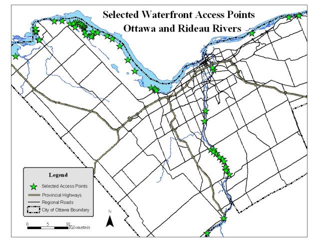
In 2005, the Ottawa and Rideau
Rivers Waterfront Recreation Access Study inventoried 326 publicly accessible
waterfront properties on the Ottawa and Rideau Rivers. One hundred and ninety-two (192) of these
properties are road allowances or rights-of-way providing either existing or
potential public access to the rivers.
Through the application of defined criteria it was determined that 60 of
these allowances offer significant existing or potential public access
opportunities.
The road allowances generally
provide informal access for recreational activities such as fishing, canoeing
and swimming and offer a minimum of amenities.
At the present time however, the allowances are classified as roads and
their recreational function is not formally recognized.
Over time it has been shown that
some of these properties acquire functions that are incompatible with public
use including private laneways, residential parking areas, storage areas or
other forms of encroachment.
Historically, some allowances have also been closed and sold to adjacent
property owners resulting in the permanent loss of public access to the
shoreline.
As a means of both recognizing
and protecting the recreational function of the waterfront portion of the
selected road allowances, Parks and Recreation is proposing to convert the existing
road allowance designation of these properties to an "Open Space"
zoning as outlined in this report.
RÉSUMÉ
L’accès public aux rives des
rivières Rideau et des Outaouais contribue grandement à la qualité de vie des
résidents d’Ottawa, ce que reconnaît le Plan officiel de la Ville lorsqu’il
mentionne que « [l]a Ville s’assurera que les berges de la rivière des
Outaouais, de la rivière et du canal Rideau ainsi que les autres berges
demeurent accessibles […] » et recommande que « la Ville
[ prenne ] d’autres mesures, comme l’acquisition, la création d’une
servitude de conservation, l’adoption de mesures pertinentes pour assurer
l’accès public aux berges ». Les rives sont une ressource finie et les
possibilités d’en acquérir pour que le public les utilise sont peu nombreuses.
Ce rapport présente une occasion de reconnaître et de protéger, à peu de frais
et sans beaucoup d’effort, soixante possibilités d’accès public existant sur
les rivières Rideau et des Outaouais.
En 2005, l’étude sur l’accès aux installations
récréatives riveraines sur les rivières Rideau et des Outaouais a recensé
326 propriétés riveraines où le public peut accéder aux rivières Rideau et
des Outaouais. Cent quatre-vingt-douze (192) de ces propriétés sont des
emprises routières ou des droits de passage qui donnent, ou pourraient donner,
au public accès à ces rivières. Des critères ont été définis, dont
l’application a permis d’établir que 60 de ces emprises offrent au public une
possibilité, réelle ou éventuelle, importante d’accéder aux rives.
Les emprises routières fournissent en général
un accès officieux pour des activités récréatives telles que la pêche, le
canotage et la baignade, et offrent un minimum de commodités. À l’heure
actuelle cependant, les emprises sont classées parmi les routes et leur
fonction récréative n’est pas officiellement reconnue.
Le passage du temps a montré que certaines de
ces propriétés acquièrent des fonctions incompatibles avec l’utilisation par le
public, lorsqu’elles deviennent, par exemple, des allées privées, des zones de
stationnement résidentiel, des aires d’entreposage ou d’autres formes
d’empiètement. Par le passé, certaines emprises ont également été fermées et
vendues à des propriétaires fonciers avoisinants, si bien que le public a perdu
en permanence des accès aux berges.
Pour reconnaître et protéger la fonction
récréative de la portion riveraine des emprises routières choisies, Parcs et
loisirs propose de modifier la désignation de ces propriétés, à l’heure
actuelle considérées comme des routes, et de les zoner « espaces
ouverts », comme l’explique le présent rapport.
BACKGROUND
In
2005, the Ottawa and Rideau Rivers Waterfront Recreation Access Study
inventoried three hundred and twenty-six (326) publicly accessible waterfront
properties on the Ottawa and Rideau Rivers.
These included municipal, provincial and federal parks, conservation
lands and undeveloped properties as well as privately operated facilities (e.g.
Marinas) offering public access. One
hundred and ninety-two (192) of these properties are road allowances or
rights-of-way (from 2 metres to 20 metres wide) providing either existing or
potential public access to the rivers.
Through the application of defined criteria (see Table 1 in Section 2.0
in Appendix A) it was established that there are sixty (60) of these allowances
that offer significant (existing or potential) public access
opportunities. Forty (40) of the
allowances are located on the Ottawa River with the remaining twenty (20) on
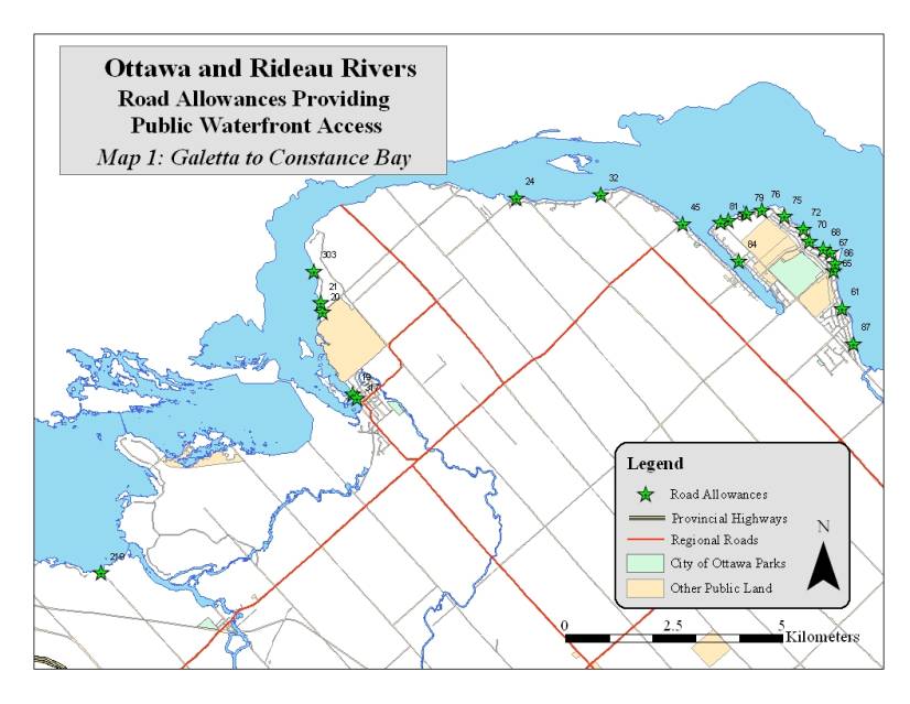
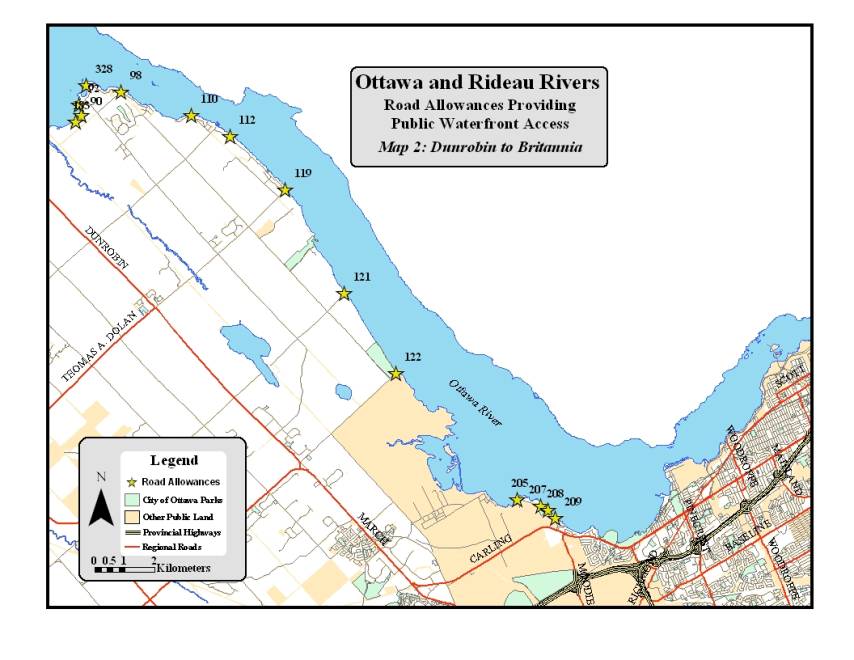
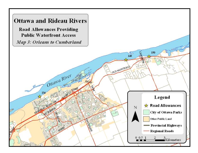
the Rideau River (see the map on page 4 for locations of selected allowances).
The
road allowances generally provide informal access for recreational activities
such as fishing, canoeing and swimming and offer a minimum of amenities. At the present time however, the allowances
are classified as roads and their recreational function is not formally
recognized. Over time it has been shown
that some of these properties acquire functions that are incompatible with
public use including use as private laneways or parking areas for adjacent
residences, the storage of materials, or other forms of encroachment. Historically, some allowances have also been
closed and sold to adjacent property owners resulting in the permanent loss of
public access to the shoreline.
|
|
|
|
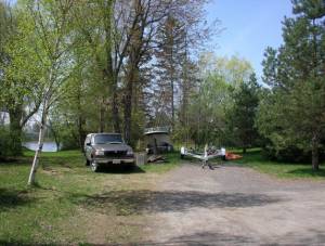
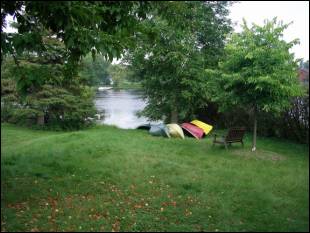
Potential public access point with encroachments
|
Established community access point
|
|
ANALYSIS
As
a means of both recognizing and protecting the recreational function of the
waterfront portion of the selected road allowances, Parks and Recreation is
proposing to convert the existing road allowance designation of these
properties to an "Open Space" zoning. This is a two-step process with specific legal requirements
(defined under the Provincial Planning Act) including public notification and approval
by Council for each step. Parks and
Recreation is also recommending that a waterfront access point sub-zoning be
established (in consultation with the affected communities) to define permitted
uses, setbacks and other measures to support the public access function. The benefits of these actions would be a
shift in orientation for these properties from a transportation role to a
public access role. Once this process
is concluded, the properties would be designated and managed as public
waterfront access points with a level of service to be determined in
partnership with the communities where they are located. For most of the sites, the intention will be
to provide basic public access with limited or no amenities. While it is not anticipated that, for the
vast majority of the properties, there would be a significant change in how
they are presently being used by the public, it would recognize public access
as the primary function and help to ensure that where public access is
presently being denied, that the properties are made accessible.
Parks
and Recreation recognizes that full implementation of the proposed strategy is
a long term objective, thus the Branch is proposing a "phased"
approach to its implementation.
The
first step, following Council's approval of the strategy to recognize and
protect the access of selected road allowances, will be for Planning and Growth
Management to create a Waterfront Access Point sub-zoning of the Open Space
zoning.
The
second step is the conversion of the existing road allowance designation to the
Waterfront Access Point sub-zoning of the Open Space zone for the selected
sixty road allowances. As a means of
facilitating this action, the allowances have been classified into three
priorities for implementation. This
report recommends the implementation of the road allowance conversion and
zoning process for the first priority sites only. Parks and Recreation will only seek Council approval for priority
2 sites if there is a consensus to move forward with the conversion process in
West Carleton Ward. Priority 3 road
allowances require the resolution of ownership or encroachment issues before
approval is to be sought.
Priority
1:
The
conversion of twenty-three (23) road allowances on the Ottawa and Rideau Rivers
(listed in Appendix B) for which there is an established public access function
and where public consultation has shown that there is general support for the
re-zoning within the community.
Priority
2:
The
possible conversion and zoning of thirty-one (31) allowances in West Carleton
Ward, of which the majority have an established public access function but
where consensus on how best to recognize this function has not been achieved in
the affected communities. No work on
the conversion of these properties will be undertaken until a consensus has
been achieved by the residents of the Ward on how to best recognize and protect
these properties.
Priority
3:
The
conversion of six (6) road allowances (listed in Appendix C) with a potential
public access function that requires a resolution of issues such as
encroachments and possibly further analysis to determine their future public
access role.
RURAL IMPLICATIONS
Fifty-one
of the sixty selected allowances are located in the rural area of which 15 are
recommended for conversion in this report (identified as Priority 1 in Appendix
B). The primary beneficiaries of this
strategy would be rural residents for whom public access to the Rideau and
Ottawa Rivers would be recognized and protected.
CONSULTATION
Three
public consultations were held to present the proposed strategy and to receive
comments.
November
21, 2005: Crystal Bay Community
Centre. Thirty members of the community
and Councillor Alex Cullen participated.
January
18, 2006: Manotick Public School
Gymnasium. Thirty-five members of the
community and Councillor Glenn Brooks participated.
January
19, 2006: Kinburn Client Service
Centre. Eighty-six members of the
community and Councillor Eli El-Chantiry participated.
Summaries
of the public comments are provided in Appendix A.
Planning
and Growth Management and Corporate Services (Legal Services Branch) were both
consulted in the development of this strategy.
The
conversion of the road allowance designation to an Open Space zoning requires
both public notification and consideration of input from the public.
An
Executive Summary of the Report to Committee was circulated to four City of
Ottawa Advisory Committees and presentations were made and comments received
from three of those Committees (Environmental Advisory Committtee, Roads and
Cycling Advisory Committee, Parks and Recreation Advisory Committee and Rural
Issues Advisory Committtee). Motions
were prepared and submitted by the Environmental Advisory Committee and the
Rural Issues Advisory Committes and are as follows:
Environmental Advisory Committee
The
Environmental Advisory Committee supports a City Strategy to own, recognize,
protect, and manage the 192-identified, publicly accessible waterfront
properties for the dual purposes
of
1. public access to waterways for defined
recreational use
2. ecological protection of these river
riparian areas on the Ottawa and Rideau Rivers.
EAC doesn't
support the selling of these public lands to private owners, and if so, that
there be full public review including input from EAC.
The EAC
recommends that the proposed Strategy include the following components:
1. Stewardship
Agreements - With each road allowance being designated "Open
Space" rezoning that there be a collaborative "Stewardship
Agreement" signed between the City and the local community-neighbouring
landowners. This Agreement would
commit parties to the protection and nature of recreation with shared operating
roles and ongoing management of this public property. The Agreement can be re-opened by either party if future problems
should arise.
2. Operating Budget - The City designate a small amount of funds
for appropriate signage and management of properties, if required.
3. Defining
a healthy balance between recreational use and protection of riparian area
within property and water quality. For each River access, the City be
responsible for establishing a balance between defined recreational use and the
protection and enhancement of riparian area and water quality within the
"Open Space" section of riverbank.
The relevant Conservation Authority and Parks Canada (in case of Ottawa
River) review and support of the "Stewardship Agreement", where this
balance will be defined. This balance to
address existence of riparian vegetation, 30 metre set-back for any buildings
and parking areas, collection of garbage, washroom facilities, use of high
speed motor boats, noise, nature of road access, etc.
4. Monitoring Reports - Three years following
conversion, zoning of road allowances, and signing of "Stewardship
Agreements", that City monitor and report on the accumulative impacts of
riverbank uses on the health of that section of River watershed and in meeting
recreational objectives. EAC would be
interested in reviewing these riverbank monitoring reports.
Rural Issues Advisory Committee
BE IT RESOLVED that road allowances
in West Carleton Ward be left in the community domain as they are now, and;
That rural road allowances be
forwarded to the Agriculture and Rural Affairs Committee (ARAC), not the
Health, Recreation and Social Services Committee, and;
That the Rural Issues Advisory
Committee (RIAC) refuse to endorse the presentation as submitted, and;
That the RIAC recommend to the ARAC that City staff be directed to
permanently remove from its work plan, any effort whatsoever to change the
status of waterfront access point abutting the Ottawa River in West Carleton
Ward.
Roads and Cycling Advisory Committee
A presentation was made to the Roads and Cycling
Advisory Committee and verbal comments were received. The Committee was
supportive of the intentions of the report.
Parks and Recreation Advisory Committee
The
Committee received the report without providing comment.
Presentation to Rideau Ward Council, North Gower Client Service Centre,
July 30, 2006
While
not a formal public advisory committee the Rideau Council provides public input
to the councillor for Rideau Ward on issues and projects affecting this ward.
An
Executive Summary of the Report to Committee was distributed in advance of the
meeting and a formal presentation was made.
The council supported the Strategy and recommended that it apply to all
of the selected waterfront road allowances in Rideau Ward.
Presentation to Constance Bay Community
Association, Contance Bay Community Centre, August 17, 2006
Staff were invited to the Constance Bay
Community Association meeting to address a series of questions raised by the
Association and to clarify the intent of the report.
FINANCIAL IMPLICATIONS
Planning
and Growth Management will be responsible for the establishment of a Waterfront
Access Point sub-zoning and for the road allowance conversion and zoning
process.
An
existing Parks and Recreation Capital Budget will be used to fund signage for
re-zoned sites.
SUPPORTING DOCUMENTATION
Appendix
A: A Strategy To Recognize And Protect
The Public Waterfront Recreational Access Function Of Selected Road Allowances
On The Ottawa And Rideau Rivers
Appendix
B: Priority 1 Ottawa and Rideau Rivers Road Allowances (Recommended for
Conversion)
Appendix
C: Priority 2 and 3 Ottawa and Rideau Rivers Road Allowances (for Future
Consideration)
DISPOSITION
Community and Protective Services, Planning and Growth
Management and Corporate Services are to implement the direction of the
Committees and Council.
APPENDIX A
A Strategy to Recognize And Protect Public
Waterfront Recreational Access for Selected Road Allowances on the Ottawa and
Rideau Rivers
1.0 Introduction
Public
access to waterfront is an important contributor to the quality of life of City
of Ottawa residents. This has been recognized in the City’s Official Plan where
it states “The City will ensure that the shoreline of the Ottawa River, Rideau
River and Canal, and other shorelines remain accessible…” and recommends that
“the City, will use such measures as public acquisition, conservation easements
or other appropriate means to secure public access to the shorelines”.
There are many different facets to public waterfront access. Within
the urban area of the City of Ottawa the City’s public beaches and waterfront
parks and the National Capital Commission’s extensive network of public lands
offer easy access to the shorelines of the Ottawa and Rideau Rivers and the
Rideau Canal. On the edges or outside
of the urban area however, there are other lower profile properties that offer
important public waterfront access opportunities yet whose role is not formally
recognized. Shoreline property is a finite resource and the opportunities to
acquire it for public use are limited and when available, expensive. In 2005,
the Ottawa and Rideau Rivers Waterfront Recreation Access Study prepared for
City of Ottawa Parks and Recreation Department identified sixty waterfront road
allowances that either already support public recreational access to the Ottawa
and Rideau Rivers or could support access in future. This document outlines a
strategy to recognize and safeguard the public recreational access role of
these road allowances.
2.0 Context
The
Ottawa and Rideau Rivers Waterfront Recreation Access Study (2005) inventoried
three hundred and twenty-six (326) publicly accessible waterfront properties on
the Ottawa and Rideau Rivers. One hundred and ninety-two (192) of these
properties are road allowances or rights-of-way (from 2 metres to 20 metres
wide) providing either existing or potential public access to the rivers.
Through the application of the criteria listed in Table 1 it was established that
there are sixty (60) allowances with a significant (existing or potential)
recreational function.
Table
1
Criteria used to identify
road allowances with a significant existing or potential recreational function
¨
Minimum width of 20
metres
and a maximum distance of 150 meters from the shoreline to an intersection with
a public roadway
¨
Either a minimum of
400 square metres of the road allowance available for public access or the road
allowance provides access to adjacent public waterfront property
¨
A shoreline that is
amenable to waterfront recreational activities (boat launching, swimming,
fishing etc.)
The following table gives
a breakdown of the location of the sixty allowances:
Table 2
|
River
|
Ward
|
Allowances with Rec. Potential
|
|
Ottawa
|
West Carleton
|
31
|
|
Ottawa
|
Kanata
|
2
|
|
Ottawa
|
Bay
|
4
|
|
Ottawa
|
Orleans
|
1
|
|
Ottawa
|
Cumberland
|
2
|
|
Rideau
|
Capital
|
2
|
|
Rideau
|
Gloucester-Southgate
|
1
|
|
Rideau
|
Bell-South Nepean
|
1
|
|
Rideau
|
Osgoode
|
4
|
|
Rideau
|
Rideau
|
12
|
|
|
|
Total: 60
|
Fourteen of the
allowances are in the community of Constance Bay, four in the community of
Crystal Bay and eight others are concentrated in an eight kilometre section of
the Rideau River near Manotick. Maps showing the location of each of the
allowances are provided in section 7.0.
3.0 Existing or Potential Function
In
most instances the existing or potential function of the allowances is to
provide informal access to the shoreline of the rivers for residents of the
immediate neighbourhood. In a limited number of cases they service the needs of
the larger community through the provision of a boat ramp or other basic
services. Many of the allowances offer a gently sloping shoreline that allows
the launching of small watercraft such as canoes or kayaks and in some
instances boats on trailers. In certain locations the allowances provide an
informal park function and are used for picnicking and swimming whereas, in
other instances they provide access to publicly owned shoreline properties that
are adjacent to the allowances.
The
potential of these properties is limited by a number of factors. All of the
selected allowances are 20 metres wide and the properties are generally quite
small, ranging in size from less than 1000 square metres to a maximum of just
over 5000 square metres with the majority being between 1000 and 2000 square
metres. In many instances there are developed residential properties on both
sides of the allowance and in certain locations the allowance is used to
provide motorized vehicle access to these properties. There are generally no amenities
other than the odd picnic table or garbage can and the City of Ottawa provides
little or no maintenance. In some instances residents of the neighbourhood look
after a site while at others the site is in a natural state and un-maintained.
There are issues at certain sites including encroachments and problems with
trash.
4.0 Issues
There are a number of
issues associated with road allowances that provide public waterfront access:
¨
Road allowances that
do not have a transportation function and which are not actively used by the
public tend, over time, to acquire other functions, some of which are
incompatible with public use (e.g. private laneway or parking, storage of
materials, private docks)
¨
The recreational
activity taking place on these sites is not legally recognized
¨
No modifications to
the sites are legally permitted
¨
The public access
potential of these properties is sometimes not being achieved due to a number
of factors (e.g. lack of awareness that they are public property, private use,
conflicts with neighbouring landowners)
¨
Over time unused
allowances are vulnerable to being sold
¨
The City must
justify ownership of an unused road allowance when a request to purchase is
made
¨
The City has limited
ability to manage certain activities on these properties (e.g. motorized
vehicle use including snowmobiling and all-terrain vehicles)
¨
The majority of the
sites are not regularly maintained and there are some where problems such as
dumping occur
Residents
and councillors have voiced a concern that, while these properties are often
valued public resources, the community has little say in how the properties are
managed by the City. The City with minimal public consultation can sell an
allowance. Adjacent property owners can also apply to use the allowances as a
means to access their property. Encroachments are not uncommon and the
development or redevelopment of adjacent properties can diminish the
recreational potential through the removal of vegetation and/or the
construction of large homes whose impact extends right up to the edge of the
property line.
In
2003, based on the concerns of residents in the Crystal Bay community, Bay Ward
councillor Alex Cullen brought forward a motion:
That staff prepare a report for Committee on the re-designation of the
road allowance accesses from Grandview Road and Nesbitt Street to the Ottawa
River as parkland.
The
intent of this motion was to establish a recreational vocation to replace the
existing transportation role of the road allowances. The strategy being proposed
in this document will address the intent of the motion brought forward by
Councillor Cullen however, the issue has been examined in the larger context of
the sixty road allowances (including those on Grandview Road and Nesbitt
Street) on the Ottawa and Rideau Rivers that were identified in the Ottawa and
Rideau Rivers Waterfront Recreation Access Study as having a significant
(existing or potential) recreational function.
The goal of this strategy
is to establish and implement a means to recognize the public waterfront access
role of selected road allowances.
5.0 Methodology
The
methodology employed to recognize the recreational function of road allowances
that provide waterfront access is as follows:
1. Identify the road allowances that either provide
public access to the Ottawa or Rideau Rivers for recreational activities or
offer the potential to provide public access in the future;
2. Evaluate alternative means to recognize the
recreational function of the selected properties and identify the most appropriate
approach;
3. Validate the selection of the properties and the
means by which they will be recognized through public consultation;
4. Seek approval of the strategy by the Agriculture
and Rural Affairs Committee (ARAC) and the Health, Recreation and Social
Services Committee (HRSS) and City Council;
5. Implement the strategy.
6.0 Review Process
The
inventory of public waterfront properties that was completed as part of the
Ottawa And Rideau Rivers Waterfront Recreation Access Study resulted in the
identification of one hundred and ninety-two road (192) allowances and
rights-of-way. An initial screening
of these properties documented approximately eighty (80) allowances with
recreational potential. All of the sites were then visited in the fall of 2004
in order to validate the initial assessment and determine each site’s primary
advantages and disadvantages. Ultimately, sixty road allowances were identified
as having a significant existing or potential recreational function.
For
each of these sites the following information was collected:
¨
A description of the
human context including, the existing facilities and the use being made of
them, neighbouring land uses, encroachments, proximity to other public
waterfront access points;
¨
A description of the
natural context including topography, vegetation, character of the shoreline,
presence of unique natural features or habitats;
¨
A summary of the
site’s advantages and constraints;
¨
An estimation of the potential of
the site to support future activities including boating, swimming and fishing;
¨
Digital photos of
the site’s features
Data
sheets listing all of this information have been prepared for each of the sites
and are available in a separate document. In addition, all of the sites were
mapped using ArcView GIS and an associated database with assessed attributes
for each site was created. The attributes included: large boat access, small
boat access, parking capacity, beach potential, emergency access and
conservation values.
7.0 Options For Recognizing The Public
Waterfront Access Function of Selected Road Allowances
The
objective of this strategy is to recognize and protect the recreational
function of road allowances that provide public waterfront access. A road
allowance is land that has been set aside either at the time of the initial
land survey or during the land development process for transportation purposes.
All of the road allowances identified in this strategy are public property
owned by the City of Ottawa. Active road allowances are either “open” or
“unopened” and the difference is generally reflected by the standard of
construction and level of maintenance provided.
Road allowances cannot be zoned and, while they are often used to delimit a
zoning designation, unless a zoning designation boundary exists, zoning flows
over an allowance to the adjacent property.
There
are essentially three designation options that could support the public
waterfront access function: The first option is for these properties to remain
as road allowances; the second is to close the road allowance
and re-zone the property (where required) as Open Space. The third option
builds on option two with the creation of a Waterfront Access Point sub-zone of
the Open Space zoning for the waterfront road allowances.
Option
1: Maintain the property as a road allowance
The
advantages of leaving the properties as road allowances are:
Ø
From a legal
standpoint a road allowance is a solid land use definition that can easily be
defended in court if there are issues of illegal access lanes or encroachments;
Ø The City can limit the creation of private
laneways and private accesses on the portions of road allowances that provide
waterfront access as long as there are alternative access routes to private
properties;
Ø
The City can allow
the portion of the road allowance that is being used for recreation purposes to
be operated as an informal public access point without the requirement to zone
the land as such.
The limitations of the status quo
are:
Ø
A road allowance can
be sold or re-zoned through a process that requires public notification and the
approval of council;
Ø There is no formal recognition of the public
recreation function of the property;
Ø
The City has fewer
options for managing public activities in unopened road allowances in comparison
to land zoned as Open Space;
Ø
At any time an
application can be made to the City to purchase an un-opened road allowance and
the City must consider this application triggering a process that involves an
internal review of the application and notification of nearby property owners.
Option 2: Convert the
waterfront portion of the selected road allowances to an Open Space zoning
The
advantages of this option are:
Ø
Provides a clear
recognition of the public role of these properties and some protection of their
function;
Ø
Eliminates the
possibility of the City granting permission for private vehicular access lanes
to adjacent properties;
Ø
Re-zoning would
generally be required for the sale of the property, a public process requiring
council approval.
Limitations of this option are:
Ø
Unless the property
is designated as a park the actual role of the property is not specifically
defined within the Open Space zoning (could be a utility corridor, hazard land
etc.)
Ø
Public waterfront
access function not specifically recognized
Option
3: Convert the waterfront portion of the selected road allowances to an Open
Space zoning with a Waterfront Access Point sub-zoning
The
advantages of this option are:
Ø
Defines and
recognizes the specific function of the property;
Ø Re-zoning would generally be required for the sale
of the property, a public process requiring council approval;
Ø Offers the possibility of establishing permitted
uses, setbacks and other measures to support the public access function.
Limitations of this
option are:
Ø Would only recognize and protect the public access
function of a limited number of waterfront road allowances.
The recommended strategy
is Option 3 as it provides the clearest recognition of the public waterfront
access function and offers the greatest protection of this activity while
providing enough latitude to support the range of interests of the different
communities.
8.0 Summary of Public Input
Three
public consultations were held to present the options for the recognition of
the public waterfront access function of the road allowances and to gather
comments on the options and the specific road allowances identified.
Ottawa
River Consultation, Crystal Bay November 21, 2005
This
consultation focused primarily on the four allowances on Grandview Avenue and
the one road allowance on Nesbitt Street. There was generally strong support
for the need for protection of public access function of these road allowances.
Some concerns expressed that the Open Space designation is too vague and open
to interpretation. There was greater support for a sub-zoning designation with
a clear definition of the function of the sites. Some concerns were expressed
that the change in zoning could result in increased use of the road allowances
and a loss of privacy for the adjacent landowner.
Rideau River Consultation January 18, 2006
The
majority of the participants at this consultation were residents of the area
along the Rideau River between Manotick and Kars. Most were supportive of the
re-zoning proposal although, similar to the residents of Crystal Bay, some
expressed concerns about the vagueness of the Open Space zoning and preferred
the Waterfront Access Point sub-zoning proposal. There were numerous questions
about specific road allowances, particularly those with encroachment issues.
Ottawa
River Consultation, West Carleton Ward January 19, 2006
The
consultation in West Carleton was quite different from the previous two. From a
number of the participants there was a negative, almost hostile reaction to the
proposals. Some of the arguments against the proposals were that the status quo
works fine, a concern that that the re-zoning would increase the visibility of
the sites and invite use by people who live outside of the community and, that
the proposals do not take into account the particular needs of the community.
On the other hand there was support for the proposals from a number of the
participants, particularly from residents who do not live on the water. There
was no clear consensus on the best approach to preserving the public access
points despite a general agreement that the road allowances play an important
role in providing local community access to the Ottawa River and that there are
numerous management issues related to their existence.
City of Ottawa Advisory Committees
Pedestrian and Transit Committee, City
Hall, June 15, 2006
An Executive Summary of
the Report to Committee was received without a presentation and no comments or
motions were provided
Environmental Advisory Committee, City
Hall, July 13, 2006
An
Executive Summary of the Report to Committee was distributed in advance of the
meeting and a formal presentation was made.
The Committee supported the Strategy and offered four motions to guide
the management of the waterfront access points. These motions emphasized the use of stewardship agreements
between the City and the local community group managing the access point, the
designation of an operating budget to manage the properties, defining a healthy
balance between public use and protection of the riparian area, and the
preparation of monitoring reports to measure the benefits and impacts of the
public activity.
Roads and Cycling Advisory Committee,
City Hall, July 17, 2006
An
Executive Summary of the Report to Committee was distributed in advance of the
meeting and a formal presentation was made.
Question and comments were received from the Committee but no formal
motions were offered.
Rural Issues Advisory Committee, Kinburn
Community Centre, July 18, 2006
An
Executive Summary of the Report to Committee was distributed in advance of the
meeting and a formal presentation was made.
A contingent of West Carleton residents also attended the meeting and
provided their input along with members of the Committee. The Committee refused to endorse the
presentation and recommended that the road allowances in West Carleton be left
in the public domain and that the City not consider changing the status of any
road allowances in West Carleton.
Presentation to Rideau
Ward Council, North Gower Client Service Centre, July 30, 2006
While
not a formal public advisory committee the Rideau Council provides public input
to the councillor for Rideau Ward on issues and projects affecting this ward.
An
Executive Summary of the Report to Committee was distributed in advance of the
meeting and a formal presentation was made.
The council supported the Strategy and recommended that it apply to all
of the selected waterfront road allowances in Rideau Ward.
Presentation to
Constance Bay Community Association, Constance Bay Community Centre, August 17,
2006
While
not a formal public advisory committee the Constance Bay Community Association
provides public input to the councillor for West Carleton Ward on issues and
projects affecting this ward.
Staff
clarified the intent of the report and addressed specific questions by the
Association.
9.0 Recommendations
Upon
completion of the public consultations it was recognized that while in the
longer term there would be merit in re-zoning all of the sixty road allowances
identified, in the shorter term a strategic approach based on a phased
implementation of the re-zoning would be most effective. Re-examining the
selected allowances resulted in the identification of three stages of
implementation.
- The first stage is
the conversion and zoning of twenty-three (23) road allowances on the
Ottawa and Rideau River for which there is an established public access
function and general support for zoning within the affected communities.
- The second stage
is the possible conversion and zoning of thirty-one (31) allowances in
West Carleton Ward of which the majority have an established public access
function but where consensus on how best to recognize this function has
not been achieved in the affected communities. No work on the conversion
of these properties will be undertaken until a consensus has been achieved
by the residents of the Ward as how to best recognize and protect these
properties
- The third stage is
the conversion and zoning of the six (6) road allowances that offer a
potential public access function but which require a resolution of issues
and possibly further analysis to determine their future public access
role.
9.1
Process
It
is proposed that for the closure and re-zoning of the road allowances the City
follow a three-step process.
Ø
The first step is to
establish the parameters for the proposed Waterfront Access Point sub-zoning in
consultation with Planning and Growth Management and the affected communities.
Ø
The second step
would be to convert the sections of the selected road allowances that have been
identified as providing a public waterfront access (based on the direction
provided in Section 9.0).
Ø
The third step would
be to zone the converted portion of the allowances with Waterfront Access Point
sub-zoning. The second and third steps require a specific legal process that
includes public notification and approval by City Council.
The
table on the next page summarizes the status of the sixty road allowances
examined in this report.
Table 3
|
River
|
Ward
|
Allowances with significant
recreational potential
|
Open
allowances
|
Unopened or Closed allowances
|
Allowances adjacent to, or providing access to
public land
|
Allowances with existing public use
|
Allowances with no existing public use
|
Boat Launch facilities (ramp)
Formal(F)
Informal(I)
|
|
Ottawa
|
West Carleton
|
31
|
12
|
19
|
11
|
22
|
9
|
2F,3I
|
|
Ottawa
|
Kanata
|
2
|
1
|
1
|
1
|
2
|
0
|
|
|
Ottawa
|
Bay
|
4
|
1
|
3
|
4
|
4
|
0
|
2I
|
|
Ottawa
|
Orleans
|
1
|
1
|
0
|
1
|
0
|
1
|
1F
|
|
Ottawa
|
Cumberland
|
2
|
2
|
0
|
2
|
1
|
1
|
1F
|
|
Rideau
|
Capital
|
2
|
2
|
0
|
2
|
2
|
0
|
|
|
Rideau
|
Gloucester/Southgate
|
1
|
1
|
0
|
0
|
0
|
1
|
|
|
Rideau
|
Bell-South Nepean
|
1
|
0
|
1
|
0
|
0
|
1
|
|
|
Rideau
|
Osgoode
|
4
|
2
|
2
|
0
|
0
|
1
|
|
|
Rideau
|
Rideau
|
12
|
9
|
3
|
3
|
9
|
3
|
1F, 1I
|
|
Totals
|
|
60
|
31
|
29
|
24
|
40
|
15
|
5 (F), 6(I)
|
10.0 Site Analysis Summary
The
next section is divided into two parts. The first part provides a table
summarizing the key attributes of the forty allowances located on the Ottawa
River and three maps showing their individual locations. The second part
provides similar information for the twenty allowances located on the Rideau
River.
Table 4: Ottawa River Road Allowances:
Summary Table and Location Maps
|
Site ID
|
Ward
|
Access Road
|
Area in square
metres
|
Open or
Unopened/Closed Allowance
|
Existing or
Potential Use
|
Stage of Implemen-tation
|
Defining Elements
|
|
219
|
West Carleton
|
MacHardy
|
1200
|
Open
|
Neighbourhood
|
3
|
Forested, no paths or laneways
|
|
317
|
West Carleton
|
Creek
|
1360
|
Unopened
|
Community
|
2
|
Steeply sloped forested property in Fitzroy Harbour, 30
m. wide
|
|
19
|
West Carleton
|
Crossland
|
680
|
Unopened
|
Community
|
2
|
Gravel road way used as public access, boat launch ramp
|
|
20
|
West Carleton
|
Willola
|
1800
|
Open
|
Neighbourhood
|
2
|
Flat, wetland vegetation, mucky shoreline not easily
accessed
|
|
21
|
West Carleton
|
Moorhead
|
870
|
Unopened
|
Neighbourhood
|
2
|
Flat, grass with trees lining the property, maintained
by residents, sand/muck shoreline with grasses
|
|
303
|
West Carleton
|
Moorhead
|
800
|
Open
|
Neighbourhood
|
2
|
Sand beach, partially wooded, local use
|
|
24
|
West Carleton
|
Laurentian
|
1120
|
Unopened
|
Community
|
2
|
Gravel roadway, boat ramp and standpipe for refilling
water trucks
|
|
32
|
West Carleton
|
Dunrobin
|
1200
|
Open
|
Community
|
2
|
Sandy beach with a natural ramp, no facilities, gravel
road
|
|
45
|
West Carleton
|
Opeongo
|
1500
|
Open
|
Neighbourhood
|
2
|
Forested, sloped, private dock
|
|
84
|
West Carleton
|
Bayview
|
923
|
Open
|
Community
|
2
|
Cement and gravel ramp and dock, standpipe for fire
trucks, portable toilet
|
|
81
|
West Carleton
|
Bayview
|
1200
|
Open
|
Neighbourhood
|
2
|
Gravel roadway, very gradual sandy beach, laneways on
both sides
|
|
80
|
West Carleton
|
Bayview
|
920
|
Unopened
|
Neighbourhood
|
2
|
Forested with a sandy track, sand beach
|
|
79
|
West Carleton
|
Bayview
|
920
|
Unopened
|
Neighbourhood
|
2
|
Forested with a gravel laneway used to access house on
the east side, sandy shoreline with grasses
|
|
76
|
West Carleton
|
Bayview
|
920
|
Unopened
|
Neighbourhood
|
2
|
Flat, gravel roadway, sandy beach, a few dispersed
trees
|
|
75
|
West Carleton
|
Bayview
|
2230
|
Unopened
|
Neighbourhood
|
2
|
Flat, sandy track, mostly grass bordered by conifers,
sand beach
|
|
72
|
West Carleton
|
Bayview
|
766
|
Unopened
|
Community
|
2
|
Flat, sandy track providing access to a community
beach, portable toilet
|
|
70
|
West Carleton
|
Bayview
|
1556
|
Unopened
|
Neighbourhood
|
2
|
Flat, sandy/gravel track, access to shoreline, laneways
on both sides
|
|
68
|
West Carleton
|
Bayview
|
1944
|
Unopened
|
Neighbourhood
|
2
|
Flat, forested with a grass understory, sand beach, no
roadway
|
|
67
|
West Carleton
|
Bayview
|
1654
|
Unopened
|
Neighbourhood
|
2
|
Flat, narrow laneway with mature forest, steep slope
down to the shoreline
|
|
66
|
West Carleton
|
Bayview
|
690
|
Open
|
Community
|
2
|
Flat, access to the community beach, portable toilet
and garbage can
|
|
65
|
West Carleton
|
Bayview
|
1530
|
Unopened
|
Neighbourhood
|
2
|
Flat, gravel roadway, access lanes to adjacent homes, a
few mature trees
|
|
61
|
West Carleton
|
Bayview
|
1480
|
Unopened
|
Neighbourhood
|
2
|
Flat, gravel roadway, laneways to houses on both sides,
sandy shoreline
|
|
87
|
West Carleton
|
Bayview
|
1226
|
Unopened
|
Neighbourhood
|
2
|
Flat, forested with a sand/gravel track, laneway on one
side, sand beach
|
|
183
|
West Carleton
|
Armitage
|
1218
|
Unopened
|
Neighbourhood
|
2
|
Forested natural, mature deciduous trees, no road or
pathways, sand beach
|
|
90
|
West Carleton
|
Armitage
|
980
|
Unopened
|
Neighbourhood
|
2
|
Mature wetland forest, no public activities, sandy/muck
shoreline with grasses
|
|
92
|
West Carleton
|
Armitage
|
1000
|
Open
|
Neighbourhood
|
2
|
Forested, mature trees, no roadway, lane to the south,
sand/muck shoreline
|
|
328
|
West Carleton
|
Armitage
|
1655
|
Unopened
|
Neighbourhood
|
|
Laneway providing vehicular access to homes and to the
shoreline
|
|
98
|
West Carleton
|
Rockforest
|
860
|
Open
|
Neighbourhood
|
2
|
Steeply sloping, grass and shrubs, no roadway, no
public use
|
|
110
|
West Carleton
|
Baskins Beach
|
1800
|
Open
|
Neighbourhood
|
2
|
Gravel road, ditches on both sides, rocky shoreline,
diverse scrubby vegetation
|
|
112
|
West Carleton
|
Barlow
|
2278
|
Closed
|
Conservation
|
2
|
Forested wetland with a creek, steep rocky slope
leading down to a shingle beach, no public use
|
|
119
|
West Carleton
|
Thomas A. Dolan
|
960
|
Open
|
Community
|
2
|
Asphalt down to the shore, grass bordered by forest,
memorial garden, sand beach
|
|
121
|
Kanata
|
Berry
|
1600
|
Open
|
Neighbourhood
|
2
|
|
|
122
|
Kanata
|
Riddell
|
5937
|
Unopened
|
Community
|
1
|
Road allowance part of a larger public property, Kanata
Sailing club
|
|
205
|
Bay
|
Grandview
|
1000
|
Open
|
Neighbourhood
|
1
|
Pavement and gravel roadway, laneways on both sides,
shallow gravel beach
|
|
207
|
Bay
|
Grandview
|
1939
|
Unopened
|
Neighbourhood
|
1
|
Partially paved roadway, laneways on both sides, muck
shoreline
|
|
208
|
Bay
|
Grandview
|
1409
|
Unopened
|
Neighbourhood
|
1
|
Gravel roadway, bordered by vegetation on west side,
rocky beach with muck
|
|
209
|
Bay
|
Grandview
|
940
|
Unopened
|
Neighbourhood
|
1
|
Sand/gravel laneway and beach, mature trees on east side,
fairly steep slope
|
|
136
|
Orleans
|
Hiawatha
|
1430
|
Open
|
Neighbourhood
|
1
|
Closed asphalt boat ramp, open grassed areas on both
sides
|
|
148
|
Cumberland
|
Quigley Hill
|
1067
|
Unopened
|
Community
|
1
|
Grass park land, located in a picnic area, road lay-by
site
|
|
150
|
Cumberland
|
RR 174
|
939
|
Unopened
|
Conservation
|
1
|
Mature forest, no roadway, steep rocky shoreline
|
|
Site
ID
|
Ward
|
Access
Road
|
Area
in square metres
|
Open
or Unopened/Closed Allowance
|
Existing
or Potential Use
|
Priority for Implementation
|
Defining Elements
|
|
318
|
Capital
|
Clegg
|
400
|
Open
|
Community
|
1
|
Grass and forest buffer between the end of Clegg
and the Rideau
|
|
319
|
Capital
|
Brantwood
|
6675
|
Open
|
Community
|
1
|
Linear parkland parallels Rideau River, mature
trees with grass
|
|
155
|
Gloucester Southgate
|
Balmoral
|
3457
|
Open
|
Neighbourhood
|
1
|
Grass bordered by trees, no roadway or lanes,
natural shoreline
|
|
321
|
Bell-South Nepean
|
Winding Way
|
1363
|
Closed
|
Neighbourhood
|
3
|
Grass with some trees near the shoreline, no
public use, stony shore on crown land
|
|
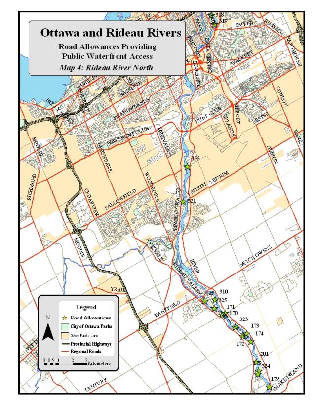
15
|
Rideau
|
Tighe
|
343
|
Open
|
Neighbourhood
|
1
|
Small section of the road allowance included in
the inventory of city parks
|
|
310
|
Rideau
|
Hill
|
1000
|
Open
|
Neighbourhood
|
1
|
Grass bordered by hedges and trees, bench and
stored boats, essentially a neighbourhood park
|
|
325
|
Rideau
|
Van Vliet
|
1060
|
Open
|
Neighbourhood
|
1
|
Grass bordered by trees, forested wetland on one
side, good access to the shoreline
|
|
170
|
Osgoode
|
Rideau Forest
|
2288
|
Closed
|
Neighbourhood
|
3
|
Used as a driveway to an adjacent home, forested
closer to the river, no public use
|
|
171
|
Rideau
|
Kelly-Marie
|
800
|
Open
|
Neighbourhood
|
1
|
Gravel laneway with deep ditches on both sides,
muck/sand shoreline
|
|
172
|
Rideau
|
Southwick
|
350
|
Open
|
Neighbourhood
|
1
|
Asphalt ends 15 metres from the shoreline,
grass, required access to home on the north side of the RA
|
|
173
|
Osgoode
|
River
|
2190
|
Open
|
Neighbourhood
|
3
|
Access to shoreline blocked, no public use
|
|
323
|
Rideau
|
Boucher
|
600
|
Open
|
Neighbourhood
|
1
|
Grass, blocked to vehicles, neighbourhood park
|
|
174
|
Rideau
|
Rideau Narrows
|
1039
|
Closed
|
Neighbourhood
|
1
|
Grass, blocked to vehicles, neighbourhood park,
hedges on both sides, steps down to the shoreline
|
|
201
|
Rideau
|
Phelan
|
4499
|
Closed
|
Conservation
|
1
|
Mixture of grasses, forest and wetlands, no
public activity
|
|
178
|
Osgoode
|
Summerside
|
980
|
Closed
|
Neighbourhood
|
1
|
|
|
324
|
Rideau
|
Clingin
|
841
|
Closed
|
Neighbourhood
|
1
|
Forested, stone dust trail leading to dock,
neighbourhood park
|
|
179
|
Osgoode
|
Doyle
|
2333
|
Open
|
Neighbourhood
|
3
|
Site used and maintained by adjacent landowner,
steep slope down to the shoreline, no public activity
|
|
10
|
Rideau
|
Greenline
|
720
|
Open
|
Community
|
1
|
Road allowance adjacent to Reeve Craig Park,
boat ramp and parking
|
|
281
|
Rideau
|
Malakoff
|
600
|
Open
|
Community
|
1
|
Gravel roadway, direct access to shoreline,
natural ramp
|
|
283
|
Rideau
|
Hebron
|
2000
|
Open
|
Neighbourhood
|
3
|
Gated laneway, pasture with a natural shoreline,
no public activity
|
Table 5: Rideau River Road Allowances: Summary Table and
Location Maps
Appendix 1
Road Allowances
A
road allowance is land that has been set aside either at the time of the
initial land survey or during the land development process for transportation
purposes. All of the road allowances identified in this study are public
property owned by the City of Ottawa. Active road allowances are either “open”
or “unopened”. Road allowances cannot be zoned and, while they are often used
to delimit a zoning designation, unless a zoning designation boundary exists,
zoning flows over an allowance to the adjacent property.
Open Road Allowances
Open
road allowances are roadways that have been deemed to have a transportation
function and have been developed (improved) and are usually maintained for
motor vehicle use by the City. There are however, instances where a portion of
an open road allowance has never been developed as a road (unimproved) or where
a portion of the road is developed but not maintained to the same standard as
the rest of the road. Field investigations have revealed that this is a common
situation for open road allowances providing waterfront access. Frequently, the
portion of the road allowance from the shoreline back to the intersection with
a road paralleling the shoreline has not been improved, or in certain instances
provides vehicular access to a few residential properties. Landowners fronting
on an open road allowance must apply for a permit for vehicular access to the
roadway from their property.
Unopened Road Allowances
Unopened
road allowances are properties that in the future may have a transportation
function but which have not yet been developed. The condition of unopened road
allowances vary, some have a gravel surface while others are completely natural
with no indication that the land is a roadway. Property owners that abut an
unopened road allowances can apply for a private (vehicular) access permit. The
City can open and improve the road allowance or enter into an agreement with
the landowner to permit use of the public road allowance as a private laneway.
In a situation where a property abuts on two roads of which one is an unopened
road allowance, the city can require the owner to access their property by the
open road allowance.
Closed Road Allowances
Closed
road allowances are properties that the City has decided no longer have a
transportation function. Once a road allowance is closed the property assumes
the zoning of the adjacent properties. If the adjacent properties have
different zoning then the zoning of the closed allowance will be split along
the centerline with each side assuming the zoning of the adjacent property.
Alternatively, once a road allowance is closed the City can choose to re-zone
the allowance with different zoning from the adjacent properties. Closing a
road allowance is regulated by the Municipal Act and requires the municipality
to notify any property owners with a direct interest and undertake a broader advertising
of the intent to close.
APPENDIX B AND C
Reference for Appendix B and C - Summary
of Ottawa and Rideau River Road Allowances
|
River
|
Ward
|
Allowances with significant
recreational potential
|
Open
allowances
|
Unopened or Closed allowances
|
Allowances adjacent to, or providing access to
public land
|
Allowances with existing public use
|
Allowances with no existing public use
|
Boat Launch facilities (ramp)
Formal(F)
Informal(I)
|
|
Ottawa
|
West Carleton
|
31
|
12
|
19
|
11
|
22
|
9
|
2F,3I
|
|
Ottawa
|
Kanata
|
2
|
1
|
1
|
1
|
2
|
0
|
|
|
Ottawa
|
Bay
|
4
|
1
|
3
|
4
|
4
|
0
|
2I
|
|
Ottawa
|
Orleans
|
1
|
1
|
0
|
1
|
0
|
1
|
1F
|
|
Ottawa
|
Cumberland
|
2
|
2
|
0
|
2
|
1
|
1
|
1F
|
|
Rideau
|
Capital
|
2
|
2
|
0
|
2
|
2
|
0
|
|
|
Rideau
|
Gloucester/Southgate
|
1
|
1
|
0
|
0
|
0
|
1
|
|
|
Rideau
|
Bell-South Nepean
|
1
|
0
|
1
|
0
|
0
|
1
|
|
|
Rideau
|
Osgoode
|
4
|
2
|
2
|
0
|
0
|
1
|
|
|
Rideau
|
Rideau
|
12
|
9
|
3
|
3
|
9
|
3
|
1F, 1I
|
|
Totals
|
|
60
|
31
|
29
|
24
|
40
|
15
|
5 (F), 6(I)
|
Appendix B: Priority 1 Ottawa and Rideau River Road Allowances
Ottawa River Road Allowances
|
|
Site ID
|
Ward
|
Access Road
|
Area in square
metres
|
Open or
Unopened/Closed Allowance
|
Existing or
Potential Use
|
Priority for Implementation
|
Defining Elements
|
|
122
|
Kanata
|
Riddell
|
5937
|
Unopened
|
Community
|
1
|
Road allowance part of a larger public property, Kanata
Sailing club
|
|
205
|
Bay
|
Grandview
|
1000
|
Open
|
Neighbourhood
|
1
|
Pavement and gravel roadway, laneways on both sides,
shallow gravel beach
|
|
207
|
Bay
|
Grandview
|
1939
|
Unopened
|
Neighbourhood
|
1
|
Partially paved roadway, laneways on both sides, muck
shoreline
|
|
208
|
Bay
|
Grandview
|
1409
|
Unopened
|
Neighbourhood
|
1
|
Gravel roadway, bordered by vegetation on west side,
rocky beach with muck
|
|
209
|
Bay
|
Grandview
|
940
|
Unopened
|
Neighbourhood
|
1
|
Sand/gravel laneway and beach, mature trees on east
side, fairly steep slope
|
|
136
|
Orleans
|
Hiawatha
|
1430
|
Open
|
Neighbourhood
|
1
|
Closed asphalt boat ramp, open grassed areas on both
sides
|
|
148
|
Cumberland
|
Quigley Hill
|
1067
|
Unopened
|
Community
|
1
|
Grass park land, located in a picnic area, road lay-by
site
|
|
150
|
Cumberland
|
RR 174
|
939
|
Unopened
|
Conservation
|
1
|
Mature forest, no roadway, steep rocky shoreline
|
Rideau River Road Allowances
|
|
Site ID
|
Ward
|
Access Road
|
Area in square
metres
|
Open or
Unopened/Closed Allowance
|
Existing or
Potential Use
|
Priority for Implementation
|
Defining Elements
|
|
318
|
Capital
|
Clegg
|
400
|
Open
|
Community
|
1
|
Grass and forest buffer between the end of Clegg and
the Rideau
|
|
319
|
Capital
|
Brantwood
|
6675
|
Open
|
Community
|
1
|
Linear parkland parallels Rideau River, mature trees
with grass
|
|
155
|
Gloucester Southgate
|
Balmoral
|
3457
|
Open
|
Neighbourhood
|
1
|
Grass bordered by trees, no roadway or lanes, natural
shoreline
|
|
15
|
Rideau
|
Tighe
|
343
|
Open
|
Neighbourhood
|
1
|
Small section of the road allowance included in the
inventory of city parks
|
|
310
|
Rideau
|
Hill
|
1000
|
Open
|
Neighbourhood
|
1
|
Grass bordered by hedges and trees, bench and stored
boats, essentially a neighbourhood park
|
|
325
|
Rideau
|
Van Vliet
|
1060
|
Open
|
Neighbourhood
|
1
|
Grass bordered by trees, forested wetland on one side,
good access to the shoreline
|
|
171
|
Rideau
|
Kelly-Marie
|
800
|
Open
|
Neighbourhood
|
1
|
Gravel laneway with deep ditches on both sides,
muck/sand shoreline
|
|
172
|
Rideau
|
Southwick
|
350
|
Open
|
Neighbourhood
|
1
|
Asphalt ends 15 metres from the shoreline, grass,
required access to home on the north side of the RA
|
|
323
|
Rideau
|
Boucher
|
600
|
Open
|
Neighbourhood
|
1
|
Grass, blocked to vehicles, neighbourhood park
|
|
174
|
Rideau
|
Rideau Narrows
|
1039
|
Closed
|
Neighbourhood
|
1
|
Grass, blocked to vehicles, neighbourhood park, hedges
on both sides, steps down to the shoreline
|
|
201
|
Rideau
|
Phelan
|
4499
|
Closed
|
Conservation
|
1
|
Mixture of grasses, forest and wetlands, no public
activity
|
|
178
|
Osgoode
|
Summerside
|
980
|
Closed
|
Neighbourhood
|
1
|
|
|
324
|
Rideau
|
Clingin
|
841
|
Closed
|
Neighbourhood
|
1
|
Forested, stone dust trail leading to dock,
neighbourhood park
|
|
10
|
Rideau
|
Greenline
|
720
|
Open
|
Community
|
1
|
Road allowance adjacent to Reeve Craig Park, boat ramp
and parking
|
|
281
|
Rideau
|
Malakoff
|
600
|
Open
|
Community
|
1
|
Gravel roadway, direct access to shoreline, natural
ramp
|
Appendix C: Priority 2 and 3 Ottawa and
Rideau Rivers Road Allowances
Ottawa River Road Allowances
|
|
Site ID
|
Ward
|
Access Road
|
Area in square
metres
|
Open or
Unopened/Closed Allowance
|
Existing or
Potential Use
|
Priority for Implementation
|
Defining Elements
|
|
219
|
West Carleton
|
MacHardy
|
1200
|
Open
|
Neighbourhood
|
3
|
Forested, no paths or laneways
|
|
317
|
West Carleton
|
Creek
|
1360
|
Unopened
|
Community
|
2
|
Steeply sloped forested property in Fitzroy Harbour, 30
m. wide
|
|
19
|
West Carleton
|
Crossland
|
680
|
Unopened
|
Community
|
2
|
Gravel road way used as public access, boat launch ramp
|
|
20
|
West Carleton
|
Willola
|
1800
|
Open
|
Neighbourhood
|
2
|
Flat, wetland vegetation, mucky shoreline not easily
accessed
|
|
21
|
West Carleton
|
Moorhead
|
870
|
Unopened
|
Neighbourhood
|
2
|
Flat, grass with trees lining the property, maintained
by residents, sand/muck shoreline with grasses
|
|
303
|
West Carleton
|
Moorhead
|
800
|
Open
|
Neighbourhood
|
2
|
Sand beach, partially wooded, local use
|
|
24
|
West Carleton
|
Laurentian
|
1120
|
Unopened
|
Community
|
2
|
Gravel roadway, boat ramp and standpipe for refilling
water trucks
|
|
32
|
West Carleton
|
Dunrobin
|
1200
|
Open
|
Community
|
2
|
Sandy beach with a natural ramp, no facilities, gravel
road
|
|
45
|
West Carleton
|
Opeongo
|
1500
|
Open
|
Neighbourhood
|
2
|
Forested, sloped, private dock
|
|
84
|
West Carleton
|
Bayview
|
923
|
Open
|
Community
|
2
|
Cement and gravel ramp and dock, standpipe for fire
trucks, portable toilet
|
|
81
|
West Carleton
|
Bayview
|
1200
|
Open
|
Neighbourhood
|
2
|
Gravel roadway, very gradual sandy beach, laneways on
both sides
|
|
80
|
West Carleton
|
Bayview
|
920
|
Unopened
|
Neighbourhood
|
2
|
Forested with a sandy track, sand beach
|
|
79
|
West Carleton
|
Bayview
|
920
|
Unopened
|
Neighbourhood
|
2
|
Forested with a gravel laneway used to access house on
the east side, sandy shoreline with grasses
|
|
76
|
West Carleton
|
Bayview
|
920
|
Unopened
|
Neighbourhood
|
2
|
Flat, gravel roadway, sandy beach, a few dispersed
trees
|
|
75
|
West Carleton
|
Bayview
|
2230
|
Unopened
|
Neighbourhood
|
2
|
Flat, sandy track, mostly grass bordered by conifers,
sand beach
|
|
72
|
West Carleton
|
Bayview
|
766
|
Unopened
|
Community
|
2
|
Flat, sandy track providing access to a community
beach, portable toilet
|
|
70
|
West Carleton
|
Bayview
|
1556
|
Unopened
|
Neighbourhood
|
2
|
Flat, sandy/gravel track, access to shoreline, laneways
on both sides
|
|
68
|
West Carleton
|
Bayview
|
1944
|
Unopened
|
Neighbourhood
|
2
|
Flat, forested with a grass understory, sand beach, no
roadway
|
|
67
|
West Carleton
|
Bayview
|
1654
|
Unopened
|
Neighbourhood
|
2
|
Flat, narrow laneway with mature forest, steep slope
down to the shoreline
|
|
66
|
West Carleton
|
Bayview
|
690
|
Open
|
Community
|
2
|
Flat, access to the community beach, portable toilet
and garbage can
|
|
65
|
West Carleton
|
Bayview
|
1530
|
Unopened
|
Neighbourhood
|
2
|
Flat, gravel roadway, access lanes to adjacent homes, a
few mature trees
|
|
61
|
West Carleton
|
Bayview
|
1480
|
Unopened
|
Neighbourhood
|
2
|
Flat, gravel roadway, laneways to houses on both sides,
sandy shoreline
|
|
87
|
West Carleton
|
Bayview
|
1226
|
Unopened
|
Neighbourhood
|
2
|
Flat, forested with a sand/gravel track, laneway on one
side, sand beach
|
|
183
|
West Carleton
|
Armitage
|
1218
|
Unopened
|
Neighbourhood
|
2
|
Forested natural, mature deciduous trees, no road or
pathways, sand beach
|
|
90
|
West Carleton
|
Armitage
|
980
|
Unopened
|
Neighbourhood
|
2
|
Mature wetland forest, no public activities, sandy/muck
shoreline with grasses
|
|
92
|
West Carleton
|
Armitage
|
1000
|
Open
|
Neighbourhood
|
2
|
Forested, mature trees, no roadway, lane to the south,
sand/muck shoreline
|
|
328
|
West Carleton
|
Armitage
|
1655
|
Unopened
|
Neighbourhood
|
|
Laneway providing vehicular access to homes and to the
shoreline
|
|
98
|
West Carleton
|
Rockforest
|
860
|
Open
|
Neighbourhood
|
2
|
Steeply sloping, grass and shrubs, no roadway, no
public use
|
|
110
|
West Carleton
|
Baskins Beach
|
1800
|
Open
|
Neighbourhood
|
2
|
Gravel road, ditches on both sides, rocky shoreline,
diverse scrubby vegetation
|
|
112
|
West Carleton
|
Barlow
|
2278
|
Closed
|
Conservation
|
2
|
Forested wetland with a creek, steep rocky slope
leading down to a shingle beach, no public use
|
|
119
|
West Carleton
|
Thomas A. Dolan
|
960
|
Open
|
Community
|
2
|
Asphalt down to the shore, grass bordered by forest,
memorial garden, sand beach
|
|
121
|
Kanata
|
Berry
|
1600
|
Open
|
Neighbourhood
|
3
|
|
Rideau River Road Allowances
|
|
Site ID
|
Ward
|
Access Road
|
Area in square
metres
|
Open or
Unopened/Closed Allowance
|
Existing or
Potential Use
|
Priority for Implementation
|
Defining Elements
|
|
321
|
Bell-South Nepean
|
Winding Way
|
1363
|
Closed
|
Neighbourhood
|
3
|
Grass with some trees near the shoreline, no public
use, stony shore on crown land
|
|
170
|
Osgoode
|
Rideau Forest
|
2288
|
Closed
|
Neighbourhood
|
3
|
Used as a driveway to an adjacent home, forested closer
to the river, no public use
|
|
173
|
Osgoode
|
River
|
2190
|
Open
|
Neighbourhood
|
3
|
Access to shoreline blocked, no public use
|
|
179
|
Osgoode
|
Doyle
|
2333
|
Open
|
Neighbourhood
|
3
|
Site used and maintained by adjacent landowner, steep
slope down to the shoreline, no public activity
|
A
STRATEGY TO RECOGNIZE AND PROTECT THE PUBLIC WATERFRONT RECREATIONAL ACCESS
FUNCTION OF SELECTED ROAD ALLOWANCES ON THE OTTAWA AND RIDEAU RIVERS
STRATÉGIE VISANT À RECONNAÎTRE ET À PROTÉGER
L’UTILISATION DE CERTAINES EMPRISES ROUTIÈRES EN TANT QUE POINTS D’ACCÈS
RIVERAINS PUBLICS POUR DES ACTIVITÉS RÉCRÉATIVES SUR LES RIVIÈRES RIDEAU ET DES
OUTAOUAIS
Committee members
received correspondence from the following individuals in support of the
report, copies of which are held on file :
a. A.
Bennett, E-mailed comments dated 20 September
b. C.
Fitzpatrick letter dated 20 September
Aaron Burry,
Director of Parks and Recreation provided a PowerPoint presentation of the
item, a copy of which is held on file.
The more salient points noted were as follows:
- this is a policy issue and
outlines a process to examine certain properties the City owns which lead to
the waterfront; the strategy will identify lands that offer existing or
potential public access;
- road allowances do not
provide any particular recognition of these specific areas so it is proposed
that a waterfront access sub-zoning be created; this would allow staff to
proceed with a process that looks at high priority road allowances;
- in 2006-2007 there will be a
conversion of 23 allowances with an established public access function; over
the longer term, there is a potential to convert 31 allowances in West Carleton
ward that offer public access opportunities; however, the latter require
community consensus before moving forward.
With regards to the public consultation, Councillor Feltmate inquired
whether the neighbours of affected shoreline properties were informed. Staff confirmed they had been. The councillor indicated that if we change
the designation of these and there is an expectation or one possible use is
around swimming as a recreational purpose for the area, she inquired whether
the public should expect testing of these sites for ecoli for example. Mr. Burry advised that this particular
report does not speak to changing the function of any of these locations;
therefore, if someone is currently swimming there, they are doing so at their
own risk and without City testing. He
explained that it was not staff’s expectation that the function of these sites
will be changed significantly.
Councillor Cullen noted that this report does not change the function
of these road access to the river, but protects and maintains these accesses as
public property. Mr. Burry confirmed,
but added it is also to recognize an additional function as a river access
point thereby providing a level of review that is higher than would be for a
road allowance. With regards to river
access in West Carleton, the councillor noted that one of the concerns raised by
that community is that rezoning could be a method of developing those sites as
parks. Mr. Burry confirmed that it is
not the intention of the rezoning to spend any money on these lands and that
should the community wish to pursue conversion of use, they would have to apply
to a separate process, which would have to go through Council.
When asked to comment on the recommendations provided in the report by
the Environmental Advisory Committee, Mr. Burry explained that each road
allowance has to be considered individually and these all form the framework
depending on what the community wants to advance with this. If the community is going to adopt this,
then stewardship and some of the other recommendations are going to be included
in that process.
Councillor Doucet referred to the river accesses in his ward and asked
that staff consult with his community to identify more possible access sites
than the two mentioned in the report.
The Director confirmed that staff would work with the councillor with
regards to the possibilities in the downtown area. He agreed that the City should preserve water accesses for the
future so that the City does not end up in the same situation that presently
exists in the downtown area. Councillor
Bédard agreed there should be more accesses provided to residents in the
downtown area, noting the difficulty downtown residents have accessing the
canal and the rivers. Mr. Burry agreed
this is another example of what could be done in the core.
Kathy Black,
resident of Constance Bay objected to the report and requested that the
Committee reject it as written for a variety of reasons, some of which are
noted as follows:
1. The
recommendations are not appropriate for the rural accesses in the former
township of West Carleton.
2. West Carleton residents wish to have status quo with regard to
waterfront road allowances, i.e., “local community” access.
3. On 18 July 2006, the Rural Issues Advisory Committee
refused to endorse the presentation and report as submitted and recommended
that staff be directed to permanently remove from its work plan, any effort
whatsoever to change the status of the waterfront access points abutting the
Ottawa River in West Carleton.
4. The City has
installed illegal outhouses on some accesses in very close proximity to
residents’ private wells; these have been tipped over and have potentially
caused contamination to the water.
5. There is an
incorrect assumption that residents do not want the transportation function to
continue; in fact, the community wants to continue to use the accesses for
transportation, including snowmobiles, ATVs and boat launching; emergency
vehicles and the fire department continue to use these access.
In closing, Ms.
Black recommended:
§
That the report be amended to reflect the RIAC motion
adopted in July
§
Item 2 of Section 9.0 should reflect that West Carleton
residents have loudly and clearly expressed that they support the RIAC motion
and that said wording should be incorporated into the report
§
That the West Carleton accesses remain as they
currently are and not be rezoned; if it is the collective desire of the West
Carleton and Constance Bay residents to do so, they would improve the accesses
to meet the needs of local residents and that the residents will engage the
City if they feel it is appropriate to do so.
A copy of her
written submission which contains additional details is held on file.
Councillor
Cullen questioned what the delegation is opposed to since the lands in question
are already public property. While she
recognized this, Ms. Black explained that most residents do not want any
improvements made to them and recommend that they be kept for local community
use only. When asked what she thought
would happen with the rezoning, Ms. Black was concerned there may be more outhouses
put on those lands, which has already been raised as a health and safety
concern.
In response to
questions posed by the councillor, staff confirmed that what is recommended in
the report does not change the transportation role of the road allowances and
that whatever they are currently being used for, is what they will continue to
be used for. With regards to the
concerns about portable toilets, Mr. Burry stated there are a number of issues
in Constance Bay that are beyond the scope of this report, such as those
related to its beach. He confirmed that
some such amenities have been placed on the road allowance at the request of
residents. He further confirmed that
this report does not include any road allowances in West Carleton and that it
would not create more outhouses on these lands.
In response to a
question posed by Councillor Bédard, Ms. Black acknowledged that the road
allowances were public, but maintained that the beaches are private and
residents want to keep them as such.
The councillor remarked that they are already publicly used and could
not conceive how people could be kept away who were not from the immediate
community. Ms. Black explained that the
community has a different perception of what they want to see done in their
area and are working together collaboratively and cooperatively to develop a
strategy that will work for the residents.
Councillor
Brooks posed a series of questions to the delegation regarding local issues
being governed by the local community and the anticipated increase in traffic
that may result as a result of the rezoning.
Ms. Black believed there was concern on the part of local residents that
if signs are erected it would generate more traffic and she agreed that an
increase in traffic would ultimately result in more by-law related issues.
In response to a
question posed by the Chair, Mr. Burry confirmed this same report would be
considered by the Agriculture and Rural Affairs Committee on 28 September. He added that the report could change or
additional reports could be brought back if additional accesses are brought
forward, but each would be dealt with individually. He commented that what is proposed is a flexible approach to
addressing local needs, i.e., some want signage, some want improvements.
Gerald Jette,
resident of Constance Bay reiterated many of the concerns raised by the
previous delegation and provided the following additional comments:
- believed
that the proposed zoning change removes
the transportation function and creates waterfront parks; access by emergency
vehicles for life-saving operations must take priority over parkland;
- maintained
that reducing the number of accesses will significantly increase the traffic on
the remainder and stress their fragile ecology;
- suggested
that by-law enforcement, not rezoning,
is the answer to protecting these road allowances;
- believed that rezoning would make outhouses
legal and he was particularly concerned about the health risks associated with
tipped outhouses;
- the rezoning contravenes the Village Plan
for Constance Bay; most participants were opposed to waterfront parks and they
envision a residential community – not a tourist destination.
For the reasons
noted, he suggested the Committee
refuse to accept the report as written or not recommend it to Council until the
following are removed:
1. Priority 2
2. Recommendation
2 of Section 9.0
3. Any
other references to West Carleton river accesses in this report except to state
that West Carleton will retain its current access zoning.
A copy of his
submission is held on file.
In response to questions of clarification posed by
Councillor Cullen, the Director confirmed that the proposed rezoning does not
remove the transportation function or create water front parks on these road
allowances. With regards to concerns
that rezoning would make outhouses legal, Mr. Burry indicated that there is
currently nothing in the road allowance zoning that stipulates these cannot be
located on these, but confirmed the report does not legalize their use there
either. He added that West Carleton is
not part of this report, although mention is made of those accesses for
thoroughness, but nothing would be added until there is community
consensus. The Deputy City Manager,
Steve Kanellakos confirmed this fact.
Natasha
Thiessen, President, Crystal Bay Community Association provided the
Committee with a short PowerPoint presentation, a copy of which is held on
file. The more salient comments noted
were as follows:
- there are four road
allowances in Crystal Bay that are reflected in the report: Arden Street, Pitt Street, Jay Street and
Grandview Road; all have served as access to the Ottawa River for over 75 years
and have become an integral part of their community;
- redevelopment of existing
properties has been a source of concern for residents because the abutting
property owners have committed serious encroachments; this has mobilized the
community to ensure these accesses remain protected;
- the CBCA supports adoption
of the recommendations and the preservation of accesses in their current state;
they see it as a means to protect these accesses and are not willing to support
any change to their appearance or use and the Association understands that the
rezoning would provide a greater level of protection for these areas.
In response to a
question posed by the Chair about whether or not tree planting could occur on
these road allowances, Mr. Burry advised that it could if it is the wish of the
community.
Doug Lazier,
resident, Constance Bay spoke as a property owner in Constance Bay for
many years and agreed with the previous suggestion to delete Recommendation 2
of 9.0 from the report. He was
disturbed by the fact that the report contains a summary of the events of the
January 19 meeting, which he attended, at which time there was standing room
only and there was overwhelming support in favour of maintaining status quo.
Councillor Cullen
did not believe that what is proposed will encourage people to use these access
points and should not be seen as promoting their use. He maintained that what the report does is ensure the road
allowance will not be sold off and will be better protected.
That the Health, Recreation and Social
Services Committee recommend Council approve:
1. The strategy (as included in Appendix
A) to recognize and protect the public waterfront recreational access function
of selected road allowances on the Ottawa and Rideau Rivers.
2. The development of a Waterfront Access
Point sub-zoning to recognize the distinct characteristics of municipal
waterfront access points.
3. The implementation of the road
allowance conversion and zoning process for the first priority road allowances
(as identified in Appendix B) where there is significant community support to
proceed.
CARRIED
A
STRATEGY TO RECOGNIZE AND PROTECT THE PUBLIC WATERFRONT RECREATIONAL ACCESS
FUNCTION OF SELECTED ROAD ALLOWANCES ON THE OTTAWA AND RIDEAU RIVERS
STRATÉGIE VISANT À RECONNAÎTRE ET À PROTÉGER
L’UTILISATION DE CERTAINES EMPRISES ROUTIÈRES EN TANT QUE POINTS D’ACCÈS
RIVERAINS PUBLICS POUR DES ACTIVITÉS RÉCRÉATIVES SUR LES RIVIÈRES RIDEAU ET DES
OUTAOUAIS
Mr. A. Burry, Director of
Parks and Recreation, began by explaining that the City owns a significant
number of road allowances. These lands
have been set aside for road purposes and remain in the inventory, but over
time some have assumed other functions.
He explained that the purpose of the report was to set out a strategy
for reviewing the properties and formally recognizing some of the functions
they have assumed over time. Mr. Burry
went on to provide a presentation in which he discussed the overall objectives
of this initiative, provided examples of lands to be reviewed, discussed some
of the issues that have prompted this initiative and he outlined how the
strategy would be implemented. A copy
of his presentation is held on file.
The Committee then heard from the following public delegations.
Ms. A. Thomas, Vice-President of the Crystal Bay Community Association,
began by describing the community of Crystal Bay and its evolution from a group
of seasonal cottages to a vibrant year-round community. She advised that the four Crystal Bay road
allowances, which are part of the initial 23 for conversion, have served as
accesses to the Ottawa River for over 75 years for the purpose of recreation
and have therefore become an integral part of the community. She showed photographs of the four road
allowances in her community, noting that three out of the four had experienced
encroachments due to the redevelopment of existing properties. Ms. Thomas emphasized the importance of
these accesses for the community, submitting that any encroachment would be
devastating. In closing, she urged
Committee to support the report recommendations. She suggested that the report be seen as a means to protect the
accesses, not to change their appearance or their use and she expressed the
Crystal Bay Community Association’s full support of its implementation. Ms. Thomas spoke from a PowerPoint
presentation, which is held on file with the City Clerk.
Ms. M. Hegan, Chair of the Environmental Advisory Committee
(EAC), noted that when the EAC received a presentation from staff about the
strategy in July, it was still being defined, therefore their recommendations
may be little out of date. She advised
that EAC members had attended 2 of the 3 public meetings on this initiative in
order to get a sense of how residents in the affected communities felt about
the access points. She expressed the
EAC’s support for the intent of the strategy; to own, recognize, protect, and
better manage some of the road access, and to keep them in the public
domain. However, she had hoped one of
the objectives of the strategy would have been to balance recreational access
with the protection of shorelines and water quality. She also urged that, when looking at each access road, there be
an understanding of the expectations of the local people. She noted that many residents care for the
properties and she proposed informal stewardship agreements. Because of the nature of the activity, she
felt stewardship agreements would be an excellent collaboration between the
City and those local communities who have taken ownership of the subject
lands. She also recommended that any
signage include stewardship signs, with messages such as “Don’t dump your
garbage”, “This is a species at risk”, etc.
Ms. Hegan felt this would result in a lot more comfort in the community
involved, particularly in West Carleton where residents are unsure about how
the strategy will affect them. In
closing, she urged that any work to be done should reflect the dual intent;
access roads for recreation and better care of the waterways and shorelines.
Mr. G.
Jette, resident of Constance Bay, referenced statements made at the September 21 meeting of the Health,
Recreation and Social Services Committee, and questioned why time and money was
being wasted when nothing would really change from the status quo. He submitted that during a January
19, 2006 meeting at the Kinburn Client Service Centre, West Carleton residents
had overwhelmingly proven their support for the status quo with respect to
accesses from Dunrobin to Fitzroy Harbour.
He added that the Constance Bay Village Plan, adopted by the ARAC and
Council in May, clearly showed consensus on the issue. He wondered why the Ward Councillor was now
prepared to discount the recommendation of the Rural Issues Advisory Committee
and ignore the Constance Bay Village Plan because of a petition from a handful
of people and why he had not informed the residents’ Beach Committee of a
motion he intended to present on this matter.
In closing, Mr. Jette asked Committee to endorse: that West Carleton retain its current public
waterfront access zoning; and that all references to the re-zoning of West
Carleton public waterfront accesses be permanently removed from the
report. A copy of Mr. Jette’s submission is held on file.
Responding to questions from Councillor Cullen, Mr. Burry confirmed that
currently there is no waterfront access zoning on the road allowances and that
staff is proposing a change from road allowance designation to waterfront
access zoning. He agreed that, with
respect to residents’ use of these lands, the status quo will remain. However, he maintained that the proposed
strategy would allow that use to be preserved in the future, even as
communities redeveloped.
In response to questions from Councillor El Chantiry, Mr Burry asserted
that what the report proposes is essentially the same as what the presenters
are asking for, which is to designate the areas as riverfront access points. He
pointed out that they are currently designated as road allowances, which is not
a formal zoning but simply a designation for road purposes.
As requested by Councillor El-Chantiry, Ms. M. L. Filion, Legal Counsel,
explained the distinction between a road allowance and an unopened road
allowance. The distinction is one of
maintenance and expenditure of finances by the City. She explained that with a road allowance, the City must undertake
certain measures on a regular basis to maintain it and keep it clear, whereas
an unopened road allowance is not used for the passage of any vehicles, nor
does the city necessarily expend any money on it at any time. She confirmed that in order to have a
stronger protection for those unprotected road allowances, they need to be
renamed as waterfront access. She submitted it was difficult for the city to
protect them as unopened road allowances because there were no resources to
monitor encroachment onto those properties.
Mr. Burry maintained staff would not move forward on any of the accesses
until there was consensus in the affected communities. He noted that none of the road allowances in
West Carleton had been included in the first part of the strategy. He suggested if residents’ objective was to
have those areas identified as river access points, that was entirely
consistent with the report.
Mr. Jette expressed concerns with respect to residents’ ability to drive
on or park vehicles on the subject lands and with the concept of stewardship of
the subject lands. He worried that the
City would expect residents to maintain the accesses, since it did not have the
resources to do so. He maintained the
subject lands were in fact road accesses because people use them to launch
boats and the Fire Service uses them to access water.
Mr Burry emphasized that the strategy is not a one size fits all
solution. He pointed out that residents
in some areas want everything left exactly as it is, whereas residents in other
areas are asking to do some very basic improvements. He asserted that the strategy would allow both options. He re-iterated that it would not involve
significant change for any of these points, and that anything that is legally
going on there would continue to go on there.
In response to a question from Councillor Thompson, Mr. Burry explained
all the road accesses could not be done at once. He indicated the first 23 would be actioned immediately because
of requests from the public and members of Council. He suggested it would take approximately 2 years to get through
the first group because each one would involve further public consultation and
discussions. He added that, if
stewardship agreements were the desire of the community, staff would work on
them.
Mr. Jette stressed that the Constance Bay Village Plan recommended
maintaining the status quo for access points in that area and that the
community did not want them touched.
Chair Jellett agreed that nobody wanted them touched and he
maintained no one was trying to ban parking or boat launching on those
accesses. He submitted the report was
not changing anything. It was merely
putting a formal name to what was already in place. He also wanted assurances that there would be no hidden or extra
costs to any homeowner adjacent to these properties. Mr. Burry confirmed there was no intention to impose costs on
homeowners. He re-iterated that each
access point would be considered individually and that any recommendations
coming forward would be based on community consensus.
Chair Jellett noted the community’s uncertainty that things
would remain as they are. Mr. Burry
suggested the element of trust would develop over time, as communities saw how
the strategy unfolded in other areas during the first phase and how staff
handled the issues. He recognized the
sensitivity of these issues and assured Committee that staff would involve the
respective communities and Ward Councillors.
In response to a question from Councillor Cullen, Mr Burry indicated
nothing in the report would change the ability of emergency service providers
to use these properties to access the river when they needed to. He clarified that, whereas in Britannia
there is formal access and it is maintained to a high standard, emergency
service providers also use other informal road accesses.
Councillor Brooks questioned whether the City had a responsibility to
maintain those unopened, unmaintained road allowances if they were used by
emergency vehicles. Ms. Filion
explained that under the new Municipal Act, a specific by-law is
required by the City to direct such maintenance. She submitted each road
allowance would have to be reviewed on a one-by-one basis to determine whether
or not there was a maintenance obligation.
She added any by-law would depend on whether the access had been
acknowledged and approved by the City.
In response to questions from Councillor El-Chantiry, Mr.
Burry explained the intent of the sub-zoning category and why the report
proposed to protect 14 of the 39 road allowances in Constance Bay. He indicated the 14 were chosen based on
criteria such as width and relative size.
He re-iterated that of the 23 road allowances being recommended for
immediate action, none were in West Carleton.
Mr. B. McClure, resident of Constance Bay, submitted there was
already a process in place for the sale of road allowances, which included
informing the community. Therefore, he
questioned why this strategy was even being discussed. He expressed concerns with regards to Table
1 of the report, which stated “Criteria used to identify road allowances with
significant existing or potential recreational function.” He feared this potential recreational
function would result in the sites being advertised as parks, leading to an
influx of visitors in an area that could not handle the volume.
Mr. Burry explained that the strategy was undertaken for purposes of
completeness, taking into account the entire City and planning for the future.
He agreed that there were a number of issues in Constance Bay beyond road
allowances, however he submitted this report was not intended to make those
issues go away. He appreciated the concerns of residents, adding that the
strategy provided more tools to deal with encroachment and traffic issues.
In response to a question from Chair Jellett, Mr. Burry assured Committee
that the accesses would not suddenly be advertised or promoted as recreational
areas. He maintained the strategy would merely provide formal recognition and
protection of the informal recreational use that already takes place. He reiterated that staff would be coming
forward with an individual zoning recommendation on each one of the road
allowances and that the intended uses could be clearly stipulated in those
agreements
Mr. D.
Lazier, resident of Constance Bay, began by pointing out that, just as private landowners have remedies if
somebody encroaches on their land, so does the City, even under the current
designation. He suggested the defence against encroachments is not dependant in
any way on this proposed redesignation.
He opposed the approval of the strategy report (appendix A), adding that
should the Committee recommend its approval, he would suggest that the RIAC
motion be passed as an amendment - recommending that City staff be directed to permanently
remove from its work plan any effort whatsoever to change the status of
waterfront access points abutting the Ottawa River in West Carleton Ward. He also requested that recommendation 2 of
the report be deleted. He felt
recommendation 2 was inconsistent because it recommended that nothing be done
until consensus is achieved, implying that City staff would proactively seek
such consensus at some future date.
Councillor Jellett wondered why there was such opposition to a zoning
chance since the access would remain and people would still be able to use the
accesses as they always had. Mr. Lazier
maintained that the status quo worked perfectly, provided the City defended
against encroachments. He echoed the
fears expressed by Mr. McClure, that the proposed designations would result in
proactive measures by the City to bring about recreation functions. He indicated that despite assurances from
Mr. Burry, he would be more comfortable if Committee deleted recommendation
2.
Councillor El Chantiry indicated waterfront accesses had been
an issue in Constance Bay for a very long time. He noted that, both waterfront owners and non-waterfront owners
wanted those accesses maintained in the ownership of the community. He submitted that official designating and
protecting those accesses would eliminate some of the current stress. Although Mr. Lazier agreed with the goal of
protecting the accesses, he felt the status quo was sufficient.
In response to questions from Councillor El-Chantiry, Mr Burry indicated
there had been some difficulty in determining the community’s intentions with
respect to road allowances in West Carleton, he recognized that more time was
needed in that area, and he assured Committee that the next stage would only
move forward when the community was ready to do so.
Ms. J. Nightingale, resident of Constance Bay, simply expressed
concurrence with the comments made by the previous speakers as well as with the
submission to be made by Ms. K. Black.
Ms. J. Currie, resident of Constance Bay, discussed her family’s
history, as long-time residents of Constance Bay. She felt the beaches and waterfront accesses should be available
to all residents. She noted that a
Constance Bay beach protocol committee had been established in order to get
community consensus on the use of the accesses and beaches. She indicated she, and several other
residents, had obtained over 200 signatures on a petition supporting the
suspension of the motion for rezoning road allowances until the Constance Bay
beach protocol committee had completed its work and put forward
recommendations. She submitted that,
although most of the residents wanted to keep the accesses available to all
residents of Constance Bay, they did not want the words “status quo” and “permanently”
to be misinterpreted. She
suggested: they wanted funding from the
City of Ottawa where possible and applicable; they wanted the beaches
maintained; they wanted encroachment on accesses stopped; and they wanted to be
able to use the beaches in total, not just the beaches at the access
points. She added that residents also
wanted: help from the City to make any
changes that may arise from the beach protocol committee’s recommendations;
help with the enforcement of the concerns brought forward by the community; and
to not have accesses sold. She
indicated the residents of Constance Bay were frustrated and wanted these
issues resolved once and for all.
In response to a question form Chair Jellett, Mr Burry confirmed that the
proposed river access zoning would make it more difficult for the property to
be sold, as it would require an additional step.
Ms. K. Black, resident of Constance Bay, requested that West
Carleton retain its current access zoning, that the report be adopted for the
other than West Carleton public waterfront accesses, and that the
recommendations contained in this report for West Carleton not go forward to
Council until the outstanding inconsistencies had been resolved. She also listed several concerns that
remained unaddressed by City staff after her presentation at the HRSS Committee
meeting of September 21. Ms. Black
listed the information she had requested from staff and suggested that, before
the Committee consider making any recommendations on the report, they may wish to
validate some of the details in the report concerning West Carleton. A copy of her submission is held on file.
Responding to questions from Councillor Cullen, Mr. Burry
confirmed that the report did not propose a City work program expenditure on
converting the allowances to parks. He
also confirmed that nothing would change residents’ ability to access the
Ottawa River as a result of this report.
He clarified the transportation function of the road allowances, noting
that tractors, snowmobiles and other recreational vehicles were not considered
transportation functions for the purposes of this report.
Mr Burry also confirmed that this report did not deal with outhouses on
public accesses. However, he clarified that on lands owned by the City, porta-potties
could legally be placed by the City but could not be placed by private
residents or community groups without express permission. He agreed with a comment made by Councillor
Cullen, that the unused sites were vulnerable to being sold and therefore the
new designation would better protect these lands without changing their
function.
Ms. Black read a written submission on behalf of Ms. A.
Auger-Johnstone, resident of Constance Bay, into the record. In her submission, Ms. Auger Johnstone
requested that West Carleton retain its current access zoning and that the
report be adopted for waterfront accesses in areas other than West Carleton,
and that the recommendations in this report pertaining to West Carleton not go
forward to Council until the outstanding inconsistencies had been
resolved. A copy of her submission is
held on file.
Mr. F. Gramann, resident of Constance Bay, indicated he
represented the majority of Constance Bay.
He referenced a petition, signed by 218 Constance Bay residents and submitted
to Councillor El-Chantiry. He noted
that the Constance Bay beach committee, of which he was a member, was formally
formed three months ago. He indicated
this committee would come to the City and present the Constance Bay community’s
wishes wit respect to waterfront accesses.
He believed all residents wanted to protect the waterfront accesses but
that there were differences of opinion with respect to how that should be
done. He expressed a desire to have the
community work together to achieve consensus.
Councillor El Chantiry read the preamble of the aforementioned petition
into the record:
“We the undersigned residents of Constance
Bay are opposed to the wording of the Rural Issues Advisory Committee (RIAC )
motion, “…that the RIAC recommended to the ARAC that City staff be directed
to permanently remove from its work plan any effort whatsoever to change
the status of waterfront access points abutting the Ottawa River in West
Carleton ward.” City staff has
informed residents at a recent meeting that the City has no intention of
pursuing rezoning of the accesses in West Carleton without community consensus,
which has not been determined at this time. The wording of this motion will
remove the opportunity for collective community decisions related to water
access zoning and possible future benefit could be lost. Access issues are currently being addressed
in a 39-member Beach Protocol Committee and future decisions could not be
implemented under the current wording (eg. rezoning, funding etc.). Until the community has a further opportunity
to examine its road access points, re-zoning decisions should not be made. Decisions should be made after public
meetings are held, surveys have been tabulated, and recommendations from the
community have been finalized. We are
expecting that this will be completed by late spring or early summer of 2007.”
Councillor El-Chantiry
submitted the petition for the record (held on file with the City Clerk)
re-iterated that it had been signed by 218 residents. He also referenced a letter he received from the Constance Bay
Community Association with respect to the RIAC recommendation. He noted that the Community Association
wanted the Constance Bay accesses removed until the community had completed its
beach and waterfront activities, as defined in the Village Plan. Based on these submissions, the Councillor
acknowledged that the community was divided on this issue. However, he submitted that the community
association and the residents who had signed the petition simply wanted the
word “permanently” removed until the community could reach a consensus. He discussed the great community efforts
that had gone into the Village Plan and noted the community needed a little
more time to deal with its waterfront issues.
He recognized and respected the efforts of other communities and Ward
Councillors to move forward on this initiative and indicated he did not wish to
hold up the entire report, though he would ask that West Carleton be left out
at this time.
In response to a
question from Councillor Brooks, Mr. Burry clarified that from his perspective,
there were no inconsistencies between the report and the petition. However, he believed Councillor El-Chantiry
would be proposing a motion, which would strengthen the petition’s intent. He noted the report proposes a strategy to
recognize and protect waterfront accesses in general. It then goes on to deal specifically with 23 of those accesses where
there is community consensus to move forward.
He indicated staff would come back to the other, including those in West
Carleton, only when there was community consensus to move forward with
them.
Councillor El Chantiry acknowledged residents’ fears that Constance Bay
would become a public beach area. He
submitted that Constance Bay’s problems went beyond waterfront access; they
include issues such as parking, beach maintenance and porta-potties. He acknowledged that the current report did
not address all the problems. However,
he supported Councillor Cullen’s desire to deal with waterfront access issues
in his Ward. In conclusion, he asked
that his community be given more time to resolve its waterfront access issues
and that the door not be shut by “permanently” removing West Carleton from the
strategy. He introduced a motion to
that effect:
WHEREAS the Rural Issues Advisory Committee
has heard concerns, as part of its consultation with staff around the
development of this report, from residents of West Carleton and formerly
expressed concerns that the City will be proceeding with the rezoning of road
allowances with river access in West Carleton;
AND WHEREAS the implementation of the
Village Plan for Constance Bay is not complete and a significant number of road
allowances with river access in West Carleton are in Constance Bay;
AND WHEREAS residents of Constance Bay, with
the assistance of their Councillor, have formed a Constance Bay Beach Committee
to further examine the issue;
AND WHEREAS the staff report does not
include any proposed conversion in West Carleton and the report clearly
indicates that “no work on the conversion of these properties will be
undertaken until a consensus has been achieved by the residents of the Ward on
how to best recognize and protect these properties”;
AND WHEREAS Committee and Council must
consider each request for rezoning of a road allowance individually in
accordance with the Ontario Planning
Act;
THEREFORE BE IT RESOLVED THAT the
Agriculture and Rural Affairs Committee recommend to Council that the report be
amended to include a fourth recommendation as follows:
That City staff support the work of the
Constance Bay Beach committee and, as staff will be bringing forward reports in
the future related to consideration by Committee and Council of the conversion
of additional road allowances with river access, that no road allowances in
West Carleton be considered for conversion until requested by the Councillor
for that Ward.
Councillor Cullen asserted that, while some presenters felt the status
quo was sufficient to protect the allowances, the status quo was not working in
his Ward. He discussed some of the
issues that could, and do, arise from the fact that these road allowances were
not formally recognized and protected.
He maintained the need for a policy to direct the City, so that when
someone tries to buy a road allowance, they can be told that it is not for sale
because it has a waterfront access designation. He expressed his support for the staff report and stressed the
importance of recommendation 2, the development of a waterfront access point
sub-zoning to recognize the distinct characteristics of municipal waterfront
access points. He also supported recommendation 3 because it would allow some
areas to be addressed immediately at the same time as it would allow for delay
in areas where communities were not ready or willing to move forward.
Councillor Brooks indicated he would support the report and Councillor
El-Chantiry’s motion. He also wished to
ensure that, should the residents in Constance Bay eventually determine that
they wanted West Carleton to be permanently removed from any further action,
the Committee would accept that recommendation as the will of the majority of
residents. Chair Jellett stated that,
while nobody could speak for the future Council, the intent was clear; that the
Committee wanted the people of West Carleton to have the opportunity to decide
for themselves what was best for their community.
Councillor El-Chantiry thanked the Committee for its support and thanked
the residents for their work and for coming forward to express themselves.
In response to a question from Chair Jellett regarding the ownership of a
particular location in Cumberland Ward, Mr. Burry reminded Committee that as
staff went through each of the 23 initial road allowances for zoning, the
details with respect to each one would be reviewed. However, he assured Chair Jellett that the referenced site was
publicly owned, either by the National Capital Commission or by the City.
Councillor Thompson asked for assurance that land owners in
Osgoode Ward had been informed and consulted, pointing out that there is no
community association, just individuals that own property along the river. Mr. Burry indicated all the people living in
that general vicinity had been contacted.
He reminded the Committee that staff would review each road allowance
individually, with more public consultation and more notifications. He stressed
that approval of this report did not constitute approval of any re-zonings. It would merely get the ball rolling in
terms of a process for reviewing the various road allowances.
The following written
submissions were also received by the Committee and are held on file with the
City Clerk:
·
Memo from the Environmental Advisory Committee dated 25
August 2006;
·
Memo from the Rural Issues Advisory Committee dated 22
September 2006; and
·
Memo from the Health, Recreation and Social Services
Committee dated 26 September 2006.
Moved by Councillor E. El-Chantiry
WHEREAS the Rural Issues Advisory Committee
has heard concerns, as part of its consultation with staff around the
development of this report, from residents of West Carleton and formerly
expressed concerns that the City will be proceeding with the rezoning of road
allowances with river access in West Carleton;
AND WHEREAS the implementation of the
Village Plan for Constance Bay is not complete and a significant number of road
allowances with river access in West Carleton are in Constance Bay;
AND WHEREAS residents of Constance Bay, with
the assistance of their Councillor, have formed a Constance Bay Beach Committee
to further examine the issue;
AND WHEREAS the staff report does not
include any proposed conversion in West Carleton and the report clearly
indicates that “no work on the conversion of these properties will be
undertaken until a consensus has been achieved by the residents of the Ward on
how to best recognize and protect these properties”;
AND WHEREAS Committee and Council must
consider each request for rezoning of a road allowance individually in accordance
with the Ontario Planning Act;
THEREFORE BE IT RESOLVED THAT the
Agriculture and Rural Affairs Committee recommend to Council that the report be
amended to include a fourth recommendation as follows:
That City staff support the work of the Constance
Bay Beach committee and, as staff will be bringing forward reports in the
future related to consideration by Committee and Council of the conversion of
additional road allowances with river access, that no road allowances in West
Carleton be considered for conversion until requested by the Councillor for
that Ward.
CARRIED
The committee then voted on the report as
amended.
That the Health, Recreation
and Social Services Committee and the Agriculture and Rural Affairs Committee
recommend Council approve the following, as amended:
1. The strategy (as included in Appendix A)
to recognize and protect the public waterfront recreational access function of
selected road allowances on the Ottawa and Rideau Rivers.
2. The development of a Waterfront Access
Point sub-zoning to recognize the distinct characteristics of municipal
waterfront access points.
3. The implementation of the road allowance
conversion and zoning process for the first priority road allowances (as
identified in Appendix B) where there is significant community support to
proceed.
4. WHEREAS the Rural Issues Advisory Committee
has heard concerns, as part of its consultation with staff around the
development of this report, from residents of West Carleton and formerly
expressed concerns that the City will be proceeding with the rezoning of road
allowances with river access in West Carleton;
AND WHEREAS the implementation of the
Village Plan for Constance Bay is not complete and a significant number of road
allowances with river access in West Carleton are in Constance Bay;
AND WHEREAS residents of Constance Bay, with
the assistance of their Councillor, have formed a Constance Bay Beach Committee
to further examine the issue;
AND WHEREAS the staff report does not
include any proposed conversion in West Carleton and the report clearly
indicates that “no work on the conversion of these properties will be
undertaken until a consensus has been achieved by the residents of the Ward on
how to best recognize and protect these properties”;
AND WHEREAS Committee and Council must
consider each request for rezoning of a road allowance individually in
accordance with the Ontario Planning
Act;
THEREFORE BE IT RESOLVED THAT the
Agriculture and Rural Affairs Committee recommend to Council that the report be
amended to include a fourth recommendation as follows:
That City staff support the
work of the Constance Bay Beach committee and, as staff will be bringing
forward reports in the future related to consideration by Committee and Council
of the conversion of additional road allowances with river access, that no road
allowances in West Carleton be considered for conversion until requested by the
Councillor for that Ward.
CARRIED
as amended
While this strategy focuses on properties with a twenty-metre
width (as this was assumed to be the minimum width to offer significant
recreational potential), there are a limited number of public rights of way
whose widths are less than 20 metres that offer recreational potential for the
immediate neighbourhood where they are situated. While these properties were
not considered in this strategy they could be assessed for re-zoning in the
future
It is proposed that for road allowances with laneways
that provide legal and required access routes to private properties that only
the portion of the road allowance that is not required to access the adjacent
properties be closed and re-zoned.